

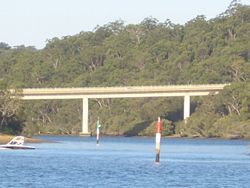
Alfords Point Bridge, New South Wales
Encyclopedia
Georges River
The Georges River is a waterway in the state of New South Wales in Australia. It rises to the south-west of Sydney near the coal mining town of Appin, and then flows north past Campbelltown, roughly parallel to the Main South Railway...
. It was opened on the 7 September 1973. The bridge links Padstow Heights
Padstow Heights, New South Wales
Padstow Heights, a suburb of local government area City of Bankstown, is located 23 kilometres south-west of the Sydney central business district, in the state of New South Wales, Australia, and is a part of the South-western Sydney region...
in the City of Bankstown
City of Bankstown
The City of Bankstown is a city and Local Government Area in the Canterbury-Bankstown region of Sydney, New South Wales, Australia, centred on the suburb of Bankstown....
to Alfords Point
Alfords Point, New South Wales
Alfords Point is a suburb in southern Sydney, in the state of New South Wales, Australia. Alfords Point is located 28 kilometres south of the Sydney central business district, in the local government area of the Sutherland Shire in the area commonly called Menai...
in the Sutherland Shire
Sutherland Shire
The Sutherland Shire is a Local Government Area in the Southern Sydney region of Sydney, Australia. Geographically, it is the area to the south of Botany Bay and the Georges River...
. It is part of Metroad 6
Metroad 6
The Metroad 6 is a Metroad in Sydney, Australia. It travels from the Metroad 1 at Princes Highway, Heathcote to Pennant Hills Road/M2 Motorway, in Carlingford.Metroad 6 replaced State Route 45 in February 1999...
.
The two other road crossings over the Georges River downstream of the Alfords Point Bridge are the Captain Cook Bridge
Captain Cook Bridge, New South Wales
The Captain Cook Bridge is one of three major road crossings of the Georges River in Sydney, Australia. It crosses at the mouth of the river into Botany Bay....
, which opened in 1965 and Tom Uglys Bridge
Tom Uglys Bridge
Tom Uglys Bridge is one of three major road crossings of the Georges River in southern Sydney, New South Wales, Australia. It consists of two separate bridges that carry the Princes Highway, linking the St George area at Blakehurst to the Sutherland Shire at Sylvania.- Origin of the name :Tom Uglys...
, which opened in 1929. Tom Uglys Bridge connects Blakehurst
Blakehurst, New South Wales
Blakehurst is a suburb in southern Sydney, in the state of New South Wales, Australia. Blakehurst is located 18 kilometres south of the Sydney central business district, in the local government area of the Municipality of Kogarah and is part of the St George area.Blakehurst is connected to...
to Sylvania
Sylvania, New South Wales
Sylvania is a suburb, in southern Sydney, in the state of New South Wales, Australia. Sylvania is located 22 kilometres south of the Sydney central business district in the Sutherland Shire....
. Captain Cook Bridge connects Sans Souci
Sans Souci, New South Wales
Sans Souci is a southern Sydney suburb in the state of New South Wales, Australia. Sans Souci is 17 kilometres south of the Sydney central business district and lies across the local government areas of the City of Rockdale and the Municipality of Kogarah. It is part of the St George area.Sans...
to Taren Point
Taren Point, New South Wales
Taren Point is a suburb, in southern Sydney, in the state of New South Wales, Australia. Taren Point is located 20 kilometres south of the Sydney central business district in the local government area of the Sutherland Shire....
.
History
The bridge replaced a vehicular punt that previously operated between LugarnoLugarno, New South Wales
Lugarno is a suburb in southern Sydney, in the state of New South Wales, Australia. Lugarno is located 23 kilometres south of the Sydney central business district in the local government area of the City of Hurstville and is part of the St George area....
and Illawong
Illawong, New South Wales
Illawong is a suburb in southern Sydney, in the state of New South Wales, Australia. Illawong is located 27 kilometres south-west of the Sydney Central Business District, in the local government area of the Sutherland Shire in the area commonly called Menai...
.
When the original bridge was built, piles and abutments were built next to it (downstream) for future duplication. A second bridge was opened for southbound traffic on 22 August 2008 leaving the older bridge is for northbound use only.
The new bridge replaces a tidal flow system that was in operation on the singular crossing, providing for greater traffic capacity in the off-peak direction.