
Padstow, New South Wales
Encyclopedia
Suburb
The word suburb mostly refers to a residential area, either existing as part of a city or as a separate residential community within commuting distance of a city . Some suburbs have a degree of administrative autonomy, and most have lower population density than inner city neighborhoods...
of local government area City of Bankstown
City of Bankstown
The City of Bankstown is a city and Local Government Area in the Canterbury-Bankstown region of Sydney, New South Wales, Australia, centred on the suburb of Bankstown....
, is located 22 kilometres inner south-west of the Sydney central business district
Sydney central business district
The Sydney central business district is the main commercial centre of Sydney, New South Wales, Australia. It extends southwards for about 3 kilometres from Sydney Cove, the point of first European settlement. Its north–south axis runs from Circular Quay in the north to Central railway station in...
, in the state of New South Wales
New South Wales
New South Wales is a state of :Australia, located in the east of the country. It is bordered by Queensland, Victoria and South Australia to the north, south and west respectively. To the east, the state is bordered by the Tasman Sea, which forms part of the Pacific Ocean. New South Wales...
, Australia
Australia
Australia , officially the Commonwealth of Australia, is a country in the Southern Hemisphere comprising the mainland of the Australian continent, the island of Tasmania, and numerous smaller islands in the Indian and Pacific Oceans. It is the world's sixth-largest country by total area...
, and is a part of the South-western Sydney
South-western Sydney
South-western Sydney is a general term which is used to describe the metropolitan area in south-west Sydney, New South Wales, Australia. It is part of the Greater Western Sydney area....
region.
Padstow is a mostly residential suburb bounded on the north by Bankstown
Bankstown, New South Wales
Bankstown is a suburb of south-western Sydney, in the state of New South Wales, Australia. Bankstown is located 20 kilometres south-west of the Sydney central business district and is the administrative centre of the local government area of the City of Bankstown.-History:Prior to European...
and on the east by Salt Pan Creek
Salt Pan Creek
Salt Pan Creek is a small creek located in the Salt Pan Creek catchment area, in south-western Sydney, in the state of New South Wales, Australia. It is located between the suburbs of Padstow and Riverwood and feeds into the Georges River. The catchment area covers about 26km2, with 11.7km2 of this...
, which is a stream feeding into the Georges River
Georges River
The Georges River is a waterway in the state of New South Wales in Australia. It rises to the south-west of Sydney near the coal mining town of Appin, and then flows north past Campbelltown, roughly parallel to the Main South Railway...
. The M5 South Western Motorway
M5 South Western Motorway
The M5 South Western Motorway is a privately operated tolled motorway in south-western Sydney, New South Wales, Australia. It forms part of Sydney Metroad 5 and the Sydney Orbital Network...
traverses the northern end of the suburb, which is also the location of a number of light industrial facilities.
A number of the streets in the vicinity of Padstow railway station have Egyptian themes as names, including Arab Road, Cairo Avenue, Pyramid Avenue and Sphinx Avenue. To the east of Padstow, on the border with Revesby there is also a group of streets with outer space
Outer space
Outer space is the void that exists between celestial bodies, including the Earth. It is not completely empty, but consists of a hard vacuum containing a low density of particles: predominantly a plasma of hydrogen and helium, as well as electromagnetic radiation, magnetic fields, and neutrinos....
related names, such as Uranus Road, Mars Street, Neptune Street, Hydrae Street and Vega Street.
History
Padstow was first named Padstow Park Estate after a town called PadstowPadstow
Padstow is a town, civil parish and fishing port on the north coast of Cornwall, England, United Kingdom. The town is situated on the west bank of the River Camel estuary approximately five miles northwest of Wadebridge, ten miles northwest of Bodmin and ten miles northeast of Newquay...
in Cornwall
Cornwall
Cornwall is a unitary authority and ceremonial county of England, within the United Kingdom. It is bordered to the north and west by the Celtic Sea, to the south by the English Channel, and to the east by the county of Devon, over the River Tamar. Cornwall has a population of , and covers an area of...
, England
England
England is a country that is part of the United Kingdom. It shares land borders with Scotland to the north and Wales to the west; the Irish Sea is to the north west, the Celtic Sea to the south west, with the North Sea to the east and the English Channel to the south separating it from continental...
. It was named for being the "holy place of St Petrock" (not to be confused with St Patrick), an important Cornish saint. The estate included the grants of Simon McGuigan (130 acres), Joseph Cunningham (50 acres) and Michael Conroy (40 acres). Timber-getting and farming were the main activities here.
The Padstow Park post office opened in 1927 and the first school opened in January 1929. The railway station opened on the 21st December 1931, which encouraged development in the area, especially after World War II
World War II
World War II, or the Second World War , was a global conflict lasting from 1939 to 1945, involving most of the world's nations—including all of the great powers—eventually forming two opposing military alliances: the Allies and the Axis...
. The suburb’s name was changed to Padstow in 1939.
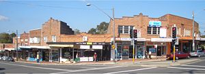
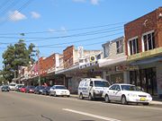
Commercial area
Padstow shopping centre is located around Padstow railway stationPadstow railway station, Sydney
-Transport links:Veolia Transport runs four routes via Padstow railway station:*metrobus M91 - Parramatta and Hurstville*metrobus M92 - Parramatta and Sutherland*Route 927 - between Bankstown and One Tree Point*Route 962 - between Bankstown and Miranda...
. Most of the shops are located on the southern side, around the Howard Road and Padstow Parade intersection, but more shops are located on the northern side past Memorial Drive on Cahors Road.
Transport
Padstow railway stationPadstow railway station, Sydney
-Transport links:Veolia Transport runs four routes via Padstow railway station:*metrobus M91 - Parramatta and Hurstville*metrobus M92 - Parramatta and Sutherland*Route 927 - between Bankstown and One Tree Point*Route 962 - between Bankstown and Miranda...
is on the CityRail
CityRail
CityRail is an operating brand of RailCorp, a corporation owned by the state government of New South Wales, Australia. It is responsible for providing commuter rail services, and some coach services, in and around Sydney, Newcastle and Wollongong, the three largest cities of New South Wales. It is...
East Hills line, west of Riverwood
Riverwood, New South Wales
Riverwood is a suburb in southern Sydney, in the state of New South Wales, Australia. Riverwood is located 18 kilometres south-west of the Sydney central business district and is part of the St George area...
and east of Revesby
Revesby, New South Wales
Revesby, a suburb of local government area City of Bankstown, is located 22 kilometres south-west of the Sydney central business district, in the state of New South Wales, Australia, and is a part of the South-western Sydney region....
.
There are several bus routes that pass through Padstow, all operated by Veolia NSW. The 926 travels from Revesby Heights
Revesby Heights, New South Wales
Revesby Heights, a suburb of local government area City of Bankstown, is located 23 kilometres south-west of the Sydney central business district, in the state of New South Wales, Australia, and is a part of the South-western Sydney region....
to Bankstown
Bankstown, New South Wales
Bankstown is a suburb of south-western Sydney, in the state of New South Wales, Australia. Bankstown is located 20 kilometres south-west of the Sydney central business district and is the administrative centre of the local government area of the City of Bankstown.-History:Prior to European...
, via Padstow and Revesby
Revesby, New South Wales
Revesby, a suburb of local government area City of Bankstown, is located 22 kilometres south-west of the Sydney central business district, in the state of New South Wales, Australia, and is a part of the South-western Sydney region....
. The 927 travels from One Tree Point (the southernmost tip of Padstow Heights
Padstow Heights, New South Wales
Padstow Heights, a suburb of local government area City of Bankstown, is located 23 kilometres south-west of the Sydney central business district, in the state of New South Wales, Australia, and is a part of the South-western Sydney region...
) to Bankstown. (These services developed from routes established by McVicar's Bus Services.) metrobus
Metrobus (Sydney)
Metrobus is a high frequency, high capacity public transportation network in Sydney that links key employment and growth centres. Metrobuses run every 10 minutes during peak periods, 15 minutes during off-peak weekday periods, and 20 minutes on weekends, with the intention of making timetables...
M91 travels from Parramatta
Parramatta, New South Wales
Parramatta is a suburb of Sydney, in the state of New South Wales, Australia. It is located in Greater Western Sydney west of the Sydney central business district on the banks of the Parramatta River. Parramatta is the administrative seat of the Local Government Area of the City of Parramatta...
to Hurstville
Hurstville, New South Wales
Hurstville is a suburb in southern Sydney, in the state of New South Wales, Australia. Hurstville is located 16 kilometres south of the Sydney central business district and is part of the St George area. Hurstville is the administrative centre of the local government area of the City of...
, via Granville, Chester Hill, Bankstown, Padstow and Peakhurst
Peakhurst, New South Wales
Peakhurst is a suburb in southern Sydney, in the state of New South Wales, Australia. Peakhurst is located 21 kilometres south of the Sydney central business district and is part of the St George area. Peakhurst is in the local government area of the City of Hurstville. Peakhurst is colloquially...
. The 962/963 travels from Padstow to Miranda
Miranda, New South Wales
Miranda is a suburb in southern Sydney, in the state of New South Wales, Australia. Miranda is located 24 kilometres south of the Sydney central business district, in the Sutherland Shire....
via Menai
Menai, New South Wales
Menai is a suburb in southern Sydney, in the state of New South Wales, Australia. Menai is located 29 kilometres south of the Sydney central business district in the local government area of the Sutherland Shire.-History:...
. These routes are subject to change mid-2006 with the introduction of new routes in an attempt to increase efficiency by Veolia NSW and the State Government.
Churches
- St Therese Catholic Church.
- Padstow Baptist Community Church
- Padstow Congregational Church
- Padstow Chinese Congregational Church
- Lifegate Community Church Padstow
- Padstow Anglican Church
- Padstow Uniting Church
Schools
Padstow has four schools - three public schools and one Catholic school. All are K-6, with students then moving to schools in the nearby suburbs of RevesbyRevesby, New South Wales
Revesby, a suburb of local government area City of Bankstown, is located 22 kilometres south-west of the Sydney central business district, in the state of New South Wales, Australia, and is a part of the South-western Sydney region....
, Picnic Point
Picnic Point, New South Wales
Picnic Point, a suburb of local government area City of Bankstown, is located 23 kilometres south-west of the Sydney central business district, in the state of New South Wales, Australia, and is a part of South-western Sydney region...
, East Hills
East Hills, New South Wales
East Hills, a suburb of local government area City of Bankstown, is located 26 kilometres south-west of the Sydney central business district, in the state of New South Wales, Australia, and is a part of the South-western Sydney region....
or Milperra
Milperra, New South Wales
Milperra, a suburb of local government area City of Bankstown, is located 24 kilometres south-west of the Sydney central business district in the state of New South Wales, Australia, and is a part of the South-western Sydney region.-History:...
. Padstow North Public School is located on Watson Road, with an access from Halcyon Avenue. Padstow Park Public School is located on Faraday Road but is bounded by Doyle Road and Segers Avenue. Padstow Park Public School gains its title from the original name of the suburb. It is the oldest school in the suburb. The other State owned school is on Chamberlain Road at Padstow Heights
Padstow Heights, New South Wales
Padstow Heights, a suburb of local government area City of Bankstown, is located 23 kilometres south-west of the Sydney central business district, in the state of New South Wales, Australia, and is a part of the South-western Sydney region...
. Padstow Heights Public school down the road from St Therese Primary School. Is large but lacks facilities.
St Therese Primary School is on Chamberlain Road but also has an entrance from Harvey Avenue. St Therese Primary School is a single stream school which was opened in 1963. The presbytry for the church is also on Harvey Road.
Caroline Chisholm is a special needs school for students aged 4-18 years.
Sport
The suburb is home to two Junior Soccer Clubs: Padstow United whose home ground is Playford Park at the intersection of Gibson, Cahors, Watson and Sphinx Roads and the Padstow Hornets which play at Stuart Street Reserve on Stuart Street. In the 1960s the suburb also supported additional soccer clubs including the now defunct clubs of Padstow Pirates Soccer Club (later renamed South Bankstown Soccer Club) and the Padstow Hotspurs Soccer Club. The Padstow Pirates and South Bankstown Soccer clubs also used Playford Park as their home ground.Padstow Park, which is on the corner of Davies Road and Banks Road, is the home ground of the Padstow Panthers Junior Rugby League Club. It was also the home ground of the now defunct St Lukes Junior Rugby League Club. Padstow is also home to Doug Frost Swim School, where Ian Thorpe
Ian Thorpe
Ian James Thorpe OAM , nicknamed the Thorpedo and Thorpey, is an Australian swimmer who specialises in freestyle, but also competes in backstroke and the individual medley. He has won five Olympic gold medals, the most won by any Australian, and with three gold and two silver medals, was the most...
first began swimming.
Notable residents
Australian Rugby League player Brad Woolford is a well known Padstow local. He was a member of the Illawarra SteelersIllawarra Steelers
The Illawarra Steelers are an Australian rugby league football club based in the city of Wollongong, New South Wales. The club competed in Australia's top-level Rugby League competition from 1982, when they, along with the Canberra Raiders, were admitted into the then New South Wales Rugby Football...
from 1982-1987, and played for Australia in the English test of 1984 as a winger.
Politics
For federal elections, Padstow is located in both the marginal Labor federal electoral division of BanksDivision of Banks
The Division of Banks is an Australian Electoral Division in New South Wales. The division was created in 1949 and is named for Sir Joseph Banks, the British scientist who accompanied James Cook on his voyage to Australia in 1770. It has always been based in the south-western suburbs of Sydney,...
which seat is currently held by Daryl Melham
Daryl Melham
Daryl Melham , Australian politician, has been an Australian Labor Party member of the Australian House of Representatives since March 1990, representing the Division of Banks, New South Wales. He was born in Sydney, New South Wales, to a family of Lebanese descent and studied Law and Economics at...
, of the Australian Labor Party
Australian Labor Party
The Australian Labor Party is an Australian political party. It has been the governing party of the Commonwealth of Australia since the 2007 federal election. Julia Gillard is the party's federal parliamentary leader and Prime Minister of Australia...
, and the safe Liberal seat of Division of Hughes
Division of Hughes
The Division of Hughes is an Australian Electoral Division in New South Wales. The division was created in 1955 and is named for Billy Hughes, who was Prime Minister of Australia 1915-23...
held by Craig Kelly.
For NSW state elections, Padstow is located in the marginal Liberal held state electoral district of East Hills
Electoral district of East Hills
East Hills is a state electoral district of the Legislative Assembly in the state of New South Wales, Australia. It is represented by Glenn Brookes of the Liberal Party of Australia.-Members for East Hills:-Election results:...
. This seat is currently held by Glenn Brookes.
External links
- Padstow, Cornwall, UK - Most recent functioning edition from the Internet ArchiveInternet ArchiveThe Internet Archive is a non-profit digital library with the stated mission of "universal access to all knowledge". It offers permanent storage and access to collections of digitized materials, including websites, music, moving images, and nearly 3 million public domain books. The Internet Archive...
.