

Otterham
Encyclopedia
Otterham is a village and a civil parish in north Cornwall
, United Kingdom
. The village is situated approximately ten miles (16 km) south of Bude
and six miles (10 km) north of Camelford
.
Otterham Mill, Otterham Down and Otterham Station (see below) are neighbouring settlements to Otterham village; all take the name from the River Ottery
which rises in the parish.
The parish is in the Hundred of Lesnewth
and Deanery of Trigg Major. It is in the Registration District of Camelford
and belongs to the Boscastle
group of Anglican parishes. Otterham parish is bounded to the north by St Gennys
, to the east by Warbstow
, to the south by Davidstow
and to the west by St Juliot
. The parish is rural with small hamlets and farmsteads spread fairly evenly across it: the population of the parish in the 2001 census was 228.
The parish church of St Denis at is in Otterham village and has a 40 ft tower housing three bells. The church was built in the Norman period but was altered in 1889 when the north transept was demolished.
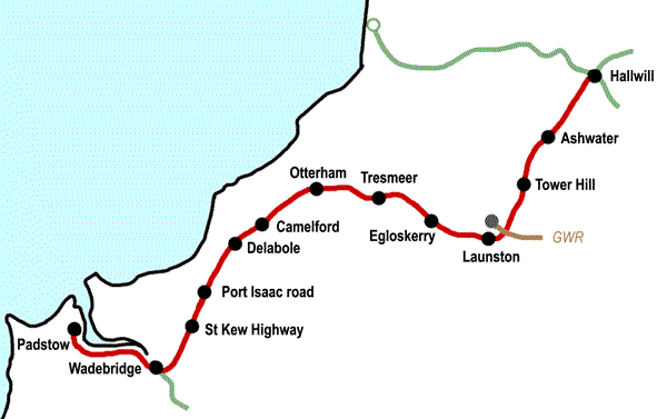 Otterham Station ( 50.675°N 4.613°W ) is a settlement one mile south-west of Otterham village at .
Otterham Station is located at the junction of the A39 trunk road and the B3262 minor road. The settlement grew round the site of the former station on the North Cornwall Railway
which closed in October 1966.
Hendraburnick Down (1009 ft) is south of Otterham Station and there are a number of Bronze Age
barrows
(including Tich Barrow) on the Down. The source of the River Camel
is also on Hendraburnick Down.
For more details about the railway station, see the North Cornwall Railway article.
Cornwall
Cornwall is a unitary authority and ceremonial county of England, within the United Kingdom. It is bordered to the north and west by the Celtic Sea, to the south by the English Channel, and to the east by the county of Devon, over the River Tamar. Cornwall has a population of , and covers an area of...
, United Kingdom
United Kingdom
The United Kingdom of Great Britain and Northern IrelandIn the United Kingdom and Dependencies, other languages have been officially recognised as legitimate autochthonous languages under the European Charter for Regional or Minority Languages...
. The village is situated approximately ten miles (16 km) south of Bude
Bude
Bude is a small seaside resort town in North Cornwall, England, at the mouth of the River Neet . It lies just south of Flexbury, north of Widemouth Bay and west of Stratton and is located along the A3073 road off the A39. Bude is twinned with Ergué-Gabéric in Brittany, France...
and six miles (10 km) north of Camelford
Camelford
Camelford is a town and civil parish in north Cornwall, United Kingdom, situated in the River Camel valley northwest of Bodmin Moor. The town is approximately ten miles north of Bodmin and is governed by Camelford Town Council....
.
Otterham Mill, Otterham Down and Otterham Station (see below) are neighbouring settlements to Otterham village; all take the name from the River Ottery
River Ottery
The River Ottery is a small river in northeast Cornwall, United Kingdom. The river is approximately twenty miles long from its source southeast of Otterham to its confluence with the River Tamar at Nether Bridge, two miles northeast of Launceston.The headwaters of the River Ottery are within the...
which rises in the parish.
The parish is in the Hundred of Lesnewth
Lesnewth (hundred)
Lesnewth Hundred is one of the former hundreds of Cornwall, Trigg was to the south-west and Stratton Hundred to the north-east. Tintagel, Camelford, Boscastle, and Altarnun were in the Hundred of Lesnewth as well as Lesnewth which is now only a small village but in Celtic times was the seat of a...
and Deanery of Trigg Major. It is in the Registration District of Camelford
Camelford
Camelford is a town and civil parish in north Cornwall, United Kingdom, situated in the River Camel valley northwest of Bodmin Moor. The town is approximately ten miles north of Bodmin and is governed by Camelford Town Council....
and belongs to the Boscastle
Boscastle
Boscastle is a village and fishing port on the north coast of Cornwall, England, in the civil parish of Forrabury and Minster. It is situated 14 miles south of Bude and 5 miles north-east of Tintagel....
group of Anglican parishes. Otterham parish is bounded to the north by St Gennys
St Gennys
St Gennys is a coastal civil parish and small settlement in north Cornwall, United Kingdom.The hamlet of St Gennys is situated approximately seven miles southwest of Bude. It is on high ground half-a-mile north of the coastal village of Crackington Haven, the major settlement in the parish...
, to the east by Warbstow
Warbstow
Warbstow is a village and civil parish in Cornwall, England, United Kingdom. The parish has a population of 439 according to the 2001 census.The parish is one of the few left in England to still have an exclave...
, to the south by Davidstow
Davidstow
Davidstow is a civil parish and village in north Cornwall, United Kingdom. The village is north of Bodmin Moor straddling the A395 road about 3 miles north of Camelford....
and to the west by St Juliot
St Juliot
St Juliot is a civil parish in north-east Cornwall, United Kingdom. The parish is entirely rural and the only settlements are the hamlets of Beeny and Tresparrett.-Parish Church:...
. The parish is rural with small hamlets and farmsteads spread fairly evenly across it: the population of the parish in the 2001 census was 228.
The parish church of St Denis at is in Otterham village and has a 40 ft tower housing three bells. The church was built in the Norman period but was altered in 1889 when the north transept was demolished.
Otterham Station
Otterham Station is located at the junction of the A39 trunk road and the B3262 minor road. The settlement grew round the site of the former station on the North Cornwall Railway
North Cornwall Railway
The North Cornwall Railway was a railway line running from Halwill in Devon to Padstow in Cornwall via Launceston, Camelford and Wadebridge, a distance of 49 miles 67 chains. Opened in the last decade of the nineteenth century, it was part of a drive by the London and South Western Railway to...
which closed in October 1966.
Hendraburnick Down (1009 ft) is south of Otterham Station and there are a number of Bronze Age
Bronze Age
The Bronze Age is a period characterized by the use of copper and its alloy bronze as the chief hard materials in the manufacture of some implements and weapons. Chronologically, it stands between the Stone Age and Iron Age...
barrows
Tumulus
A tumulus is a mound of earth and stones raised over a grave or graves. Tumuli are also known as barrows, burial mounds, Hügelgrab or kurgans, and can be found throughout much of the world. A tumulus composed largely or entirely of stones is usually referred to as a cairn...
(including Tich Barrow) on the Down. The source of the River Camel
River Camel
The River Camel is a river in Cornwall, UK. It rises on the edge of Bodmin Moor and together with its tributaries drains a considerable part of North Cornwall. The river issues into the Celtic Sea area of the Atlantic Ocean between Stepper Point and Pentire Point having covered a distance of...
is also on Hendraburnick Down.
For more details about the railway station, see the North Cornwall Railway article.