

T and O map
Encyclopedia

World map
A world map is a map of the surface of the Earth, which may be made using any of a number of different map projections. A map projection is any method of representing the surface of a sphere or other three-dimensional body on a plane....
, sometimes also called a Beatine map or a Beatus map
Beatus map
The Beatus Map or Beatine Map is one of the most relevant cartographic works of the European High Middle Ages: It was originally drawn by the Spanish monk Beatus of Liébana, based on the accounts given by Saint Isidore of Seville, Ptolemy and the Holy Bible...
because one of the earliest known representations of this sort is attributed to Beatus of Liébana
Beatus of Liébana
Saint Beatus of Liébana was a monk, theologian and geographer from the Kingdom of Asturias, in modern northern Spain, who worked and lived in the Picos de Europa mountains of the region of Liébana, in what is now Cantabria and his feast day is February 19.-Biography:He created an important...
, an 8th-century Spanish monk
Monk
A monk is a person who practices religious asceticism, living either alone or with any number of monks, while always maintaining some degree of physical separation from those not sharing the same purpose...
. The map appeared in the prologue to his twelve books of commentaries on the Apocalypse
Apocalypse
An Apocalypse is a disclosure of something hidden from the majority of mankind in an era dominated by falsehood and misconception, i.e. the veil to be lifted. The Apocalypse of John is the Book of Revelation, the last book of the New Testament...
.
History and description
The T-O map represents the physical world as first described by the 7th-century scholar Isidore of SevilleIsidore of Seville
Saint Isidore of Seville served as Archbishop of Seville for more than three decades and is considered, as the historian Montalembert put it in an oft-quoted phrase, "le dernier savant du monde ancien"...
in his Etymologiae
Etymologiae
Etymologiae is an encyclopedia compiled by Isidore of Seville towards the end of his life. It forms a bridge between a condensed epitome of classical learning at the close of Late Antiquity and the inheritance received, in large part through Isidore's work, by the early Middle Ages...
(chapter 14, de terra et partibus):
Although Isidore taught in the Etymologiae that the Earth was "round", his meaning was ambiguous and some writers think he referred to a disc-shaped Earth. However, other writings by Isidore make it clear that he considered the Earth to be globular. Indeed, the theory of a spherical earth
Spherical Earth
The concept of a spherical Earth dates back to ancient Greek philosophy from around the 6th century BC, but remained a matter of philosophical speculation until the 3rd century BC when Hellenistic astronomy established the spherical shape of the earth as a physical given...
had always been the prevailing assumption among the learned since at least Aristotle
Aristotle
Aristotle was a Greek philosopher and polymath, a student of Plato and teacher of Alexander the Great. His writings cover many subjects, including physics, metaphysics, poetry, theater, music, logic, rhetoric, linguistics, politics, government, ethics, biology, and zoology...
, who had divided the spherical earth into zones of climate
Clime
The seven climes was a notion of dividing the Earth into zones in Classical Antiquity....
, with a frigid clime at the poles
Geographical pole
A geographical pole is either of the two points—the north pole and the south pole—on the surface of a rotating planet where the axis of rotation meets the surface of the body...
, a deadly torrid clime near the equator
Equator
An equator is the intersection of a sphere's surface with the plane perpendicular to the sphere's axis of rotation and containing the sphere's center of mass....
, and a mild and habitable temperate clime between the two.
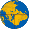
The T and O map is representing only the top-half of the spherical Earth. It was presumably tacitly considered a convenient projection
Map projection
A map projection is any method of representing the surface of a sphere or other three-dimensional body on a plane. Map projections are necessary for creating maps. All map projections distort the surface in some fashion...
of the inhabited parts, the northern temperate half of the globe. Since the southern temperate clime was considered uninhabited, or unattainable, there was no need to depict them on a world map. It was then believed that no one could cross the torrid equatorial clime and reach the unknown lands on the other half of the globe. These imagined lands were called antipodes
Antipodes
In geography, the antipodes of any place on Earth is the point on the Earth's surface which is diametrically opposite to it. Two points that are antipodal to one another are connected by a straight line running through the centre of the Earth....
.
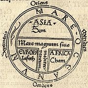
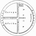
The T is the Mediterranean, the Nile
Nile
The Nile is a major north-flowing river in North Africa, generally regarded as the longest river in the world. It is long. It runs through the ten countries of Sudan, South Sudan, Burundi, Rwanda, Democratic Republic of the Congo, Tanzania, Kenya, Ethiopia, Uganda and Egypt.The Nile has two major...
, and the Don
Don River (Russia)
The Don River is one of the major rivers of Russia. It rises in the town of Novomoskovsk 60 kilometres southeast from Tula, southeast of Moscow, and flows for a distance of about 1,950 kilometres to the Sea of Azov....
(formerly called the Tanais
Tanais
Tanais is the ancient name for the River Don in Russia. Strabo regarded it as the boundary between Europe and Asia.In antiquity, Tanais was also the name of a city in the Don river delta that reaches into the northeasternmost part of the Sea of Azov, which the Greeks called Lake Maeotis...
) dividing the three continent
Continent
A continent is one of several very large landmasses on Earth. They are generally identified by convention rather than any strict criteria, with seven regions commonly regarded as continents—they are : Asia, Africa, North America, South America, Antarctica, Europe, and Australia.Plate tectonics is...
s, Asia
Asia
Asia is the world's largest and most populous continent, located primarily in the eastern and northern hemispheres. It covers 8.7% of the Earth's total surface area and with approximately 3.879 billion people, it hosts 60% of the world's current human population...
, Europe
Europe
Europe is, by convention, one of the world's seven continents. Comprising the westernmost peninsula of Eurasia, Europe is generally 'divided' from Asia to its east by the watershed divides of the Ural and Caucasus Mountains, the Ural River, the Caspian and Black Seas, and the waterways connecting...
and Africa
Africa
Africa is the world's second largest and second most populous continent, after Asia. At about 30.2 million km² including adjacent islands, it covers 6% of the Earth's total surface area and 20.4% of the total land area...
, and the O is the encircling ocean
Ocean
An ocean is a major body of saline water, and a principal component of the hydrosphere. Approximately 71% of the Earth's surface is covered by ocean, a continuous body of water that is customarily divided into several principal oceans and smaller seas.More than half of this area is over 3,000...
. Jerusalem was generally represented in the center of the map. Asia was typically the size of the other two continents combined. Because the sun rose in the east, Paradise (the Garden of Eden) was generally depicted as being in Asia, and Asia was situated at the top portion of the map.
Cartography
Cartography is the study and practice of making maps. Combining science, aesthetics, and technique, cartography builds on the premise that reality can be modeled in ways that communicate spatial information effectively.The fundamental problems of traditional cartography are to:*Set the map's...
could yield extremely detailed maps in addition to simple representations. The earliest maps had only a few cities and the most important bodies of water noted. The four sacred rivers of the Holy Land
Holy Land
The Holy Land is a term which in Judaism refers to the Kingdom of Israel as defined in the Tanakh. For Jews, the Land's identifiction of being Holy is defined in Judaism by its differentiation from other lands by virtue of the practice of Judaism often possible only in the Land of Israel...
were always present. More useful tools for the traveler were the itinerary, which listed in order the names of towns between two points, and the periplus
Periplus
Periplus is the Latinization of an ancient Greek word, περίπλους , literally "a sailing-around." Both segments, peri- and -plous, were independently productive: the ancient Greek speaker understood the word in its literal sense; however, it developed a few specialized meanings, one of which became...
that did the same for harbors and landmarks along a seacoast. Later maps of this same conceptual format featured many rivers and cities of Eastern as well as Western Europe, and other features encountered during the Crusades
Crusades
The Crusades were a series of religious wars, blessed by the Pope and the Catholic Church with the main goal of restoring Christian access to the holy places in and near Jerusalem...
. Decorative illustrations were also added in addition to the new geographic features. The most important cities would be represented by distinct fortifications and towers in addition to their names, and the empty spaces would be filled with mythical creatures.