

Oahe Dam
Encyclopedia
The Oahe Dam is a large dam
along the Missouri River
, just north of Pierre, South Dakota
in the United States
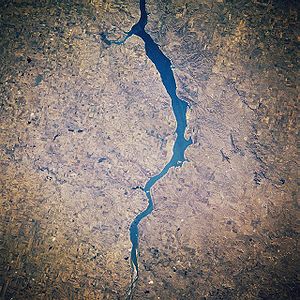
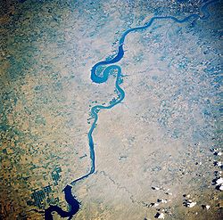
. It creates Lake Oahe
, the fourth largest artificial reservoir
in the United States, which stretches 231 miles (371.8 km) up the course of the Missouri to Bismarck, North Dakota
. The dam's powerplant provides electricity for much of the north-central United States. It is named for the Oahe Indian Mission established among the Lakota Sioux in 1874.
The project provides flood control, electric power, irrigation, and navigation benefits, estimated by the Corps of Engineers at $150,000,000 per year.
passed through what is now Lake Oahe while exploring the Missouri River.
Oahe Dam was authorized by the Flood Control Act of 1944
, and construction by the United States Army Corps of Engineers
began in 1948. The earth main dam reached its full height in October, 1959. It was officially dedicated by President John F. Kennedy
on August 17, 1962, the year in which it began generating power
. The original project cost was $340,000,000.
lost 150000 acres (607 km²) bringing it down to 2850000 acres (11,534 km²) today. Standing Rock Reservation lost 55993 acres (227 km²) leaving it with 2300000 acres (9,308 km²). Much of the land was taken by eminent domain claims made by the Bureau of Reclamation. Over and above the land loss, most of the reservations' prime agricultural land was included in the loss. The loss of this land had a dramatic effect on the Indians who lived on the reservations. Most of the land was unable to be harvested (to allow the trees to be cut down for wood, etc.) before the land was flooded over with water. One visitor to the reservations later asked why there were so few older Indians on the reservations, and was told that "the old people had died of heartache" after the construction of the dam and the loss of the reservations' land.
Huff Archeological Site
is a fortified Mandan village site on what is now the bank of Lake Oahe. It is designated a National Historic Landmark
, but is endangered by erosion pressure from the lake.
Dam
A dam is a barrier that impounds water or underground streams. Dams generally serve the primary purpose of retaining water, while other structures such as floodgates or levees are used to manage or prevent water flow into specific land regions. Hydropower and pumped-storage hydroelectricity are...
along the Missouri River
Missouri River
The Missouri River flows through the central United States, and is a tributary of the Mississippi River. It is the longest river in North America and drains the third largest area, though only the thirteenth largest by discharge. The Missouri's watershed encompasses most of the American Great...
, just north of Pierre, South Dakota
Pierre, South Dakota
Pierre is the capital of the U.S. state of South Dakota and the county seat of Hughes County. The population was 13,646 at the 2010 census, making it the second least populous state capital after Montpelier, Vermont...
in the United States
United States
The United States of America is a federal constitutional republic comprising fifty states and a federal district...
. It creates Lake Oahe
Lake Oahe
Lake Oahe is a large reservoir behind Oahe Dam on the Missouri River beginning in central South Dakota and continuing north into North Dakota in the United States. The lake has an area of and a maximum depth of . By volume, it is the fourth-largest reservoir in the US. Lake Oahe has a length of...
, the fourth largest artificial reservoir
Reservoir
A reservoir , artificial lake or dam is used to store water.Reservoirs may be created in river valleys by the construction of a dam or may be built by excavation in the ground or by conventional construction techniques such as brickwork or cast concrete.The term reservoir may also be used to...
in the United States, which stretches 231 miles (371.8 km) up the course of the Missouri to Bismarck, North Dakota
Bismarck, North Dakota
Bismarck is the capital of the U.S. state of North Dakota and the county seat of Burleigh County. It is the second most populous city in North Dakota after Fargo. The city's population was 61,272 at the 2010 census, while its metropolitan population was 108,779...
. The dam's powerplant provides electricity for much of the north-central United States. It is named for the Oahe Indian Mission established among the Lakota Sioux in 1874.
The project provides flood control, electric power, irrigation, and navigation benefits, estimated by the Corps of Engineers at $150,000,000 per year.
History
In September and October 1804, the Lewis and Clark ExpeditionLewis and Clark Expedition
The Lewis and Clark Expedition, or ″Corps of Discovery Expedition" was the first transcontinental expedition to the Pacific Coast by the United States. Commissioned by President Thomas Jefferson and led by two Virginia-born veterans of Indian wars in the Ohio Valley, Meriwether Lewis and William...
passed through what is now Lake Oahe while exploring the Missouri River.
Oahe Dam was authorized by the Flood Control Act of 1944
Flood Control Act of 1944
The Pick-Sloan Flood Control Act of 1944 , enacted in the 2nd session of the 78th Congress, is U.S. legislation that authorized the construction of numerous dams and modifications to previously existing dams, as well as levees across the United States...
, and construction by the United States Army Corps of Engineers
United States Army Corps of Engineers
The United States Army Corps of Engineers is a federal agency and a major Army command made up of some 38,000 civilian and military personnel, making it the world's largest public engineering, design and construction management agency...
began in 1948. The earth main dam reached its full height in October, 1959. It was officially dedicated by President John F. Kennedy
John F. Kennedy
John Fitzgerald "Jack" Kennedy , often referred to by his initials JFK, was the 35th President of the United States, serving from 1961 until his assassination in 1963....
on August 17, 1962, the year in which it began generating power
Electricity generation
Electricity generation is the process of generating electric energy from other forms of energy.The fundamental principles of electricity generation were discovered during the 1820s and early 1830s by the British scientist Michael Faraday...
. The original project cost was $340,000,000.
Statistics
- Dam height: 245 feet (74.7 m)
- Dam volume of earth fill: 92,000,000 cubic yards (70,000,000 m³)
- Dam volume of concrete: 1,122,000 cubic yards (858,000 m³)
- Spillway width: 456 feet (139 m)
- Spillway crest elevation: 1596.5 feet (486.6 m)
- Lake maximum depth: 205 feet (62.5 m)
- Plant discharge 56000 cuft/s
- Water speed through intake tunnels: 11 mph (5 m/s)
- Intake tunnel length: 3,650 feet (average) (1110 m)
- Number of turbinesWater turbineA water turbine is a rotary engine that takes energy from moving water.Water turbines were developed in the 19th century and were widely used for industrial power prior to electrical grids. Now they are mostly used for electric power generation. They harness a clean and renewable energy...
: 7, Francis type, 100 RPM - Power generated per turbine: 112.29 MWMW-Transportation:* Maintenance of way, railroad upkeep* Maya Island Air IATA airline designator-Games:* Mafia Wars, a game on Facebook* MechWarrior, a profession in the fictional universe of BattleTech...
- reservoir storage capacity: 23500000 acre.ft.
- States served with electricity: North DakotaNorth DakotaNorth Dakota is a state located in the Midwestern region of the United States of America, along the Canadian border. The state is bordered by Canada to the north, Minnesota to the east, South Dakota to the south and Montana to the west. North Dakota is the 19th-largest state by area in the U.S....
, South DakotaSouth DakotaSouth Dakota is a state located in the Midwestern region of the United States. It is named after the Lakota and Dakota Sioux American Indian tribes. Once a part of Dakota Territory, South Dakota became a state on November 2, 1889. The state has an area of and an estimated population of just over...
, NebraskaNebraskaNebraska is a state on the Great Plains of the Midwestern United States. The state's capital is Lincoln and its largest city is Omaha, on the Missouri River....
, MinnesotaMinnesotaMinnesota is a U.S. state located in the Midwestern United States. The twelfth largest state of the U.S., it is the twenty-first most populous, with 5.3 million residents. Minnesota was carved out of the eastern half of the Minnesota Territory and admitted to the Union as the thirty-second state...
and MontanaMontanaMontana is a state in the Western United States. The western third of Montana contains numerous mountain ranges. Smaller, "island ranges" are found in the central third of the state, for a total of 77 named ranges of the Rocky Mountains. This geographical fact is reflected in the state's name,... - Number of recreation areas around lake: 51
- Shore length: 2250 miles (3,621 km)
- Counties bordering lake: 14, including 4 in North Dakota (Burleigh, Emmons, Morton, Sioux), and 10 in South Dakota (Campbell, Corson, Dewey, Haakon, Hughes, Potter, Stanley, Sully, Walworth, and Ziebach)
Native American displacement
As a result of the dam's construction the Cheyenne River Indian ReservationCheyenne River Indian Reservation
The Cheyenne River Indian Reservation was created by the United States in 1889 by breaking up the Great Sioux Reservation, following its victory over the Lakota in a series of wars in the 1870s. The reservation covers almost all of Dewey and Ziebach counties in South Dakota...
lost 150000 acres (607 km²) bringing it down to 2850000 acres (11,534 km²) today. Standing Rock Reservation lost 55993 acres (227 km²) leaving it with 2300000 acres (9,308 km²). Much of the land was taken by eminent domain claims made by the Bureau of Reclamation. Over and above the land loss, most of the reservations' prime agricultural land was included in the loss. The loss of this land had a dramatic effect on the Indians who lived on the reservations. Most of the land was unable to be harvested (to allow the trees to be cut down for wood, etc.) before the land was flooded over with water. One visitor to the reservations later asked why there were so few older Indians on the reservations, and was told that "the old people had died of heartache" after the construction of the dam and the loss of the reservations' land.
Huff Archeological Site
Huff Archeological Site
Huff Archeological Site, also known as Huff State Historic Site, is a former fortified village of the Mandan, currently on the bank of Lake Oahe in North Dakota. It dates back to about 1450 AD, and perhaps a thousand or more people once lived there. The village was probably only occupied for...
is a fortified Mandan village site on what is now the bank of Lake Oahe. It is designated a National Historic Landmark
National Historic Landmark
A National Historic Landmark is a building, site, structure, object, or district, that is officially recognized by the United States government for its historical significance...
, but is endangered by erosion pressure from the lake.
2011 Flooding
Excessive precipitation in the spring, along with melting snow from the Rocky Mountains forced the dam to open the release gates (not the spillway), releasing 110000 ft3/s in June with another 50000 ft3/s through the power plant totaling 160000 ft3/s. The previous release record was 53900 ft3/s in 1997.External links
- Oahe Dam and Lake Oahe, A Sightseer's Guide to Engineering page
- Boat ramp conditions
- Oahe Project Homepage - U.S. Army Corps of Engineers