
Nova Scotia Highway 102
Encyclopedia
Highway 102 is a north-south freeway in the Canadian
province of Nova Scotia
that runs from Halifax
to Truro
. It is the busiest highway in Atlantic Canada.
In 2002 the highway was redesignated as Veteran's Memorial Highway while also maintaining its numerical designation.
, Highway 101
, and Highway 118
to Highway 104
, the Trans-Canada Highway
. The entire highway is a divided 4-lane freeway, with the exception of a 5-lane (3 lanes northbound) section between the Highway 118 interchange at Miller Lake and the Halifax International Airport
at Enfield
. This 3-lane northbound section is not a result of particularly high traffic volumes but rather it is a relic of the previous configuration of this section of Highway 102. Previously the section from Fall River to near Enfield was a three-lane undivided section, including a centre passing lane favouring northbound traffic. When the highway was twinned the three lanes were left in place for northbound traffic.
Portions of Highway 102 near Halifax pass through several microclimate
s and are notorious for frequent variations in visibility due to fog caused by elevation changes.
and Stewiacke
through to Truro.
The initial speed limit on the highway was 100 km/h (60 mph) until this was raised to 110 km/h (70 mph) for the section between of the interchange with Highway 118 (approximately km post 26) and the Millbrook First Nation exit (approximately km 92). South of Highway 118 and north of Millbrook, the highway retains its original 100 km/h speed limit.
From the 1970s to the early 1990s, Highway 102 was actively patrolled by the RCMP
using aerial surveillance for speed limit violations. The aerial surveillance program was restarted in 2005.
The original portion of the highway from Bayers Road to Bedford dates to 1949, the bicentennial year of the founding of Halifax (1749); as such, it is the oldest section of controlled access highway in Atlantic Canada. This portion of the highway is officially named Bicentennial Drive, although many local residents incorrectly refer to it as the "Bicentennial Highway", often shortened to "Bi-Hi".
and Halifax Regional Municipality have recently announced funding for a new interchange Highway 102 between Exits 2 (Kearney Lake Road) and 3 (Hammonds Plains Road). The intersection will be diamond-shaped, have three round-abouts and connect to a future extension of Larry Uteck Boulevard, resulting in a connection between the communities of Bedford West and Bedford South. Construction has begun and is expected to be completed by July 31, 2010. http://www.halifax.ca/council/agendasc/documents/09070713.1.pdf.
Also between Kearney Lake Road and Hammonds Plains Road is the site for a proposed interchange with the future Highway 113 which is intended to be a connector from Highway 102 to Highway 103. Highway 113 is not yet budgeted and in addition some opposition has been mounted due to the route proposed.
Work has also begun on a new exit between Exits 1A and 2A. This new exit will serve as a second point of entry into the heavily congested Bayers Lake Business Park through Chain Lake Drive.
and Bayers Road vary between 40,000 and 53,000 vehicles per day. Many motorists still prefer using the older 2-lane Bedford Highway (Trunk 2), which in comparison has volumes of over 40,000 vpd and operates at near 100% capacity through much of its length.
are signed with Highway 102 directional markers, with the word "INBOUND" marking a path from the end of the freeway section into the downtown core, and "OUTBOUND" marking the reverse path from the same terminus in the downtown core to the start of the freeway. These streets do not appear to be officially part of Highway 102.
 Access with Highway 111
is provided on Connaught Avenue north from Bayers Road and the Windsor Street Exchange to the A. Murray MacKay Bridge
.
Canada
Canada is a North American country consisting of ten provinces and three territories. Located in the northern part of the continent, it extends from the Atlantic Ocean in the east to the Pacific Ocean in the west, and northward into the Arctic Ocean...
province of Nova Scotia
Nova Scotia
Nova Scotia is one of Canada's three Maritime provinces and is the most populous province in Atlantic Canada. The name of the province is Latin for "New Scotland," but "Nova Scotia" is the recognized, English-language name of the province. The provincial capital is Halifax. Nova Scotia is the...
that runs from Halifax
City of Halifax
Halifax is a city in Canada, which was the capital of the province of Nova Scotia and shire town of Halifax County. It was the largest city in Atlantic Canada until it was amalgamated into Halifax Regional Municipality in 1996...
to Truro
Truro, Nova Scotia
-Education:Truro has one high school, Cobequid Educational Centre. Post-secondary options include a campus of the Nova Scotia Community College, as well as the Nova Scotia Agricultural College in the neighboring town of Bible Hill.- Sports :...
. It is the busiest highway in Atlantic Canada.
In 2002 the highway was redesignated as Veteran's Memorial Highway while also maintaining its numerical designation.
Route description
The highway follows a 100 kilometres (62.1 mi) route through the central part of the province linking Highway 103Nova Scotia Highway 103
Highway 103 is an east-west highway in Nova Scotia that runs from Halifax to Yarmouth.The highway follows a route of approximately 300 km along the province's South Shore region fronting the Atlantic coast. The route parallels its predecessor, local Trunk 3...
, Highway 101
Nova Scotia Highway 101
Highway 101 is an east-west highway in Nova Scotia that runs from Bedford to Yarmouth.The highway follows a route along the southern coast of the Bay of Fundy through the Annapolis Valley. Between its western terminus at Yarmouth to Weymouth, the highway is 2-lane controlled access. Between...
, and Highway 118
Nova Scotia Highway 118
Highway 118, in Nova Scotia, is a short suburban freeway connecting Victoria Road via Woodland Ave. in Dartmouth with Highway 102 at Fall River, to the north. The highway crosses the Historic Shubenacadie Canal. Running parallel to the highway from the Waverley Road to exit 14 is a portion of...
to Highway 104
Nova Scotia Highway 104
Highway 104 in Nova Scotia runs from the New Brunswick border near Amherst to St. Peter's. Except for the portion on Cape Breton Island between Port Hawkesbury and St. Peter's, it is part of the Trans-Canada Highway....
, the Trans-Canada Highway
Trans-Canada Highway
The Trans-Canada Highway is a federal-provincial highway system that joins the ten provinces of Canada. It is, along with the Trans-Siberian Highway and Australia's Highway 1, one of the world's longest national highways, with the main route spanning 8,030 km...
. The entire highway is a divided 4-lane freeway, with the exception of a 5-lane (3 lanes northbound) section between the Highway 118 interchange at Miller Lake and the Halifax International Airport
Halifax International Airport
Halifax/Robert L. Stanfield International Airport, or Halifax Stanfield International Airport is an airport in Enfield, Nova Scotia and in Halifax Regional Municipality, Canada...
at Enfield
Enfield, Nova Scotia
Enfield, , is a Canadian exurban community located in the Shubenacadie Valley on the border of Hants and Halifax counties. Specifically, Enfield exists in both the East Hants Municipal District and the Halifax Regional Municipality and is divided by the Shubenacadie River.The history of European...
. This 3-lane northbound section is not a result of particularly high traffic volumes but rather it is a relic of the previous configuration of this section of Highway 102. Previously the section from Fall River to near Enfield was a three-lane undivided section, including a centre passing lane favouring northbound traffic. When the highway was twinned the three lanes were left in place for northbound traffic.
Portions of Highway 102 near Halifax pass through several microclimate
Microclimate
A microclimate is a local atmospheric zone where the climate differs from the surrounding area. The term may refer to areas as small as a few square feet or as large as many square miles...
s and are notorious for frequent variations in visibility due to fog caused by elevation changes.
Development
The highway parallels the route of its predecessor, Trunk 2, and was developed in stages from the 1950s to the 1980s. Initially, some sections were controlled access 2-lane, as well as 4-lane. The route has also changed somewhat, particularly during the early 1980s when the last part to be constructed resulted in the bypass of ShubenacadieShubenacadie, Nova Scotia
Shubenacadie is a community located in Hants County, in central Nova Scotia, Canada. As of 2006, the population was 2,074.In the Micmac language, Shubenacadie means "abounding in ground nuts" or "place where the red potato Shubenacadie (['ʃuːbə'nækədiː]) is a community located in Hants County, in...
and Stewiacke
Stewiacke, Nova Scotia
-External links:* *...
through to Truro.
The initial speed limit on the highway was 100 km/h (60 mph) until this was raised to 110 km/h (70 mph) for the section between of the interchange with Highway 118 (approximately km post 26) and the Millbrook First Nation exit (approximately km 92). South of Highway 118 and north of Millbrook, the highway retains its original 100 km/h speed limit.
From the 1970s to the early 1990s, Highway 102 was actively patrolled by the RCMP
Royal Canadian Mounted Police
The Royal Canadian Mounted Police , literally ‘Royal Gendarmerie of Canada’; colloquially known as The Mounties, and internally as ‘The Force’) is the national police force of Canada, and one of the most recognized of its kind in the world. It is unique in the world as a national, federal,...
using aerial surveillance for speed limit violations. The aerial surveillance program was restarted in 2005.
The original portion of the highway from Bayers Road to Bedford dates to 1949, the bicentennial year of the founding of Halifax (1749); as such, it is the oldest section of controlled access highway in Atlantic Canada. This portion of the highway is officially named Bicentennial Drive, although many local residents incorrectly refer to it as the "Bicentennial Highway", often shortened to "Bi-Hi".
Future development
The province of Nova ScotiaNova Scotia
Nova Scotia is one of Canada's three Maritime provinces and is the most populous province in Atlantic Canada. The name of the province is Latin for "New Scotland," but "Nova Scotia" is the recognized, English-language name of the province. The provincial capital is Halifax. Nova Scotia is the...
and Halifax Regional Municipality have recently announced funding for a new interchange Highway 102 between Exits 2 (Kearney Lake Road) and 3 (Hammonds Plains Road). The intersection will be diamond-shaped, have three round-abouts and connect to a future extension of Larry Uteck Boulevard, resulting in a connection between the communities of Bedford West and Bedford South. Construction has begun and is expected to be completed by July 31, 2010. http://www.halifax.ca/council/agendasc/documents/09070713.1.pdf.
Also between Kearney Lake Road and Hammonds Plains Road is the site for a proposed interchange with the future Highway 113 which is intended to be a connector from Highway 102 to Highway 103. Highway 113 is not yet budgeted and in addition some opposition has been mounted due to the route proposed.
Work has also begun on a new exit between Exits 1A and 2A. This new exit will serve as a second point of entry into the heavily congested Bayers Lake Business Park through Chain Lake Drive.
Congestion
Traffic volumes on Highway 102 between Highway 101Nova Scotia Highway 101
Highway 101 is an east-west highway in Nova Scotia that runs from Bedford to Yarmouth.The highway follows a route along the southern coast of the Bay of Fundy through the Annapolis Valley. Between its western terminus at Yarmouth to Weymouth, the highway is 2-lane controlled access. Between...
and Bayers Road vary between 40,000 and 53,000 vehicles per day. Many motorists still prefer using the older 2-lane Bedford Highway (Trunk 2), which in comparison has volumes of over 40,000 vpd and operates at near 100% capacity through much of its length.
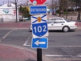
Access on the Halifax Peninsula
The 4-lane divided freeway portion of Highway 102 ends at Bayers Road in the west end of the city. Some streets on the Halifax PeninsulaHalifax Peninsula
The Halifax Peninsula is a community and planning area located in the urban core of Halifax Regional Municipality in the province of Nova Scotia. Halifax Peninsula is home to Downtown Halifax, the financial and economic heart of the region, which was also the site of the original settlement and...
are signed with Highway 102 directional markers, with the word "INBOUND" marking a path from the end of the freeway section into the downtown core, and "OUTBOUND" marking the reverse path from the same terminus in the downtown core to the start of the freeway. These streets do not appear to be officially part of Highway 102.
Nova Scotia Highway 111
Highway 111 is a 13-kilometre controlled access freeway in Nova Scotia, Canada.Highway 111 varies from 4-12 lanes and is known informally as the Dartmouth "Circumferential Highway", or, more recently, "The Circ", since it is a partial orbital road. The highway runs from Pleasant Street in the...
is provided on Connaught Avenue north from Bayers Road and the Windsor Street Exchange to the A. Murray MacKay Bridge
A. Murray MacKay Bridge
The A. Murray MacKay Bridge locally known as "the new bridge" is the second suspension bridge linking the Halifax Peninsula with Dartmouth, Nova Scotia, and opened on July 10, 1970....
.
Inbound
The "inbound" route markers are posted east on Bayers Road, south on Connaught Avenue, east on Quinpool Road, south on Bell Road, then east on Sackville Street to the intersection with Lower Water Street.Outbound
The "outbound" markers are posted beginning north on Lower Water Street, west on Cogswell Street, west on Quinpool Road, north on Connaught Avenue, west on Bayers Road.Communities served
Communities served along the highway include, from south to north:- HalifaxCity of HalifaxHalifax is a city in Canada, which was the capital of the province of Nova Scotia and shire town of Halifax County. It was the largest city in Atlantic Canada until it was amalgamated into Halifax Regional Municipality in 1996...
(the former city) - Fairview
- Clayton ParkClayton Park, Nova ScotiaClayton Park is a Canadian suburban development in Nova Scotia's Halifax Regional Municipality inside the city of Halifax.-Original development:...
- RockinghamRockingham, Nova ScotiaRockingham is a community located in Nova Scotia's Halifax Regional Municipality. It is part of a large suburban area along the western shore of Bedford Basin, north of Clayton Park and south of Bedford.-Geography:...
- BedfordBedford, Nova ScotiaBedford is a community in the Halifax Regional Municipality, Nova Scotia, Canada. It was an independent town from 1980-1996. Bedford lies on the northwestern end of Bedford Basin, an extension of the Halifax Harbour...
- Lower SackvilleLower Sackville, Nova ScotiaLower Sackville is a suburban community located in the Halifax Regional Municipality, Nova Scotia, Canada. It is part of the urban area of Halifax ....
- Fall RiverFall River, Nova ScotiaFall River is a Canadian suburban community in Nova Scotia's Halifax Regional Municipality.It is located north of the Bedford Basin, northwest of Bedford, east of Lower Sackville and north and west of Waverley....
- Halifax International AirportHalifax International AirportHalifax/Robert L. Stanfield International Airport, or Halifax Stanfield International Airport is an airport in Enfield, Nova Scotia and in Halifax Regional Municipality, Canada...
- EnfieldEnfield, Nova ScotiaEnfield, , is a Canadian exurban community located in the Shubenacadie Valley on the border of Hants and Halifax counties. Specifically, Enfield exists in both the East Hants Municipal District and the Halifax Regional Municipality and is divided by the Shubenacadie River.The history of European...
- ElmsdaleElmsdale, Nova ScotiaElmsdale is an unincorporated Canadian community located on the boundary of Hants and Halifax counties in Nova Scotia.Specifically, the community is divided by the Shubenacadie River, with the eastern half being in the Halifax Regional Municipality and the western half being in the Municipality of...
- ShubenacadieShubenacadie, Nova ScotiaShubenacadie is a community located in Hants County, in central Nova Scotia, Canada. As of 2006, the population was 2,074.In the Micmac language, Shubenacadie means "abounding in ground nuts" or "place where the red potato Shubenacadie (['ʃuːbə'nækədiː]) is a community located in Hants County, in...
- StewiackeStewiacke, Nova Scotia-External links:* *...
- BrookfieldBrookfield, Nova ScotiaBrookfield is a Canadian rural community located in southern Colchester County, Nova Scotia, Canada. Brookfield is a growing community in the heart of Nova Scotia, just forty minutes from the provincial capital of Halifax, thirty minutes from the Stanfield International Airport and ten minutes...
- Millbrook First NationMillbrook First NationThe Millbrook First Nation is a Mi'kmaq First Nation located in Nova Scotia.ReservesThe First Nation governs the following reserves:* Millbrook 27* Cole Harbour 30* Beaver Lake 17* Sheet Harbour 36* Truro 27A* Truro 27B* Truro 27CNotable residents...
- TruroTruro, Nova Scotia-Education:Truro has one high school, Cobequid Educational Centre. Post-secondary options include a campus of the Nova Scotia Community College, as well as the Nova Scotia Agricultural College in the neighboring town of Bible Hill.- Sports :...
- OnslowOnslow, Nova ScotiaOnslow is a small, unincorporated, Canadian rural community in central Colchester County, Nova Scotia. The community is located along the north bank of the Salmon River, opposite the town of Truro and is largely a farming area...
Major Intersections (Halifax)
- Connaught Avenue
- Desmond Avenue
- Joseph Howe Drive
- Northwest Arm Dr / Dunbrack Street
- Hwy 103Nova Scotia Highway 103Highway 103 is an east-west highway in Nova Scotia that runs from Halifax to Yarmouth.The highway follows a route of approximately 300 km along the province's South Shore region fronting the Atlantic coast. The route parallels its predecessor, local Trunk 3...
- Lacewood Drive / Chain Lake Drive
- Dunbrack Street / Kearney Lake Road
- Hammonds Plains Road / Bedford HighwayBedford HighwayThe Bedford Highway is a highway in the Halifax Regional Municipality , Nova Scotia that is part of Trunk 2. It runs around the western side of the Bedford Basin...
- Bedford HighwayBedford HighwayThe Bedford Highway is a highway in the Halifax Regional Municipality , Nova Scotia that is part of Trunk 2. It runs around the western side of the Bedford Basin...
- Hwy 101Nova Scotia Highway 101Highway 101 is an east-west highway in Nova Scotia that runs from Bedford to Yarmouth.The highway follows a route along the southern coast of the Bay of Fundy through the Annapolis Valley. Between its western terminus at Yarmouth to Weymouth, the highway is 2-lane controlled access. Between...
- Glendale Avenue / Duke Street
Interchanges from South to North
| Location | Exit Number | Kilometre Post* | Intersecting Roads |
|---|---|---|---|
| Halifax RM Halifax Regional Municipality, Nova Scotia Halifax Regional Municipality is the capital of the province of Nova Scotia, Canada. The Regional Municipality had a 2006 census population of 372,679, while the metropolitan area had a 2010 estimated population of 403,188, and the urban area of Halifax had a population of 282,924... (Halifax City of Halifax Halifax is a city in Canada, which was the capital of the province of Nova Scotia and shire town of Halifax County. It was the largest city in Atlantic Canada until it was amalgamated into Halifax Regional Municipality in 1996... ) |
0 | 0 | Joseph Howe Drive |
| Halifax RM | 1D | 1 | Northwest Arm Drive, Dunbrack Street |
| Halifax RM | 1A | 2 | Lighthouse Route Lighthouse Route The Lighthouse Route is a scenic roadway in the Canadian province of Nova Scotia.It follows the province's South Shore for from Halifax to Yarmouth.-Numbered:*Trunk 3*Highway 103*Route 309*Route 329*Route 330*Route 331*Route 332*Route 333... http://www.gov.ns.ca/tran/cameras/camdetails.asp?id=Beechville |
| Halifax RM | (none) | 3 | Chain Lake Drive, Bayers Lake |
| Halifax RM | 2A | 4 | Lacewood Drive, Bayers Lake |
| Halifax RM (Halifax City of Halifax Halifax is a city in Canada, which was the capital of the province of Nova Scotia and shire town of Halifax County. It was the largest city in Atlantic Canada until it was amalgamated into Halifax Regional Municipality in 1996... ) |
2 | 7 | Kearney Lake Road |
| Halifax RM (Bedford Bedford, Nova Scotia Bedford is a community in the Halifax Regional Municipality, Nova Scotia, Canada. It was an independent town from 1980-1996. Bedford lies on the northwestern end of Bedford Basin, an extension of the Halifax Harbour... ) |
2B | 10 | Larry Uteck Boulevard |
| Halifax RM (Bedford Bedford, Nova Scotia Bedford is a community in the Halifax Regional Municipality, Nova Scotia, Canada. It was an independent town from 1980-1996. Bedford lies on the northwestern end of Bedford Basin, an extension of the Halifax Harbour... ) |
(none) | 11 | (proposed freeway) |
| Halifax RM (Bedford Bedford, Nova Scotia Bedford is a community in the Halifax Regional Municipality, Nova Scotia, Canada. It was an independent town from 1980-1996. Bedford lies on the northwestern end of Bedford Basin, an extension of the Halifax Harbour... ) |
3 | 12 | Hammonds Plains Road |
| Halifax RM (Bedford Bedford, Nova Scotia Bedford is a community in the Halifax Regional Municipality, Nova Scotia, Canada. It was an independent town from 1980-1996. Bedford lies on the northwestern end of Bedford Basin, an extension of the Halifax Harbour... ) |
4A/B | 16 | / Bedford Highway  (Trunk 1/Evangeline Trail) (Lower Sackville (Trunk 1/Evangeline Trail) (Lower SackvilleLower Sackville, Nova Scotia Lower Sackville is a suburban community located in the Halifax Regional Municipality, Nova Scotia, Canada. It is part of the urban area of Halifax .... )http://www.gov.ns.ca/tran/cameras/camdetails.asp?id=Bedford |
| Halifax RM (Lower Sackville Lower Sackville, Nova Scotia Lower Sackville is a suburban community located in the Halifax Regional Municipality, Nova Scotia, Canada. It is part of the urban area of Halifax .... /Bedford Bedford, Nova Scotia Bedford is a community in the Halifax Regional Municipality, Nova Scotia, Canada. It was an independent town from 1980-1996. Bedford lies on the northwestern end of Bedford Basin, an extension of the Halifax Harbour... ) |
4C | 17 | Duke Street / Glendale Avenue |
| Halifax RM (Waverley Waverley, Nova Scotia Waverley is a community of the Halifax Regional Municipality, Nova Scotia, Canada. It is located about 20 minutes from Downtown Halifax, Nova Scotia. It has a rich history in gold mining.-History:... ) |
5 | 24 | (northbound)http://www.gov.ns.ca/tran/cameras/camdetails.asp?id=Waverley2 |
| Halifax RM (Waverley Waverley, Nova Scotia Waverley is a community of the Halifax Regional Municipality, Nova Scotia, Canada. It is located about 20 minutes from Downtown Halifax, Nova Scotia. It has a rich history in gold mining.-History:... ) |
5 | 25 | (southbound only)http://www.gov.ns.ca/tran/cameras/camdetails.asp?id=Waverley |
| Halifax RM | 5A | 31 | Aerotech Drive http://www.gov.ns.ca/tran/cameras/camdetails.asp?id=Kelly%20Lake |
| Halifax RM | 6 | 34 | Halifax International Airport Halifax International Airport Halifax/Robert L. Stanfield International Airport, or Halifax Stanfield International Airport is an airport in Enfield, Nova Scotia and in Halifax Regional Municipality, Canada... |
| Halifax RM (Enfield Enfield, Nova Scotia Enfield, , is a Canadian exurban community located in the Shubenacadie Valley on the border of Hants and Halifax counties. Specifically, Enfield exists in both the East Hants Municipal District and the Halifax Regional Municipality and is divided by the Shubenacadie River.The history of European... ) |
7 | 40 | |
| Elmsdale Elmsdale, Nova Scotia Elmsdale is an unincorporated Canadian community located on the boundary of Hants and Halifax counties in Nova Scotia.Specifically, the community is divided by the Shubenacadie River, with the eastern half being in the Halifax Regional Municipality and the western half being in the Municipality of... |
8 | 47 | |
| Milford Milford, Nova Scotia Milford, Nova Scotia could mean one of the folling communities in Nova Scotia*Milford , Nova Scotia in Annapolis County*Milford , Nova Scotia in the Halifax Regional Municipality and Hants County... |
9 | 57 | http://www.gov.ns.ca/tran/cameras/camdetails.asp?id=Milford |
| Shubenacadie Shubenacadie, Nova Scotia Shubenacadie is a community located in Hants County, in central Nova Scotia, Canada. As of 2006, the population was 2,074.In the Micmac language, Shubenacadie means "abounding in ground nuts" or "place where the red potato Shubenacadie (['ʃuːbə'nækədiː]) is a community located in Hants County, in... |
10 | 64 | |
| Stewiacke Stewiacke, Nova Scotia -External links:* *... |
11 | 70 | |
| Brookfield Brookfield, Nova Scotia Brookfield is a Canadian rural community located in southern Colchester County, Nova Scotia, Canada. Brookfield is a growing community in the heart of Nova Scotia, just forty minutes from the provincial capital of Halifax, thirty minutes from the Stanfield International Airport and ten minutes... |
12 | 84 | |
| Millbrook First Nation Millbrook First Nation The Millbrook First Nation is a Mi'kmaq First Nation located in Nova Scotia.ReservesThe First Nation governs the following reserves:* Millbrook 27* Cole Harbour 30* Beaver Lake 17* Sheet Harbour 36* Truro 27A* Truro 27B* Truro 27CNotable residents... |
13A | 93 | Treaty Trail / Tower Road |
| Truro Truro, Nova Scotia -Education:Truro has one high school, Cobequid Educational Centre. Post-secondary options include a campus of the Nova Scotia Community College, as well as the Nova Scotia Agricultural College in the neighboring town of Bible Hill.- Sports :... |
13 | 95 | Truro Heights Road |
| Truro Truro, Nova Scotia -Education:Truro has one high school, Cobequid Educational Centre. Post-secondary options include a campus of the Nova Scotia Community College, as well as the Nova Scotia Agricultural College in the neighboring town of Bible Hill.- Sports :... |
14 | 97 | South / (Robie Street)  Glooscap Trail Glooscap TrailGlooscap Trail The Glooscap Trail is a scenic roadway in the Canadian province of Nova Scotia.It is located in the central and northern part of the province around the Minas Basin and Cobequid Bay, sub-basins of the Bay of Fundy... |
| Onslow Onslow, Nova Scotia Onslow is a small, unincorporated, Canadian rural community in central Colchester County, Nova Scotia. The community is located along the north bank of the Salmon River, opposite the town of Truro and is largely a farming area... |
14A | 98 | North (northbound only) (Glooscap Trail) |
| Onslow Onslow, Nova Scotia Onslow is a small, unincorporated, Canadian rural community in central Colchester County, Nova Scotia. The community is located along the north bank of the Salmon River, opposite the town of Truro and is largely a farming area... |
15W/15E | 99 |
- *Exit numbers in Nova Scotia are sequential.