
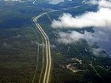
Nova Scotia Highway 118
Encyclopedia

Nova Scotia
Nova Scotia is one of Canada's three Maritime provinces and is the most populous province in Atlantic Canada. The name of the province is Latin for "New Scotland," but "Nova Scotia" is the recognized, English-language name of the province. The provincial capital is Halifax. Nova Scotia is the...
, is a short suburban freeway connecting (officially) Victoria Road via Woodland Ave. in Dartmouth
Dartmouth, Nova Scotia
Dartmouth founded in 1750, is a community and planning area of the Halifax Regional Municipality, Nova Scotia. Located on the eastern shore of Halifax Harbour, Dartmouth has been nicknamed the City of Lakes after the large number of lakes located in the city.On April 1, 1996, the provincial...
with Highway 102
Nova Scotia Highway 102
Highway 102 is a north-south freeway in the Canadian province of Nova Scotia that runs from Halifax to Truro. It is the busiest highway in Atlantic Canada....
at Fall River
Fall River, Nova Scotia
Fall River is a Canadian suburban community in Nova Scotia's Halifax Regional Municipality.It is located north of the Bedford Basin, northwest of Bedford, east of Lower Sackville and north and west of Waverley....
, 14 kilometres (8.7 mi) to the north. The highway crosses the Historic Shubenacadie Canal
Shubenacadie Canal
The Shubenacadie Canal is a Canadian canal in central Nova Scotia, linking Halifax Harbour with Shubenacadie Grand Lake which drains into the Bay of Fundy by way of the Shubenacadie River. Currently small craft use the river and lakes, but no locks are fully operational...
. Running parallel to the highway from the Waverley Road to exit 14 is a portion of the Halifax Lateral of the Maritimes & Northeast Pipeline
Maritimes & Northeast Pipeline
The Maritimes and Northeast Pipeline is a natural gas transmission pipeline that runs from the Sable Offshore Energy Project gas plant in Goldboro, Nova Scotia, Canada to Dracut, Massachusetts, United States....
(natural gas
Natural gas
Natural gas is a naturally occurring gas mixture consisting primarily of methane, typically with 0–20% higher hydrocarbons . It is found associated with other hydrocarbon fuel, in coal beds, as methane clathrates, and is an important fuel source and a major feedstock for fertilizers.Most natural...
). It also runs along the western shore of Lake Micmac
Lake Micmac
Lake Micmac is a small freshwater lake located in the Halifax Regional Municipality in Nova Scotia, Canada.Located entirely within the community of Dartmouth, Lake Micmac is also known as 'Second Lake' for its position in the Shubenacadie Canal system....
and the western edge of Shubie Park
Shubie Park
Shubie Park is a urban park in Dartmouth, Nova Scotia maintained by the Halifax Regional Municipality.Heavily forested, Shubie Park is roughly linear in shape as it is bounded on the north and west by Highway 118 expressway and on the south and east by Lake Micmac and the southern edge of Lake...
and is known as Lakeview Drive. The highway serves as a "B-Train" route between Dartmouth and Highway 102. The highway has the only Collector-express section in Atlantic Canada. It is located at the new exit 12 Dartmouth Crossing
Dartmouth Crossing
Dartmouth Crossing is a commercial real estate development currently under construction in Dartmouth, a part of Halifax Regional Municipality, Nova Scotia, Canada.-Background:...
interchange.
The south end of provincial maintenance is at the Highway 111 interchange.
History
During the early 1970s, it was decided a new highway was required to directly link Highway 102 with Dartmouth. In 1972, the then Department of Highways expropriated a portion of land for the construction of Highway 118. The highway was completed in the late 1970's .Exit list
The entire route is in the Halifax Regional MunicipalityHalifax Regional Municipality, Nova Scotia
Halifax Regional Municipality is the capital of the province of Nova Scotia, Canada. The Regional Municipality had a 2006 census population of 372,679, while the metropolitan area had a 2010 estimated population of 403,188, and the urban area of Halifax had a population of 282,924...
.
| Location | km | # Exit number An exit number is a number assigned to a road junction, usually an exit from a freeway. It is usually marked on the same sign as the destinations of the exit, as well as a sign in the gore.... |
Destinations | Notes | Coordinates |
|---|---|---|---|---|---|
| Dartmouth Dartmouth, Nova Scotia Dartmouth founded in 1750, is a community and planning area of the Halifax Regional Municipality, Nova Scotia. Located on the eastern shore of Halifax Harbour, Dartmouth has been nicknamed the City of Lakes after the large number of lakes located in the city.On April 1, 1996, the provincial... |
2 | Micmac Boulevard, Lancaster Drive | At-grade | 44°41′8.4"N 63°34′9"W | |
| 3 | *11 | , Halifax Halifax Peninsula The Halifax Peninsula is a community and planning area located in the urban core of Halifax Regional Municipality in the province of Nova Scotia. Halifax Peninsula is home to Downtown Halifax, the financial and economic heart of the region, which was also the site of the original settlement and... , Mackay Bridge |
44°41′31.4"N 63°33′45.7"W | ||
| 5 | *12 | Wright Avenue - Dartmouth Crossing Dartmouth Crossing Dartmouth Crossing is a commercial real estate development currently under construction in Dartmouth, a part of Halifax Regional Municipality, Nova Scotia, Canada.-Background:... |
44°42′26.9"N 63°33′26.2"W | ||
| 6 | *13 | Signed as exits 13E (east) and 13W (west) | 44°43′58.9"N 63°33′46.8"W | ||
| Waverley Waverley, Nova Scotia Waverley is a community of the Halifax Regional Municipality, Nova Scotia, Canada. It is located about 20 minutes from Downtown Halifax, Nova Scotia. It has a rich history in gold mining.-History:... |
13 | *14 | Northbound exit and southbound entrance | 44°48′13.2"N 63°36′1"W | |
| Fall River Fall River, Nova Scotia Fall River is a Canadian suburban community in Nova Scotia's Halifax Regional Municipality.It is located north of the Bedford Basin, northwest of Bedford, east of Lower Sackville and north and west of Waverley.... |
14 | Northbound exit and southbound entrance | 44°48′28.1"N 63°36′2"W |
- Exit 1 was used from 1971 to 2007 and renumbered Exit 11
- Exits 2 and 3 used to be a work site until construction started on Dartmouth Crossing in 2005
- Exit 4 was used until 1979, when it was renumbered to Exit 13
- Exit 5 was also used until 1979, when it was renumbered to Exit 14