

Nova Scotia Highway 104
Encyclopedia
Highway 104 in Nova Scotia
runs from the New Brunswick
border near Amherst
to St. Peter's
. Except for the portion on Cape Breton Island
between Port Hawkesbury
and St. Peter's, it is part of the Trans-Canada Highway
.
Highway 104 mostly supplants the former route of Trunk 4. In 1970, all sections of Trunk 4 west of New Glasgow were renumbered, although the number was added back in the Mount Thom and Wentworth Valley
areas in the 1990s when new alignments of Highway 104 opened to traffic.
The provincial government named the length of the highway between the New Brunswick border and the Canso Causeway the Miner's Memorial Highway on 8 September 2008 one month before the 50th anniversary of the Springhill Mining Disaster
of 23 October 1958.
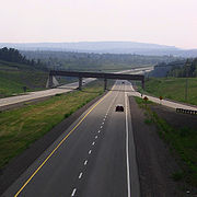 The route is 320 kilometres (198.8 mi) long, of which the western 177 km (110 mi) is a 4-lane divided freeway. From Amherst, the highway runs east to Oxford
, then southeast on a tolled section through the Cobequid Pass
that opened in 1997. Tolls for this section are $4 for cars and $3.50 per axle for commercial vehicles. It meets Highway 102
near Truro
then turns back northeast past Mount Thom
to New Glasgow
.
East of New Glasgow, the highway becomes 2 lanes and undivided, and portions have no controlled access. There are traffic lights in the Antigonish
area, although construction has begun on a four-laned bypass. This bypass will keep traffic moving at 110 km/h (70 mph), and eliminate the various bottlenecks between Antigonish and Heatherton, including stretches of road with a posted speed limit of 60 km/h (40 mph). Beginning at Heatherton
(19 km to the east), Highway 104 is a two-lane freeway
to Auld's Cove
, where several gas stations and motels are located. The highway then crosses the Canso Causeway
to Cape Breton Island. The highway is unsigned as it follows Trunk 4 through the town of Port Hawkesbury
. From there, another 37 km (23 mi) two-lane freeway segment follows the southern coast of Cape Breton Island to its end at Trunk 4 in St. Peter's. An extension of Highway 104 to Sydney
has been proposed in the past.
The Nova Scotia provincial government has designated the entire length of Highway 104 from Amherst to St. Peters as a "strategic highway" to qualify for federal cost-sharing of maintenance and future upgrades. This designation has also been applied to the remaining Trunk 4 corridor in Cape Breton along the south shore of Bras d'Or Lake
from St. Peters to Sydney. It is eventually envisioned that the Trans-Canada Highway will follow the entire length of Highway 104 from Amherst to Sydney as a 4-lane freeway, upgraded from the existing two-lane freeway and uncontrolled access sections of the highway.
, and the Canso Causeway
. The mayor of Port Hawkesbury, Billy Joe MacLean, was quoted as saying to the government of Nova Scotia
, "...if you thought you had people getting killed this year, there's more coming in 2011 and 2012. So please answer what we're asking for. Give us a date and time for completion of highway twinning." The province is currently building a bypass around the Town of Antigonish, but is not expected to be completed until 2012. In their recently released 5-year paving plan, Nova Scotia's Department of Transportation and Infrastructure Renewal has no plans to twin Highway 104 to the Canso Causeway.
Nova Scotia
Nova Scotia is one of Canada's three Maritime provinces and is the most populous province in Atlantic Canada. The name of the province is Latin for "New Scotland," but "Nova Scotia" is the recognized, English-language name of the province. The provincial capital is Halifax. Nova Scotia is the...
runs from the New Brunswick
New Brunswick
New Brunswick is one of Canada's three Maritime provinces and is the only province in the federation that is constitutionally bilingual . The provincial capital is Fredericton and Saint John is the most populous city. Greater Moncton is the largest Census Metropolitan Area...
border near Amherst
Amherst, Nova Scotia
Amherst is a Canadian town in northwestern Cumberland County, Nova Scotia.Located at the northeast end of the Cumberland Basin, an arm of the Bay of Fundy, Amherst is strategically situated on the eastern boundary of the Tantramar Marshes 3 kilometres east of the interprovincial border with New...
to St. Peter's
St. Peter's, Nova Scotia
St. Peter's is a small incorporated village located on Cape Breton Island in Richmond County, Nova Scotia, Canada....
. Except for the portion on Cape Breton Island
Cape Breton Island
Cape Breton Island is an island on the Atlantic coast of North America. It likely corresponds to the word Breton, the French demonym for Brittany....
between Port Hawkesbury
Port Hawkesbury, Nova Scotia
-Historical residents:*Henry Nicholas Paint , member of Parliament for Richmond county, merchant and land owner. His family received land grants at Belle Vue on the Strait of Canso in 1817 and at Point Tupper in 1863, and did much to develop the local communities in the area.*Arthur John Langley ...
and St. Peter's, it is part of the Trans-Canada Highway
Trans-Canada Highway
The Trans-Canada Highway is a federal-provincial highway system that joins the ten provinces of Canada. It is, along with the Trans-Siberian Highway and Australia's Highway 1, one of the world's longest national highways, with the main route spanning 8,030 km...
.
Highway 104 mostly supplants the former route of Trunk 4. In 1970, all sections of Trunk 4 west of New Glasgow were renumbered, although the number was added back in the Mount Thom and Wentworth Valley
Wentworth Valley
The Wentworth Valley is a valley in the Cobequid Hills of northwestern Nova Scotia, Canada.The valley is located in a glacial trough north of Folly Mountain and comprises the lowest elevation pass through the Cobequids...
areas in the 1990s when new alignments of Highway 104 opened to traffic.
The provincial government named the length of the highway between the New Brunswick border and the Canso Causeway the Miner's Memorial Highway on 8 September 2008 one month before the 50th anniversary of the Springhill Mining Disaster
Springhill mining disaster
The term Springhill mining disaster can refer to any of three separate Canadian mining disasters which occurred in 1891, 1956, and 1958 in different mines within the Springhill coalfield, near the town of Springhill in Cumberland County, Nova Scotia....
of 23 October 1958.
Route
Oxford, Nova Scotia
Oxford is a town in Cumberland County, Nova Scotia, Canada east of Amherst. The town is directly serviced by Routes 104, 204, 301, and 321.-History:...
, then southeast on a tolled section through the Cobequid Pass
Cobequid Pass
Cobequid Pass is the name given to a 45 kilometre toll section of Nova Scotia Highway 104 in Colchester County and Cumberland County between Masstown and Thompson Station with a toll station near Great Village...
that opened in 1997. Tolls for this section are $4 for cars and $3.50 per axle for commercial vehicles. It meets Highway 102
Nova Scotia Highway 102
Highway 102 is a north-south freeway in the Canadian province of Nova Scotia that runs from Halifax to Truro. It is the busiest highway in Atlantic Canada....
near Truro
Truro, Nova Scotia
-Education:Truro has one high school, Cobequid Educational Centre. Post-secondary options include a campus of the Nova Scotia Community College, as well as the Nova Scotia Agricultural College in the neighboring town of Bible Hill.- Sports :...
then turns back northeast past Mount Thom
Mount Thom, Nova Scotia
Mount Thom is a community in the Canadian province of Nova Scotia, located in Pictou County .-References:**...
to New Glasgow
New Glasgow, Nova Scotia
New Glasgow is a town in Pictou County, in the province of Nova Scotia, Canada. It is situated on the banks of the East River of Pictou, which flows into Pictou Harbour, a sub-basin of the Northumberland Strait....
.
East of New Glasgow, the highway becomes 2 lanes and undivided, and portions have no controlled access. There are traffic lights in the Antigonish
Antigonish, Nova Scotia
Antigonish is a Canadian town in Antigonish County, Nova Scotia. The town is home to St. Francis Xavier University and the oldest continuous highland games in North America.-History:...
area, although construction has begun on a four-laned bypass. This bypass will keep traffic moving at 110 km/h (70 mph), and eliminate the various bottlenecks between Antigonish and Heatherton, including stretches of road with a posted speed limit of 60 km/h (40 mph). Beginning at Heatherton
Heatherton, Nova Scotia
Heatherton is a small community in the Canadian province of Nova Scotia, located in Antigonish County. It has an elementry school, post office, church and Hall. Local economy consists of farming, forestry and fishing. Many people work in the town of Antigonish.-References:*...
(19 km to the east), Highway 104 is a two-lane freeway
Two-lane freeway
A two-lane expressway is an expressway with only one lane in each direction, and usually no median barrier. It may be built that way because of constraints, or may be intended for expansion once traffic volumes rise. The term super two is often used by roadgeeks for this type of road, but traffic...
to Auld's Cove
Auld's Cove, Nova Scotia
Auld's Cove is a community in the Canadian province of Nova Scotia, located in Guysborough County on Nova Scotia Highway 104 at the Canso Causeway. It is thought to have been named for Alexander Auld, an early settler who had grist and saw mills there....
, where several gas stations and motels are located. The highway then crosses the Canso Causeway
Canso Causeway
The Canso Causeway is a rock-fill causeway in Nova Scotia, Canada.The causeway crosses the Strait of Canso, connecting Cape Breton Island by road to the Nova Scotia peninsula...
to Cape Breton Island. The highway is unsigned as it follows Trunk 4 through the town of Port Hawkesbury
Port Hawkesbury, Nova Scotia
-Historical residents:*Henry Nicholas Paint , member of Parliament for Richmond county, merchant and land owner. His family received land grants at Belle Vue on the Strait of Canso in 1817 and at Point Tupper in 1863, and did much to develop the local communities in the area.*Arthur John Langley ...
. From there, another 37 km (23 mi) two-lane freeway segment follows the southern coast of Cape Breton Island to its end at Trunk 4 in St. Peter's. An extension of Highway 104 to Sydney
Sydney, Nova Scotia
Sydney is a Canadian urban community in the province of Nova Scotia. It is situated on the east coast of Cape Breton Island and is administratively part of the Cape Breton Regional Municipality....
has been proposed in the past.
The Nova Scotia provincial government has designated the entire length of Highway 104 from Amherst to St. Peters as a "strategic highway" to qualify for federal cost-sharing of maintenance and future upgrades. This designation has also been applied to the remaining Trunk 4 corridor in Cape Breton along the south shore of Bras d'Or Lake
Bras d'Or Lake
Bras d'Or Lake is a large body of salt water dominating the centre of Cape Breton Island in the province of Nova Scotia, Canada. Bras d'Or Lake is sometimes referred to as the Bras d'Or Lakes or the Bras d'Or Lakes system, however its official geographic name is Bras d'Or Lake as it is a singular...
from St. Peters to Sydney. It is eventually envisioned that the Trans-Canada Highway will follow the entire length of Highway 104 from Amherst to Sydney as a 4-lane freeway, upgraded from the existing two-lane freeway and uncontrolled access sections of the highway.
Fatal crashes prompt calls for twinning
In August 2010, 6 people were killed on the untwinned portion of Highway 104 between Sutherland's River, Nova ScotiaSutherland's River, Nova Scotia
Sutherland's River is a community in the Canadian province of Nova Scotia, located in Pictou County .-References:*...
, and the Canso Causeway
Canso Causeway
The Canso Causeway is a rock-fill causeway in Nova Scotia, Canada.The causeway crosses the Strait of Canso, connecting Cape Breton Island by road to the Nova Scotia peninsula...
. The mayor of Port Hawkesbury, Billy Joe MacLean, was quoted as saying to the government of Nova Scotia
Nova Scotia
Nova Scotia is one of Canada's three Maritime provinces and is the most populous province in Atlantic Canada. The name of the province is Latin for "New Scotland," but "Nova Scotia" is the recognized, English-language name of the province. The provincial capital is Halifax. Nova Scotia is the...
, "...if you thought you had people getting killed this year, there's more coming in 2011 and 2012. So please answer what we're asking for. Give us a date and time for completion of highway twinning." The province is currently building a bypass around the Town of Antigonish, but is not expected to be completed until 2012. In their recently released 5-year paving plan, Nova Scotia's Department of Transportation and Infrastructure Renewal has no plans to twin Highway 104 to the Canso Causeway.
Exit list
Kilometre distances are approximate.| Location | km | # Exit number An exit number is a number assigned to a road junction, usually an exit from a freeway. It is usually marked on the same sign as the destinations of the exit, as well as a sign in the gore.... |
Destinations | Notes |
|---|---|---|---|---|
| Fort Lawrence Fort Lawrence, Nova Scotia Fort Lawrence is a Canadian rural community located on the Isthmus of Chignecto in Cumberland County, Nova Scotia.Situated 1 km east of the Missaguash River which forms the inter-provincial boundary with New Brunswick, Fort Lawrence is situated on a low ridge facing Aulac to the west and... |
1 | 1 | ||
| Amherst Amherst, Nova Scotia Amherst is a Canadian town in northwestern Cumberland County, Nova Scotia.Located at the northeast end of the Cumberland Basin, an arm of the Bay of Fundy, Amherst is strategically situated on the eastern boundary of the Tantramar Marshes 3 kilometres east of the interprovincial border with New... |
5 | 3 | ||
| 7 | 4 | |||
| Springhill Springhill, Nova Scotia -Coal mining:The first industrial coal mining in the area took place in the 1870s after a rail connection was built by the Springhill and Parrsboro Coal and Railway Company to the newly completed Intercolonial Railway at neighbouring Springhill Junction.... , Salt Springs Station Salt Springs Station, Nova Scotia Salt Springs Station is a small community in the Canadian province of Nova Scotia, located near Amherst.-References:*... |
30 | 5 | ||
| Oxford Oxford, Nova Scotia Oxford is a town in Cumberland County, Nova Scotia, Canada east of Amherst. The town is directly serviced by Routes 104, 204, 301, and 321.-History:... |
40 | 6 | ||
| Thompson Station Thompson Station, Nova Scotia Thomson Station is a small community in the Canadian province of Nova Scotia, located in Cumberland County.-References:*... |
49 | 7 | ||
| Westchester Valley Westchester Valley, Nova Scotia Westchester Valley is a small community in the Canadian province of Nova Scotia, located in Cumberland County.-References:*... |
59 | 8 | ||
| Great Village Great Village, Nova Scotia Great Village is a community of approximately 500 people located along Trunk 2 and the north shore of Cobequid Bay in Colchester County Nova Scotia... |
83 | 10 | ||
| Glenholme Glenholme, Nova Scotia Glenholme is a community in the Canadian province of Nova Scotia, located in Colchester County .-References:*... |
89 | 11 | , Wentworth Wentworth, Nova Scotia Wentworth is a small Canadian rural community located in the Wentworth Valley of Nova Scotia.The community takes in the following hamlets:* Lower Wentworth* Wentworth Centre* Wentworth Station* Wentworth Valley... |
|
| Masstown Masstown, Nova Scotia Masstown is a farming community located approximately 17 kilometers from Truro, Nova Scotia.-Historic background:Masstown has its beginnings with French settlers, known as Acadians. They first settled in this area near the Cobequid Bay in 1705. The Acadian culture consisted primarily of farming... |
93 | 12 | West end of Trunk 4 overlap | |
| Lower Onslow Lower Onslow, Nova Scotia Lower Onslow is a small community in the Canadian province of Nova Scotia, located in Colchester County.-References:*... , Debert Debert, Nova Scotia Debert is an unincorporated farming community in the Canadian province of Nova Scotia. It is located approximately 20 km west of the town of Truro. The Village of Debert is home to two churches, Baptist and United, plus a Fellowship Center, as well as a gas station and two garages. There are... |
98 | 13 | Debert Debert, Nova Scotia Debert is an unincorporated farming community in the Canadian province of Nova Scotia. It is located approximately 20 km west of the town of Truro. The Village of Debert is home to two churches, Baptist and United, plus a Fellowship Center, as well as a gas station and two garages. There are... , Lower Onslow Lower Onslow, Nova Scotia Lower Onslow is a small community in the Canadian province of Nova Scotia, located in Colchester County.-References:*... |
|
| Truro Truro, Nova Scotia -Education:Truro has one high school, Cobequid Educational Centre. Post-secondary options include a campus of the Nova Scotia Community College, as well as the Nova Scotia Agricultural College in the neighboring town of Bible Hill.- Sports :... |
107 | 15 | Only exit to Halifax | |
| Valley Valley, Nova Scotia Valley is a community in the Canadian province of Nova Scotia, located in Colchester County. There is a school located there called Valley Elementary School, and right across the road there is a convenience store called 'Valley Variety'. Next door to the school is the Valley United... |
116 | 17 | East end of Trunk 4 overlap | |
| Kemptown Kemptown, Nova Scotia Kemptown is a community in the Canadian province of Nova Scotia, located in Colchester County .-References:*... |
126 | 18 | Stevens Cross Road - Kemptown Kemptown, Nova Scotia Kemptown is a community in the Canadian province of Nova Scotia, located in Colchester County .-References:*... , Riversdale Riversdale ,Colchester, Nova Scotia Riversdale is a community in the Canadian province of Nova Scotia, located in Colchester County.-References:*... |
|
| Mount Thom Mount Thom, Nova Scotia Mount Thom is a community in the Canadian province of Nova Scotia, located in Pictou County .-References:**... |
133 | 18A | ||
| Salt Springs Salt Springs, Nova Scotia Salt Springs is a small Canadian rural community located in the central-western part of Pictou County, Nova Scotia.-Geography:The community shares a valley with the upper reaches of the West River , with the surrounding mountains being the eastern extension of the Cobequid Hills... |
146 | 19 | Route 376 Nova Scotia Route 376 Route 376 is a collector road in the Canadian province of Nova Scotia.It is located in Pictou County and connects West River at Trunk 4 with Pictou at Highway 106. It was originally part of Trunk 6 until 1970-Communities:*West River*Durham*Lyons Brook... - |
|
| Alma Alma, Nova Scotia Alma is a community in the Canadian province of Nova Scotia, located in Pictou County. The Nova Scotia Highway 104, now Nova Scotia Trunk 4 formerly ran through the community until the highway got bypassed.-References:*... |
155 | 20 | ||
| Westville | 159 | 21 | West end of Trunk 4 overlap | |
| Mount William Mount William, Nova Scotia Mount William is a small community in the Canadian province of Nova Scotia, located in Pictou County.-References:*... |
161 | 22 | , P.E.I. Ferry Northumberland Ferries Limited Northumberland Ferries Limited is a ferry company operating in eastern Canada and headquartered in Charlottetown, Prince Edward Island... |
|
| New Glasgow New Glasgow, Nova Scotia New Glasgow is a town in Pictou County, in the province of Nova Scotia, Canada. It is situated on the banks of the East River of Pictou, which flows into Pictou Harbour, a sub-basin of the Northumberland Strait.... |
164 | 23 | ||
| New Glasgow New Glasgow, Nova Scotia New Glasgow is a town in Pictou County, in the province of Nova Scotia, Canada. It is situated on the banks of the East River of Pictou, which flows into Pictou Harbour, a sub-basin of the Northumberland Strait.... , Stellarton Stellarton, Nova Scotia -External links:*... |
165 | 24 | Route 374 Nova Scotia Route 374 Route 374 is a collector road in the Canadian province of Nova Scotia. It connects New Glasgow at Exit 24 of Highway 104 with Sheet Harbour at Trunk 7.-Communities :*New Glasgow*Stellarton*Riverton*Eureka*Hopewell*Lorne*Trafalgar*Lochaber Mines... - New Glasgow New Glasgow, Nova Scotia New Glasgow is a town in Pictou County, in the province of Nova Scotia, Canada. It is situated on the banks of the East River of Pictou, which flows into Pictou Harbour, a sub-basin of the Northumberland Strait.... , Stellarton Stellarton, Nova Scotia -External links:*... , Trenton Trenton, Nova Scotia Trenton is a town located in Pictou County, Nova Scotia.Trenton is situated on the east bank of the East River of Pictou, adjacent to and immediately north of the larger town of New Glasgow.- Economy :... |
|
| New Glasgow New Glasgow, Nova Scotia New Glasgow is a town in Pictou County, in the province of Nova Scotia, Canada. It is situated on the banks of the East River of Pictou, which flows into Pictou Harbour, a sub-basin of the Northumberland Strait.... , Plymouth Plymouth, Pictou County, Nova Scotia Plymouth is a small Canadian rural community in Pictou County, Nova Scotia located approximately 3 km south of the town of New Glasgow. It stretches along Route 348 situated on the east bank of the East River of Pictou, opposite the town of Stellarton.... |
167 | 25 | Route 348 Nova Scotia Route 348 Route 348 is a collector road in the Canadian province of Nova Scotia.It is located in the northeastern part of the province and connects Little Harbour at Route 289 with Melrose at Trunk 7.... - East River Road, Trunk 4 New Glasgow New Glasgow, Nova Scotia New Glasgow is a town in Pictou County, in the province of Nova Scotia, Canada. It is situated on the banks of the East River of Pictou, which flows into Pictou Harbour, a sub-basin of the Northumberland Strait.... , Stellarton Stellarton, Nova Scotia -External links:*... , Trenton Trenton, Nova Scotia Trenton is a town located in Pictou County, Nova Scotia.Trenton is situated on the east bank of the East River of Pictou, adjacent to and immediately north of the larger town of New Glasgow.- Economy :... |
|
| Thorburn Thorburn, Nova Scotia Thorburn is a community in the Canadian province of Nova Scotia, located in Pictou County.- The Community :This small rural Nova Scotia town has a hair salon, sports arena, a few churches, a fire hall and a pizza and convenience store called Pete's Pizza. Thorburn is a quiet town and has... |
170 | 26 | Route 348 Nova Scotia Route 348 Route 348 is a collector road in the Canadian province of Nova Scotia.It is located in the northeastern part of the province and connects Little Harbour at Route 289 with Melrose at Trunk 7.... - to |
|
| Sutherlands River | 178 | 27A | West end of Trunk 4 overlap; at-grade | |
| 179 | 27 | Route 245 Nova Scotia Route 245 Route 245 is a collector road in the Canadian province of Nova Scotia.The route spans Pictou and Antigonish counties and connects Sutherlands River at Exit 27 on Highway 104 with Antigonish at Trunk 4.-Communities:*Sutherlands River*Egerton*Merigomish... |
East end of Trunk 4 overlap; at-grade | |
| Lower Barney's River Lower Barney's River, Nova Scotia Lower Barney's River is a small community in the Canadian province of Nova Scotia, located in Pictou County.-References:*... |
198 | 29 | West end of Trunk 4 overlap; at-grade | |
| Marshy Hope Marshy Hope, Nova Scotia Marshy Hope is a community in the Canadian province of Nova Scotia, located in Pictou County .-References:**... |
204 | East end of Trunk 4 overlap; at-grade | ||
| James River James River, Nova Scotia James River is a community in the Canadian province of Nova Scotia, located in Antigonish County.-References:*... |
210 | 30 | ||
| West River West River, Nova Scotia West River is a community in the Canadian province of Nova Scotia, located in Pictou County .-References:*... |
219 | 31A | West end of Trunk 4 overlap; at-grade | |
| Antigonish Antigonish, Nova Scotia Antigonish is a Canadian town in Antigonish County, Nova Scotia. The town is home to St. Francis Xavier University and the oldest continuous highland games in North America.-History:... |
221 | 31 | East end of Trunk 4 overlap; at-grade | |
| 222 | 32 | At-grade | ||
| 223 | 33 | Church Street | At-grade | |
| Greenwold Greenwold, Nova Scotia Greenwold is a small community in the Canadian province of Nova Scotia, located in Antigonish County.-References:*... |
226 | 34 | West end of Trunk 4 overlap; at-grade | |
| Lower South River Lower South River, Nova Scotia Lower South River is a community in the Canadian province of Nova Scotia, located in Antigonish County. Home of legendary Dr John Hugh Gillis High School quarterback Marcus MacIntyre. Lower South River residents are not known as partiers but are famous for bonfires at "The Pit".-References:*... |
230 | 35 | Route 316 Nova Scotia Route 316 Route 316 is a collector road in the Canadian province of Nova Scotia.It is located in Antigonish County and Guysborough County, connecting Lower South River at Highway 104 with Half Island Cove at Trunk 16.-Communities:*Half Island Cove*Upper Whitehead... At-grade |
|
| Heatherton Heatherton, Nova Scotia Heatherton is a small community in the Canadian province of Nova Scotia, located in Antigonish County. It has an elementry school, post office, church and Hall. Local economy consists of farming, forestry and fishing. Many people work in the town of Antigonish.-References:*... |
238 | 36 | Summerside Road | At-grade |
| 240 | 36A | East end of Trunk 4 overlap; at-grade | ||
| Monastery Monastery, Nova Scotia Monastery is a small community in the Canadian province of Nova Scotia, located in Antigonish County at the junction of Nova Scotia Trunk 16 and 4.-References:***... |
252 | 37 | ||
| Havre Boucher Havre Boucher, Nova Scotia Havre Boucher is a Canadian village in Antigonish County, Nova Scotia.The village takes its name from "Havre Boucher", a natural harbour that opens onto St. George's Bay to the north... |
262 | 38 | Havre Boucher Havre Boucher, Nova Scotia Havre Boucher is a Canadian village in Antigonish County, Nova Scotia.The village takes its name from "Havre Boucher", a natural harbour that opens onto St. George's Bay to the north... , Frankville Frankville, Nova Scotia Frankville is a small community in the Canadian province of Nova Scotia, located in Antigonish County.-References:*... , Linwood Linwood, Nova Scotia Linwood is a community in the Canadian province of Nova Scotia, located in Antigonish County.Linwood, Nova Scotia is a small coastal community located half way between the town of Antigonish and the Canso Causeway. Located around Linwood Harbour, it is a great swimming and boating location... |
|
| Auld's Cove Auld's Cove, Nova Scotia Auld's Cove is a community in the Canadian province of Nova Scotia, located in Guysborough County on Nova Scotia Highway 104 at the Canso Causeway. It is thought to have been named for Alexander Auld, an early settler who had grist and saw mills there.... |
270 | 39 | West end of Trunk 4 overlap; at-grade | |
| 271 | 40 | Route 344 Nova Scotia Route 344 Route 344 is a collector road in the Canadian province of Nova Scotia.It is located in Guysborough County and connects Auld's Cove at Trunk 4 with Boylston at Trunk 16.-Communities:*Auld's Cove*Mulgrave*Pirate Harbour*Steep Creek*Middle Melford... |
At-grade | |
| Port Hastings Port Hastings, Nova Scotia Port Hastings is a Canadian rural community in Inverness County, Nova Scotia.The community is located at the eastern end of the Canso Causeway on Cape Breton Island.-History:The community was previously known as Plaster Cove.... |
274 | 41 | Signs Used As Exit 1 Instead |
Port Hawkesbury - St. Peter's section
| Location | Exit | km | Intersecting Roads | Notes |
|---|---|---|---|---|
| Port Hawkesbury Port Hawkesbury, Nova Scotia -Historical residents:*Henry Nicholas Paint , member of Parliament for Richmond county, merchant and land owner. His family received land grants at Belle Vue on the Strait of Canso in 1817 and at Point Tupper in 1863, and did much to develop the local communities in the area.*Arthur John Langley ... |
43 | 283 |  Trunk 4 Trunk 4 |
|
| Lower River Inhabitants Lower River Inhabitants, Nova Scotia Lower River Inhabitants is a small community in the Canadian province of Nova Scotia, located in Richmond County.-References:*... |
44 | 293 | Lower River Road, Port Malcolm Road | at-grade |
| Evanston Evanston, Nova Scotia Evanston is a small community in the Canadian province of Nova Scotia, located in Richmond County on Cape Breton Island .-References:*... |
45 | 295 | Evanston Road, Whiteside Road | at-grade |
| Louisdale Louisdale, Nova Scotia Louisdale is a Canadian rural community in Richmond County, Nova Scotia. The community is located on Cape Breton Island at the centre of a French-Acadian region. Founded mainly by families from nearby Petit-de-Grat, its early settlers were primarily of Acadian and, from the early 19th century,... |
46 | 306 | Route 320 Nova Scotia Route 320 Route 320 is a collector road in the Canadian province of Nova Scotia.It is located in Richmond County and connects Louisdale at Exit 26 on Highway 104 with Arichat at Route 206 .... |
|
| River Bourgeois River Bourgeois, Nova Scotia River Bourgeois is a small community in the Canadian province of Nova Scotia, located in Richmond County on Cape Breton Island. Canadian writers and activists, Farley Mowat, and his wife, Claire, have their summer home there. It is the hometown of former NHL player Mike McPhee. His father still... |
47 | 316 | Sporting Mountain Road | |
| St. Peter's St. Peter's, Nova Scotia St. Peter's is a small incorporated village located on Cape Breton Island in Richmond County, Nova Scotia, Canada.... |
- | - | Trunk 4 |
at-grade |