

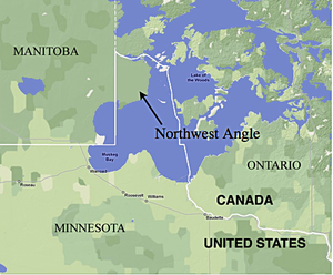
Northwest Angle
Encyclopedia
Angle Township, Lake of the Woods County, Minnesota
Angle Township is a township in Lake of the Woods County, Minnesota, United States. The population was 119 at the 2010 census. At 49.22° north latitude, it is the northernmost township in Minnesota and the northernmost point in the contiguous 48 states...
, is a part of northern Lake of the Woods County, Minnesota
Lake of the Woods County, Minnesota
Lake of the Woods County is a county located in the U.S. state of Minnesota. As of 2010, the population was 4,045. Its county seat is Baudette. The county contains the Northwest Angle, the northernmost point of the Lower 48 States, and includes the U.S. portion of Lake of the Woods, shared with...
, and is the only place in the United States
United States
The United States of America is a federal constitutional republic comprising fifty states and a federal district...
outside Alaska
Alaska
Alaska is the largest state in the United States by area. It is situated in the northwest extremity of the North American continent, with Canada to the east, the Arctic Ocean to the north, and the Pacific Ocean to the west and south, with Russia further west across the Bering Strait...
that is north of the 49th parallel
49th parallel north
The 49th parallel north is a circle of latitude that is 49 degrees north of the Earth's equatorial plane. It crosses Europe, Asia, the Pacific Ocean, North America, and the Atlantic Ocean....
. That parallel is the northern boundary of the 48 contiguous states extending from the west coast along the northern boundaries of Washington, Idaho
Idaho
Idaho is a state in the Rocky Mountain area of the United States. The state's largest city and capital is Boise. Residents are called "Idahoans". Idaho was admitted to the Union on July 3, 1890, as the 43rd state....
, Montana
Montana
Montana is a state in the Western United States. The western third of Montana contains numerous mountain ranges. Smaller, "island ranges" are found in the central third of the state, for a total of 77 named ranges of the Rocky Mountains. This geographical fact is reflected in the state's name,...
, North Dakota
North Dakota
North Dakota is a state located in the Midwestern region of the United States of America, along the Canadian border. The state is bordered by Canada to the north, Minnesota to the east, South Dakota to the south and Montana to the west. North Dakota is the 19th-largest state by area in the U.S....
, and part of Minnesota
Minnesota
Minnesota is a U.S. state located in the Midwestern United States. The twelfth largest state of the U.S., it is the twenty-first most populous, with 5.3 million residents. Minnesota was carved out of the eastern half of the Minnesota Territory and admitted to the Union as the thirty-second state...
to the Northwest Angle. The Angle is one of only four non-island locations in the 48 contiguous states not directly connected to them by land within the country, the others being nearby Elm Point, Minnesota
Elm Point, Minnesota
Elm Point, Minnesota, in Lake of the Woods County, Minnesota, is a small cape and a United States practical exclave, southwest of the Northwest Angle...
; Point Roberts, Washington
Point Roberts, Washington
Point Roberts is an unincorporated community in Whatcom County, Washington, United States. It has a post office, with the ZIP code of 98281, whose ZIP Code Tabulation Area had a population of 1,314 at the 2010 census.A geopolitical oddity, Point Roberts is a part of the United States that is not...
; and the town of Alburgh, Vermont
Alburgh (town), Vermont
Alburgh is a town in Grand Isle County, Vermont, United States, founded in 1781 by Ira Allen. The population was 1,952 at the 2000 census...
. All four are located along the US-Canada border.
Farther east, U.S. territory does not extend as far north as the 49th parallel. Map projection
Map projection
A map projection is any method of representing the surface of a sphere or other three-dimensional body on a plane. Map projections are necessary for creating maps. All map projections distort the surface in some fashion...
s sometimes create a superficial appearance that Maine
Maine
Maine is a state in the New England region of the northeastern United States, bordered by the Atlantic Ocean to the east and south, New Hampshire to the west, and the Canadian provinces of Quebec to the northwest and New Brunswick to the northeast. Maine is both the northernmost and easternmost...
extends farther north than that; that appearance does not occur in maps in which parallels of latitude
Latitude
In geography, the latitude of a location on the Earth is the angular distance of that location south or north of the Equator. The latitude is an angle, and is usually measured in degrees . The equator has a latitude of 0°, the North pole has a latitude of 90° north , and the South pole has a...
are straight lines.
A portion (70%) of the Angle is held in trust by the Red Lake Indian Reservation
Red Lake Indian Reservation
The Red Lake Indian Reservation covers 1,258.62 sq mi in parts of nine counties in northern Minnesota, United States. It is divided into many pieces, although the largest piece is centered about Red Lake, in north-central Minnesota, the largest lake entirely within that state. This section lies...
(Ojibwa
Ojibwa
The Ojibwe or Chippewa are among the largest groups of Native Americans–First Nations north of Mexico. They are divided between Canada and the United States. In Canada, they are the third-largest population among First Nations, surpassed only by Cree and Inuit...
).
Although the Angle is listed as one of several distinct regions of Minnesota, its total population was only 152 at the 2000 census.
Origin
The Treaty of ParisTreaty of Paris (1783)
The Treaty of Paris, signed on September 3, 1783, ended the American Revolutionary War between Great Britain on the one hand and the United States of America and its allies on the other. The other combatant nations, France, Spain and the Dutch Republic had separate agreements; for details of...
, concluded between the United States and Great Britain
Kingdom of Great Britain
The former Kingdom of Great Britain, sometimes described as the 'United Kingdom of Great Britain', That the Two Kingdoms of Scotland and England, shall upon the 1st May next ensuing the date hereof, and forever after, be United into One Kingdom by the Name of GREAT BRITAIN. was a sovereign...
at the end of the American Revolutionary War
American Revolutionary War
The American Revolutionary War , the American War of Independence, or simply the Revolutionary War, began as a war between the Kingdom of Great Britain and thirteen British colonies in North America, and ended in a global war between several European great powers.The war was the result of the...
, stated that the boundary between U.S. territory and the British possessions to the north would run "...through the Lake of the Woods to the northwestern most point
Northwestern point of the Lake of the Woods
The northwestern point of the Lake of the Woods was a critical landmark for the boundary between U.S. territory and the British possessions to the north. This point was used in the Treaty of Paris in 1783 and in later treaties including the Treaty of 1818. This point lies at the corner of the...
thereof, and from thence on a due west course to the river Mississippi
Mississippi River
The Mississippi River is the largest river system in North America. Flowing entirely in the United States, this river rises in western Minnesota and meanders slowly southwards for to the Mississippi River Delta at the Gulf of Mexico. With its many tributaries, the Mississippi's watershed drains...
..."
The parties did not suspect that the source of the Mississippi, Lake Itasca
Lake Itasca
Lake Itasca is a small glacial lake, approximately in area, in the Headwaters area of north central Minnesota. The lake is located in southeastern Clearwater County within Itasca State Park and it has an average depth of 20–35 feet , and is 1,475 ft above sea level.The Ojibwe name for...
(then unknown to European explorers), was south of that point, and that thus the entire Mississippi was too far south to be intersected by a line running west from the Lake of the Woods. A factor in this mistake was the use of the Mitchell Map
Mitchell Map
The Mitchell Map is a map made by John Mitchell , which was reprinted several times during the second half of the 18th century. The Mitchell Map was used as a primary map source during the Treaty of Paris for defining the boundaries of the newly independent United States...
during the treaty negotiations; that map showed the Mississippi extending far to the north. In the Anglo-American Convention of 1818, the error was corrected by having the boundary run directly from the northwest point of the lake to the 49th parallel
49th parallel north
The 49th parallel north is a circle of latitude that is 49 degrees north of the Earth's equatorial plane. It crosses Europe, Asia, the Pacific Ocean, North America, and the Atlantic Ocean....
and then westward along it.
When a survey team led by David Thompson
David Thompson (explorer)
David Thompson was an English-Canadian fur trader, surveyor, and map-maker, known to some native peoples as "Koo-Koo-Sint" or "the Stargazer"...
finally located the northwesternmost point of the lake and surveyed this north-south line, it was found to intersect other bays of the lake and therefore form the boundary of a section of U.S. territory to its east, now known as the Northwest Angle.
Geography
United States Census Bureau
The United States Census Bureau is the government agency that is responsible for the United States Census. It also gathers other national demographic and economic data...
, Angle Township has a total area of 596.3 square miles (1,544.5 km2) of which 123.09 square miles (318.81 km2) is land and 473.2 square miles (1,225.7 km2) (79.36%) is water. The land includes several islands, including Oak Island, and two small capes that are below (south of) the 49th parallel north
49th parallel north
The 49th parallel north is a circle of latitude that is 49 degrees north of the Earth's equatorial plane. It crosses Europe, Asia, the Pacific Ocean, North America, and the Atlantic Ocean....
in the extreme southwest part of the township, south of the southeast corner of Manitoba
Manitoba
Manitoba is a Canadian prairie province with an area of . The province has over 110,000 lakes and has a largely continental climate because of its flat topography. Agriculture, mostly concentrated in the fertile southern and western parts of the province, is vital to the province's economy; other...
, and not far from the northeast corner of Roseau County
Roseau County, Minnesota
Roseau County is a county located in the state of Minnesota, United States. As of 2010, the population was 15,629. Its county seat is Roseau.-Geography:...
. Of the 2000 census
United States Census, 2000
The Twenty-second United States Census, known as Census 2000 and conducted by the Census Bureau, determined the resident population of the United States on April 1, 2000, to be 281,421,906, an increase of 13.2% over the 248,709,873 persons enumerated during the 1990 Census...
population of 152, there were 118 living on the mainland, and 34 persons on the islands in Lake of the Woods
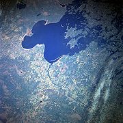
Lake of the Woods
Lake of the Woods is a lake occupying parts of the Canadian provinces of Ontario and Manitoba and the U.S. state of Minnesota. It separates a small land area of Minnesota from the rest of the United States. The Northwest Angle and the town of Angle Township can only be reached from the rest of...
. All of the populated islands are north of the 49th parallel.
The mainland portion of the township north of the 49th parallel has an area of 116.632 square miles (302.1 km²). The total land area of all islands is 6.303 square miles (16.3 km²), and the two capes total 100 acre (0.156250138152179 sq mi; 40.47 ha). The township has the last one-room public school
One-room school
One-room schools were commonplace throughout rural portions of various countries including the United States, Canada, Australia, New Zealand, United Kingdom, Ireland and Spain in the late 19th and early 20th centuries. In most rural and small town schools, all of the students met in a single room...
in the state.
Elm Point
Elm Point, Minnesota
Elm Point, Minnesota, in Lake of the Woods County, Minnesota, is a small cape and a United States practical exclave, southwest of the Northwest Angle...
, in Lake of the Woods County, is a small cape southwest of the Northwest Angle. It borders Canada and is, together with a similar smaller cape to the west, separated by land from the continental United States.
Access
The Angle is accessible from the rest of Minnesota by one of two ways:- One can reach the angle without crossing the international border by crossing the Lake of the WoodsLake of the WoodsLake of the Woods is a lake occupying parts of the Canadian provinces of Ontario and Manitoba and the U.S. state of Minnesota. It separates a small land area of Minnesota from the rest of the United States. The Northwest Angle and the town of Angle Township can only be reached from the rest of...
. This can be done by aircraft, by boat when the lake is free of ice, or by ice roadIce roadIce roads are frozen, human-made structures on the surface of bays, rivers, lakes, or seas in the far north. They link dry land, frozen waterways, portages and winter roads, and are usually remade each winter. Ice roads allow temporary transport to areas with no permanent road access...
in the winter. Since there are no automobile ferries currently operating on the lake, vehicles coming from the rest of Minnesota can reach the Angle without crossing the border only in winter. While the ice is forming in late autumn and breaking up in the spring the lake's surface cannot be crossed safely – at these times domestic access to the Angle is possible only by air.
- To reach the Angle over land, one would take Minnesota State Highway 313N (Warroad, MinnesotaWarroad, MinnesotaAs of the census of 2000, there were 1,722 people, 657 households, and 419 families residing in the city. The population density was . There were 766 housing units at an average density of . The racial makeup of the city was 81.65% White, 0.29% Black or African American, 7.38% Native American,...
to Sprague, ManitobaSprague, ManitobaSprague is a community in the Canadian province of Manitoba minutes from Minnesota and Ontario. It is located in the Rural Municipality of Piney, about one hour south of Steinbach and two hours south of Winnipeg. It is a small town located at the junctions of Highway 308 and Highway 12....
) across the border into Manitoba, Canada, connecting to Provincial Road 12 in Manitoba at the border, then to Provincial Road 308 Manitoba, to Provincial Road 525, then finally crossing back into the United States in the Northwest Angle south of rural developed Angle Inlet, Minnesota (Angle Inlet Township). The distance from Warroad or RoseauRoseau, MinnesotaAs of the census of 2000, there were 2,756 people, 1,157 households, and 713 families residing in the city. The population density was 1,153.6 people per square mile . There were 1,229 housing units at an average density of 514.4 per square mile...
to the Angle proper is approximately 63 miles through Minnesota and Manitoba back to the Angle's U.S. border. It is approximately 10 miles from the actual border (intersection of Manitoba #525 and NWA Road Dawson) to the rural developments of the Northwest Angle.
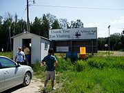
The border crossing (image)
is unstaffed. Travelers using the single gravel road in and out of the Angle are expected to use a telephone at Jim's Corner, Youngs Bay Marina or Carlsons Landing to contact Canadian
Canada Border Services Agency
The Canada Border Services Agency is a federal law enforcement agency that is responsible for border enforcement, immigration enforcement and customs services....
or U.S. Customs
U.S. Customs and Border Protection
U.S. Customs and Border Protection is a federal law enforcement agency of the United States Department of Homeland Security charged with regulating and facilitating international trade, collecting import duties, and enforcing U.S. regulations, including trade, customs and immigration. CBP is the...
and make their declarations.
Politics and popular culture
Because of laws restricting fishing, some residents of the Northwest Angle suggested leaving the United States and joining Canada in 1997. The following year, U.S. RepresentativeUnited States House of Representatives
The United States House of Representatives is one of the two Houses of the United States Congress, the bicameral legislature which also includes the Senate.The composition and powers of the House are established in Article One of the Constitution...
Collin Peterson
Collin Peterson
Collin Clark Peterson , is the U.S. Representative for , serving since 1991, and the ranking member of the House Agriculture Committee. He is a member of the Democratic-Farmer-Labor Party and is the dean of the Minnesota congressional delegation.The district, Minnesota's largest and most rural...
proposed a constitutional amendment that would allow the residents of the Northwest Angle, which is part of his district, to vote on seceding from the United States and joining Canada, angering the leaders of Red Lake Indian Reservation
Red Lake Indian Reservation
The Red Lake Indian Reservation covers 1,258.62 sq mi in parts of nine counties in northern Minnesota, United States. It is divided into many pieces, although the largest piece is centered about Red Lake, in north-central Minnesota, the largest lake entirely within that state. This section lies...
, which holds most of the Northwest Angle's land. This proposed Amendment was introduced to bring equity (under NAFTA) to alleged irregularities in the ways differing nationalities were treated on the Canadian portion of Lake of the Woods. US fishermen were not allowed to keep any gamefish caught in Ontario, unless they were actually staying at Canadian lodging facilities. This was later repealed by Ontario officials once a court action was initiated.
Author Tim O'Brien
Tim O'Brien (author)
Tim O'Brien is an American novelist who often writes about his experiences in the Vietnam War and the impact the war had on the American servicemen who fought there...
popularized knowledge of the location with his bestselling novel In the Lake of the Woods
In the Lake of the Woods
In the Lake of the Woods is a novel by Tim O'Brien, author of Pulitzer Prize-nominated The Things They Carried. An example of O'Brien's recurring Vietnam War theme, In the Lake of the Woods follows the struggle of John Wade to deal with a recently failed campaign for the United States Senate...
, set in the Angle.
The Danny Orlis series
Danny Orlis Series
Danny Orlis is a Christian fiction series for youth by American author Bernard Palmer and published predominantly by Moody Press of Chicago. Created in 1954, for many years the series was a regular feature on the weekly Back to the Bible radio broadcasts for youth in the 1950s–1980s...
of books, a Christian fiction series for youth, were largely set in the Northwest Angle.
The Northwest Angle was noted by host Brian Unger
Brian Unger
Brian Unger is an American actor, comedian, writer, producer, and commentator.-Biography:Born in Granville, Ohio in a family with Romanian ethnic heritage, Unger graduated from Ohio University in 1987, where he majored in communication...
in the History Channel documentary How the States Got Their Shapes
How the States Got Their Shapes
How the States Got Their Shapes is a television series that airs on the History channel. It is hosted by Brian Unger and is based on Mark Stein's book, How the States Got Their Shapes. The show deals with how the various states of the United States established their borders, but also delves into...
, as a "blip on the top of Minnesota that was the result of treaties long ago".
Ernie Pyle
Ernie Pyle
Ernest Taylor Pyle was an American journalist who wrote as a roving correspondent for the Scripps Howard newspaper chain from 1935 until his death in combat during World War II. He won the Pulitzer Prize in 1944...
, in his book Home Country, wrote several pages about the Northwest Angle and its residents.
William Kent Krueger
William Kent Krueger
William Kent Krueger is a multi award-winning American author and crime writer, best known for his Cork O'Connor series of books, which is mainly set in Minnesota. USA...
's 2011 novel Northwest Angle takes place in the area.
See also
- Border irregularities of the United StatesBorder irregularities of the United StatesBorder irregularities of the United States, particularly panhandles, territory effectively an exclave because of water, and highway incursions into other states, are not uncommon. Often they are a result of geometric borders not following geological features...
- Extreme points of the United StatesExtreme points of the United StatesThis is a list of the extreme points of the United States, the points that are farther north, south, east, or west than any other location in the country. Also included are extreme points in elevation, extreme distances, and other points of peculiar geographic interest.-Northernmost:*Point Barrow,...
- Height of Land Portage
External links
- The Lost Canadians In depth reportage by Grant Stoddart. The WalrusThe WalrusThe Walrus is a Canadian general interest magazine which publishes long form journalism on Canadian and international affairs, along with fiction and poetry by Canadian writers. It launched in September 2003, as an attempt to create a Canadian equivalent to American magazines such as Harper's, The...
, December 15, 2010. - Angle Inlet School: Minnesota's last one-room school
- The Northwest Angle (radio programme transcript)
- Boundary Commission Coordinates
- To the Nub An account of an RV trip to Northwest Angle from Washington, DC
- Northwest Angle Trip Report Visit to the extreme northernmost point of the Angle.