

North Carolina Councils of Governments
Encyclopedia
The North Carolina Councils of Government are voluntary associations of county and municipal
governments, established by the North Carolina General Assembly
in 1972.
Originally numbering 18, the 17 current regional associations handle services which are generally more economic to coordinate on a regional, rather than local level, including economic development, environmental protection, land-use planning, and services for the elderly.
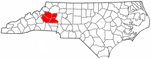
Region A Southwestern Commission
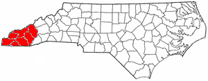
Cherokee
, Clay
, Graham
, Swain
, Haywood
, Jackson
, Macon
Region B: Land-of-Sky Regional Council
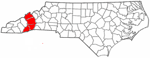
Madison
, Buncombe
, Henderson
, Transylvania
Region C: Isothermal Planning and Development Commission
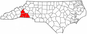
Polk
, Rutherford
, McDowell
, Cleveland
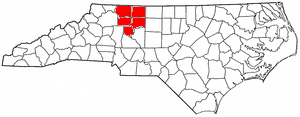
Region D: High Country Council of Governments
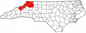
Yancey
, Mitchell
, Avery
, Watauga
, Ashe
, Alleghany
, Wilkes
Region E: Western Piedmont Council of Governments
Caldwell
, Burke
, Alexander
, Catawba
Region F: Centralina Council of Governments
Iredell
, Rowan
, Lincoln
, Gaston
, Mecklenburg
, Cabarrus
, Stanly
, Union
, Anson
Region G: Piedmont Triad Council of Governments
Davidson
, Montgomery
, Randolph
, Guilford
, Rockingham
, Caswell
, Alamance
Region I: Northwest Piedmont Council of Governments
Surry
, Stokes
, Forsyth
, Yadkin
, Davie
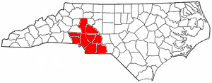
Region J: Triangle J Council of Governments
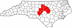
Moore
, Lee
, Chatham
, Orange
, Durham
, Wake
, Johnston
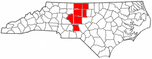
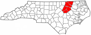
Region K: Kerr-Tar Regional Council of Governments
Person
, Granville
, Vance
, Warren
, Franklin
Region L: Upper Coastal Plain Council of Governments
Wilson
, Nash
, Edgecombe
, Halifax
, Northampton
Region M: Mid-Carolina Council of Governments
Harnett
, Cumberland
, Sampson
Region N: Lumber River Council of Governments
Richmond
, Scotland
, Hoke
, Robeson
, Bladen
Region O: Cape Fear Council of Governments
Brunswick
, Columbus
, New Hanover
, Pender
Region P: Eastern Carolina Council of Governments
Onslow
, Duplin
, Wayne
, Greene
, Lenoir
, Jones
, Craven
, Carteret
, Pamlico
Region Q: Mid-East Commission
Hertford
, Bertie
, Martin
, Pitt
, Beaufort
Region R: Albemarle Commission

Gates
, Chowan
, Perquimans
, Pasquotank
, Camden
, Currituck
, Washington
, Tyrrell
, Dare
, Hyde
Municipality
A municipality is essentially an urban administrative division having corporate status and usually powers of self-government. It can also be used to mean the governing body of a municipality. A municipality is a general-purpose administrative subdivision, as opposed to a special-purpose district...
governments, established by the North Carolina General Assembly
North Carolina General Assembly
The North Carolina General Assembly is the state legislature of the U.S. state of North Carolina. The General Assembly drafts and legislates the state laws of North Carolina, also known as the General Statutes...
in 1972.
Originally numbering 18, the 17 current regional associations handle services which are generally more economic to coordinate on a regional, rather than local level, including economic development, environmental protection, land-use planning, and services for the elderly.
Region A Southwestern CommissionSouthwestern CommissionThe Southwestern North Carolina Planning and Economic Development Commission, also known as the Southwestern Commission, is one of the 17 regional North Carolina Councils of Government...
Cherokee
Cherokee County, North Carolina
- Transportation :Cherokee County is well known in North Carolina as the westernmost of the state's 100 counties. Several US and state highways serve the county, linking it with other regions of North Carolina, along with the neighboring states of Georgia and Tennessee.US 64 - the longest highway...
, Clay
Clay County, North Carolina
-Communities and Townships:Hayesville, with a 2000 population of 297, is the only incorporated town in the county, the county seat, and center of economic activity for Clay County...
, Graham
Graham County, North Carolina
-Demographics:As of the census of 2000, there were 7,993 people, 3,354 households, and 2,411 families residing in the county. The population density was 27 people per square mile . There were 5,084 housing units at an average density of 17 per square mile...
, Swain
Swain County, North Carolina
Swain County is a county located in the U.S. state of North Carolina. As of 2000, the population was 12,968. Its county seat is Bryson City.Swain County is home of the Nantahala River . The Nantahala is one of the most popular whitewater rafting rivers in the nation...
, Haywood
Haywood County, North Carolina
-National protected areas:* Blue Ridge Parkway * Great Smoky Mountains National Park * Pisgah National Forest -Major Highways & Roads:* Interstate 40* U.S. Highway 19* U.S. Highway 23* U.S. Highway 74* U.S...
, Jackson
Jackson County, North Carolina
Jackson County is a county located in the southwest of the U.S. state of North Carolina. As of 2010, the population was 40,271. Since 1913 its county seat has been Sylva, replacing Webster.-History:...
, Macon
Macon County, North Carolina
- Geographic features :Of the in Macon County, are federal lands that lie within the Nantahala National Forest and are administered by the United States Forest Service. Of the of USFS land, lie in the Highlands Ranger District and the remaining lie in the Wayah Ranger District...
Region B: Land-of-Sky Regional CouncilLand-of-Sky Regional CouncilThe Land-of-Sky Regional Council is one of the 17 regional North Carolina Councils of Governments established by the North Carolina General Assembly for the purpose of regional planning and administration. Headquartered in Asheville, North Carolina, it serves Madison, Buncombe, Henderson, and...
Madison
Madison County, North Carolina
-Demographics:As of the census of 2000, there were 19,635 people, 8,000 households, and 5,592 families residing in the county. The population density was 44 people per square mile . There were 9,722 housing units at an average density of 22 per square mile...
, Buncombe
Buncombe County, North Carolina
-Demographics:As of the census of 2000, there were 206,330 people, 85,776 households, and 55,668 families residing in the county. The population density was 314 people per square mile . There were 93,973 housing units at an average density of 143 per square mile...
, Henderson
Henderson County, North Carolina
Henderson County is a county located in the U.S. state of North Carolina. It is part of the Asheville, North Carolina, Metropolitan Statistical Area. As of 2008, the population was 102,367. Its county seat is Hendersonville.- History :...
, Transylvania
Transylvania County, North Carolina
Transylvania County is a county located in the U.S. state of North Carolina. As of 2010, the population was 33,090. Its county seat is Brevard.- History :The county was formed in 1861 from parts of Henderson County and Jackson County...
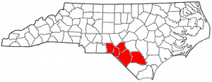
Region C: Isothermal Planning and Development CommissionIsothermal Planning and Development CommissionThe Isothermal Planning and Development Commission is one of the 17 regional North Carolina Councils of Governments established by the North Carolina General Assembly for the purpose of regional planning and administration. Headquartered in Rutherfordton, North Carolina, it serves Polk,...
Polk
Polk County, North Carolina
Polk County is a county located in the U.S. state of North Carolina. As of 2010, the population was 20,510. Its county seat is Columbus.-History:The county was formed in 1855 from parts of Henderson County and Rutherford County...
, Rutherford
Rutherford County, North Carolina
-Demographics:As of the census of 2000, there were 62,899 people, 25,191 households, and 17,935 families residing in the county. The population density was 112 people per square mile . There were 29,535 housing units at an average density of 52 per square mile...
, McDowell
McDowell County, North Carolina
-Cities and towns:*Marion *Old Fort-Unincorporated places:*West Marion*Little Switzerland*Nebo*Glenwood*Pleasant Gardens*North Cove-Education:The following is a list of schools located in McDowell County:*Marion Elementary School...
, Cleveland
Cleveland County, North Carolina
-Demographics:As of the census of 2010, there were 98,078 people, 37,046 households, and 27,006 families residing in the county. The population density was 207 people per square mile . There were 40,317 housing units at an average density of 87 per square mile...
Region D: High Country Council of GovernmentsHigh Country Council of GovernmentsThe High Country Council of Governments is one of the 17 regional North Carolina Councils of Governments established by the North Carolina General Assembly for the purpose of regional planning and administration. Headquartered in Boone, North Carolina, it serves Yancey, Mitchell, Avery, Watauga,...
Yancey
Yancey County, North Carolina
-Demographics:As of the census of 2000, there were 17,774 people, 7,472 households, and 5,372 families residing in the county. The population density was 57 people per square mile . There were 9,729 housing units at an average density of 31 per square mile...
, Mitchell
Mitchell County, North Carolina
-National protected areas:* Blue Ridge Parkway * Pisgah National Forest -Demographics:As of the census of 2000, there were 15,687 people, 6,551 households, and 4,736 families residing in the county. The population density was 71 people per square mile . There were 7,919 housing units at an...
, Avery
Avery County, North Carolina
- Climate :As a result of its relatively high elevation, Avery County has a Humid continental climate enjoying considerably cooler summers than most of the rest of the Eastern US. Likewise, winters are longer, colder and snowier than most other locations in the region. This can be evidenced by the...
, Watauga
Watauga County, North Carolina
-Demographics:As of the census of 2000, there were 42,695 people, 16,540 households, and 9,411 families residing in the county. The population density was 137 people per square mile . There were 23,155 housing units at an average density of 74 per square mile...
, Ashe
Ashe County, North Carolina
- History :Historical evidence shows that Ashe county was inhabited by Native Americans, which included the Cherokee, Creek, and Shawnee tribes. Pieces of broken pottery, arrowheads, and other Native American artifacts have been found, indicating their presence...
, Alleghany
Alleghany County, North Carolina
-Major highways:* U.S. Highway 21* U.S. Highway 221* North Carolina Highway 18* North Carolina Highway 88* North Carolina Highway 93* North Carolina Highway 113-Demographics:...
, Wilkes
Wilkes County, North Carolina
Wilkes County is a county located in the U.S. state of North Carolina. The 2000 U.S. Census listed the county's population at 65,632; the 2010 U.S. Census listed the population at 69,340...
Region E: Western Piedmont Council of GovernmentsWestern Piedmont Council of GovernmentsThe Western Piedmont Council of Governments is one of the 17 regional North Carolina Councils of Governments established by the North Carolina General Assembly for the purpose of regional planning and administration. Headquartered in Hickory, North Carolina, it serves Caldwell, Burke, Alexander,...
Caldwell
Caldwell County, North Carolina
-Demographics:As of the census of 2000, there were 77,415 people, 30,768 households, and 22,399 families residing in the county. The population density was 164 people per square mile . There were 33,430 housing units at an average density of 71 per square mile...
, Burke
Burke County, North Carolina
-Demographics:As of the census of 2000, there were 89,148 people, 34,528 households, and 24,342 families residing in the county. The population density was 176 people per square mile . There were 37,427 housing units at an average density of 74 per square mile...
, Alexander
Alexander County, North Carolina
-Demographics:As of the census of 2000, there were 33,603 people, 13,137 households, and 9,747 families residing in the county. The population density was 129 people per square mile . There were 14,098 housing units at an average density of 54 per square mile...
, Catawba
Catawba County, North Carolina
-Demographics:As of the census of 2010, there were 160,000 people, 55,533 households, and 39,095 families residing in the county. The population density was 354 people per square mile . There were 59,919 housing units at an average density of 150 per square mile...
Region F: Centralina Council of GovernmentsCentralina Council of GovernmentsThe Centralina Council of Governments is one of the 17 regional North Carolina Councils of Governments established by the North Carolina General Assembly for the purpose of regional planning and administration. Headquartered in Charlotte, North Carolina, it serves Iredell, Rowan, Lincoln, Gaston,...
Iredell
Iredell County, North Carolina
Iredell County, along with Moore County in the eastern Piedmont, are among a very few counties in the United States sharing borders with nine adjacent counties.-Demographics:...
, Rowan
Rowan County, North Carolina
-Demographics and economics:As of the census of 2010, there were 138,428 people, 53,140 households, and 37,058 families residing in the county. The population density was 270.7 people per square mile . There were 60,211 housing units at an average density of 117.7 per square mile...
, Lincoln
Lincoln County, North Carolina
-Demographics:As of the census of 2010, there were 71,498 people, 24,041 households, and 18,174 families residing in the county. The population density was 214 people per square mile . There were 25,717 housing units at an average density of 86 per square mile...
, Gaston
Gaston County, North Carolina
Gaston County is a county located just west of Charlotte in the southern Piedmont in the U.S. state of North Carolina. It is the third largest county, by population, in the Charlotte Metropolitan Area, officially designated the Charlotte-Gastonia-Concord Metropolitan Statistical Area . As of...
, Mecklenburg
Mecklenburg County, North Carolina
-Air:The county's primary commercial aviation airport is Charlotte Douglas International Airport in Charlotte.- Intercity rail :With twenty-five freight trains a day, Mecklenburg is a freight railroad transportation center, largely due to its place on the NS main line between Washington and Atlanta...
, Cabarrus
Cabarrus County, North Carolina
-Demographics:As of the census of 2000, there were 131,063 people, 49,519 households, and 36,545 families residing in the county. The population density was 360 people per square mile . There were 52,848 housing units at an average density of 145 per square mile...
, Stanly
Stanly County, North Carolina
-Demographics:As of the census of 2010, there were 60,585 people. In 2000 there were 22,223 households, and 16,156 families residing in the county. The population density was 147 people per square mile . There were 24,582 housing units at an average density of 62 per square mile...
, Union
Union County, North Carolina
-Demographics:As of the census of 2000, there were 123,677 people, 43,390 households, and 34,278 families residing in the county. The population density was 194 people per square mile . There were 45,695 housing units at an average density of 72 per square mile...
, Anson
Anson County, North Carolina
-See also:*National Register of Historic Places listings in Anson County, North Carolina-External links:*...
Region G: Piedmont Triad Council of GovernmentsPiedmont Triad Council of GovernmentsThe Piedmont Triad Council of Governments is one of the 17 regional North Carolina Councils of Governments established by the North Carolina General Assembly for the purpose of regional planning and administration...
Davidson
Davidson County, North Carolina
-Demographics:As of the census of 2010, there were 149,331 people, 58,156 households, and 42,512 families residing in the county. The population density was 267 people per square mile . There were 62,432 housing units at an average density of 113 per square mile...
, Montgomery
Montgomery County, North Carolina
-Demographics:As of the census of 2000, there were 26,822 people, 9,848 households, and 7,189 families residing in the county. The population density was 55 people per square mile . There were 14,145 housing units at an average density of 29 per square mile...
, Randolph
Randolph County, North Carolina
-Notable people:*Naomi Wise, murder victim*Richard Petty - Nascar driver.*Lee Petty - Nascar pioneer. Richard Petty's father.*Kyle Petty - Nascar driver. Son of Richard Petty*Adam Petty - Nascar driver. Kyle Petty's son...
, Guilford
Guilford County, North Carolina
Guilford County is a county located in the U.S. state of North Carolina. In 2010, the Census Bureau estimated the county's population to be 491,230. Its seat is Greensboro. Since 1938, an additional county court has been located in High Point, North Carolina, making Guilford one of only a handful...
, Rockingham
Rockingham County, North Carolina
Rockingham County is a county located in the U.S. state of North Carolina. As of 2010, the population was 93,643. Its county seat is Wentworth.- History :The county was formed in 1785 from Guilford County...
, Caswell
Caswell County, North Carolina
-Demographics:As of the census of 2000, there were 23,501 people, 8,670 households, and 6,398 families residing in the county. The population density was 55 people per square mile . There were 9,601 housing units at an average density of 23 per square mile...
, Alamance
Alamance County, North Carolina
Alamance County is a county located in the U.S. state of North Carolina. It coincides with the Burlington, North Carolina, Metropolitan Statistical Area...
Region I: Northwest Piedmont Council of GovernmentsNorthwest Piedmont Council of GovernmentsThe Northwest Piedmont Council of Governments is one of the 17 regional North Carolina Councils of Governments established by the North Carolina General Assembly for the purpose of regional planning and administration. Headquartered in Winston-Salem, North Carolina, it serves Surry, Stokes,...
Surry
Surry County, North Carolina
Surry County is a county located in the U.S. state of North Carolina. As of 2010, the population was 73,673. Its county seat is Dobson.- History :The county was formed in 1771 from Rowan County...
, Stokes
Stokes County, North Carolina
-Demographics:As of the census of 2000, there were 44,711 people, 17,579 households, and 13,043 families residing in the county. The population density was 99 people per square mile . There were 19,262 housing units at an average density of 43 per square mile...
, Forsyth
Forsyth County, North Carolina
-Demographics:As of the census of 2000, there were 306,067 people, 123,851 households, and 81,741 families residing in the county. The population density was 747 people per square mile . There were 133,093 housing units at an average density of 325 per square mile...
, Yadkin
Yadkin County, North Carolina
- Cities and towns :*Boonville*East Bend*Jonesville*Yadkinville-Towns of the past:These towns were incorporated at one time:*Arlington, merged with Jonesville in 2001.*Hamptonville, chartered in 1818.*Huntsville, incorporated in 1792....
, Davie
Davie County, North Carolina
- Wine region :Portions of Davie County are located in the Yadkin Valley AVA, an American Viticultural Area. Wines made from grapes grown in the Yadkin Valley AVA may use the appellation Yadkin Valley on their labels.-Demographics:...
Region J: Triangle J Council of GovernmentsTriangle J Council of GovernmentsThe Triangle J Council of Governments is one of the 17 regional North Carolina Councils of Governments established by the North Carolina General Assembly for the purpose of regional planning and administration...
Moore
Moore County, North Carolina
Moore County is a county located in the U.S. state of North Carolina. As of 2000, the population was 74,769. Its county seat is Carthage.- History :The county was formed in 1784 from Cumberland County...
, Lee
Lee County, North Carolina
-Demographics:As of the census of 2000, there were 49,040 people, 18,466 households, and 13,369 families residing in the county. The population density was 191 people per square mile . There were 19,909 housing units at an average density of 77 per square mile...
, Chatham
Chatham County, North Carolina
Chatham County is a county located in the Piedmont area of the U.S. state of North Carolina. As of 2000, the population was 49,329. Its county seat is Pittsboro.-History:...
, Orange
Orange County, North Carolina
Orange County is a county located in the U.S. state of North Carolina. As of the 2010 census, the population was 133,801. Its county seat is Hillsborough...
, Durham
Durham County, North Carolina
-Demographics:As of the census of 2000, there were 223,314 people, 89,015 households, and 54,032 families residing in the county. The population density was 769 people per square mile . There were 95,452 housing units at an average density of 329 per square mile...
, Wake
Wake County, North Carolina
Wake County is a county located in the U.S. state of North Carolina. As of the 2010 census, the population was 900,993 making it North Carolina's second most populated county...
, Johnston
Johnston County, North Carolina
-Major highways:* Interstate 40* Interstate 95* U.S. Highway 70* U.S. Highway 301* U.S. Highway 701-Demographics:As of the census of 2000, there were 121,965 people, 46,595 households, and 33,688 families residing in the county. The population density was 154 people per square mile . There were...
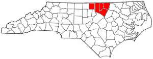
Region K: Kerr-Tar Regional Council of GovernmentsKerr-Tar Regional Council of GovernmentsThe Kerr-Tar Regional Council of Governments is one of the 17 regional North Carolina Councils of Governments established by the North Carolina General Assembly for the purpose of regional planning and administration. Headquartered in Henderson, North Carolina, it serves Person, Granville, Vance,...
Person
Person County, North Carolina
Person County is a county located in the Piedmont region in north-central North Carolina in the United States. It is part of the Durham-Chapel Hill Metropolitan Area. The population was 39,464 at the 2010 census.The county seat is Roxboro...
, Granville
Granville County, North Carolina
-Demographics:As of the census of 2010, there were 59,916 people in 20,628 households residing in the county. The population density was 111.6 people per square mile . There were 22,827 housing units at an average density of 42.5 per square mile...
, Vance
Vance County, North Carolina
-Demographics:As of the census of 2000, there were 42,954 people, 16,199 households, and 11,647 families residing in the county. The population density was 169 people per square mile . There were 18,196 housing units at an average density of 72 per square mile...
, Warren
Warren County, North Carolina
-Demographics:As of the census of 2000, there were 19,972 people, 7,708 households, and 5,449 families residing in the county. The population density was 47 people per square mile . There were 10,548 housing units at an average density of 25 per square mile...
, Franklin
Franklin County, North Carolina
-Demographics:As of the census of 2000, there were 47,260 people, 17,843 households, and 12,882 families residing in the county. The population density was 96 people per square mile . There were 20,364 housing units at an average density of 41 per square mile...
Region L: Upper Coastal Plain Council of GovernmentsUpper Coastal Plain Council of GovernmentsThe Upper Coastal Plain Council of Governments is one of the 17 regional North Carolina Councils of Governments established by the North Carolina General Assembly for the purpose of regional planning and administration...
Wilson
Wilson County, North Carolina
-Demographics:As of the census of 2006, there 73,814 people, 28,613 households, and 19,771 families residing in the county. The population density was 199 people per square mile . There were 30,729 housing units at an average density of 83 per square mile...
, Nash
Nash County, North Carolina
Nash County is a county located in the U.S. state of North Carolina. It is part of the Rocky Mount, North Carolina, Metropolitan Statistical Area. As of 2000, the population was 87,420. Its county seat is Nashville.- History :...
, Edgecombe
Edgecombe County, North Carolina
-Demographics:As of the census of 2000, there were 55,606 people, 20,392 households, and 14,804 families residing in the county. The population density was 110 people per square mile . There were 24,002 housing units at an average density of 48 per square mile...
, Halifax
Halifax County, North Carolina
-Demographics:-Demographics:-Demographics:-Demographics:-Demographics:-Demographics:-Demographics:-Demographics:-Demographics:[[Image:HalifaxCountyCotton.wmg.jpg|left|thumb|A cotton field blooms in Halifax County....
, Northampton
Northampton County, North Carolina
-Demographics:As of the census of 2000, there were 22,086 people, 8,691 households, and 5,953 families residing in the county. The population density was 41 people per square mile . There were 10,455 housing units at an average density of 20 per square mile...
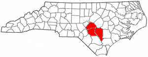
Region M: Mid-Carolina Council of GovernmentsMid-Carolina Council of GovernmentsThe Mid-Carolina Council of Governments is one of the 17 regional North Carolina Councils of Governments established by the North Carolina General Assembly for the purpose of regional planning and administration. Headquartered in Fayetteville, North Carolina, it serves Harnett, Cumberland, and...
Harnett
Harnett County, North Carolina
-Demographics:As of the census of 2000, there were 91,025 people, 33,800 households, and 24,099 families residing in the county. The population density was 153 people per square mile . There were 38,605 housing units at an average density of 65 per square mile...
, Cumberland
Cumberland County, North Carolina
-Demographics:As of the census of 2000, there were 302,963 people, 107,358 households, and 77,619 families residing in the county. The population density was 464 people per square mile . There were 118,425 housing units at an average density of 181 per square mile...
, Sampson
Sampson County, North Carolina
-Demographics:As of the census of 2010, there were 63,431 people, 22,624 households, and 16,214 families residing in the county. The population density was 67.1 people per square mile . There were 26,476 housing units at an average density of 27 per square mile...
Region N: Lumber River Council of GovernmentsLumber River Council of GovernmentsThe Lumber River Council Of Governments is one of the 17 regional North Carolina Councils of Governments established by the North Carolina General Assembly for the purpose of regional planning and administration. Headquartered in Lumberton, North Carolina, it serves Richmond, Scotland, Hoke,...
Richmond
Richmond County, North Carolina
-Demographics:As of the census of 2000, there were 46,564 people, 17,873 households, and 12,582 families residing in the county. The population density was 98 people per square mile . There were 19,886 housing units at an average density of 42 per square mile...
, Scotland
Scotland County, North Carolina
-Demographics:As of the census of 2000, there were 35,998 people, 13,399 households, and 9,674 families residing in the county. The population density was 113 people per square mile . There were 14,693 housing units at an average density of 46 per square mile...
, Hoke
Hoke County, North Carolina
-Demographics:As of the census of 2010, there were 46,952 people, 11,373 households, and 8,745 families residing in the county. The population density was 86 people per square mile . There were 12,518 housing units at an average density of 32 per square mile...
, Robeson
Robeson County, North Carolina
Robeson County is a county in the U.S. state of North Carolina. As of 2010 it had a population of 134,168. Since then, it has been one of the 10% of United States counties that were majority-minority; its combined population of American Indian, African American and Latino residents comprise over...
, Bladen
Bladen County, North Carolina
-Demographics:As of the census of 2000, there were 32,278 people, 12,897 households, and 8,937 families residing in the county. The population density was 37 people per square mile . There were 15,316 housing units at an average density of 18 per square mile...
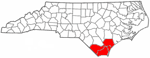
Region O: Cape Fear Council of GovernmentsCape Fear Council of GovernmentsThe Cape Fear Council of Governments is one of the 17 regional North Carolina Councils of Governments established by the North Carolina General Assembly for the purpose of regional planning and administration. Headquartered in Wilmington, North Carolina, it serves Brunswick, Columbus, New Hanover,...
Brunswick
Brunswick County, North Carolina
-External links:*******....
, Columbus
Columbus County, North Carolina
-Demographics:As of the census of 2000, there were 54,749 people, 21,308 households, and 15,043 families residing in the county. The population density was 58/sq mi . As of 2004, there were 24,668 housing units at an average density of 26/sq mi...
, New Hanover
New Hanover County, North Carolina
-Demographics:As of the census of 2000, there were 160,307 people, 68,183 households, and 41,591 families residing in the county. The population density was 806 people per square mile . There were 79,616 housing units at an average density of 400 per square mile...
, Pender
Pender County, North Carolina
-Demographics:As of the census of 2000, there were 41,082 people, 16,054 households, and 11,719 families residing in the county. The population density was 47 people per square mile . There were 20,798 housing units at an average density of 24 per square mile...
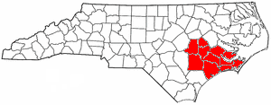
Region P: Eastern Carolina Council of GovernmentsEastern Carolina Council of GovernmentsThe Eastern Carolina Council of Governments is one of the 17 regional North Carolina Councils of Governments established by the North Carolina General Assembly for the purpose of regional planning and administration. Headquartered in New Bern, North Carolina, it serves Onslow, Duplin, Wayne,...
Onslow
Onslow County, North Carolina
-Demographics:As of the census of 2000, there were 150,355 people, 48,122 households, and 36,572 families residing in the county. The population density was 196 people per square mile . There were 55,726 housing units at an average density of 73 per square mile...
, Duplin
Duplin County, North Carolina
-Demographics:As of the census of 2000, there were 49,063 people, 18,267 households, and 13,060 families residing in the county. The population density was 60 people per square mile . There were 20,520 housing units at an average density of 25 per square mile...
, Wayne
Wayne County, North Carolina
- Cities and towns :*Brogden*Dudley*Elroy*Eureka*Fremont*Goldsboro*Mar-Mac*Mount Olive*Pikeville*Rosewood*Seven Springs*Walnut Creek*Grantham-Geography:According to the U.S...
, Greene
Greene County, North Carolina
-Demographics:As of the census of 2000, there were 18,974 people, 6,696 households, and 4,955 families residing in the county. The population density was 72 people per square mile . There were 7,368 housing units at an average density of 28 per square mile...
, Lenoir
Lenoir County, North Carolina
-Demographics:As of 2005, there were 57,961 people, 23,862 households, and 16,178 families residing in the county. The population density was 149.2 people per square mile . There were 27,940 housing units at an average density of 68 per square mile...
, Jones
Jones County, North Carolina
-Demographics:As of the census of 2000, there were 10,381 people, 4,061 households, and 2,936 families residing in the county. The population density was 22 people per square mile . There were 4,679 housing units at an average density of 10 per square mile...
, Craven
Craven County, North Carolina
Craven County is a county located in the U.S. state of North Carolina. The estimated population in 2006 was 94,875. Its county seat is New Bern.Craven County is part of the New Bern, North Carolina, Micropolitan Statistical Area.-History:...
, Carteret
Carteret County, North Carolina
Carteret County is a county located in the U.S. state of North Carolina. As of 2010, the population was 66,469. Its county seat is Beaufort. Most of the county is part of the Crystal Coast....
, Pamlico
Pamlico County, North Carolina
-Demographics:As of the census of 2000, there were 12,934 people, 5,178 households, and 3,717 families residing in the county. The population density was 38 people per square mile . There were 6,781 housing units at an average density of 20 per square mile...
Region Q: Mid-East CommissionMid-East CommissionThe Mid-East Commission is one of the 17 regional North Carolina Councils of Governments established by the North Carolina General Assembly for the purpose of regional planning and administration. Headquartered in Washington, it serves Hertford, Bertie, Martin, Pitt, and Beaufort counties....
Hertford
Hertford County, North Carolina
-Townships:The county is divided into six townships:Ahoskie, Como, Harrellsville, Murfreesboro, St. Johns and Winton.-Towns:*Ahoskie*Cofield*Como*Harrellsville*Murfreesboro*Winton-Demographics:...
, Bertie
Bertie County, North Carolina
-External links:**...
, Martin
Martin County, North Carolina
-Politics:Martin County has tended to vote in line with the rest of the country in presidential elections. In 2008, Barack Obama won the county with 52.2% of the vote. This was very similar to his national figure of 52.91%.-Demographics:...
, Pitt
Pitt County, North Carolina
-Demographics:As of the census of 2000, there were 133,798 people, 52,539 households, and 32,258 families residing in the county. The population density was 205 people per square mile . There were 58,408 housing units at an average density of 90 per square mile...
, Beaufort
Beaufort County, North Carolina
- Law and government :Beaufort County is a member of the Mid-East Commission regional council of governments.Beaufort County is one of the proposed sites for a Navy outlying landing field. This practice airfield would allow pilots to simulate landings on an aircraft carrier...
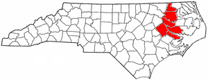
Region R: Albemarle CommissionAlbemarle CommissionThe Albemarble Commission is one of the 17 regional North Carolina Councils of Governments established by the North Carolina General Assembly for the purpose of regional planning and administration. Headquartered in Hertford, North Carolina, it serves Chowan, Currituck, Gates, Pasquotank,...
Gates
Gates County, North Carolina
Gates County is a small rural county located in the U.S. state of North Carolina. As of 2010, the population was 12,197. Its county seat is Gatesville. It is part of the Albemarle Sound area of the Inner Banks...
, Chowan
Chowan County, North Carolina
- Law and government :Chowan County is a member of the Albemarle Commission regional council of government-Demographics:As of the census of 2010, there were 14,793 people, 5,580 households, and 4,006 families residing in the county. The population density was 84 people per square mile . There...
, Perquimans
Perquimans County, North Carolina
-Demographics:As of the census of 2010, there were 13,453 people, 4,645 households, and 3,376 families residing in the county. The population density was 46 people per square mile . There were 6,043 housing units at an average density of 24 per square mile...
, Pasquotank
Pasquotank County, North Carolina
-Demographics:As of the census of 2010, there were 40,661 people, 13,907 households, and 9,687 families residing in the county. The population density was 154 people per square mile . There were 14,289 housing units at an average density of 63 per square mile...
, Camden
Camden County, North Carolina
-Schools:There are five schools in Camden County: Grandy Primary School, Camden Intermediate School, Camden Middle School, Camden County High School, and CamTech High School. However one other former school lies in Shiloh. It was a community school for the Shiloh area. The school is now home to a...
, Currituck
Currituck County, North Carolina
-National protected areas:*Currituck National Wildlife Refuge*Mackay Island National Wildlife Refuge -Demographics:As of the census of 2010, there were 23,547 people, 6,902 households, and 5,204 families residing in the county. The population density was 70 people per square mile . There were...
, Washington
Washington County, North Carolina
-Demographics:As of the census of 2000, there were 13,723 people, 5,367 households, and 3,907 families residing in the county. The population density was 39 people per square mile . There were 6,174 housing units at an average density of 18 per square mile...
, Tyrrell
Tyrrell County, North Carolina
-Demographics:Tyrrell County was as of 2000 the least populous county in North Carolina.As of the census of 2000, there were 4,149 people, 1,537 households, and 1,055 families residing in the county. The population density was 11 people per square mile . There were 2,032 housing units at an...
, Dare
Dare County, North Carolina
-National protected areas:* Alligator River National Wildlife Refuge * Cape Hatteras National Seashore * Fort Raleigh National Historic Site* Pea Island National Wildlife Refuge* Wright Brothers National Memorial-Demographics:...
, Hyde
Hyde County, North Carolina
-National protected areas:* Alligator River National Wildlife Refuge * Cape Hatteras National Seashore * Mattamuskeet National Wildlife Refuge* Pocosin Lakes National Wildlife Refuge * Swanquarter National Wildlife Refuge-Demographics:...