
Newry, Maine
Encyclopedia
Newry is a town
in Oxford County
, Maine
, United States
. The population was 344 at the 2000 census
. Newry is the home of Sunday River Ski Resort
and has a proportionately large seasonal (winter) population.
, Massachusetts
, together with Ithiel Smith of Cape Elizabeth
. But the settlement was plundered in 1782 by Indians
and abandoned. Then John J. Holmes of New Jersey
purchased the land in 1794 with his sister's surname on the deed: Bostwick. On June 15, 1805, Bostwick Plantation was renamed by settlers that had come from Newry
in what is now Northern Ireland
.
The trade route (now Route 26
) from Portland
to Errol
, New Hampshire
, completed in 1802, passed through Newry. Farms were established on the intervales, which had excellent soil. Hay
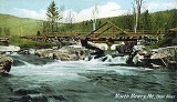
was the principal crop. Slopes of the mountains provided pasturage for grazing animals. A sawmill
and gristmill
were built on the Bear River, and by 1870 the population was 416. Today, Newry is noted as the home of Sunday River Ski Resort
.
, the town has a total area of 61.4 square miles (159 km²), of which, 61.4 square miles (159 km²) of it is land and 0.04 square mile (0.1035995244 km²) of it (0.05%) is water. Newry is drained by the Bear River
and Sunday River
, which both flow into the Androscoggin River
.
of 2000, there were 344 people, 142 households, and 90 families residing in the town. The population density
was 5.6 people per square mile (2.2/km²). There were 1,075 housing units at an average density of 17.5 per square mile (6.8/km²). The racial makeup of the town was 98.26% White, 0.87% Native American, 0.29% Asian, and 0.58% from two or more races.
There were 142 households out of which 30.3% had children under the age of 18 living with them, 50.0% were married couples
living together, 5.6% had a female householder with no husband present, and 36.6% were non-families. 23.9% of all households were made up of individuals and 4.9% had someone living alone who was 65 years of age or older. The average household size was 2.42 and the average family size was 2.96.
 In the town the population was spread out with 25.0% under the age of 18, 7.8% from 18 to 24, 25.9% from 25 to 44, 30.5% from 45 to 64, and 10.8% who were 65 years of age or older. The median age was 41 years. For every 100 females there were 108.5 males. For every 100 females age 18 and over, there were 111.5 males.
The median income for a household in the town was $42,321, and the median income for a family was $51,250. Males had a median income of $37,500 versus $19,625 for females. The per capita income
for the town was $21,982. About 3.8% of families and 5.0% of the population were below the poverty line, including 2.2% of those under age 18 and 12.5% of those age 65 or over.
New England town
The New England town is the basic unit of local government in each of the six New England states. Without a direct counterpart in most other U.S. states, New England towns are conceptually similar to civil townships in other states, but are incorporated, possessing powers like cities in other...
in Oxford County
Oxford County, Maine
Oxford County is a county located in the U.S. state of Maine with a population of 57,833 as of the 2010 U.S. census. Its county seat is Paris.Part of Oxford County is included in the Lewiston-Auburn, Maine, metropolitan New England City and Town Area while a different part of Oxford County is...
, Maine
Maine
Maine is a state in the New England region of the northeastern United States, bordered by the Atlantic Ocean to the east and south, New Hampshire to the west, and the Canadian provinces of Quebec to the northwest and New Brunswick to the northeast. Maine is both the northernmost and easternmost...
, United States
United States
The United States of America is a federal constitutional republic comprising fifty states and a federal district...
. The population was 344 at the 2000 census
United States Census, 2000
The Twenty-second United States Census, known as Census 2000 and conducted by the Census Bureau, determined the resident population of the United States on April 1, 2000, to be 281,421,906, an increase of 13.2% over the 248,709,873 persons enumerated during the 1990 Census...
. Newry is the home of Sunday River Ski Resort
Sunday River (ski resort)
Sunday River is a ski resort located in Newry, Maine, in the United States. It is one of Maine's largest and most visited ski resorts. Its vertical drop of is the second largest in Maine and the sixth largest in New England...
and has a proportionately large seasonal (winter) population.
History
First called Sunday River Plantation, it was settled in 1781 by Benjamin Barker and his two brothers from MethuenMethuen, Massachusetts
Methuen is a city in Essex County, Massachusetts, United States. The population was 43,789 at the 2000 census.-History:Methuen was first settled in 1642 and was officially incorporated in 1726; it is named for the British diplomat Sir Paul Methuen. Methuen was originally part of Haverhill,...
, Massachusetts
Massachusetts
The Commonwealth of Massachusetts is a state in the New England region of the northeastern United States of America. It is bordered by Rhode Island and Connecticut to the south, New York to the west, and Vermont and New Hampshire to the north; at its east lies the Atlantic Ocean. As of the 2010...
, together with Ithiel Smith of Cape Elizabeth
Cape Elizabeth, Maine
Cape Elizabeth is a town in Cumberland County, Maine, United States. The town is part of the Portland–South Portland–Biddeford, Maine metropolitan statistical area...
. But the settlement was plundered in 1782 by Indians
Indigenous peoples of the Americas
The indigenous peoples of the Americas are the pre-Columbian inhabitants of North and South America, their descendants and other ethnic groups who are identified with those peoples. Indigenous peoples are known in Canada as Aboriginal peoples, and in the United States as Native Americans...
and abandoned. Then John J. Holmes of New Jersey
New Jersey
New Jersey is a state in the Northeastern and Middle Atlantic regions of the United States. , its population was 8,791,894. It is bordered on the north and east by the state of New York, on the southeast and south by the Atlantic Ocean, on the west by Pennsylvania and on the southwest by Delaware...
purchased the land in 1794 with his sister's surname on the deed: Bostwick. On June 15, 1805, Bostwick Plantation was renamed by settlers that had come from Newry
Newry
Newry is a city in Northern Ireland. The River Clanrye, which runs through the city, formed the historic border between County Armagh and County Down. It is from Belfast and from Dublin. Newry had a population of 27,433 at the 2001 Census, while Newry and Mourne Council Area had a population...
in what is now Northern Ireland
Northern Ireland
Northern Ireland is one of the four countries of the United Kingdom. Situated in the north-east of the island of Ireland, it shares a border with the Republic of Ireland to the south and west...
.
The trade route (now Route 26
Maine State Route 26
State Route 26 is a 96.7 mile-long state highway in southwestern Maine. It was first commissioned in 1925, as part of the New England road marking system. Route 26 in Maine, as well as New Hampshire and the short stub in Vermont, covers the route of the old New England Interstate Route 26...
) from Portland
Portland, Maine
Portland is the largest city in Maine and is the county seat of Cumberland County. The 2010 city population was 66,194, growing 3 percent since the census of 2000...
to Errol
Errol, New Hampshire
Errol is a town in Coos County, New Hampshire, United States. The population was 291 at the 2010 census. It is located north of the White Mountains along Route 16 at the intersection of Route 26...
, New Hampshire
New Hampshire
New Hampshire is a state in the New England region of the northeastern United States of America. The state was named after the southern English county of Hampshire. It is bordered by Massachusetts to the south, Vermont to the west, Maine and the Atlantic Ocean to the east, and the Canadian...
, completed in 1802, passed through Newry. Farms were established on the intervales, which had excellent soil. Hay
Hay
Hay is grass, legumes or other herbaceous plants that have been cut, dried, and stored for use as animal fodder, particularly for grazing livestock such as cattle, horses, goats, and sheep. Hay is also fed to pets such as rabbits and guinea pigs...
was the principal crop. Slopes of the mountains provided pasturage for grazing animals. A sawmill
Sawmill
A sawmill is a facility where logs are cut into boards.-Sawmill process:A sawmill's basic operation is much like those of hundreds of years ago; a log enters on one end and dimensional lumber exits on the other end....
and gristmill
Gristmill
The terms gristmill or grist mill can refer either to a building in which grain is ground into flour, or to the grinding mechanism itself.- Early history :...
were built on the Bear River, and by 1870 the population was 416. Today, Newry is noted as the home of Sunday River Ski Resort
Sunday River (ski resort)
Sunday River is a ski resort located in Newry, Maine, in the United States. It is one of Maine's largest and most visited ski resorts. Its vertical drop of is the second largest in Maine and the sixth largest in New England...
.
Geography
According to the United States Census BureauUnited States Census Bureau
The United States Census Bureau is the government agency that is responsible for the United States Census. It also gathers other national demographic and economic data...
, the town has a total area of 61.4 square miles (159 km²), of which, 61.4 square miles (159 km²) of it is land and 0.04 square mile (0.1035995244 km²) of it (0.05%) is water. Newry is drained by the Bear River
Bear River (Androscoggin River)
The Bear River is a tributary of the Androscoggin River in the U.S. state of Maine. It rises in Grafton Notch at the northeastern end of the Mahoosuc Range and flows southeast, joining the Androscoggin in the town of Newry. Maine Route 26 follows the entire course of the river.-References:**...
and Sunday River
Sunday River (Androscoggin River)
Sunday River is a river in Oxford County, Maine in the United States. It is a tributary of the Androscoggin River, which flows east and south to join the Kennebec River in Merrymeeting Bay near the Atlantic Ocean....
, which both flow into the Androscoggin River
Androscoggin River
The Androscoggin River is a river in the U.S. states of Maine and New Hampshire, in northern New England. It is long and joins the Kennebec River at Merrymeeting Bay in Maine before its water empties into the Gulf of Maine on the Atlantic Ocean. Its drainage basin is in area...
.
Demographics
As of the censusCensus
A census is the procedure of systematically acquiring and recording information about the members of a given population. It is a regularly occurring and official count of a particular population. The term is used mostly in connection with national population and housing censuses; other common...
of 2000, there were 344 people, 142 households, and 90 families residing in the town. The population density
Population density
Population density is a measurement of population per unit area or unit volume. It is frequently applied to living organisms, and particularly to humans...
was 5.6 people per square mile (2.2/km²). There were 1,075 housing units at an average density of 17.5 per square mile (6.8/km²). The racial makeup of the town was 98.26% White, 0.87% Native American, 0.29% Asian, and 0.58% from two or more races.
There were 142 households out of which 30.3% had children under the age of 18 living with them, 50.0% were married couples
Marriage
Marriage is a social union or legal contract between people that creates kinship. It is an institution in which interpersonal relationships, usually intimate and sexual, are acknowledged in a variety of ways, depending on the culture or subculture in which it is found...
living together, 5.6% had a female householder with no husband present, and 36.6% were non-families. 23.9% of all households were made up of individuals and 4.9% had someone living alone who was 65 years of age or older. The average household size was 2.42 and the average family size was 2.96.
The median income for a household in the town was $42,321, and the median income for a family was $51,250. Males had a median income of $37,500 versus $19,625 for females. The per capita income
Per capita income
Per capita income or income per person is a measure of mean income within an economic aggregate, such as a country or city. It is calculated by taking a measure of all sources of income in the aggregate and dividing it by the total population...
for the town was $21,982. About 3.8% of families and 5.0% of the population were below the poverty line, including 2.2% of those under age 18 and 12.5% of those age 65 or over.
Sites of interest
- Artists' Covered Bridge (1872)
- Step Falls Preserve
- Sunday River Ski ResortSunday River (ski resort)Sunday River is a ski resort located in Newry, Maine, in the United States. It is one of Maine's largest and most visited ski resorts. Its vertical drop of is the second largest in Maine and the sixth largest in New England...