
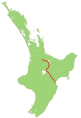
New Zealand State Highway 5
Encyclopedia
State Highway 5 is the second shortest of New Zealand
's eight national highways
. It extends from SH 1
at Tirau
, on the plains of the Waikato River
to SH 2 close to the Hawke Bay
coast at Bay View
, 10 km north of Napier
. Distances are measured from north to south.
For most of its length, SH5 is a two-lane single carriageway, other than a two-kilometre section of dual carriageway in Rotorua, with at-grade intersections and property accesses, both in rural and urban areas.
, heading east and ascending to cross the Mamaku Ranges
to Lake Rotorua
. The highway skirts the southwestern edge of the lake, entering the city of Rotorua
and continuing south through the Rotorua-Taupo thermal area to the upper reaches of the Waikato River
. It follows the river's upper valley past Wairakei
and the Huka Falls
to the town of Taupo
, on the northeastern edge of the lake
of the same name. Between Wairakei and Taupo, the highway runs concurrently with SH 1
.
and the watershed of the Mohaka River
, before crossing the 708-metre Titiokura Saddle and heading down to the coast close to the mouth of the Esk River
. This part of the road is very varied, with many points of interest on the route.
Soon after leaving Taupo, the highway passes "The Terraces", an 1889 hotel named for the now-lost local black silica terraces. Various hot pools are found in the area.
The 65,000 year-old volcanic Mount Tauhara
is seen to the east shortly after the road starts to climb to the volcanic plateau. Ther highway passes through the small settlement of Opepe, which is at the intersection of two major pre-European walking tracks (Taupo-Napier
and Urewera-Tokaanu
). A military stockade was built there in 1869 and the township thrived for several years in the late 19th century, though little remains of it today.
Beyond Opepe lie the Kaingaroa plains, formed from the ash from the great Taupo eruption of 186 AD. Up until 1955 the plains only supported tussock and scrub. With the use of clover and the overcoming of a cobalt deficiency in the soil, the development of large farms became possible. The Kaingaroa Forest
, which lies on these plains is one of the largest man made forests in the Southern Hemisphere. Radiata (Monterey) pine is the main species.
The Rangitaiki conservation area, a 5000 Hectare reserve of the tussock shrublands that once covered the plains, is located some 40 km southeast of Taupo. The area is also known for its “Frost flats”. Unlike in much of New Zealand, here tussock and shrub grow in lower areas sheltered by tall trees on the hills.
Several sets of waterfalls lie on the Waipunga River
close to the northern side of the road between Rangitaiki and Tarawera
, notably the Waipunga Falls and Hukawai Falls. The Waipunga Valley stretch of the highway was difficult to construct and passes through several deep rock cuttings. The highway continues past the hot springs of Tarawera
before climbing to the small settlement of Te Haroto, once a busy timber-milling town.
The highway next crosses the Mohaka River
, the site of one of New Zealand’s major road tragedies during the 1990s, when a housebus plunged from the bridge. The Mohaka river is a popular spot for both whitewater rafting and trout fishing.
The highway next ascends to cross the Titiokura Saddle, the site of a proposed electricity generating wind farm
, before passing through Te Pohue
, a former coaching stop for travellers heading inland from Napier. A few kilometres further on is an unsealed road leading to Trellinoe Park, one of New Zealand’s largest private gardens.
From here, the road descends into the Esk River
valley, a fertile area with vineyarrds and orchards, as well as one of the country’s few lavender
farms, which is open to the public..
the road met State Highway 2 at Petane (now Bay View
). The earthquake raised the land and altered the course of the Esk River; the course of the highway was changed to follow suit.
State Highway 5 once ran through central Rotorua. The old route left the current route at the Lake Road traffic lights, and followed the route of Lake Road, Ranolf Street, Amohau Street, Fenton Street, and Hemo Road, where it re-merges with the current section. Today, State Highway 5 follows Old Taupo Road, which bypasses the central city to the west.
New Zealand
New Zealand is an island country in the south-western Pacific Ocean comprising two main landmasses and numerous smaller islands. The country is situated some east of Australia across the Tasman Sea, and roughly south of the Pacific island nations of New Caledonia, Fiji, and Tonga...
's eight national highways
New Zealand State Highway network
The New Zealand State Highway network is the major national highway network in New Zealand. Just under 100 roads in both the North and South Islands are State Highways...
. It extends from SH 1
State Highway 1 (New Zealand)
State Highway 1 is the longest and most significant road in the New Zealand roading network, running the length of both main islands. It appears on road maps as SH 1 and on road signs as a white number 1 on a red shield, but it has the official designations SH 1N in the North Island, SH 1S in the...
at Tirau
Tirau
Tirau is a small town in the Waikato region of the North Island of New Zealand, 50 kilometres southeast of Hamilton. The town has a population of 732 . Tirau is primarily a farming town but in recent years has begun to exploit the income that comes from being on a major road...
, on the plains of the Waikato River
Waikato River
The Waikato River is the longest river in New Zealand. In the North Island, it runs for 425 kilometres from the eastern slopes of Mount Ruapehu, joining the Tongariro River system and emptying into Lake Taupo, New Zealand's largest lake. It drains Taupo at the lake's northeastern edge, creates the...
to SH 2 close to the Hawke Bay
Hawke Bay
Hawke Bay is a large bay on the eastern coast of the North Island of New Zealand. It stretches from the Mahia Peninsula in the northeast to Cape Kidnappers in the southwest, a distance of some 100 kilometres....
coast at Bay View
Bay View, New Zealand
Bay View is a settlement in the Hawke's Bay Region of the eastern North Island of New Zealand. It lies on State Highway 2 nine kilometres north of the centre of Napier. The area was previously known as Petane and was seized by Maori in the early 1860's with the idea of attacking Napier.-References:...
, 10 km north of Napier
Napier, New Zealand
Napier is a New Zealand city with a seaport, located in Hawke's Bay on the eastern coast of the North Island. The population of Napier is about About 18 kilometres south of Napier is the inland city of Hastings. These two neighboring cities are often called "The Twin Cities" or "The Bay Cities"...
. Distances are measured from north to south.
For most of its length, SH5 is a two-lane single carriageway, other than a two-kilometre section of dual carriageway in Rotorua, with at-grade intersections and property accesses, both in rural and urban areas.
Tirau to Taupo
The highway leaves SH1 at TirauTirau
Tirau is a small town in the Waikato region of the North Island of New Zealand, 50 kilometres southeast of Hamilton. The town has a population of 732 . Tirau is primarily a farming town but in recent years has begun to exploit the income that comes from being on a major road...
, heading east and ascending to cross the Mamaku Ranges
Mamaku Ranges
The Mamaku Ranges are a range of rugged hills in the North Island of New Zealand. Located to the west of Lake Rotorua and north of Lake Taupo, they lie to the immediate south of the Kaimai Range and can be thought of as an extension of it, in much the same way that the Kaimai Range can be...
to Lake Rotorua
Lake Rotorua
Lake Rotorua is the second largest lake in the North Island of New Zealand by surface area, and covers 79.8km2. With a mean depth of only 10 metres it is considerably smaller than nearby Lake Tarawera in terms of volume of water. It is located in the Bay of Plenty region...
. The highway skirts the southwestern edge of the lake, entering the city of Rotorua
Rotorua
Rotorua is a city on the southern shores of the lake of the same name, in the Bay of Plenty region of the North Island of New Zealand. The city is the seat of the Rotorua District, a territorial authority encompassing the city and several other nearby towns...
and continuing south through the Rotorua-Taupo thermal area to the upper reaches of the Waikato River
Waikato River
The Waikato River is the longest river in New Zealand. In the North Island, it runs for 425 kilometres from the eastern slopes of Mount Ruapehu, joining the Tongariro River system and emptying into Lake Taupo, New Zealand's largest lake. It drains Taupo at the lake's northeastern edge, creates the...
. It follows the river's upper valley past Wairakei
Wairakei
Wairakei is the name of a power station, small settlement and a geothermal area a few kilometres north of Taupo, in the centre of the North Island of New Zealand, on the Waikato River.- Geothermal field :...
and the Huka Falls
Huka Falls
The Huka Falls are a set of waterfalls on the Waikato River that drains Lake Taupo in New Zealand.A few hundred metres upstream from the Huka Falls, the Waikato River narrows from roughly 100 metres across into a narrow canyon only 15 metres across...
to the town of Taupo
Taupo
Taupo is a town on the shore of Lake Taupo in the centre of the North Island of New Zealand. It is the seat of the Taupo District Council and lies in the southern Waikato Region....
, on the northeastern edge of the lake
Lake Taupo
Lake Taupo is a lake situated in the North Island of New Zealand. With a surface area of , it is the largest lake by surface area in New Zealand, and the second largest freshwater lake by surface area in geopolitical Oceania after Lake Murray ....
of the same name. Between Wairakei and Taupo, the highway runs concurrently with SH 1
State Highway 1 (New Zealand)
State Highway 1 is the longest and most significant road in the New Zealand roading network, running the length of both main islands. It appears on road maps as SH 1 and on road signs as a white number 1 on a red shield, but it has the official designations SH 1N in the North Island, SH 1S in the...
.
Taupo to Napier
From Taupo, SH 1 continues along the lake's eastern shore, while SH 5 heads southeast through the rough hill country of the Kaingaroa State Forest. The highway climbs and twists, crossing the headwaters of the Rangitaiki RiverRangitaiki River
The Rangitaiki River is the longest river in the Bay of Plenty region in New Zealand's North Island. It is 155 kilometres in length, and rises inland from northern Hawke Bay to the east of the Kaingaroa Forest....
and the watershed of the Mohaka River
Mohaka River
The Mohaka River is a river in the northern Hawke's Bay region of the eastern North Island of New Zealand. It flows east-southeast for 70 kilometres from the Ahimanawa Range, before flowing into Hawke Bay close to the settlement of Mohaka, 20 kilometres southwest of Wairoa.New Zealand's highest...
, before crossing the 708-metre Titiokura Saddle and heading down to the coast close to the mouth of the Esk River
Esk River, Hawke's Bay
The more northerly of the two Esk Rivers in New Zealand lies in Hawke's Bay, in the eastern North Island. One of the region's major rivers, it flows south from the slopes of Mount Taraponui in the Maungaharuru Range before turning east to reach Hawke Bay 10 kilometres to the north of Napier...
. This part of the road is very varied, with many points of interest on the route.
Soon after leaving Taupo, the highway passes "The Terraces", an 1889 hotel named for the now-lost local black silica terraces. Various hot pools are found in the area.
The 65,000 year-old volcanic Mount Tauhara
Mount Tauhara
Mount Tauhara is a dormant stratovolcano, reaching 3,569 feet above sea level, situated within the Taupō caldera towards the centre of the Taupō Volcanic Zone, which stretches from White Island in the north, to Mount Ruapehu in the south, to Mount Taranaki in the west....
is seen to the east shortly after the road starts to climb to the volcanic plateau. Ther highway passes through the small settlement of Opepe, which is at the intersection of two major pre-European walking tracks (Taupo-Napier
Napier, New Zealand
Napier is a New Zealand city with a seaport, located in Hawke's Bay on the eastern coast of the North Island. The population of Napier is about About 18 kilometres south of Napier is the inland city of Hastings. These two neighboring cities are often called "The Twin Cities" or "The Bay Cities"...
and Urewera-Tokaanu
Tokaanu
Tokaanu is a small settlement close to Turangi at the southern end of Lake Taupo. The Tokaanu Thermal Pools and the easy access to Lake Taupo make it a popular lakeside holiday destination. A short walking track through the Tokaanu thermal area leads past steaming hot mineral pools and small mud...
). A military stockade was built there in 1869 and the township thrived for several years in the late 19th century, though little remains of it today.
Beyond Opepe lie the Kaingaroa plains, formed from the ash from the great Taupo eruption of 186 AD. Up until 1955 the plains only supported tussock and scrub. With the use of clover and the overcoming of a cobalt deficiency in the soil, the development of large farms became possible. The Kaingaroa Forest
Kaingaroa Forest
Kaingaroa Forest is the largest forest in the North Island of New Zealand, and the largest plantation in the southern hemisphere.The forest covers 2900 km² in the inland East Cape and Bay of Plenty regions, and stretches south past the east coast of Lake Taupo...
, which lies on these plains is one of the largest man made forests in the Southern Hemisphere. Radiata (Monterey) pine is the main species.
The Rangitaiki conservation area, a 5000 Hectare reserve of the tussock shrublands that once covered the plains, is located some 40 km southeast of Taupo. The area is also known for its “Frost flats”. Unlike in much of New Zealand, here tussock and shrub grow in lower areas sheltered by tall trees on the hills.
Several sets of waterfalls lie on the Waipunga River
Waipunga River
The Waipunga River is a tributary of the Mohaka River, located between Taupo and Napier in New Zealand's North Island. It runs roughly 50 km from its source near the eastern edge of the Volcanic Plateau to its junction with the Mohaka, of which some 15 km follow alongside the Napier-Taupo highway...
close to the northern side of the road between Rangitaiki and Tarawera
Tarawera
Tarawera may refer to:* Mount Tarawera* Lake Tarawera* Tarawera * Tarawera River* Tarawera Falls...
, notably the Waipunga Falls and Hukawai Falls. The Waipunga Valley stretch of the highway was difficult to construct and passes through several deep rock cuttings. The highway continues past the hot springs of Tarawera
Tarawera
Tarawera may refer to:* Mount Tarawera* Lake Tarawera* Tarawera * Tarawera River* Tarawera Falls...
before climbing to the small settlement of Te Haroto, once a busy timber-milling town.
The highway next crosses the Mohaka River
Mohaka River
The Mohaka River is a river in the northern Hawke's Bay region of the eastern North Island of New Zealand. It flows east-southeast for 70 kilometres from the Ahimanawa Range, before flowing into Hawke Bay close to the settlement of Mohaka, 20 kilometres southwest of Wairoa.New Zealand's highest...
, the site of one of New Zealand’s major road tragedies during the 1990s, when a housebus plunged from the bridge. The Mohaka river is a popular spot for both whitewater rafting and trout fishing.
The highway next ascends to cross the Titiokura Saddle, the site of a proposed electricity generating wind farm
Wind farm
A wind farm is a group of wind turbines in the same location used to produce electric power. A large wind farm may consist of several hundred individual wind turbines, and cover an extended area of hundreds of square miles, but the land between the turbines may be used for agricultural or other...
, before passing through Te Pohue
Te Pohue
Te Pohue is a small settlement in inland Hawke's Bay, in New Zealand's eastern North Island. It lies on State Highway 5 31 kilometres inland from Whirinaki....
, a former coaching stop for travellers heading inland from Napier. A few kilometres further on is an unsealed road leading to Trellinoe Park, one of New Zealand’s largest private gardens.
From here, the road descends into the Esk River
Esk River
Esk River may refer to:*Esk River, Hawke's Bay, river of New Zealand*Esk River, Canterbury, river of New Zealand*Esk River, New South Wales, river of Northern New South Wales, Australia. A tributary of the Clarence River....
valley, a fertile area with vineyarrds and orchards, as well as one of the country’s few lavender
Lavender
The lavenders are a genus of 39 species of flowering plants in the mint family, Lamiaceae. An Old World genus, distributed from Macaronesia across Africa, the Mediterranean, South-West Asia, Arabia, Western Iran and South-East India...
farms, which is open to the public..
Route changes
Prior to the 1931 Hawke's Bay earthquake1931 Hawke's Bay earthquake
The 1931 Hawke's Bay earthquake, also known as the Napier earthquake, occurred in New Zealand at 10:47 am on Tuesday 3 February 1931, killing 256 and devastating the Hawke's Bay region. It remains New Zealand's deadliest natural disaster...
the road met State Highway 2 at Petane (now Bay View
Bay View, New Zealand
Bay View is a settlement in the Hawke's Bay Region of the eastern North Island of New Zealand. It lies on State Highway 2 nine kilometres north of the centre of Napier. The area was previously known as Petane and was seized by Maori in the early 1860's with the idea of attacking Napier.-References:...
). The earthquake raised the land and altered the course of the Esk River; the course of the highway was changed to follow suit.
State Highway 5 once ran through central Rotorua. The old route left the current route at the Lake Road traffic lights, and followed the route of Lake Road, Ranolf Street, Amohau Street, Fenton Street, and Hemo Road, where it re-merges with the current section. Today, State Highway 5 follows Old Taupo Road, which bypasses the central city to the west.
Major Junctions
| Territorial authority | Location | km | Destinations | Notes |
|---|---|---|---|---|
| South Waikato District South Waikato District The South Waikato District is a municipality in the Waikato region of the North Island of New Zealand. It is located between the cities of Hamilton to the north, Rotorua to the east, Taupo to the south and Ruapehu District to the west.... |
Tirau Tirau Tirau is a small town in the Waikato region of the North Island of New Zealand, 50 kilometres southeast of Hamilton. The town has a population of 732 . Tirau is primarily a farming town but in recent years has begun to exploit the income that comes from being on a major road... |
0 |  SH 1/Thermal Explorer Highway north SH 1/Thermal Explorer Highway north Hamilton Hamilton, New Zealand Hamilton is the centre of New Zealand's fourth largest urban area, and Hamilton City is the country's fourth largest territorial authority. Hamilton is in the Waikato Region of the North Island, approximately south of Auckland... |
SH 5 begins 37.9849°N 175.767689°W |
| SH 1 south Taupo Taupo Taupo is a town on the shore of Lake Taupo in the centre of the North Island of New Zealand. It is the seat of the Taupo District Council and lies in the southern Waikato Region.... |
||||
| Tapapa |  SH 28 SH 28 Putaruru Putaruru Putaruru is a small town in the Waikato region of New Zealand's North Island. It is on the Oraka River 65 kilometres south-east of Hamilton.... |
SH 5/SH 28 concurrency begins | ||
| SH 28 Matamata Matamata Matamata is a rural Waikato town in New Zealand with a population of around 12,000 . It is located near the base of the Kaimai Ranges, and is a thriving farming area known for Thoroughbred horse breeding and training pursuits... , Tauranga Tauranga Tauranga is the most populous city in the Bay of Plenty region, in the North Island of New Zealand.It was settled by Europeans in the early 19th century and was constituted as a city in 1963... |
SH 5/SH 28 concurrency ends | |||
| Rotorua District | Ngongotaha Ngongotaha Ngongotaha is a town on the western shores of Lake Rotorua in New Zealand's North Island.It is located 10 kilometers northwest of Rotorua city, and is often regarded as an outer suburb of the larger centre. However, most locals would be adamant that Ngongotaha is an independent village in its own... |
 SH 36 SH 36 Ngongotaha, Tauranga |
||
| Rotorua Rotorua Rotorua is a city on the southern shores of the lake of the same name, in the Bay of Plenty region of the North Island of New Zealand. The city is the seat of the Rotorua District, a territorial authority encompassing the city and several other nearby towns... |
50 |  SH 30A SH 30ANew Zealand State Highway 30 State Highway 30 is a New Zealand State Highway, linking the Waikato and Bay of Plenty towns of Te Kuiti, Mangakino, Rotorua, and Whakatane.... (Pukuatua Street) City Centre, Whakatane Whakatane Whakatane is a town in the eastern Bay of Plenty Region, in the North Island of New Zealand, and is the seat of the Bay of Plenty Regional Council. Whakatane is 90 km east of Tauranga and 89 km north-east of Rotorua, at the mouth of the Whakatane River.The town has a population of , with... |
||
| Whakarewarewa | 55 |  SH 30 SH 30New Zealand State Highway 30 State Highway 30 is a New Zealand State Highway, linking the Waikato and Bay of Plenty towns of Te Kuiti, Mangakino, Rotorua, and Whakatane.... east (Hemo Road) City Centre, Whakatane |
SH 5/SH 30 concurrency begins | |
| Waipa Village | 56 | SH 30 New Zealand State Highway 30 State Highway 30 is a New Zealand State Highway, linking the Waikato and Bay of Plenty towns of Te Kuiti, Mangakino, Rotorua, and Whakatane.... west Tokoroa Tokoroa Tokoroa is the third-largest town in the Waikato region of the North Island of New Zealand and largest settlement in the South Waikato district. Located 30 km southwest of Rotorua, close to the foot of the Mamaku Ranges, it is mid-way between Taupo and Hamilton on State Highway One... , Te Kuiti Te Kuiti Te Kuiti is a small town in the south of the Waikato region of the North Island of New Zealand. It lies at the junction of State Highways 3 and 30 and on the North Island Main Trunk Railway, 80 km south of Hamilton.... |
SH 5/SH 30 concurrency ends | |
| Waiotapu | 77 |  SH 38 SH 38New Zealand State Highway 38 State Highway 38 is one of New Zealand's State Highways on the North Island. It starts near Wai-O-Tapu at the intersection with SH 5 and it ends at Wairoa, where it connects to SH 2. It is the shortest connection from the Central North Island to the East Coast , but it is not often used as such... Murupara Murupara Murupara is a town located in the North Island of New Zealand. The town is situated in an isolated part of the Bay of Plenty region between the Kaingaroa Forest and Te Urewera National Park, on the banks of the Rangitaiki River, 65 kilometres southeast of Rotorua, along SH38. Murupara is the... , Waikaremoana Lake Waikaremoana Lake Waikaremoana is located in Te Urewera National Park in the North Island of New Zealand, 60 kilometres northwest of Wairoa and 80 kilometres southwest of Gisborne. It covers an area of 54 km². From the Maori Waikaremoana translates as 'sea of rippling waters'The lake lies in the heart of Tuhoe... |
||
| Golden Springs | 99 | Mihi Bridge Waikato River Waikato River The Waikato River is the longest river in New Zealand. In the North Island, it runs for 425 kilometres from the eastern slopes of Mount Ruapehu, joining the Tongariro River system and emptying into Lake Taupo, New Zealand's largest lake. It drains Taupo at the lake's northeastern edge, creates the... |
||
| Taupo District Taupo District The Taupo District covers 6,350 km² of land, as well as a further 610 km² of lake area, both in Lake Taupo, New Zealand's largest lake, and also in the smaller Lake Rotoaira. The district stretches from the small town of Mangakino in the northwest to the Tongariro National Park in the... |
||||
| Wairakei Wairakei Wairakei is the name of a power station, small settlement and a geothermal area a few kilometres north of Taupo, in the centre of the North Island of New Zealand, on the Waikato River.- Geothermal field :... |
124 | SH 1 north Hamilton |
SH 5/SH 1 concurrency begins 38.623442°N 176.099896°W |
|
| Taupo Taupo Taupo is a town on the shore of Lake Taupo in the centre of the North Island of New Zealand. It is the seat of the Taupo District Council and lies in the southern Waikato Region.... |
132 | Control Gates Bridge Waikato River Waikato River The Waikato River is the longest river in New Zealand. In the North Island, it runs for 425 kilometres from the eastern slopes of Mount Ruapehu, joining the Tongariro River system and emptying into Lake Taupo, New Zealand's largest lake. It drains Taupo at the lake's northeastern edge, creates the... |
||
| 135 | SH 1 south (Lake Terrace) Palmerston North Palmerston North Palmerston North is the main city of the Manawatu-Wanganui region of the North Island of New Zealand. It is an inland city with a population of and is the country's seventh largest city and eighth largest urban area. Palmerston North is located in the eastern Manawatu Plains near the north bank... |
SH 5/SH 1 concurrency begins 38.70511°N 176.08781°W |
||
| Hastings District Hastings, New Zealand The city of Hastings is a major urban settlement in the Hawke's Bay region of the North Island of New Zealand, and it is the largest settlement by population in Hawke's Bay. Hastings city is the administrative centre of the Hastings District... |
District contains no major junctions | |||
| Napier City Napier, New Zealand Napier is a New Zealand city with a seaport, located in Hawke's Bay on the eastern coast of the North Island. The population of Napier is about About 18 kilometres south of Napier is the inland city of Hastings. These two neighboring cities are often called "The Twin Cities" or "The Bay Cities"... |
Bay View |  SH 2 SH 2New Zealand State Highway 2 State Highway 2 is one of New Zealand's eight national highways. With the exception of State Highway 1, which runs the length of both of the country's main islands, SH 2 is the longest highway in the North Island... /Pacific Coast Highway north Wairoa Wairoa Wairoa is a town in New Zealand's North Island. It is the northernmost town in the Hawke's Bay region, and is located on the northern shore of Hawke Bay at the mouth of the Wairoa River and to the west of Mahia Peninsula... , Gisborne Gisborne, New Zealand -Economy:The harbour was host to many ships in the past and had developed as a river port to provide a more secure location for shipping compared with the open roadstead of Poverty Bay which can be exposed to southerly swells. A meat works was sited beside the harbour and meat and wool was shipped... |
SH 5 and Thermal Explorer Highway ends | |
| SH 2 New Zealand State Highway 2 State Highway 2 is one of New Zealand's eight national highways. With the exception of State Highway 1, which runs the length of both of the country's main islands, SH 2 is the longest highway in the North Island... /Pacific Coast Highway south Napier, Hastings Hastings, New Zealand The city of Hastings is a major urban settlement in the Hawke's Bay region of the North Island of New Zealand, and it is the largest settlement by population in Hawke's Bay. Hastings city is the administrative centre of the Hastings District... |
||||
See also
- List of New Zealand State Highways
- List of roads and highways, for notable or famous roads worldwide