
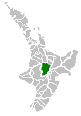
Taupo District
Encyclopedia
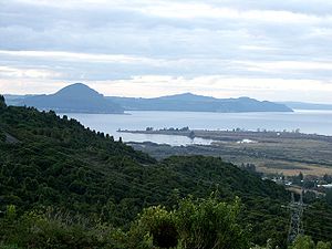
The Taupo District covers 6,350 km² of land, as well as a further 610 km² of lake area, both in Lake Taupo
, New Zealand
's largest lake, and also in the smaller Lake Rotoaira
. The district stretches from the small town of Mangakino
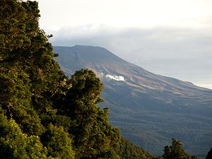
in the northwest to the Tongariro National Park
in the south, and east into the Kaingaroa Forest
. The district's population is largely located in the two main centres, Taupo
and Turangi
.
, with the vast majority of the district falling within the jurisdiction of Environment Waikato regional council
.
have been the main iwi
of the area for several hundred years. Major pa
were situated at the southern end of the lake to the west of the modern town of Turangi.
Taupo town was founded in 1869 as a garrison town during the New Zealand Wars, but remained small due to the poor volcanic soils of the region. It was not until the 1950s that the region started to develop, with forestry
and the construction of the Wairakei
geothermal power station.
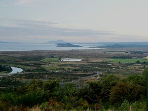
is situated on the north-eastern shore of the lake, and Turangi
is at the lake's southern extremity.
State Highway 1
winds along the eastern shore of Lake Taupo, and several small townships are located along it. Fewer people live on the northern or western shores, although there are several small settlements close to Taupo, and to the west of Turangi
(notably at Tokaanu
)
In the 2006 census
the resident population was:
Lake Taupo
Lake Taupo is a lake situated in the North Island of New Zealand. With a surface area of , it is the largest lake by surface area in New Zealand, and the second largest freshwater lake by surface area in geopolitical Oceania after Lake Murray ....
, New Zealand
New Zealand
New Zealand is an island country in the south-western Pacific Ocean comprising two main landmasses and numerous smaller islands. The country is situated some east of Australia across the Tasman Sea, and roughly south of the Pacific island nations of New Caledonia, Fiji, and Tonga...
's largest lake, and also in the smaller Lake Rotoaira
Lake Rotoaira
Lake Rotoaira is a small lake to the south of Lake Taupo on the North Island Volcanic Plateau in New Zealand. It covers an area of 13 km²....
. The district stretches from the small town of Mangakino
Mangakino
Mangakino is a small town on the banks of the Waikato River in the North Island of New Zealand. It is located close to the hydroelectric power station at Lake Maraetai, southeast of Hamilton. Its population in 2001 was 1257...
in the northwest to the Tongariro National Park
Tongariro National Park
Tongariro National Park is the oldest national park in New Zealand, located in the central North Island. It has been acknowledged by UNESCO as one of the 28 mixed cultural and natural World Heritage Sites....
in the south, and east into the Kaingaroa Forest
Kaingaroa Forest
Kaingaroa Forest is the largest forest in the North Island of New Zealand, and the largest plantation in the southern hemisphere.The forest covers 2900 km² in the inland East Cape and Bay of Plenty regions, and stretches south past the east coast of Lake Taupo...
. The district's population is largely located in the two main centres, Taupo
Taupo
Taupo is a town on the shore of Lake Taupo in the centre of the North Island of New Zealand. It is the seat of the Taupo District Council and lies in the southern Waikato Region....
and Turangi
Turangi
Turangi is a small town on the west bank of the Tongariro River, 50 kilometres south-west of Taupo on the North Island Volcanic Plateau of New Zealand. It was built to accommodate the workers associated with the Tongariro hydro-electric power development project and their families...
.
Local government
The district is governed by the Taupo District CouncilTaupo District Council
The Taupo District Council is a local council located in the Central North Island of New Zealand.-Area:The district stretches from the small town of Mangakino in the northwest to the Tongariro National Park in the south, and east into the Kaingaroa Forest, covering 6,970 km2...
, with the vast majority of the district falling within the jurisdiction of Environment Waikato regional council
Regions of New Zealand
The region is the top tier of local government in New Zealand. There are 16 regions of New Zealand. Eleven are governed by an elected regional council, while five are governed by territorial authorities which also perform the functions of a regional council and thus are known as unitary authorities...
.
History
Little is known about early Māori settlement near Taupo, although Ngati TuwharetoaNgati Tuwharetoa
Ngāti Tūwharetoa is an iwi descended from Ngātoro-i-rangi, the priest who navigated the Arawa canoe to New Zealand. The Tūwharetoa region extends from Te Awa o te Atua at Matata across the central plateau of the North Island to the lands around Mount Tongariro and Lake Taupo.The iwi is identified...
have been the main iwi
Iwi
In New Zealand society, iwi form the largest everyday social units in Māori culture. The word iwi means "'peoples' or 'nations'. In "the work of European writers which treat iwi and hapū as parts of a hierarchical structure", it has been used to mean "tribe" , or confederation of tribes,...
of the area for several hundred years. Major pa
Pa (Maori)
The word pā can refer to any Māori village or settlement, but in traditional use it referred to hillforts fortified with palisades and defensive terraces and also to fortified villages. They first came into being about 1450. They are located mainly in the North Island north of lake Taupo...
were situated at the southern end of the lake to the west of the modern town of Turangi.
Taupo town was founded in 1869 as a garrison town during the New Zealand Wars, but remained small due to the poor volcanic soils of the region. It was not until the 1950s that the region started to develop, with forestry
Forestry
Forestry is the interdisciplinary profession embracing the science, art, and craft of creating, managing, using, and conserving forests and associated resources in a sustainable manner to meet desired goals, needs, and values for human benefit. Forestry is practiced in plantations and natural stands...
and the construction of the Wairakei
Wairakei
Wairakei is the name of a power station, small settlement and a geothermal area a few kilometres north of Taupo, in the centre of the North Island of New Zealand, on the Waikato River.- Geothermal field :...
geothermal power station.
Population
The town of TaupoTaupo
Taupo is a town on the shore of Lake Taupo in the centre of the North Island of New Zealand. It is the seat of the Taupo District Council and lies in the southern Waikato Region....
is situated on the north-eastern shore of the lake, and Turangi
Turangi
Turangi is a small town on the west bank of the Tongariro River, 50 kilometres south-west of Taupo on the North Island Volcanic Plateau of New Zealand. It was built to accommodate the workers associated with the Tongariro hydro-electric power development project and their families...
is at the lake's southern extremity.
State Highway 1
New Zealand State Highway network
The New Zealand State Highway network is the major national highway network in New Zealand. Just under 100 roads in both the North and South Islands are State Highways...
winds along the eastern shore of Lake Taupo, and several small townships are located along it. Fewer people live on the northern or western shores, although there are several small settlements close to Taupo, and to the west of Turangi
Turangi
Turangi is a small town on the west bank of the Tongariro River, 50 kilometres south-west of Taupo on the North Island Volcanic Plateau of New Zealand. It was built to accommodate the workers associated with the Tongariro hydro-electric power development project and their families...
(notably at Tokaanu
Tokaanu
Tokaanu is a small settlement close to Turangi at the southern end of Lake Taupo. The Tokaanu Thermal Pools and the easy access to Lake Taupo make it a popular lakeside holiday destination. A short walking track through the Tokaanu thermal area leads past steaming hot mineral pools and small mud...
)
In the 2006 census
New Zealand Census of Population and Dwellings
The New Zealand government department Statistics New Zealand conducts a census of population and dwellings every five years. The census scheduled for 2011 was cancelled due to circumstances surrounding the February 2011 Christchurch earthquake, however, and legislation introduced to hold the next...
the resident population was:
- Taupo: 22,300
- Turangi: 3,240
- Mangakino: 1,020
- Other (rural): 5,858
- Total population: 32,418