
Kaingaroa Forest
Encyclopedia

North Island
The North Island is one of the two main islands of New Zealand, separated from the much less populous South Island by Cook Strait. The island is in area, making it the world's 14th-largest island...
of New Zealand
New Zealand
New Zealand is an island country in the south-western Pacific Ocean comprising two main landmasses and numerous smaller islands. The country is situated some east of Australia across the Tasman Sea, and roughly south of the Pacific island nations of New Caledonia, Fiji, and Tonga...
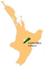
, and the largest plantation in the southern hemisphere.
The forest covers 2900 km² in the inland East Cape
East Cape
East Cape is the easternmost point of the main islands of New Zealand. It is located to the north of Gisborne in the northeast of the North Island....
and Bay of Plenty
Bay of Plenty
The Bay of Plenty , often abbreviated to BOP, is a region in the North Island of New Zealand situated around the body of water of the same name...
regions, and stretches south past the east coast of Lake Taupo
Lake Taupo
Lake Taupo is a lake situated in the North Island of New Zealand. With a surface area of , it is the largest lake by surface area in New Zealand, and the second largest freshwater lake by surface area in geopolitical Oceania after Lake Murray ....
. The headquarters of the forest are at the small settlement of Kaingaroa, 50 kilometres southeast of Rotorua
Rotorua
Rotorua is a city on the southern shores of the lake of the same name, in the Bay of Plenty region of the North Island of New Zealand. The city is the seat of the Rotorua District, a territorial authority encompassing the city and several other nearby towns...
.
The forest was first planted in the late 1920sand owned as a state asset by the New Zealand government. While under government control it was known as the Kaingaroa State Forest.
In the 1980s the government sought to sell the forests to private interests. Several Māori iwi
Iwi
In New Zealand society, iwi form the largest everyday social units in Māori culture. The word iwi means "'peoples' or 'nations'. In "the work of European writers which treat iwi and hapū as parts of a hierarchical structure", it has been used to mean "tribe" , or confederation of tribes,...
went to Court to prevent the sale, arguing that they were the traditional owners of the land, that the land had been wrongfully taken from them, and that the government should retain the land until a settlement of the claims had been reached. It has taken 20 years to reach settlement of those claims and to see the forest lands returned to their traditional owners. On 1 July 2009, it passed to a group of tribes that were the traditional land owners in partial settlement of their claims that the Crown breached the Treaty of Waitangi. The forests themselves (the trees) continue to be owned by a private company (Kaingaroa Timberlands Ltd), which holds a forestry licence over the land.
New Zealand State Highway 38
New Zealand State Highway 38
State Highway 38 is one of New Zealand's State Highways on the North Island. It starts near Wai-O-Tapu at the intersection with SH 5 and it ends at Wairoa, where it connects to SH 2. It is the shortest connection from the Central North Island to the East Coast , but it is not often used as such...
, from Wai-O-Tapu to Murupara
Murupara
Murupara is a town located in the North Island of New Zealand. The town is situated in an isolated part of the Bay of Plenty region between the Kaingaroa Forest and Te Urewera National Park, on the banks of the Rangitaiki River, 65 kilometres southeast of Rotorua, along SH38. Murupara is the...
and further through the Ureweras
Te Urewera
Te Urewera is an area of the central North Island of New Zealand. Located in rough, sparsely populated hill country to the northeast of Lake Taupo, it is the historical home of Tuhoe, a Māori iwi known for their controversial stance on Māori sovereignty...
, to Wairoa
Wairoa
Wairoa is a town in New Zealand's North Island. It is the northernmost town in the Hawke's Bay region, and is located on the northern shore of Hawke Bay at the mouth of the Wairoa River and to the west of Mahia Peninsula...
, crosses the forest.