
New York State Route 86
Encyclopedia
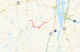
New York State Route 86 (NY 86) is a 39.11 miles (62.94 km) long state highway
located within Adirondack Park in northern New York
, United States
, linking Franklin County
to Essex County
. The western terminus of the route is at NY 30
in the hamlet of Paul Smiths
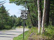
. The eastern terminus is at NY 9N
in Jay
. Although largely a two-lane road, NY 86 is one of only two east–west highways in the High Peaks
area of the Adirondack Park (the other being NY 73
), providing a major link between hamlets and tourist destinations.
NY 86 was established in the 1930 renumbering of state highways in New York, largely replacing a realigned NY 3
. North of Saranac Lake
, NY 86 initially followed modern NY 186
before being rerouted onto its modern alignment. The portion of NY 86 north of Harrietstown
was once NY 192
.
in Paul Smiths
, Franklin County
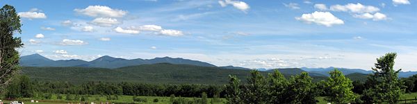
. The route heads east through the town of Brighton
, providing mountain views of Adirondack Park. After passing through the tiny communities of Easy Street and Gabriels
and traversing the southern edge of Paul Smiths College, NY 86 turns south to serve Harrietstown
, where it meets NY 186
at the hamlet of the same name. NY 86 continues southward to Saranac Lake
, the largest community on NY 86 in Franklin County. Moving through Saranac Lake, the business and tourism anchor for the area, NY 86 is well marked, but follows local roads to an intersection with NY 3
in the village center. The routes briefly overlap before splitting at the northern edge of Lake Flower
.
 East of NY 3, NY 86 becomes the primary lakeside roadway as it follows the northern and eastern extents of Lake Flower into Essex County
. Roughly 0.75 miles (1.21 km) into the county, NY 86 leaves the lakeshore and turns northeastward toward the small hamlet of Ray Brook
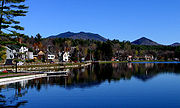
. Farther east, the highway travels through the Clifford R. Pettis Memorial Forest before arriving in the village of Lake Placid
as Saranac Avenue.
NY 86 proceeds eastward through the village, coming within view of Lake Placid
before turning south onto Main Street at the western shore of Mirror Lake
. As Main, NY 86 runs through the village and along Mirror Lake as the major tourist thoroughfare, passing numerous businesses and the sites of the 1936
and 1980 Winter Olympics
. At the southern edge of the village, Route 86 intersects the western terminus of NY 73
.
 Outside of Lake Placid, NY 86 enters the town of Wilmington
, home of the Olympic Ski Center at Whiteface Mountain
. Through Wilmington, the road largely follows the Ausable River northeastward, providing scenic views as it heads through "Wilmington Notch," noted for trout fishing. At an intersection with the eastern terminus of NY 431
in the hamlet of Wilmington, NY 86 turns eastward and crosses into the town of Jay
, where it terminates at NY 9N
at the town's village green.
Route 86 runs adjacent to the west branch of the Ausable River through a stretch that Trout Unlimited's Guide to America's 100 Best Trout Streams describes as one of the finest river fishing spots in the United States.
to Jay
via Saranac Lake
and Lake Placid
was originally part of the Theodore Roosevelt International Highway
, an auto trail
extending across the North America
n continent from the Pacific Ocean
to the Atlantic Ocean
. When the first set of posted routes in New York
were assigned in 1924, NY 3
was assigned to the entirety of the highway within New York.
NY 3 remained in place up to the 1930 renumbering of state highways in New York when it was rerouted onto its modern alignment through the North Country
. The portion of former NY 3 from Harrietstown
to Jay, as well as a section of former NY 10
(modern NY 186
) from Harrietstown to Lake Clear, was redesignated as NY 86. North of Harrietstown, the former alignment of NY 3 became NY 408 from Harrietstown to Gabriels
and the western half of NY 192
from Gabriels to Paul Smiths. Ca. 1932, NY 408 was co-designated as part of NY 365
, a designation that supplanted NY 408 ca. 1938. NY 365 was rerouted in the mid-1940s, leaving the Harrietstown–Gabriels roadway unnumbered.
In the early 1950s, NY 365's old routing between Harrietstown and Gabriels was designated as NY 192A, a spur route of NY 192. NY 192A was removed from the state highway system on January 7, 1980, when NY 192 was rerouted east of Gabriels to follow NY 192A. On March 28, 1989, NY 192 was eliminated in much the same way as its spur route as NY 86 was rerouted to follow NY 192 through Gabriels to Paul Smiths. NY 86's former routing past the Adirondack Regional Airport
became NY 186
.
 NY 86A was a spur route connecting NY 86 in Lake Placid to NY 9N
in Keene
. It was assigned as part of the 1930 renumbering of state highways in New York and replaced by an extended NY 73
in the mid-1950s.
State highway
State highway, state road or state route can refer to one of three related concepts, two of them related to a state or provincial government in a country that is divided into states or provinces :#A...
located within Adirondack Park in northern New York
New York
New York is a state in the Northeastern region of the United States. It is the nation's third most populous state. New York is bordered by New Jersey and Pennsylvania to the south, and by Connecticut, Massachusetts and Vermont to the east...
, United States
United States
The United States of America is a federal constitutional republic comprising fifty states and a federal district...
, linking Franklin County
Franklin County, New York
Franklin County is a county located in the U.S. state of New York. As of the 2010 census, the population was 51,599. It is named in honor of American Founding Father Benjamin Franklin...
to Essex County
Essex County, New York
Essex County is a county located in the U.S. state of New York. As of the 2010 census, the population was 39,370. Its name is from the English county of Essex. Its county seat is Elizabethtown...
. The western terminus of the route is at NY 30
New York State Route 30
New York State Route 30 is a state highway in the central part of New York in the United States. It extends for from an interchange with NY 17 in the Southern Tier to the Canadian border in the state's North Country, where it continues into Quebec as Route 138. On a regional level,...
in the hamlet of Paul Smiths
Paul Smiths, New York
Paul Smiths is a hamlet in the Town of Brighton in Franklin County, New York, on Lower Saint Regis Lake, in the Adirondacks, 10 miles north of Saranac Lake, located at 44°26' North 74°15' West....
. The eastern terminus is at NY 9N
New York State Route 9N
New York State Route 9N is a north–south state highway in northeastern New York, United States. It extends from an intersection with U.S. Route 9 , NY 29, and NY 50 in the city of Saratoga Springs to a junction with US 9 and NY 22 in the Clinton County village of...
in Jay
Jay, New York
Jay is a town in Essex County, New York, United States. The population was 2,306 at the 2000 census. The town is named after John Jay, governor of New York when the town was formed....
. Although largely a two-lane road, NY 86 is one of only two east–west highways in the High Peaks
High Peaks Wilderness Area
The High Peaks Wilderness Area, the largest Forest Preserve unit in New York, is located in three counties and six towns in the Adirondack Park: Harrietstown in Franklin County, North Elba, Keene, North Hudson and Newcomb in Essex County and Long Lake in Hamilton County.-Geography:It is roughly...
area of the Adirondack Park (the other being NY 73
New York State Route 73
New York State Route 73 is a state highway located entirely within Essex County, New York, United States. The highway begins at an intersection with NY 86 in the village of Lake Placid and ends at a junction with U.S. Route 9 north of the hamlet of Underwood in the extreme...
), providing a major link between hamlets and tourist destinations.
NY 86 was established in the 1930 renumbering of state highways in New York, largely replacing a realigned NY 3
New York State Route 3
New York State Route 3 is a major east–west state highway in New York, United States, that connects central New York to the North Country region near the Canadian border via Adirondack Park. The route extends for between its western terminus at an intersection with NY 104A in the Cayuga...
. North of Saranac Lake
Saranac Lake, New York
Saranac Lake is a village located in the state of New York, United States. As of the 2010 census, the population was 5,406. The village is named after Upper, Middle, and Lower Saranac Lakes, which are nearby....
, NY 86 initially followed modern NY 186
New York State Route 186
New York State Route 186 is a short east–west state highway in northern New York, United States. The highway is located entirely within the town of Harrietstown in the southwest part of Franklin County. The western terminus is at NY 30 and the eastern terminus is at NY 86. ...
before being rerouted onto its modern alignment. The portion of NY 86 north of Harrietstown
Harrietstown, New York
Harrietstown is a town in Franklin County, New York, United States. The population was 5,575 at the 2000 census, much of it concentrated in the village of Saranac Lake....
was once NY 192
New York State Route 192
New York State Route 192 was a long east–west state highway in Franklin County, New York, United States. The western terminus of the route was at an intersection with NY 30 in the hamlet of Paul Smiths within the town of Brighton. Its eastern terminus was at a junction with NY 86...
.
Route description
NY 86 begins at NY 30New York State Route 30
New York State Route 30 is a state highway in the central part of New York in the United States. It extends for from an interchange with NY 17 in the Southern Tier to the Canadian border in the state's North Country, where it continues into Quebec as Route 138. On a regional level,...
in Paul Smiths
Paul Smiths, New York
Paul Smiths is a hamlet in the Town of Brighton in Franklin County, New York, on Lower Saint Regis Lake, in the Adirondacks, 10 miles north of Saranac Lake, located at 44°26' North 74°15' West....
, Franklin County
Franklin County, New York
Franklin County is a county located in the U.S. state of New York. As of the 2010 census, the population was 51,599. It is named in honor of American Founding Father Benjamin Franklin...
. The route heads east through the town of Brighton
Brighton, Franklin County, New York
Brighton is a town in Franklin County, New York, United States. The population was 1,682 at the 2000 census. It was named after Brighton, England by early surveyors in the region....
, providing mountain views of Adirondack Park. After passing through the tiny communities of Easy Street and Gabriels
Gabriels, New York
Gabriels is a hamlet in the Town of Brighton in Franklin County, New York inside the Adirondack Park near Paul Smiths, New York. The village grew up around a cure facility for tuberculosis,The Gabriels Sanatorium, opened in 1897 by the Catholic Sisters of Mercy. The land was donated by Paul Smith...
and traversing the southern edge of Paul Smiths College, NY 86 turns south to serve Harrietstown
Harrietstown, New York
Harrietstown is a town in Franklin County, New York, United States. The population was 5,575 at the 2000 census, much of it concentrated in the village of Saranac Lake....
, where it meets NY 186
New York State Route 186
New York State Route 186 is a short east–west state highway in northern New York, United States. The highway is located entirely within the town of Harrietstown in the southwest part of Franklin County. The western terminus is at NY 30 and the eastern terminus is at NY 86. ...
at the hamlet of the same name. NY 86 continues southward to Saranac Lake
Saranac Lake, New York
Saranac Lake is a village located in the state of New York, United States. As of the 2010 census, the population was 5,406. The village is named after Upper, Middle, and Lower Saranac Lakes, which are nearby....
, the largest community on NY 86 in Franklin County. Moving through Saranac Lake, the business and tourism anchor for the area, NY 86 is well marked, but follows local roads to an intersection with NY 3
New York State Route 3
New York State Route 3 is a major east–west state highway in New York, United States, that connects central New York to the North Country region near the Canadian border via Adirondack Park. The route extends for between its western terminus at an intersection with NY 104A in the Cayuga...
in the village center. The routes briefly overlap before splitting at the northern edge of Lake Flower
Lake Flower
Lake Flower is a lake in Franklin County and Essex County in the Adirondacks; it was created by damming the Saranac River in 1827. It was originally called Newell's Pond, but was later named for New York governor Roswell P. Flower. It is the only lake within the village of Saranac Lake. The...
.
Essex County, New York
Essex County is a county located in the U.S. state of New York. As of the 2010 census, the population was 39,370. Its name is from the English county of Essex. Its county seat is Elizabethtown...
. Roughly 0.75 miles (1.21 km) into the county, NY 86 leaves the lakeshore and turns northeastward toward the small hamlet of Ray Brook
Ray Brook, New York
Ray Brook is a hamlet in New York State, USA located on NY 86 between Saranac Lake and Lake Placid in the Town of North Elba in Essex County. It is the site of the Adirondack Park Agency, the District 5 office of the New York State Department of Environmental Conservation, the Federal...
. Farther east, the highway travels through the Clifford R. Pettis Memorial Forest before arriving in the village of Lake Placid
Lake Placid, New York
Lake Placid is a village in the Adirondack Mountains in Essex County, New York, United States. As of the 2000 census, the village had a population of 2,638....
as Saranac Avenue.
NY 86 proceeds eastward through the village, coming within view of Lake Placid
Lake Placid (New York)
The body of water called Lake Placid is in the Adirondack Mountains in northern New York in the USA. The lake is approximately , and has an average depth of about . It is located in the towns of North Elba and St...
before turning south onto Main Street at the western shore of Mirror Lake
Mirror Lake (New York)
The oligotrophic, circumneutral body of water called Mirror Lake is in the Adirondack Mountains in northern New York in the USA. The lake is approximately , and has an average depth of about . It is located in the village of Lake Placid, near the center of the town of North Elba in Essex County....
. As Main, NY 86 runs through the village and along Mirror Lake as the major tourist thoroughfare, passing numerous businesses and the sites of the 1936
1936 Winter Olympics
The 1936 Winter Olympics, officially known as the IV Olympic Winter Games, were a winter multi-sport event which was celebrated in 1936 in the market town of Garmisch-Partenkirchen in Bavaria, Germany. Germany also hosted the Summer Olympics the same year in Berlin...
and 1980 Winter Olympics
1980 Winter Olympics
The 1980 Winter Olympics, officially known as the XIII Olympic Winter Games, was a multi-sport event which was celebrated from 13 February through 24 February 1980 in Lake Placid, New York, United States of America. This was the second time the Upstate New York village hosted the Games, after 1932...
. At the southern edge of the village, Route 86 intersects the western terminus of NY 73
New York State Route 73
New York State Route 73 is a state highway located entirely within Essex County, New York, United States. The highway begins at an intersection with NY 86 in the village of Lake Placid and ends at a junction with U.S. Route 9 north of the hamlet of Underwood in the extreme...
.
Wilmington, New York
Wilmington is a town in Essex County, New York, United States. The population was 1,131 at the 2000 census. The town is named after Wilmington, Delaware.The Town of Wilmington is on the county's north border and is southwest of Plattsburgh...
, home of the Olympic Ski Center at Whiteface Mountain
Whiteface Mountain
Whiteface Mountain is the fifth-highest mountain in New York State, and one of the High Peaks of the Adirondack Mountains. Set apart from most of the other High Peaks, the summit offers a 360-degree view featuring the Adirondacks and perhaps on a clear day glimpses of Vermont and even Canada. The...
. Through Wilmington, the road largely follows the Ausable River northeastward, providing scenic views as it heads through "Wilmington Notch," noted for trout fishing. At an intersection with the eastern terminus of NY 431
New York State Route 431
New York State Route 431 is a state highway in Essex County, New York, United States. The highway, also known as the Whiteface Mountain Veterans Memorial Highway, begins at an intersection with NY 86 in Wilmington and climbs Whiteface Mountain in the Adirondacks...
in the hamlet of Wilmington, NY 86 turns eastward and crosses into the town of Jay
Jay, New York
Jay is a town in Essex County, New York, United States. The population was 2,306 at the 2000 census. The town is named after John Jay, governor of New York when the town was formed....
, where it terminates at NY 9N
New York State Route 9N
New York State Route 9N is a north–south state highway in northeastern New York, United States. It extends from an intersection with U.S. Route 9 , NY 29, and NY 50 in the city of Saratoga Springs to a junction with US 9 and NY 22 in the Clinton County village of...
at the town's village green.
Route 86 runs adjacent to the west branch of the Ausable River through a stretch that Trout Unlimited's Guide to America's 100 Best Trout Streams describes as one of the finest river fishing spots in the United States.
History
What is now NY 86 from Paul SmithsPaul Smiths, New York
Paul Smiths is a hamlet in the Town of Brighton in Franklin County, New York, on Lower Saint Regis Lake, in the Adirondacks, 10 miles north of Saranac Lake, located at 44°26' North 74°15' West....
to Jay
Jay, New York
Jay is a town in Essex County, New York, United States. The population was 2,306 at the 2000 census. The town is named after John Jay, governor of New York when the town was formed....
via Saranac Lake
Saranac Lake, New York
Saranac Lake is a village located in the state of New York, United States. As of the 2010 census, the population was 5,406. The village is named after Upper, Middle, and Lower Saranac Lakes, which are nearby....
and Lake Placid
Lake Placid, New York
Lake Placid is a village in the Adirondack Mountains in Essex County, New York, United States. As of the 2000 census, the village had a population of 2,638....
was originally part of the Theodore Roosevelt International Highway
Theodore Roosevelt International Highway
The Theodore Roosevelt International Highway was a transcontinental North American highway through the United States and Canada that ran from Portland, Maine, to Portland, Oregon. Its length was about .-Route description:...
, an auto trail
Auto trail
The system of auto trails was an informal network of marked routes that existed in the United States and Canada in the early part of the 20th century. Marked with colored bands on telephone poles, the trails were intended to help travellers in the early days of the automobile.Auto trails were...
extending across the North America
North America
North America is a continent wholly within the Northern Hemisphere and almost wholly within the Western Hemisphere. It is also considered a northern subcontinent of the Americas...
n continent from the Pacific Ocean
Pacific Ocean
The Pacific Ocean is the largest of the Earth's oceanic divisions. It extends from the Arctic in the north to the Southern Ocean in the south, bounded by Asia and Australia in the west, and the Americas in the east.At 165.2 million square kilometres in area, this largest division of the World...
to the Atlantic Ocean
Atlantic Ocean
The Atlantic Ocean is the second-largest of the world's oceanic divisions. With a total area of about , it covers approximately 20% of the Earth's surface and about 26% of its water surface area...
. When the first set of posted routes in New York
New York
New York is a state in the Northeastern region of the United States. It is the nation's third most populous state. New York is bordered by New Jersey and Pennsylvania to the south, and by Connecticut, Massachusetts and Vermont to the east...
were assigned in 1924, NY 3
New York State Route 3
New York State Route 3 is a major east–west state highway in New York, United States, that connects central New York to the North Country region near the Canadian border via Adirondack Park. The route extends for between its western terminus at an intersection with NY 104A in the Cayuga...
was assigned to the entirety of the highway within New York.
NY 3 remained in place up to the 1930 renumbering of state highways in New York when it was rerouted onto its modern alignment through the North Country
North Country, New York
The North Country is a region of the U.S. state of New York that encompasses the state's extreme northern frontier, bordering Lake Ontario on the west, the Saint Lawrence River and the Canadian provinces of Ontario and Quebec on the north and northwest, and Lake Champlain and Vermont on the east...
. The portion of former NY 3 from Harrietstown
Harrietstown, New York
Harrietstown is a town in Franklin County, New York, United States. The population was 5,575 at the 2000 census, much of it concentrated in the village of Saranac Lake....
to Jay, as well as a section of former NY 10
New York State Route 10
New York State Route 10 is a north–south state highway in the Central New York and North Country regions of New York in the United States. It extends for from the Quickway in Deposit, Delaware County to NY 8 at Higgins Bay, a hamlet in the Hamilton County town of Arietta...
(modern NY 186
New York State Route 186
New York State Route 186 is a short east–west state highway in northern New York, United States. The highway is located entirely within the town of Harrietstown in the southwest part of Franklin County. The western terminus is at NY 30 and the eastern terminus is at NY 86. ...
) from Harrietstown to Lake Clear, was redesignated as NY 86. North of Harrietstown, the former alignment of NY 3 became NY 408 from Harrietstown to Gabriels
Gabriels, New York
Gabriels is a hamlet in the Town of Brighton in Franklin County, New York inside the Adirondack Park near Paul Smiths, New York. The village grew up around a cure facility for tuberculosis,The Gabriels Sanatorium, opened in 1897 by the Catholic Sisters of Mercy. The land was donated by Paul Smith...
and the western half of NY 192
New York State Route 192
New York State Route 192 was a long east–west state highway in Franklin County, New York, United States. The western terminus of the route was at an intersection with NY 30 in the hamlet of Paul Smiths within the town of Brighton. Its eastern terminus was at a junction with NY 86...
from Gabriels to Paul Smiths. Ca. 1932, NY 408 was co-designated as part of NY 365
New York State Route 365
New York State Route 365 is an east–west state highway in the central portion of New York in the United States. It extends for from an intersection with NY 5 east of the Oneida County city of Oneida to a junction with NY 8 in the Herkimer County town of Ohio...
, a designation that supplanted NY 408 ca. 1938. NY 365 was rerouted in the mid-1940s, leaving the Harrietstown–Gabriels roadway unnumbered.
In the early 1950s, NY 365's old routing between Harrietstown and Gabriels was designated as NY 192A, a spur route of NY 192. NY 192A was removed from the state highway system on January 7, 1980, when NY 192 was rerouted east of Gabriels to follow NY 192A. On March 28, 1989, NY 192 was eliminated in much the same way as its spur route as NY 86 was rerouted to follow NY 192 through Gabriels to Paul Smiths. NY 86's former routing past the Adirondack Regional Airport
Adirondack Regional Airport
Adirondack Regional Airport is a public use airport located four nautical miles northwest of the central business district of Saranac Lake, in Franklin County, New York, United States. The airport is owned by the Town of Harrietstown...
became NY 186
New York State Route 186
New York State Route 186 is a short east–west state highway in northern New York, United States. The highway is located entirely within the town of Harrietstown in the southwest part of Franklin County. The western terminus is at NY 30 and the eastern terminus is at NY 86. ...
.
NY 86A
New York State Route 9N
New York State Route 9N is a north–south state highway in northeastern New York, United States. It extends from an intersection with U.S. Route 9 , NY 29, and NY 50 in the city of Saratoga Springs to a junction with US 9 and NY 22 in the Clinton County village of...
in Keene
Keene, New York
Keene is a town in central Essex County, New York, United States. The population was 1,063 at the 2000 census. Keene is the home of Mount Marcy, the highest mountain in New York state, as well as the Great Range and 15 of the 46 High Peaks, and the Ausable Lakes, the source of the Ausable River...
. It was assigned as part of the 1930 renumbering of state highways in New York and replaced by an extended NY 73
New York State Route 73
New York State Route 73 is a state highway located entirely within Essex County, New York, United States. The highway begins at an intersection with NY 86 in the village of Lake Placid and ends at a junction with U.S. Route 9 north of the hamlet of Underwood in the extreme...
in the mid-1950s.
Major intersections