
Harrietstown, New York
Encyclopedia
Harrietstown is a town
in Franklin County
, New York
, United States
. The population was 5,575 at the 2000 census, much of it concentrated in the village of Saranac Lake
.
The Town of Harrietstown is in the southeast corner of the county and is south of the Town of Brighton
.
in 1841. At the end of the 19th century it became the location for sanatoria for the treatment of lung diseases, taking advantage of the clear mountain air.
By 1900, the area became a tourist area, assisted by the winter carnivals begun in 1898.
, the town has a total area of 213.6 square miles (553.2 km²), of which, 196.8 square miles (509.7 km²) of it is land and 16.8 square miles (43.5 km²) of it (7.88%) is water.
Harrietstown is inside the Adirondack Park.
The south town line is the border of Hamilton County
and Essex County
. The east town line is also on the border of Essex County.
New York State Route 3
runs east-west through the town, while New York State Route 30
and New York State Route 86
traverse the town running north-south. NY-3 and NY-30 joined at the west town line. New York State Route 186
connects NY-3 to NY-86.
The Raquette River
is in the southwest part of Harrietstown.
of 2000, there were 5,575 people, 2,544 households, and 1,340 families residing in the town. The population density
was 28.3 people per square mile (10.9/km²). There were 3,417 housing units at an average density of 17.4 per square mile (6.7/km²). The racial makeup of the town was 97.22% White, 0.52% African American, 0.34% Native American, 0.65% Asian, 0.22% from other races
, and 1.06% from two or more races. Hispanic or Latino of any race were 1.06% of the population.
There were 2,544 households out of which 27.2% had children under the age of 18 living with them, 38.8% were married couples
living together, 9.4% had a female householder with no husband present, and 47.3% were non-families. 39.1% of all households were made up of individuals and 14.3% had someone living alone who was 65 years of age or older. The average household size was 2.16 and the average family size was 2.91.
In the town the population was spread out with 22.8% under the age of 18, 9.8% from 18 to 24, 28.1% from 25 to 44, 24.1% from 45 to 64, and 15.1% who were 65 years of age or older. The median age was 39 years. For every 100 females there were 94.2 males. For every 100 females age 18 and over, there were 91.8 males.
The median income for a household in the town was $31,838, and the median income for a family was $45,505. Males had a median income of $32,833 versus $25,407 for females. The per capita income
for the town was $18,529. About 7.4% of families and 12.6% of the population were below the poverty line, including 9.3% of those under age 18 and 20.1% of those age 65 or over.

Town
A town is a human settlement larger than a village but smaller than a city. The size a settlement must be in order to be called a "town" varies considerably in different parts of the world, so that, for example, many American "small towns" seem to British people to be no more than villages, while...
in Franklin County
Franklin County, New York
Franklin County is a county located in the U.S. state of New York. As of the 2010 census, the population was 51,599. It is named in honor of American Founding Father Benjamin Franklin...
, New York
New York
New York is a state in the Northeastern region of the United States. It is the nation's third most populous state. New York is bordered by New Jersey and Pennsylvania to the south, and by Connecticut, Massachusetts and Vermont to the east...
, United States
United States
The United States of America is a federal constitutional republic comprising fifty states and a federal district...
. The population was 5,575 at the 2000 census, much of it concentrated in the village of Saranac Lake
Saranac Lake, New York
Saranac Lake is a village located in the state of New York, United States. As of the 2010 census, the population was 5,406. The village is named after Upper, Middle, and Lower Saranac Lakes, which are nearby....
.
The Town of Harrietstown is in the southeast corner of the county and is south of the Town of Brighton
Brighton, Franklin County, New York
Brighton is a town in Franklin County, New York, United States. The population was 1,682 at the 2000 census. It was named after Brighton, England by early surveyors in the region....
.
History
The area around Saranac Lake was first settled around 1819. Harrietstown was formed from the Town of DuaneDuane, New York
Duane is a town in Franklin County, New York, United States. The population was 159 at the 2000 census. The town is named after James Duane, a developer and grandson of New York City Mayor James Duane....
in 1841. At the end of the 19th century it became the location for sanatoria for the treatment of lung diseases, taking advantage of the clear mountain air.
By 1900, the area became a tourist area, assisted by the winter carnivals begun in 1898.
Geography
According to the United States Census BureauUnited States Census Bureau
The United States Census Bureau is the government agency that is responsible for the United States Census. It also gathers other national demographic and economic data...
, the town has a total area of 213.6 square miles (553.2 km²), of which, 196.8 square miles (509.7 km²) of it is land and 16.8 square miles (43.5 km²) of it (7.88%) is water.
Harrietstown is inside the Adirondack Park.
The south town line is the border of Hamilton County
Hamilton County, New York
Hamilton County is a county located in the U.S. state of New York. It is named after Alexander Hamilton, the only member of the New York State delegation who signed the United States Constitution in 1787 and later the first United States Secretary of the Treasury. Its county seat is Lake Pleasant...
and Essex County
Essex County, New York
Essex County is a county located in the U.S. state of New York. As of the 2010 census, the population was 39,370. Its name is from the English county of Essex. Its county seat is Elizabethtown...
. The east town line is also on the border of Essex County.
New York State Route 3
New York State Route 3
New York State Route 3 is a major east–west state highway in New York, United States, that connects central New York to the North Country region near the Canadian border via Adirondack Park. The route extends for between its western terminus at an intersection with NY 104A in the Cayuga...
runs east-west through the town, while New York State Route 30
New York State Route 30
New York State Route 30 is a state highway in the central part of New York in the United States. It extends for from an interchange with NY 17 in the Southern Tier to the Canadian border in the state's North Country, where it continues into Quebec as Route 138. On a regional level,...
and New York State Route 86
New York State Route 86
New York State Route 86 is a long state highway located within Adirondack Park in northern New York, United States, linking Franklin County to Essex County. The western terminus of the route is at NY 30 in the hamlet of Paul Smiths. The eastern terminus is at NY 9N in Jay...
traverse the town running north-south. NY-3 and NY-30 joined at the west town line. New York State Route 186
New York State Route 186
New York State Route 186 is a short east–west state highway in northern New York, United States. The highway is located entirely within the town of Harrietstown in the southwest part of Franklin County. The western terminus is at NY 30 and the eastern terminus is at NY 86. ...
connects NY-3 to NY-86.
The Raquette River
Raquette River
The Raquette River, sometimes spelled Racquette, originates at Raquette Lake in the Adirondack Mountains in New York. long, it is the third longest river entirely in the state of New York....
is in the southwest part of Harrietstown.
Demographics
As of the censusCensus
A census is the procedure of systematically acquiring and recording information about the members of a given population. It is a regularly occurring and official count of a particular population. The term is used mostly in connection with national population and housing censuses; other common...
of 2000, there were 5,575 people, 2,544 households, and 1,340 families residing in the town. The population density
Population density
Population density is a measurement of population per unit area or unit volume. It is frequently applied to living organisms, and particularly to humans...
was 28.3 people per square mile (10.9/km²). There were 3,417 housing units at an average density of 17.4 per square mile (6.7/km²). The racial makeup of the town was 97.22% White, 0.52% African American, 0.34% Native American, 0.65% Asian, 0.22% from other races
Race (United States Census)
Race and ethnicity in the United States Census, as defined by the Federal Office of Management and Budget and the United States Census Bureau, are self-identification data items in which residents choose the race or races with which they most closely identify, and indicate whether or not they are...
, and 1.06% from two or more races. Hispanic or Latino of any race were 1.06% of the population.
There were 2,544 households out of which 27.2% had children under the age of 18 living with them, 38.8% were married couples
Marriage
Marriage is a social union or legal contract between people that creates kinship. It is an institution in which interpersonal relationships, usually intimate and sexual, are acknowledged in a variety of ways, depending on the culture or subculture in which it is found...
living together, 9.4% had a female householder with no husband present, and 47.3% were non-families. 39.1% of all households were made up of individuals and 14.3% had someone living alone who was 65 years of age or older. The average household size was 2.16 and the average family size was 2.91.
In the town the population was spread out with 22.8% under the age of 18, 9.8% from 18 to 24, 28.1% from 25 to 44, 24.1% from 45 to 64, and 15.1% who were 65 years of age or older. The median age was 39 years. For every 100 females there were 94.2 males. For every 100 females age 18 and over, there were 91.8 males.
The median income for a household in the town was $31,838, and the median income for a family was $45,505. Males had a median income of $32,833 versus $25,407 for females. The per capita income
Per capita income
Per capita income or income per person is a measure of mean income within an economic aggregate, such as a country or city. It is calculated by taking a measure of all sources of income in the aggregate and dividing it by the total population...
for the town was $18,529. About 7.4% of families and 12.6% of the population were below the poverty line, including 9.3% of those under age 18 and 20.1% of those age 65 or over.
Communities and locations in Harrietstown
- Adirondack Regional AirportAdirondack Regional AirportAdirondack Regional Airport is a public use airport located four nautical miles northwest of the central business district of Saranac Lake, in Franklin County, New York, United States. The airport is owned by the Town of Harrietstown...
(SLK) – An airportAirportAn airport is a location where aircraft such as fixed-wing aircraft, helicopters, and blimps take off and land. Aircraft may be stored or maintained at an airport...
in the northeast part of the town that services Saranac Lake the region. - Axton Landing – A hamletHamlet (place)A hamlet is usually a rural settlement which is too small to be considered a village, though sometimes the word is used for a different sort of community. Historically, when a hamlet became large enough to justify building a church, it was then classified as a village...
in the south part of the town by the Raquette RiverRaquette RiverThe Raquette River, sometimes spelled Racquette, originates at Raquette Lake in the Adirondack Mountains in New York. long, it is the third longest river entirely in the state of New York....
and south of NY-30. - Coreys – A location in the south part of the town, north of Axton Landing.
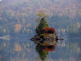
- Eagle Island – A prominent island in Lower Saranac LakeLower Saranac LakeLower Saranac Lake is one of three connected lakes, part of the Saranac River, near the village of Saranac Lake in the Adirondacks in northern New York. With Middle Saranac Lake and Upper Saranac Lake, a paddle with only one portage is possible. The Saranac Lake Islands Public Campground provides...
. - Fish Creek Ponds – A location on the west side of Upper Saranac LakeUpper Saranac LakeUpper Saranac Lake is one of three connected lakes, part of the Saranac River, in the towns of Santa Clara and Harrietstown, near the village of Saranac Lake in the Adirondacks in northern New York. Upper Saranac Lake is the sixth largest lake in the Adirondacks. With Middle Saranac Lake and...
. - Follensby Pond – A lake by the west town line.
- Harrietstown – A hamlet near the eastern town line on NY-86 and east of the airport.
- Lake Clear – A lake near the west town line.
- Lake ClearLake Clear, New YorkLake Clear is a hamlet and a lake in Franklin County, New York, United States. The area is named for Lake Clear, part of the original Seven Carries canoe route...
– A hamlet near the west town line on NY-30, south of the same-named lake. - Lake Clear Junction – A hamlet east of Lake Clear on NY-30.
- Lake ColbyLake ColbyLake Colby is a lake, located on NY-86 just outside the village of Saranac Lake, in Franklin County, New York in the Adirondacks; its outlet feeds into Lower Saranac Lake...
– A hamlet north of Saranac Lake village on NY-86. - McMasters Crossing – A hamlet south of Lake Clear on County Road 50.
- Lower Saranac LakeLower Saranac LakeLower Saranac Lake is one of three connected lakes, part of the Saranac River, near the village of Saranac Lake in the Adirondacks in northern New York. With Middle Saranac Lake and Upper Saranac Lake, a paddle with only one portage is possible. The Saranac Lake Islands Public Campground provides...
– A lakeLakeA lake is a body of relatively still fresh or salt water of considerable size, localized in a basin, that is surrounded by land. Lakes are inland and not part of the ocean and therefore are distinct from lagoons, and are larger and deeper than ponds. Lakes can be contrasted with rivers or streams,...
southwest of Saranac Lake village. - Middle Saranac LakeMiddle Saranac LakeMiddle Saranac Lake, also called Round Lake, is the smallest of three connected lakes, part of the Saranac River, near the village of Saranac Lake in the Adirondacks in northern New York. Two-thirds of its shoreline is state-owned...
– A lake in the south part of the town, mostly within the town. - Oseetah LakeOseetah LakeOseetah Lake is a lake in the New York Adirondack State Park two and a half miles south of the village of Saranac Lake on the Saranac River. It is located mostly in the town of Harrietstown, but its easternmost porttion extends into the town of North Elba....
– A lake on the east town line, south of Saranac Lake village. - Saranac LakeSaranac Lake, New YorkSaranac Lake is a village located in the state of New York, United States. As of the 2010 census, the population was 5,406. The village is named after Upper, Middle, and Lower Saranac Lakes, which are nearby....
– Part of the Village of Saranac Lake is at the eastern town line at the junction of NY-30 and NY-86. - Upper St. RegisUpper St. Regis, New YorkUpper St. Regis is a small hamlet on NY 30 near Upper St. Regis Lake 3 miles south of Paul Smiths in Franklin County, New York, USA....
– A location on NY-30 by the north town line. - Upper Saranac LakeUpper Saranac LakeUpper Saranac Lake is one of three connected lakes, part of the Saranac River, in the towns of Santa Clara and Harrietstown, near the village of Saranac Lake in the Adirondacks in northern New York. Upper Saranac Lake is the sixth largest lake in the Adirondacks. With Middle Saranac Lake and...
– The south end of the lake is in the western part of the town. - Wawbeek – A hamlet on NY-30 by the junction of County Road 45 at the west side of Upper Saranac Lake.