

New York State Route 59
Encyclopedia
New York State Route 59 (NY 59) is an east–west state highway
in southern Rockland County, New York
, in the United States. The route extends for 14.08 miles (22.66 km) from NY 17
in Hillburn
to U.S. Route 9W (US 9W) in Nyack
. In Suffern
, it has a concurrency
with US 202 for 0.05 mile (0.080467 km). NY 59 runs parallel to the New York State Thruway
its entire route. The routing of NY 59 became a state highway in 1911 and was signed as NY 59 in the late 1920s.
When NY 59 was first assigned, it began at NY 17 in Suffern. A western bypass of Suffern was designated as New York State Route 339 ca. 1932; however, it became part of a realigned NY 17 in the mid-1930s. NY 339 was reassigned to NY 17's former routing between Hillburn and Suffern, but it was replaced again ca. 1937 by an extended NY 59. In the 1960s, proposals surfaced for the Spring Valley Bypass, a highway that would utilize the NY 59 corridor between NY 306
in Monsey
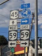
and NY 45
in Spring Valley
. The proposed highway was cancelled as a result of local opposition.
in Hillburn
, just south of the village of Sloatsburg
in southern Rockland County
. It heads to the southeast as the Korean War
Veterans Memorial Highway, crossing over the Ramapo River
and the Norfolk Southern Railway
before following both into Suffern
. The river leaves NY 59 just inside the village line; however, the railroad continues to run alongside NY 59 into the center of Suffern, where both pass under the New York State Thruway
near where Interstate 87 (I-87) connects to I-287
.
Just south of the I-87 overpass, NY 59 meets US 202 at Wayne Avenue. US 202 joins NY 59 for a one block wrong way concurrency along Orange Avenue—as NY 59 eastbound is paired with US 202 westbound and vice versa—during which time both routes cross the Norfolk Southern Railway at-grade. At the end of the overlap, US 202 continues south along Orange Avenue to the New Jersey
state line while NY 59 forks eastward toward central Rockland County. As NY 59 leaves Suffern and enters Airmont
, it passes Good Samaritan Hospital, a major hospital in Rockland County. While in Airmont, NY 59 intersects County Route 89 (CR 89) and CR 85. After leaving Airmont, NY 59 proceeds east through Monsey
, where it intersects the southern terminus of NY 306
.
As NY 59 passes Spring Valley High School
, it enters the village limits of Spring Valley
. While in Spring Valley, NY 59 has an overlap with CR 35A for about a tenth of a mile and meets the Thruway at exit 14. The route continues eastward into Nanuet
, where NY 59 passes through a heavy commercialized area. Before its busy intersection with CR 33
, NY 59 passes the Nanuet Mall
to its south and the Rockland Plaza to its north.
Upon entering West Nyack
, NY 59 intersects the Palisades Interstate Parkway
(exit 8) and NY 304
. The route proceeds onward, passing Palisades Center
, one of the largest shopping malls in the country. Immediately after passing the Palisades Center, NY 59 briefly enters Central Nyack. Here it connects to NY 303
by way of an interchange. Before hitting the Nyack
town line, NY 59 has its final interchange with the Thruway. The southbound entrance to the Tappan Zee Bridge
is via Mountainview Avenue, and the northbound entrance is via Polhemus Street.
At the Nyack line, NY 59 becomes known as Main Street. As Main Street, NY 59 runs under the Thruway one final time before the Thruway heads over the bridge. The route continues toward downtown Nyack; however, it ends at an intersection with US 9W
before it reaches the central district. Main Street continues for several blocks into downtown Nyack.
. A petition was filed in 1813 to construct the turnpike. Legislation stemming from the petition was passed on April 17, 1816, allowing construction to begin. The Nyack Turnpike was completed from Suffern to Nyack in the 1830s, despite many years of local opposition to the highway. Its charter was renewed multiple times throughout the 19th century, and it was designated as a toll road
to help pay for its upkeep. In 1894, the turnpike was absorbed into the Rockland County
road system.
The turnpike was turned over from the county to the state of New York
on July 14, 1911, and added to the state highway system as part of Route 39-b, an unsigned legislative route
extending from Nyack
(at Broadway) to Harriman
via modern NY 59 and NY 17
. The Route 39-b designation was eliminated on March 1, 1921, as part of a partial renumbering of New York's legislative route system. When the first set of posted routes in New York were assigned in 1924, the portion of former Route 39-b between Suffern
and Harriman became part of NY 17. The remainder of the route from Nyack to Suffern was not given a number.
and Central Nyack. The route was rendered unchanged in the 1930 renumbering of state highways in New York. Ca. 1932, a western bypass of Suffern was designated as NY 339. The north–south highway left NY 17 at the hamlet of Ramapo
and followed the modern New York State Thruway
and I-287
corridors south through Hillburn to the New Jersey
state line. In the mid-1930s, the alignments of NY 17 and NY 339 south of Ramapo were swapped, placing NY 17 on the bypass and NY 339 on the Ramapo–Suffern route. In Suffern, NY 339 ended at a junction with US 202
just one block north of NY 59's western terminus. NY 339 was replaced by an extended NY 59 ca. 1937.
In the early 1950s, construction began on a bypass of West Nyack Road between Nanuet
and West Nyack
. The highway was completed ca. 1955 and became part of a realigned NY 59. The portion of NY 59's former routing that did not overlap NY 304
was redesignated as NY 59A. This designation was short-lived as it was removed from West Nyack Road in the late 1950s. In 1960, control of the highway was turned over to the town of Clarkstown
, and parts of NY 59A's former routing were abandoned. A local company carried out work to convert the highway into a shopping center access road; however, Rockland County
asserted that the town—and by extension the company—had no rights to perform this action. The county sued the company that helped improve the highway in 2002.
 During the 1960s, the New York State Department of Transportation
(NYSDOT) noticed a population boom in Rockland County. Therefore, a toll-free, limited-access highway was planned to bypass Spring Valley
. The Spring Valley Bypass, as it was known, was planned as a "J" shaped road along the east side of existing NY 45
and the south side of NY 59. The southwest end would have been at the intersection of NY 59 and NY 306
in Monsey
, while the north end would have been somewhere along NY 45 in New Square
. This may have also included a northern extension of the Garden State Parkway
. However, it was cancelled due to public opposition.
With the Spring Valley Bypass plan shelved, traffic continued to pour through the Spring Valley – Nanuet area. In 1987, a task force was introduced to come up with a plan to solve this issue. Traffic became even worse when the Nanuet Mall
expanded in 1994. NYSDOT tried to fix the worsening situation in 1995 when they reconstructed almost 3 miles (5 km) of NY 59 from the eastern border of Spring Valley to exit 8 of the Palisades Interstate Parkway
. The project widened the road to six lanes, helping to move traffic through the area from Grandview to Middletown Roads in Nanuet. In 1997, the New York State Thruway Authority dropped the Spring Valley toll on the Thruway for all motorists except truckers. This helped reduce traffic on NY 59 between exits 14A and 14B.
Shortly after the traffic problems in Nanuet were reduced, the focus was shifted to West Nyack where Palisades Center
was being constructed. First proposed in the late 1980s, construction finally started in 1995. This caused major delays for motorists when a bridge was constructed from NY 59 to Palisades Center south parking lot. To keep this portion of NY 59 from being overloaded with mall goers, exit 12 of the Thruway with NY 303 was re-routed through Palisades Center via Palisades Center Drive.
State highway
State highway, state road or state route can refer to one of three related concepts, two of them related to a state or provincial government in a country that is divided into states or provinces :#A...
in southern Rockland County, New York
Rockland County, New York
Rockland County is a suburban county 15 miles to the northwest of Manhattan and part of the New York City Metropolitan Area, in the U.S. state of New York. It is the southernmost county in New York west of the Hudson River, and the smallest county in New York outside of New York City. The...
, in the United States. The route extends for 14.08 miles (22.66 km) from NY 17
New York State Route 17
New York State Route 17 is a state highway that extends for through the Southern Tier and Downstate regions of New York in the United States...
in Hillburn
Hillburn, New York
Hillburn is a village in the Town of Ramapo Rockland County, New York, United States located north of Suffern; east of Orange County, New York; south of Viola and west of Montebello. It is considered to be one of the more rural communities in Rockland County...
to U.S. Route 9W (US 9W) in Nyack
Nyack, New York
Nyack is a village in the towns of Orangetown and Clarkstown in Rockland County, New York, United States, located north of South Nyack; east of Central Nyack; south of Upper Nyack and west of the Hudson River, approximately 19 miles north of the Manhattan boundary, it is an inner suburb of New...
. In Suffern
Suffern, New York
Suffern is a village in the Town of Ramapo, Rockland County, New York, United States located north of the State of New Jersey; east of Hillburn; south of Montebello and west of Airmont...
, it has a concurrency
Concurrency (road)
A concurrency, overlap, or coincidence in a road network is an instance of one physical road bearing two or more different highway, motorway, or other route numbers...
with US 202 for 0.05 mile (0.080467 km). NY 59 runs parallel to the New York State Thruway
New York State Thruway
The New York State Thruway is a system of limited-access highways located within the state of New York in the United States. The system, known officially as the Governor Thomas E. Dewey Thruway for former New York Governor Thomas E. Dewey, is operated by the New York State Thruway Authority and...
its entire route. The routing of NY 59 became a state highway in 1911 and was signed as NY 59 in the late 1920s.
When NY 59 was first assigned, it began at NY 17 in Suffern. A western bypass of Suffern was designated as New York State Route 339 ca. 1932; however, it became part of a realigned NY 17 in the mid-1930s. NY 339 was reassigned to NY 17's former routing between Hillburn and Suffern, but it was replaced again ca. 1937 by an extended NY 59. In the 1960s, proposals surfaced for the Spring Valley Bypass, a highway that would utilize the NY 59 corridor between NY 306
New York State Route 306
New York State Route 306 is a north–south state highway in western Rockland County, New York in the United States. NY 306 runs from NY 59 in the hamlet of Monsey to U.S. Route 202 in Ladentown, on the western boundary of the village of Pomona...
in Monsey
Monsey, New York
Monsey is a hamlet , in the Town of Ramapo, Rockland County, New York, United States located north of the state of New Jersey; east of Suffern; south of Airmont and west of Nanuet...
and NY 45
New York State Route 45
New York State Route 45 is a north–south state highway in central Rockland County, New York, United States. It spans from the village of Chestnut Ridge at the New Jersey – New York border, where it becomes County Route 73 in Bergen County, New Jersey, to U.S. Route 202 in...
in Spring Valley
Spring Valley, New York
Spring Valley, incorporated on July 9, 1902 is a village spanning the Town of Ramapo and Town of Clarkstown in Rockland County, New York, United States located north of Nanuet; east of Airmont and Monsey; south of Hillcrest and west of West Nyack...
. The proposed highway was cancelled as a result of local opposition.
Route description
NY 59 begins at an intersection with NY 17New York State Route 17
New York State Route 17 is a state highway that extends for through the Southern Tier and Downstate regions of New York in the United States...
in Hillburn
Hillburn, New York
Hillburn is a village in the Town of Ramapo Rockland County, New York, United States located north of Suffern; east of Orange County, New York; south of Viola and west of Montebello. It is considered to be one of the more rural communities in Rockland County...
, just south of the village of Sloatsburg
Sloatsburg, New York
Sloatsburg is a village in the town of Ramapo in Rockland County, New York, United States. It is located east of Orange County, New York and sits at the southern entrance to Harriman State Park. The population was 3,117 at the 2000 census...
in southern Rockland County
Rockland County, New York
Rockland County is a suburban county 15 miles to the northwest of Manhattan and part of the New York City Metropolitan Area, in the U.S. state of New York. It is the southernmost county in New York west of the Hudson River, and the smallest county in New York outside of New York City. The...
. It heads to the southeast as the Korean War
Korean War
The Korean War was a conventional war between South Korea, supported by the United Nations, and North Korea, supported by the People's Republic of China , with military material aid from the Soviet Union...
Veterans Memorial Highway, crossing over the Ramapo River
Ramapo River
The Ramapo River is a tributary of the Pompton River, approximately 30 mi long, in southern New York and northern New Jersey in the United States.-Course:...
and the Norfolk Southern Railway
Norfolk Southern Railway
The Norfolk Southern Railway is a Class I railroad in the United States, owned by the Norfolk Southern Corporation. With headquarters in Norfolk, Virginia, the company operates 21,500 route miles in 22 eastern states, the District of Columbia and the province of Ontario, Canada...
before following both into Suffern
Suffern, New York
Suffern is a village in the Town of Ramapo, Rockland County, New York, United States located north of the State of New Jersey; east of Hillburn; south of Montebello and west of Airmont...
. The river leaves NY 59 just inside the village line; however, the railroad continues to run alongside NY 59 into the center of Suffern, where both pass under the New York State Thruway
New York State Thruway
The New York State Thruway is a system of limited-access highways located within the state of New York in the United States. The system, known officially as the Governor Thomas E. Dewey Thruway for former New York Governor Thomas E. Dewey, is operated by the New York State Thruway Authority and...
near where Interstate 87 (I-87) connects to I-287
Interstate 287
Interstate 287 is an auxiliary Interstate Highway in the U.S. states of New Jersey and New York. It is a partial beltway around New York City, serving the northern half of New Jersey and the counties of Rockland and Westchester in New York...
.
Just south of the I-87 overpass, NY 59 meets US 202 at Wayne Avenue. US 202 joins NY 59 for a one block wrong way concurrency along Orange Avenue—as NY 59 eastbound is paired with US 202 westbound and vice versa—during which time both routes cross the Norfolk Southern Railway at-grade. At the end of the overlap, US 202 continues south along Orange Avenue to the New Jersey
New Jersey
New Jersey is a state in the Northeastern and Middle Atlantic regions of the United States. , its population was 8,791,894. It is bordered on the north and east by the state of New York, on the southeast and south by the Atlantic Ocean, on the west by Pennsylvania and on the southwest by Delaware...
state line while NY 59 forks eastward toward central Rockland County. As NY 59 leaves Suffern and enters Airmont
Airmont, New York
Airmont is a village in the town of Ramapo, Rockland County, New York, United States located north of the state of New Jersey; east of Suffern; south of Montebello and west of Chestnut Ridge. The population was 7,799 at the 2000 census....
, it passes Good Samaritan Hospital, a major hospital in Rockland County. While in Airmont, NY 59 intersects County Route 89 (CR 89) and CR 85. After leaving Airmont, NY 59 proceeds east through Monsey
Monsey, New York
Monsey is a hamlet , in the Town of Ramapo, Rockland County, New York, United States located north of the state of New Jersey; east of Suffern; south of Airmont and west of Nanuet...
, where it intersects the southern terminus of NY 306
New York State Route 306
New York State Route 306 is a north–south state highway in western Rockland County, New York in the United States. NY 306 runs from NY 59 in the hamlet of Monsey to U.S. Route 202 in Ladentown, on the western boundary of the village of Pomona...
.
As NY 59 passes Spring Valley High School
Spring Valley High School (New York)
Spring Valley High School , formerly known as Spring Valley Senior High School, is a high school located in Spring Valley, New York within Rockland County, New York, educating students in grades 9 through 12. Spring Valley is one of two high schools in the East Ramapo Central School District...
, it enters the village limits of Spring Valley
Spring Valley, New York
Spring Valley, incorporated on July 9, 1902 is a village spanning the Town of Ramapo and Town of Clarkstown in Rockland County, New York, United States located north of Nanuet; east of Airmont and Monsey; south of Hillcrest and west of West Nyack...
. While in Spring Valley, NY 59 has an overlap with CR 35A for about a tenth of a mile and meets the Thruway at exit 14. The route continues eastward into Nanuet
Nanuet, New York
Nanuet is a hamlet , in the Town of Clarkstown Rockland County, New York, United States located north of Pearl River; south of New City; east of Spring Valley and west of West Nyack. It is 19 miles north of Manhattan, and 2 miles north of the New Jersey border...
, where NY 59 passes through a heavy commercialized area. Before its busy intersection with CR 33
County Route 33 (Rockland County, New York)
County Route 33 is a south–north county route in the central part of Rockland County, New York. Prior to 1970, portions of CR 33 were designated as the old route of New York State Route 304. Today, CR 33 serves as an alternative route for NY 304 from Pearl River to New City...
, NY 59 passes the Nanuet Mall
Nanuet Mall
The Nanuet Mall is a Simon operated mall located at the intersection of Route 59 and Middletown Road in Nanuet, New York. The Nanuet Mall opened in 1969 and the original two anchor stores were Bamberger's and Sears...
to its south and the Rockland Plaza to its north.
Upon entering West Nyack
West Nyack, New York
West Nyack is a hamlet in the Town of Clarkstown Rockland County, New York, United States located north of Central Nyack; east of Nanuet; south of Valley Cottage and west of Upper Nyack. It is approximately 18 miles north of New York City...
, NY 59 intersects the Palisades Interstate Parkway
Palisades Interstate Parkway
The Palisades Interstate Parkway is a long limited-access highway in the U.S. states of New Jersey and New York. The parkway is a major commuter route into New York City from Rockland and Orange counties in New York and Bergen County in New Jersey...
(exit 8) and NY 304
New York State Route 304
New York State Route 304 is a New York State Route that is entirely located in Central Rockland County. NY 304 begins at the New Jersey-New York border in Pearl River, New York, and ends at US 9W. Though it crosses both the New York State Thruway and the Palisades Interstate...
. The route proceeds onward, passing Palisades Center
Palisades Center
The Palisades Center Mall, often referred to as the Palisades Mall, in West Nyack, New York is the eighth largest shopping mall in the United States by total area, and sixth largest by gross leasable space...
, one of the largest shopping malls in the country. Immediately after passing the Palisades Center, NY 59 briefly enters Central Nyack. Here it connects to NY 303
New York State Route 303
New York State Route 303 is a north–south state highway in eastern Rockland County, New York, in the United States. It begins at the New Jersey state line in the hamlet of Tappan and ends later at an intersection with U.S. Route 9W in Clarkstown...
by way of an interchange. Before hitting the Nyack
Nyack, New York
Nyack is a village in the towns of Orangetown and Clarkstown in Rockland County, New York, United States, located north of South Nyack; east of Central Nyack; south of Upper Nyack and west of the Hudson River, approximately 19 miles north of the Manhattan boundary, it is an inner suburb of New...
town line, NY 59 has its final interchange with the Thruway. The southbound entrance to the Tappan Zee Bridge
Tappan Zee Bridge
The Governor Malcolm Wilson Tappan Zee Bridge, usually referred to as Tappan Zee Bridge, is a cantilever bridge in New York over the Hudson River at one of its widest points; the Tappan Zee is named for an American Indian tribe from the area called "Tappan"; and zee being the Dutch word for "sea"....
is via Mountainview Avenue, and the northbound entrance is via Polhemus Street.
At the Nyack line, NY 59 becomes known as Main Street. As Main Street, NY 59 runs under the Thruway one final time before the Thruway heads over the bridge. The route continues toward downtown Nyack; however, it ends at an intersection with US 9W
U.S. Route 9W
U.S. Route 9W is a north–south U.S. Highway in the states of New Jersey and New York. It begins on Fletcher Avenue in Fort Lee, New Jersey as it crosses the US 1 & 9, US 46, and the Interstate 95 approaches to the George Washington Bridge, where it heads north up the west...
before it reaches the central district. Main Street continues for several blocks into downtown Nyack.
Origins
NY 59 originated as the Nyack Turnpike, which was the first major thoroughfare in Rockland CountyRockland County, New York
Rockland County is a suburban county 15 miles to the northwest of Manhattan and part of the New York City Metropolitan Area, in the U.S. state of New York. It is the southernmost county in New York west of the Hudson River, and the smallest county in New York outside of New York City. The...
. A petition was filed in 1813 to construct the turnpike. Legislation stemming from the petition was passed on April 17, 1816, allowing construction to begin. The Nyack Turnpike was completed from Suffern to Nyack in the 1830s, despite many years of local opposition to the highway. Its charter was renewed multiple times throughout the 19th century, and it was designated as a toll road
Toll road
A toll road is a privately or publicly built road for which a driver pays a toll for use. Structures for which tolls are charged include toll bridges and toll tunnels. Non-toll roads are financed using other sources of revenue, most typically fuel tax or general tax funds...
to help pay for its upkeep. In 1894, the turnpike was absorbed into the Rockland County
Rockland County, New York
Rockland County is a suburban county 15 miles to the northwest of Manhattan and part of the New York City Metropolitan Area, in the U.S. state of New York. It is the southernmost county in New York west of the Hudson River, and the smallest county in New York outside of New York City. The...
road system.
The turnpike was turned over from the county to the state of New York
New York
New York is a state in the Northeastern region of the United States. It is the nation's third most populous state. New York is bordered by New Jersey and Pennsylvania to the south, and by Connecticut, Massachusetts and Vermont to the east...
on July 14, 1911, and added to the state highway system as part of Route 39-b, an unsigned legislative route
Legislative route
In United States, a legislative route or legislative highway is a highway defined by laws passed in a state legislature. The numbering of such highways may or may not correspond to the numbers familiar to the public as part of the state, U.S. highway, and Interstate highway systems...
extending from Nyack
Nyack, New York
Nyack is a village in the towns of Orangetown and Clarkstown in Rockland County, New York, United States, located north of South Nyack; east of Central Nyack; south of Upper Nyack and west of the Hudson River, approximately 19 miles north of the Manhattan boundary, it is an inner suburb of New...
(at Broadway) to Harriman
Harriman, New York
Harriman is a village in Orange County, New York, United States. The population was 2,252 at the 2000 census. It is part of the Poughkeepsie–Newburgh–Middletown, NY Metropolitan Statistical Area as well as the larger New York–Newark–Bridgeport, NY-NJ-CT-PA Combined...
via modern NY 59 and NY 17
New York State Route 17
New York State Route 17 is a state highway that extends for through the Southern Tier and Downstate regions of New York in the United States...
. The Route 39-b designation was eliminated on March 1, 1921, as part of a partial renumbering of New York's legislative route system. When the first set of posted routes in New York were assigned in 1924, the portion of former Route 39-b between Suffern
Suffern, New York
Suffern is a village in the Town of Ramapo, Rockland County, New York, United States located north of the State of New Jersey; east of Hillburn; south of Montebello and west of Airmont...
and Harriman became part of NY 17. The remainder of the route from Nyack to Suffern was not given a number.
Designation
The Suffern–Nyack highway remained unnumbered until the late 1920s when was designated as NY 59. At the time, NY 59 was routed on West Nyack Road between NanuetNanuet, New York
Nanuet is a hamlet , in the Town of Clarkstown Rockland County, New York, United States located north of Pearl River; south of New City; east of Spring Valley and west of West Nyack. It is 19 miles north of Manhattan, and 2 miles north of the New Jersey border...
and Central Nyack. The route was rendered unchanged in the 1930 renumbering of state highways in New York. Ca. 1932, a western bypass of Suffern was designated as NY 339. The north–south highway left NY 17 at the hamlet of Ramapo
Ramapo, New York
Ramapo , formerly known as New Hempstead and then Hampstead, is a town in Rockland County, New York, United States located north of New Jersey; southeast of Orange County, New York; south of the Town of Haverstraw and west of the Town of Clarkstown and the Town of Orangetown...
and followed the modern New York State Thruway
New York State Thruway
The New York State Thruway is a system of limited-access highways located within the state of New York in the United States. The system, known officially as the Governor Thomas E. Dewey Thruway for former New York Governor Thomas E. Dewey, is operated by the New York State Thruway Authority and...
and I-287
Interstate 287
Interstate 287 is an auxiliary Interstate Highway in the U.S. states of New Jersey and New York. It is a partial beltway around New York City, serving the northern half of New Jersey and the counties of Rockland and Westchester in New York...
corridors south through Hillburn to the New Jersey
New Jersey
New Jersey is a state in the Northeastern and Middle Atlantic regions of the United States. , its population was 8,791,894. It is bordered on the north and east by the state of New York, on the southeast and south by the Atlantic Ocean, on the west by Pennsylvania and on the southwest by Delaware...
state line. In the mid-1930s, the alignments of NY 17 and NY 339 south of Ramapo were swapped, placing NY 17 on the bypass and NY 339 on the Ramapo–Suffern route. In Suffern, NY 339 ended at a junction with US 202
U.S. Route 202 in New York
U.S. Route 202 is a part of the U.S. Highway System that runs from New Castle, Delaware, to Bangor, Maine. In the U.S. state of New York, US 202 extends from the New Jersey state line near Suffern to the Connecticut state line east of Brewster. While most of US 202 is signed...
just one block north of NY 59's western terminus. NY 339 was replaced by an extended NY 59 ca. 1937.
In the early 1950s, construction began on a bypass of West Nyack Road between Nanuet
Nanuet, New York
Nanuet is a hamlet , in the Town of Clarkstown Rockland County, New York, United States located north of Pearl River; south of New City; east of Spring Valley and west of West Nyack. It is 19 miles north of Manhattan, and 2 miles north of the New Jersey border...
and West Nyack
West Nyack, New York
West Nyack is a hamlet in the Town of Clarkstown Rockland County, New York, United States located north of Central Nyack; east of Nanuet; south of Valley Cottage and west of Upper Nyack. It is approximately 18 miles north of New York City...
. The highway was completed ca. 1955 and became part of a realigned NY 59. The portion of NY 59's former routing that did not overlap NY 304
New York State Route 304
New York State Route 304 is a New York State Route that is entirely located in Central Rockland County. NY 304 begins at the New Jersey-New York border in Pearl River, New York, and ends at US 9W. Though it crosses both the New York State Thruway and the Palisades Interstate...
was redesignated as NY 59A. This designation was short-lived as it was removed from West Nyack Road in the late 1950s. In 1960, control of the highway was turned over to the town of Clarkstown
Clarkstown, New York
Clarkstown is a town in Rockland County, New York, United States. The town is on the eastern border of the county, located north of the town of Orangetown; east of the town of Ramapo; South of the town of Haverstraw and west of the Hudson River. As of the 2000 census, the town had a total...
, and parts of NY 59A's former routing were abandoned. A local company carried out work to convert the highway into a shopping center access road; however, Rockland County
Rockland County, New York
Rockland County is a suburban county 15 miles to the northwest of Manhattan and part of the New York City Metropolitan Area, in the U.S. state of New York. It is the southernmost county in New York west of the Hudson River, and the smallest county in New York outside of New York City. The...
asserted that the town—and by extension the company—had no rights to perform this action. The county sued the company that helped improve the highway in 2002.
Traffic problems
New York State Department of Transportation
The New York State Department of Transportation is responsible for the development and operation of highways, railroads, mass transit systems, ports, waterways and aviation facilities in the U.S...
(NYSDOT) noticed a population boom in Rockland County. Therefore, a toll-free, limited-access highway was planned to bypass Spring Valley
Spring Valley, New York
Spring Valley, incorporated on July 9, 1902 is a village spanning the Town of Ramapo and Town of Clarkstown in Rockland County, New York, United States located north of Nanuet; east of Airmont and Monsey; south of Hillcrest and west of West Nyack...
. The Spring Valley Bypass, as it was known, was planned as a "J" shaped road along the east side of existing NY 45
New York State Route 45
New York State Route 45 is a north–south state highway in central Rockland County, New York, United States. It spans from the village of Chestnut Ridge at the New Jersey – New York border, where it becomes County Route 73 in Bergen County, New Jersey, to U.S. Route 202 in...
and the south side of NY 59. The southwest end would have been at the intersection of NY 59 and NY 306
New York State Route 306
New York State Route 306 is a north–south state highway in western Rockland County, New York in the United States. NY 306 runs from NY 59 in the hamlet of Monsey to U.S. Route 202 in Ladentown, on the western boundary of the village of Pomona...
in Monsey
Monsey, New York
Monsey is a hamlet , in the Town of Ramapo, Rockland County, New York, United States located north of the state of New Jersey; east of Suffern; south of Airmont and west of Nanuet...
, while the north end would have been somewhere along NY 45 in New Square
New Square, New York
New Square is an all-Hasidic village in the Town of Ramapo, Rockland County, New York, United States located north of Hillcrest; east of Viola; south of New Hempstead and west of New City...
. This may have also included a northern extension of the Garden State Parkway
Garden State Parkway
The Garden State Parkway is a 172.4-mile limited-access toll parkway that stretches the length of New Jersey from the New York line at Montvale, New Jersey, to Cape May at New Jersey's southernmost tip. Its name refers to New Jersey's nickname, the "Garden State." Most New Jersey residents refer...
. However, it was cancelled due to public opposition.
With the Spring Valley Bypass plan shelved, traffic continued to pour through the Spring Valley – Nanuet area. In 1987, a task force was introduced to come up with a plan to solve this issue. Traffic became even worse when the Nanuet Mall
Nanuet Mall
The Nanuet Mall is a Simon operated mall located at the intersection of Route 59 and Middletown Road in Nanuet, New York. The Nanuet Mall opened in 1969 and the original two anchor stores were Bamberger's and Sears...
expanded in 1994. NYSDOT tried to fix the worsening situation in 1995 when they reconstructed almost 3 miles (5 km) of NY 59 from the eastern border of Spring Valley to exit 8 of the Palisades Interstate Parkway
Palisades Interstate Parkway
The Palisades Interstate Parkway is a long limited-access highway in the U.S. states of New Jersey and New York. The parkway is a major commuter route into New York City from Rockland and Orange counties in New York and Bergen County in New Jersey...
. The project widened the road to six lanes, helping to move traffic through the area from Grandview to Middletown Roads in Nanuet. In 1997, the New York State Thruway Authority dropped the Spring Valley toll on the Thruway for all motorists except truckers. This helped reduce traffic on NY 59 between exits 14A and 14B.
Shortly after the traffic problems in Nanuet were reduced, the focus was shifted to West Nyack where Palisades Center
Palisades Center
The Palisades Center Mall, often referred to as the Palisades Mall, in West Nyack, New York is the eighth largest shopping mall in the United States by total area, and sixth largest by gross leasable space...
was being constructed. First proposed in the late 1980s, construction finally started in 1995. This caused major delays for motorists when a bridge was constructed from NY 59 to Palisades Center south parking lot. To keep this portion of NY 59 from being overloaded with mall goers, exit 12 of the Thruway with NY 303 was re-routed through Palisades Center via Palisades Center Drive.