
New York State Route 45
Encyclopedia
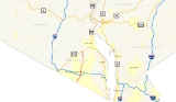
New York State Route 45 (NY 45) is a north–south state highway
in central Rockland County, New York
, United States
. It spans 8.6 miles (13.84 km) from the village of Chestnut Ridge
at the New Jersey
– New York
border, where it becomes County Route 73 (CR 73) in Bergen County, New Jersey
, to U.S. Route 202 (US 202) in the town of Haverstraw
. Though an interchange does exist between NY 45 and the Palisades Interstate Parkway
, the route has no access to the New York State Thruway
.
NY 45 was originally designated as New York State Route 305 as part of the 1930 renumbering of state highways in New York. It was renumbered to New York State Route 94 in the early 1940s before becoming NY 45 in the late 1940s.
 NY 45 begins at the New Jersey
– New York
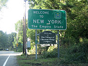
border in Chestnut Ridge
. Although the first NY 45 reassurance shield doesn't appear for a quarter-mile, the reference marker
below the "Welcome to New York" sign at the crossing indicates the beginning of NY 45.
NY 45 runs parallel to the small portion of the Garden State Parkway
(GSP) that enters New York. Officially this portion is considered an extension of the New York State Thruway
. While NY 45 never intersects the GSP, it provides a link to the parkway. South of the New Jersey border in Bergen County
, CR 73 intersects the GSP, and in New York, NY 45 intersects CR 41, which intersects the parkway. Through Chestnut Ridge (where it is known as Chestnut Ridge Road, just as CR 73, its southern extension, is in New Jersey), it crosses the New York State Thruway
.
 Once it enters Spring Valley
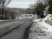
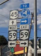
(where it is known locally first as South Main Street, then as North Main Street after it crosses its very busy intersection with NY 59), NY 45 continues northward through the downtown business district. Traffic here tends to pile up many times a day. After NY 45's intersection at Hillcrest
with CR 74
(the location of several small shopping centers), traffic tends to ease up. North of there, NY 45 provides a link to the Hassidic Jewish community of New Square
, although it never enters the village limits. At CR 80
, NY 45 enters New Hempstead
. Again the road becomes relatively quiet, but it begins to parallel the Palisades Interstate Parkway
, until its intersection at exit 12 in Pomona
. NY 45 quickly leaves Pomona and enters Mount Ivy
. This is where NY 45 comes to its northern terminus at US 202. This area of US 202 is in downtown Mount Ivy, and exit 13 of the Palisades is just 0.1 mile (0.160934 km) west of NY 45's northern terminus.
 What is now NY 45 was originally designated NY 305 as part of the 1930 renumbering of state highways in New York. At the same time, the portion of modern NY 305
north of Portville
in Cattaraugus
and Allegany
Counties was assigned NY 94, while the current NY 94
in Orange County
was designated NY 45. The NY 305 and NY 94 designations were swapped in the early 1940s, placing NY 305 on its current alignment and NY 94 on what is now NY 45. NY 94 was then swapped again, this time for NY 45, in the late 1940s, placing both routes on their modern routings.
A toll-free, limited-access highway was once planned to bypass Spring Valley
. This was planned as a "J" shaped road along the east side of the existing NY 45 and the south side of NY 59
. The southwest end would have been at the intersection of NY 59 and NY 306
in Monsey
, while the north end would have been somewhere along NY 45 in New Square
. This may have also included a northern extension of the Garden State Parkway
. However, it was cancelled due to public opposition.
State highway
State highway, state road or state route can refer to one of three related concepts, two of them related to a state or provincial government in a country that is divided into states or provinces :#A...
in central Rockland County, New York
Rockland County, New York
Rockland County is a suburban county 15 miles to the northwest of Manhattan and part of the New York City Metropolitan Area, in the U.S. state of New York. It is the southernmost county in New York west of the Hudson River, and the smallest county in New York outside of New York City. The...
, United States
United States
The United States of America is a federal constitutional republic comprising fifty states and a federal district...
. It spans 8.6 miles (13.84 km) from the village of Chestnut Ridge
Chestnut Ridge, New York
Chestnut Ridge is a village in the Town of Ramapo Rockland County, New York, United States located north of the state of New Jersey; east of Monsey; south of Spring Valley and west of Nanuet. The population was 7,829 at the 2000 census....
at the New Jersey
New Jersey
New Jersey is a state in the Northeastern and Middle Atlantic regions of the United States. , its population was 8,791,894. It is bordered on the north and east by the state of New York, on the southeast and south by the Atlantic Ocean, on the west by Pennsylvania and on the southwest by Delaware...
– New York
New York
New York is a state in the Northeastern region of the United States. It is the nation's third most populous state. New York is bordered by New Jersey and Pennsylvania to the south, and by Connecticut, Massachusetts and Vermont to the east...
border, where it becomes County Route 73 (CR 73) in Bergen County, New Jersey
Bergen County, New Jersey
Bergen County is the most populous county of the state of New Jersey, United States. As of the 2010 United States Census, its population was 905,116. The county is part of the New York City Metropolitan Area. Its county seat is Hackensack...
, to U.S. Route 202 (US 202) in the town of Haverstraw
Haverstraw (town), New York
Haverstraw is a town in Rockland County, New York, United States located north of the Town of Clarkstown and the Town of Ramapo; east of Orange County, New York; south of the Town of Stony Point and west of the Hudson River. The town runs from the west to the east border of the county in its...
. Though an interchange does exist between NY 45 and the Palisades Interstate Parkway
Palisades Interstate Parkway
The Palisades Interstate Parkway is a long limited-access highway in the U.S. states of New Jersey and New York. The parkway is a major commuter route into New York City from Rockland and Orange counties in New York and Bergen County in New Jersey...
, the route has no access to the New York State Thruway
New York State Thruway
The New York State Thruway is a system of limited-access highways located within the state of New York in the United States. The system, known officially as the Governor Thomas E. Dewey Thruway for former New York Governor Thomas E. Dewey, is operated by the New York State Thruway Authority and...
.
NY 45 was originally designated as New York State Route 305 as part of the 1930 renumbering of state highways in New York. It was renumbered to New York State Route 94 in the early 1940s before becoming NY 45 in the late 1940s.
Route description
New Jersey
New Jersey is a state in the Northeastern and Middle Atlantic regions of the United States. , its population was 8,791,894. It is bordered on the north and east by the state of New York, on the southeast and south by the Atlantic Ocean, on the west by Pennsylvania and on the southwest by Delaware...
– New York
New York
New York is a state in the Northeastern region of the United States. It is the nation's third most populous state. New York is bordered by New Jersey and Pennsylvania to the south, and by Connecticut, Massachusetts and Vermont to the east...
border in Chestnut Ridge
Chestnut Ridge, New York
Chestnut Ridge is a village in the Town of Ramapo Rockland County, New York, United States located north of the state of New Jersey; east of Monsey; south of Spring Valley and west of Nanuet. The population was 7,829 at the 2000 census....
. Although the first NY 45 reassurance shield doesn't appear for a quarter-mile, the reference marker
Reference marker (New York)
In New York, a reference marker is a small green sign mounted approximately every one-tenth mile on highways maintained by the New York State Department of Transportation. This was initiated in response to the Highway Safety Act of 1966 enacted by Congress, in an effort to monitor traffic and...
below the "Welcome to New York" sign at the crossing indicates the beginning of NY 45.
NY 45 runs parallel to the small portion of the Garden State Parkway
Garden State Parkway
The Garden State Parkway is a 172.4-mile limited-access toll parkway that stretches the length of New Jersey from the New York line at Montvale, New Jersey, to Cape May at New Jersey's southernmost tip. Its name refers to New Jersey's nickname, the "Garden State." Most New Jersey residents refer...
(GSP) that enters New York. Officially this portion is considered an extension of the New York State Thruway
New York State Thruway
The New York State Thruway is a system of limited-access highways located within the state of New York in the United States. The system, known officially as the Governor Thomas E. Dewey Thruway for former New York Governor Thomas E. Dewey, is operated by the New York State Thruway Authority and...
. While NY 45 never intersects the GSP, it provides a link to the parkway. South of the New Jersey border in Bergen County
Bergen County, New Jersey
Bergen County is the most populous county of the state of New Jersey, United States. As of the 2010 United States Census, its population was 905,116. The county is part of the New York City Metropolitan Area. Its county seat is Hackensack...
, CR 73 intersects the GSP, and in New York, NY 45 intersects CR 41, which intersects the parkway. Through Chestnut Ridge (where it is known as Chestnut Ridge Road, just as CR 73, its southern extension, is in New Jersey), it crosses the New York State Thruway
New York State Thruway
The New York State Thruway is a system of limited-access highways located within the state of New York in the United States. The system, known officially as the Governor Thomas E. Dewey Thruway for former New York Governor Thomas E. Dewey, is operated by the New York State Thruway Authority and...
.
Spring Valley, New York
Spring Valley, incorporated on July 9, 1902 is a village spanning the Town of Ramapo and Town of Clarkstown in Rockland County, New York, United States located north of Nanuet; east of Airmont and Monsey; south of Hillcrest and west of West Nyack...
(where it is known locally first as South Main Street, then as North Main Street after it crosses its very busy intersection with NY 59), NY 45 continues northward through the downtown business district. Traffic here tends to pile up many times a day. After NY 45's intersection at Hillcrest
Hillcrest, New York
Hillcrest is a hamlet , in the Town of Ramapo, Rockland County, New York, United States located north of Spring Valley; east of Viola; south of New Square and New Hempstead and west of New City...
with CR 74
County Route 74 (Rockland County, New York)
County Route 74 is a long west–east county route in the central part of Rockland County, New York. CR 74 begins at US 202 in Montebello, near Harriman State Park, and ends at CR 35A in New City. CR 74 is an alternate route to County Route 80, as it runs...
(the location of several small shopping centers), traffic tends to ease up. North of there, NY 45 provides a link to the Hassidic Jewish community of New Square
New Square, New York
New Square is an all-Hasidic village in the Town of Ramapo, Rockland County, New York, United States located north of Hillcrest; east of Viola; south of New Hempstead and west of New City...
, although it never enters the village limits. At CR 80
County Route 80 (Rockland County, New York)
County Route 80 is a west–east county route in the central part of Rockland County, New York. CR 80 serves as an alternative route for NY 59 and the New York State Thruway . In fact, CR 80 is the only route besides those two major routes that runs completely from the...
, NY 45 enters New Hempstead
New Hempstead, New York
New Hempstead, formally known as Kakiat , is a village in the Town of Ramapo, Rockland County, New York, United States located north of New Square; east of Wesley Hills; south of Pomona and west of New City...
. Again the road becomes relatively quiet, but it begins to parallel the Palisades Interstate Parkway
Palisades Interstate Parkway
The Palisades Interstate Parkway is a long limited-access highway in the U.S. states of New Jersey and New York. The parkway is a major commuter route into New York City from Rockland and Orange counties in New York and Bergen County in New Jersey...
, until its intersection at exit 12 in Pomona
Pomona, New York
Pomona is a village partly in the Town of Ramapo and partly in the Town of Haverstraw in Rockland County, New York, United States, located north of New Hempstead, east of Harriman State Park, north of Monsey and west of Mount Ivy. According to the 2010 Census, the population was 3,103, a 13 percent...
. NY 45 quickly leaves Pomona and enters Mount Ivy
Mount Ivy, New York
Mount Ivy is a hamlet in the towns of Haverstraw and Ramapo New York, United States located north of New City; east of Pomona; south of Thiells and west of the Garnerville...
. This is where NY 45 comes to its northern terminus at US 202. This area of US 202 is in downtown Mount Ivy, and exit 13 of the Palisades is just 0.1 mile (0.160934 km) west of NY 45's northern terminus.
History
New York State Route 305
New York State Route 305 is a north–south route in the Southern Tier that runs from the Pennsylvania state line in Cattaraugus County to the hamlet of Belfast in Allegany County, where it ends at NY 19...
north of Portville
Portville (village), New York
Portville is a village in Cattaraugus County, New York, USA. The population was 1,024 at the 2000 census. The Village of Portville is within the south part of the Town of Portville and southeast of Olean, New York.- History :...
in Cattaraugus
Cattaraugus County, New York
Cattaraugus County is a county located in the U.S. state of New York. As of the 2010 census, the population was 80,317. The county seat is Little Valley.-History:...
and Allegany
Allegany County, New York
Allegany County is a county located in the U.S. state of New York. As of the 2010 census, the population was 48,946. Its name derives from a Delaware Indian word, applied by settlers of Western New York State to a trail that followed the Allegheny River. Its county seat is...
Counties was assigned NY 94, while the current NY 94
New York State Route 94
New York State Route 94 is a state highway entirely within Orange County in southern New York. The western terminus is at the New York-New Jersey state line, where it continues as NJ 94 for another to Columbia, New Jersey. Its eastern terminus is located at U.S. Route 9W in New Windsor....
in Orange County
Orange County, New York
Orange County is a county located in the U.S. state of New York. It is part of the Poughkeepsie–Newburgh–Middletown, NY Metropolitan Statistical Area and is located at the northern reaches of the New York metropolitan area. The county sits in the state's scenic Mid-Hudson Region of the Hudson Valley...
was designated NY 45. The NY 305 and NY 94 designations were swapped in the early 1940s, placing NY 305 on its current alignment and NY 94 on what is now NY 45. NY 94 was then swapped again, this time for NY 45, in the late 1940s, placing both routes on their modern routings.
A toll-free, limited-access highway was once planned to bypass Spring Valley
Spring Valley, New York
Spring Valley, incorporated on July 9, 1902 is a village spanning the Town of Ramapo and Town of Clarkstown in Rockland County, New York, United States located north of Nanuet; east of Airmont and Monsey; south of Hillcrest and west of West Nyack...
. This was planned as a "J" shaped road along the east side of the existing NY 45 and the south side of NY 59
New York State Route 59
New York State Route 59 is an east–west state highway in southern Rockland County, New York, in the United States. The route extends for from NY 17 in Hillburn to U.S. Route 9W in Nyack. In Suffern, it has a concurrency with US 202 for . NY 59 runs parallel to the New...
. The southwest end would have been at the intersection of NY 59 and NY 306
New York State Route 306
New York State Route 306 is a north–south state highway in western Rockland County, New York in the United States. NY 306 runs from NY 59 in the hamlet of Monsey to U.S. Route 202 in Ladentown, on the western boundary of the village of Pomona...
in Monsey
Monsey, New York
Monsey is a hamlet , in the Town of Ramapo, Rockland County, New York, United States located north of the state of New Jersey; east of Suffern; south of Airmont and west of Nanuet...
, while the north end would have been somewhere along NY 45 in New Square
New Square, New York
New Square is an all-Hasidic village in the Town of Ramapo, Rockland County, New York, United States located north of Hillcrest; east of Viola; south of New Hempstead and west of New City...
. This may have also included a northern extension of the Garden State Parkway
Garden State Parkway
The Garden State Parkway is a 172.4-mile limited-access toll parkway that stretches the length of New Jersey from the New York line at Montvale, New Jersey, to Cape May at New Jersey's southernmost tip. Its name refers to New Jersey's nickname, the "Garden State." Most New Jersey residents refer...
. However, it was cancelled due to public opposition.