
New York State Route 312
Encyclopedia
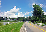
New York State Route 312 (NY 312) is a short but important state highway
located entirely within the town of Southeast
in Putnam County
, New York
in the United States
. It allows access, albeit indirectly, to the village of Brewster
from Interstate 84
(I-84) via a less complicated exit than the nearby I-684
exit, and is often heavily used for this purpose at rush hour
by local residents. The western terminus of the route is at U.S. Route 6 (US 6) roughly 2 miles (3.2 km) northwest of Brewster. The eastern terminus is at NY 22
in the hamlet of Sears Corners. NY 312 was originally assigned to what is now NY 164
as part of the 1930 renumbering of state highways in New York before being shifted south to its current location ca. 1937.
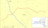
 NY 312 begins at US 6
in Southeast, New York
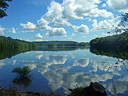
just northeast of Middle Branch Reservoir
, one of the many reservoirs in Putnam County
which supply New York City
's large need for drinking water. The route heads northeast, before veering to the north after a 0.5 mile (0.8 km) to bypass a hill 680 feet (207.3 m) high. Past the hill, the route curves eastward then northeastward as it meets I-84
by way of an interchange and approaches the hamlet of Dykemans.
In Dykemans, NY 312 serves the Metro-North Railroad
's Southeast
station, located on the railroad's Harlem Line. Just north of the station, NY 312 turns almost due east as it crosses the Harlem Line at-grade
and exits Dykemans. 0.5 mile (0.80467 km) from the railroad crossing, the route intersects North Brewster Road (County Road 58 or CR 58) and Farm to Market Road (CR 62) in the hamlet of Brewster Hill
. From here, it travels along the northern edge of Bog Brook Reservoir
, another large reservoir which supplies drinking water to New York City. NY 312 proceeds east to the hamlet of Sears Corners, where it terminates at NY 22
.
in the 1930 renumbering of state highways in New York. At the same time, the NY 312 designation was assigned to the entirety of what is now NY 164
. The NY 312 designation was shifted 3 miles (5 km) southward to its current alignment ca. 1937 after NY 52 was truncated to Carmel
. No changes have been made to NY 312's alignment since that time.
State highway
State highway, state road or state route can refer to one of three related concepts, two of them related to a state or provincial government in a country that is divided into states or provinces :#A...
located entirely within the town of Southeast
Southeast, New York
Southeast is a town in Putnam County, New York, United States. The population was 17,316 at the 2000 census. The town is in the southeast part of the county. Interstate 84, Interstate 684, US Route 202, and US Route 6 pass through the town.- History :...
in Putnam County
Putnam County, New York
Putnam County is a county located in the U.S. state of New York, in the lower Hudson River Valley. Putnam county formed in 1812, when it detached from Dutchess County. , the population was 99,710. It is part of the New York Metropolitan Area. The county seat is the hamlet of Carmel...
, New York
New York
New York is a state in the Northeastern region of the United States. It is the nation's third most populous state. New York is bordered by New Jersey and Pennsylvania to the south, and by Connecticut, Massachusetts and Vermont to the east...
in the United States
United States
The United States of America is a federal constitutional republic comprising fifty states and a federal district...
. It allows access, albeit indirectly, to the village of Brewster
Brewster, New York
Brewster is a village within the town of Southeast in Putnam County, New York, United States. Its population was 2,162 at the 2000 census. The village is the most densely populated portion of the town...
from Interstate 84
Interstate 84 in New York
Interstate 84 is a part of the Interstate Highway System that runs from Dunmore, Pennsylvania, to Sturbridge, Massachusetts, in the Eastern United States. In New York, I-84 extends from the Pennsylvania state line at Port Jervis to the Connecticut state line east of Brewster...
(I-84) via a less complicated exit than the nearby I-684
Interstate 684
Interstate 684 is a 28.4 mile-long north–south Interstate Highway in the states of New York and Connecticut. The highway connects I-84 with I-287 and the Hutchinson River Parkway, primarily serving commuter traffic to and from the northern suburbs of the New York metropolitan area...
exit, and is often heavily used for this purpose at rush hour
Rush hour
A rush hour or peak hour is a part of the day during which traffic congestion on roads and crowding on public transport is at its highest. Normally, this happens twice a day—once in the morning and once in the evening, the times during when the most people commute...
by local residents. The western terminus of the route is at U.S. Route 6 (US 6) roughly 2 miles (3.2 km) northwest of Brewster. The eastern terminus is at NY 22
New York State Route 22
New York State Route 22 is a north–south state highway in eastern New York in the United States. It runs parallel to the state's eastern edge from the outskirts of New York City to a short distance south of the Canadian border. At , it is the state's longest north–south route and...
in the hamlet of Sears Corners. NY 312 was originally assigned to what is now NY 164
New York State Route 164
New York State Route 164 is a short state highway located entirely in the town of Patterson in northeastern Putnam County, New York, United States. It is a short, two-lane back road that does not pass through any major populated areas and serves primarily as a connector between NY 311...
as part of the 1930 renumbering of state highways in New York before being shifted south to its current location ca. 1937.
Route description
U.S. Route 6 in New York
U.S. Route 6 is a part of the U.S. Highway System that runs from Bishop, California, to Provincetown, Massachusetts. In New York, US 6 extends from the Pennsylvania state line at Port Jervis to the Connecticut state line east of Brewster...
in Southeast, New York
Southeast, New York
Southeast is a town in Putnam County, New York, United States. The population was 17,316 at the 2000 census. The town is in the southeast part of the county. Interstate 84, Interstate 684, US Route 202, and US Route 6 pass through the town.- History :...
just northeast of Middle Branch Reservoir
Middle Branch Reservoir
Middle Branch Reservoir is among the 12 reservoirs in New York City's Croton watershed. It is located in the Town of Southeast in Putnam County, 35 miles north of the city....
, one of the many reservoirs in Putnam County
Putnam County, New York
Putnam County is a county located in the U.S. state of New York, in the lower Hudson River Valley. Putnam county formed in 1812, when it detached from Dutchess County. , the population was 99,710. It is part of the New York Metropolitan Area. The county seat is the hamlet of Carmel...
which supply New York City
New York City
New York is the most populous city in the United States and the center of the New York Metropolitan Area, one of the most populous metropolitan areas in the world. New York exerts a significant impact upon global commerce, finance, media, art, fashion, research, technology, education, and...
's large need for drinking water. The route heads northeast, before veering to the north after a 0.5 mile (0.8 km) to bypass a hill 680 feet (207.3 m) high. Past the hill, the route curves eastward then northeastward as it meets I-84
Interstate 84 in New York
Interstate 84 is a part of the Interstate Highway System that runs from Dunmore, Pennsylvania, to Sturbridge, Massachusetts, in the Eastern United States. In New York, I-84 extends from the Pennsylvania state line at Port Jervis to the Connecticut state line east of Brewster...
by way of an interchange and approaches the hamlet of Dykemans.
In Dykemans, NY 312 serves the Metro-North Railroad
Metro-North Railroad
The Metro-North Commuter Railroad , trading as MTA Metro-North Railroad, or, more commonly, Metro-North, is a suburban commuter rail service that is run and managed by the Metropolitan Transportation Authority , an authority of New York State. It is the busiest commuter railroad in the United...
's Southeast
Southeast (Metro-North station)
Southeast is a Metro-North Railroad station serving the residents of Southeast, New York via the Harlem Line. Trains leave for New York City every hour, and about every 30 minutes during rush hour. It is the terminus of the Harlem Line electrified service. For travel farther north to Wassaic,...
station, located on the railroad's Harlem Line. Just north of the station, NY 312 turns almost due east as it crosses the Harlem Line at-grade
Level crossing
A level crossing occurs where a railway line is intersected by a road or path onone level, without recourse to a bridge or tunnel. It is a type of at-grade intersection. The term also applies when a light rail line with separate right-of-way or reserved track crosses a road in the same fashion...
and exits Dykemans. 0.5 mile (0.80467 km) from the railroad crossing, the route intersects North Brewster Road (County Road 58 or CR 58) and Farm to Market Road (CR 62) in the hamlet of Brewster Hill
Brewster Hill, New York
Brewster Hill is a hamlet located in the township of Southeast in Putnam County, New York. As of the 2000 census, the population was 2,226.Brewster Hill is located on the east side of Tonetta Lake and is east of Interstate 84....
. From here, it travels along the northern edge of Bog Brook Reservoir
Bog Brook Reservoir
The Bog Brook Reservoir is a reservoir in the Croton Watershed in southern New York State. It is located in the town of Southeast, New York in Putnam County, and is approximately 38 miles north of New York City, to which it supplies water...
, another large reservoir which supplies drinking water to New York City. NY 312 proceeds east to the hamlet of Sears Corners, where it terminates at NY 22
New York State Route 22
New York State Route 22 is a north–south state highway in eastern New York in the United States. It runs parallel to the state's eastern edge from the outskirts of New York City to a short distance south of the Canadian border. At , it is the state's longest north–south route and...
.
History
All of modern NY 312 was originally designated as part of NY 52New York State Route 52
New York State Route 52 is a long state highway in the southeastern part of New York in the United States. It generally runs from west to east, beginning at the Pennsylvania state line in the Delaware River near Narrowsburg, crossing the Hudson River on the Newburgh-Beacon Bridge, and ending...
in the 1930 renumbering of state highways in New York. At the same time, the NY 312 designation was assigned to the entirety of what is now NY 164
New York State Route 164
New York State Route 164 is a short state highway located entirely in the town of Patterson in northeastern Putnam County, New York, United States. It is a short, two-lane back road that does not pass through any major populated areas and serves primarily as a connector between NY 311...
. The NY 312 designation was shifted 3 miles (5 km) southward to its current alignment ca. 1937 after NY 52 was truncated to Carmel
Carmel, New York
Carmel is a town located in Putnam County, New York, USA. As of the 2000 census, the town had a total population of 36,465.There are no incorporated villages in the town, although the hamlets of Carmel and Mahopac each have populations sizable enough to be thought of as villages.The Town of Carmel...
. No changes have been made to NY 312's alignment since that time.