
New York State Route 164
Encyclopedia
New York State Route 164 (NY 164) is a short state highway
located entirely in the town of Patterson
in northeastern Putnam County
, New York
, United States
. It is a short, two-lane back road that does not pass through any major populated areas and serves primarily as a connector between NY 311
and NY 22
. NY 164 also allows for faster passage from Interstate 84
(I-84) to the Putnam Lake
area via NY 311. The route was originally designated as NY 312
during the 1930s and later became part of NY 216
. NY 164 was established on January 1, 1970, following the truncation of NY 216 to its current eastern terminus.
a short distance north of I-84
. It crosses under the Metro North
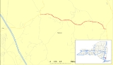
tracks three times, including two one-lane underpasses with limited sight to the other side. It passes along the northern base of a small mountain and turns slightly southward. The highway turns due eastward and intersects with County Route 64 in the hamlet of Towners. Just to the north is Mandel Pond, and the route makes a series of erratic turns around small mountains, passing south of Cornwall Hill as it does so. Route 164 turns south-southeast and ends at NY 22
in Patterson
, east of the East Branch Croton River
.
in the 1930 renumbering of state highways in New York. When the NY 312 designation was shifted south to its current location in the town of Southeast
ca. 1937, its former routing in Patterson
became part of an extended NY 216
, which connected with its current routing by way of modern NY 311
, NY 292
and NY 55
. NY 216 was truncated to its current length on January 1, 1970. The portion of its former alignment between NY 311 and NY 22
was then redesignated as NY 164.
State highway
State highway, state road or state route can refer to one of three related concepts, two of them related to a state or provincial government in a country that is divided into states or provinces :#A...
located entirely in the town of Patterson
Patterson, New York
Patterson is a town in Putnam County, New York, United States. The town is in the northeast part of the county. Interstate 84 passes through the southwest part of the town. The population was 11,306 at the 2000 census. The town is named after early farmer Matthew Paterson...
in northeastern Putnam County
Putnam County, New York
Putnam County is a county located in the U.S. state of New York, in the lower Hudson River Valley. Putnam county formed in 1812, when it detached from Dutchess County. , the population was 99,710. It is part of the New York Metropolitan Area. The county seat is the hamlet of Carmel...
, New York
New York
New York is a state in the Northeastern region of the United States. It is the nation's third most populous state. New York is bordered by New Jersey and Pennsylvania to the south, and by Connecticut, Massachusetts and Vermont to the east...
, United States
United States
The United States of America is a federal constitutional republic comprising fifty states and a federal district...
. It is a short, two-lane back road that does not pass through any major populated areas and serves primarily as a connector between NY 311
New York State Route 311
New York State Route 311 is a state highway located entirely within Putnam County, New York, United States. The highway begins at NY 52 in Lake Carmel, and intersects Interstate 84 shortly thereafter...
and NY 22
New York State Route 22
New York State Route 22 is a north–south state highway in eastern New York in the United States. It runs parallel to the state's eastern edge from the outskirts of New York City to a short distance south of the Canadian border. At , it is the state's longest north–south route and...
. NY 164 also allows for faster passage from Interstate 84
Interstate 84 (east)
Interstate 84 is an Interstate Highway extending from Dunmore, Pennsylvania at an interchange with Interstate 81 to Sturbridge, Massachusetts, at an interchange with the Massachusetts Turnpike . I-84 has mile-log junction numbering in Pennsylvania; otherwise, exit numbers are roughly sequential...
(I-84) to the Putnam Lake
Putnam Lake, New York
Putnam Lake is a hamlet and census-designated place located in the eastern part of the Town of Patterson in Putnam County, New York, United States. As of the 2000 census, the population was 3,855. Putnam Lake is adjacent to the Connecticut border, which is crossed by a number of local streets...
area via NY 311. The route was originally designated as NY 312
New York State Route 312
New York State Route 312 is a short but important state highway located entirely within the town of Southeast in Putnam County, New York in the United States...
during the 1930s and later became part of NY 216
New York State Route 216
New York State Route 216 is a short state highway located entirely in Dutchess County, New York, United States. At in length, it connects NY 52 and NY 55 between the hamlets of Stormville at the east end and Poughquag at the west...
. NY 164 was established on January 1, 1970, following the truncation of NY 216 to its current eastern terminus.
Route description
In the west, NY 164 splits off from NY 311New York State Route 311
New York State Route 311 is a state highway located entirely within Putnam County, New York, United States. The highway begins at NY 52 in Lake Carmel, and intersects Interstate 84 shortly thereafter...
a short distance north of I-84
Interstate 84 (east)
Interstate 84 is an Interstate Highway extending from Dunmore, Pennsylvania at an interchange with Interstate 81 to Sturbridge, Massachusetts, at an interchange with the Massachusetts Turnpike . I-84 has mile-log junction numbering in Pennsylvania; otherwise, exit numbers are roughly sequential...
. It crosses under the Metro North
Harlem Line (Metro-North)
Metro-North's Harlem Line, originally chartered as the New York & Harlem Railroad, is an 82-mile commuter rail line running north from New York City into eastern Dutchess County...
tracks three times, including two one-lane underpasses with limited sight to the other side. It passes along the northern base of a small mountain and turns slightly southward. The highway turns due eastward and intersects with County Route 64 in the hamlet of Towners. Just to the north is Mandel Pond, and the route makes a series of erratic turns around small mountains, passing south of Cornwall Hill as it does so. Route 164 turns south-southeast and ends at NY 22
New York State Route 22
New York State Route 22 is a north–south state highway in eastern New York in the United States. It runs parallel to the state's eastern edge from the outskirts of New York City to a short distance south of the Canadian border. At , it is the state's longest north–south route and...
in Patterson
Patterson, New York
Patterson is a town in Putnam County, New York, United States. The town is in the northeast part of the county. Interstate 84 passes through the southwest part of the town. The population was 11,306 at the 2000 census. The town is named after early farmer Matthew Paterson...
, east of the East Branch Croton River
East Branch Croton River
The East Branch Croton River is a river in southern New York state.It rises in the town of Pawling in Dutchess County, flowing west and then south through the village of Pawling. It crosses into Putnam County, flowing through the Great Swamp in the town of Patterson...
.
History
The entirety of modern-day NY 164 was originally designated as NY 312New York State Route 312
New York State Route 312 is a short but important state highway located entirely within the town of Southeast in Putnam County, New York in the United States...
in the 1930 renumbering of state highways in New York. When the NY 312 designation was shifted south to its current location in the town of Southeast
Southeast, New York
Southeast is a town in Putnam County, New York, United States. The population was 17,316 at the 2000 census. The town is in the southeast part of the county. Interstate 84, Interstate 684, US Route 202, and US Route 6 pass through the town.- History :...
ca. 1937, its former routing in Patterson
Patterson, New York
Patterson is a town in Putnam County, New York, United States. The town is in the northeast part of the county. Interstate 84 passes through the southwest part of the town. The population was 11,306 at the 2000 census. The town is named after early farmer Matthew Paterson...
became part of an extended NY 216
New York State Route 216
New York State Route 216 is a short state highway located entirely in Dutchess County, New York, United States. At in length, it connects NY 52 and NY 55 between the hamlets of Stormville at the east end and Poughquag at the west...
, which connected with its current routing by way of modern NY 311
New York State Route 311
New York State Route 311 is a state highway located entirely within Putnam County, New York, United States. The highway begins at NY 52 in Lake Carmel, and intersects Interstate 84 shortly thereafter...
, NY 292
New York State Route 292
New York State Route 292 is a short state highway in the Hudson Valley of New York, United States, bridging Putnam and Dutchess Counties. The southern terminus of the route is at an intersection with NY 311 in the town of Patterson, and the northern terminus is at a junction with...
and NY 55
New York State Route 55
New York State Route 55 is a state highway in southern New York, running from the Pennsylvania state line at the Delaware River in Barryville to the Connecticut state line at Wingdale...
. NY 216 was truncated to its current length on January 1, 1970. The portion of its former alignment between NY 311 and NY 22
New York State Route 22
New York State Route 22 is a north–south state highway in eastern New York in the United States. It runs parallel to the state's eastern edge from the outskirts of New York City to a short distance south of the Canadian border. At , it is the state's longest north–south route and...
was then redesignated as NY 164.