
Scottsville, New York
Encyclopedia
Scottsville is a village
in southwestern Monroe County
, New York
, United States
, and is in the northeastern part of the Town of Wheatland
. The population was 2,128 at the 2000 census. The village is named after an early settler, Isaac Scott
. Most Scottsvillians work in and around the city of Rochester, New York—the village of Scottsville is located about a ten minute drive from the outer limits of the city.
The following sites are on the National Register of Historic Places
: Isaac Cox Cobblestone Farmstead
, Grace Church
, David McVean House
, Simeon Sage House
, William Shirts House
, Union Presbyterian Church
, and Windom Hall. The Rochester Street Historic District
is a national historic district
listed in 1973.
The village is located one mile (1.6 km) west of the junction of Oatka Creek
and the Genesee River
.
According to the United States Census Bureau
, the village has a total area of 1.1 square miles (2.8 km²), all of it land.
of 2000, there were 2,128 people, 835 households, and 591 families residing in the village. The population density
was 1,968.1 people per square mile (760.8/km²). There were 852 housing units at an average density of 788.0 per square mile (304.6/km²). The racial makeup of the village was 91.92% White, 4.32% African American, 0.66% Native American, 0.56% Asian, 0.14% Pacific Islander, 1.08% from other races
, and 1.32% from two or more races. Hispanic or Latino of any race were 2.96% of the population.
There were 835 households out of which 34.7% had children under the age of 18 living with them, 57.0% were married couples
living together, 11.0% had a female householder with no husband present, and 29.2% were non-families. 24.9% of all households were made up of individuals and 10.1% had someone living alone who was 65 years of age or older. The average household size was 2.53 and the average family size was 3.05.
In the village the population was spread out with 28.1% under the age of 18, 5.8% from 18 to 24, 28.6% from 25 to 44, 24.4% from 45 to 64, and 13.2% who were 65 years of age or older. The median age was 38 years. For every 100 females there were 93.6 males. For every 100 females age 18 and over, there were 86.0 males.
The median income for a household in the village was $52,472, and the median income for a family was $61,316. Males had a median income of $43,250 versus $30,781 for females. The per capita income
for the village was $24,831. About 1.2% of families and 2.3% of the population were below the poverty line, including 1.7% of those under age 18 and 1.2% of those age 65 or over.
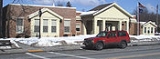
 Village government is headed by the mayor and the Board of Trustees and is located in a recently renovated building at 22 Main Street.
, and include an elementary school, middle school and high school.
Village
A village is a clustered human settlement or community, larger than a hamlet with the population ranging from a few hundred to a few thousand , Though often located in rural areas, the term urban village is also applied to certain urban neighbourhoods, such as the West Village in Manhattan, New...
in southwestern Monroe County
Monroe County, New York
Monroe County is a county located in the U.S. state of New York. As of the 2010 census, the population was 744,344. It is named after James Monroe, fifth President of the United States of America. Its county seat is the city of Rochester....
, New York
New York
New York is a state in the Northeastern region of the United States. It is the nation's third most populous state. New York is bordered by New Jersey and Pennsylvania to the south, and by Connecticut, Massachusetts and Vermont to the east...
, United States
United States
The United States of America is a federal constitutional republic comprising fifty states and a federal district...
, and is in the northeastern part of the Town of Wheatland
Wheatland, New York
Wheatland is a town in Monroe County, New York, United States. The population was 4,775 at the 2010 census. The town is home to Genesee Country Village and Museum.The Town of Wheatland is located in the southwest part of the county....
. The population was 2,128 at the 2000 census. The village is named after an early settler, Isaac Scott
Isaac Scott
Isaac Scott was a pioneer, farmer, and tavern owner. He is considered the founder of Scottsville, New York, as his farmland took up the majority of the modern village....
. Most Scottsvillians work in and around the city of Rochester, New York—the village of Scottsville is located about a ten minute drive from the outer limits of the city.
History
Isaac Scott, one of the first settlers, arrived in 1790 and purchased 150 acre (0.607029 km²) of land from owners who lived in London and Great Britain. This land covered much of what is now the village of Scottsville. Scott's log house was at the southwest corner of Main and Rochester Streets in the village.The following sites are on the National Register of Historic Places
National Register of Historic Places
The National Register of Historic Places is the United States government's official list of districts, sites, buildings, structures, and objects deemed worthy of preservation...
: Isaac Cox Cobblestone Farmstead
Isaac Cox Cobblestone Farmstead
Isaac Cox Cobblestone Farmstead, also known as the Letson Farm, is a historic home and farm complex located in the town of Wheatland near Scottsville in Monroe County, New York. The complex includes a Federal style cobblestone farmhouse built about 1838. It is constructed of small to medium sized...
, Grace Church
Grace Church (Scottsville, New York)
Grace Church is a historic Episcopal church located at Scottsville in Monroe County, New York. The church was designed by noted Rochester architect Harvey Ellis and built in 1885. It is in the Latin cross form in the Richardsonian Romanesque style. It has a native fieldstone lower level with an...
, David McVean House
David McVean House
David McVean House, also known as the McVean-Jones-Reeves House, is a historic home located at Scottsville in Monroe County, New York. It is a brick vernacular Federal-style house on a pargeted cut-stone foundation...
, Simeon Sage House
Simeon Sage House
Simeon Sage House is a historic home located at Scottsville in Monroe County, New York. It was built about 1830 and consists of a 1-story, five-by-two-bay, rectangular main block with a smaller 1-story rectangular rear wing in a vernacular Federal style. There are later Greek Revival style...
, William Shirts House
William Shirts House
William Shirts House, also known as Camperdown Farm, is a historic home located at Scottsville in Monroe County, New York. The vernacular Federal-style house was built about 1825. It is composed of a 2-story, four-by-two-bay, main block with a 2-story rear wing.It was listed on the National...
, Union Presbyterian Church
Union Presbyterian Church (Scottsville, New York)
Union Presbyterian Church, also known as First Presbyterian Church of Wheatland, is a historic Presbyterian church located at Scottsville in Monroe County, New York. It is a mid-19th-century vernacular Romanesque Revival–style building...
, and Windom Hall. The Rochester Street Historic District
Rochester Street Historic District
Rochester Street Historic District is a national historic district located at Scottsville in Monroe County, New York. The district encompasses 41 residential structures, over half of which date from the 1830s through 1850s and are distinct examples of Greek Revival architecture.It was listed on...
is a national historic district
Historic district (United States)
In the United States, a historic district is a group of buildings, properties, or sites that have been designated by one of several entities on different levels as historically or architecturally significant. Buildings, structures, objects and sites within a historic district are normally divided...
listed in 1973.
Geography
Scottsville is located at 43°1′19"N 77°45′13"W (43.021813, -77.753545).The village is located one mile (1.6 km) west of the junction of Oatka Creek
Oatka Creek
Oatka Creek is the third longest tributary of the Genesee River, located entirely in the Western New York region of the U.S. state of New York. From southern Wyoming County, it flows to the Genesee near Scottsville, draining an area of that includes all or part of 23 towns and villages in...
and the Genesee River
Genesee River
The Genesee River is a North American river flowing northward through the Twin Tiers of Pennsylvania and New York. The river provided the original power for the Rochester area's 19th century mills and still provides hydroelectric power for downtown Rochester....
.
According to the United States Census Bureau
United States Census Bureau
The United States Census Bureau is the government agency that is responsible for the United States Census. It also gathers other national demographic and economic data...
, the village has a total area of 1.1 square miles (2.8 km²), all of it land.
Demographics
As of the censusCensus
A census is the procedure of systematically acquiring and recording information about the members of a given population. It is a regularly occurring and official count of a particular population. The term is used mostly in connection with national population and housing censuses; other common...
of 2000, there were 2,128 people, 835 households, and 591 families residing in the village. The population density
Population density
Population density is a measurement of population per unit area or unit volume. It is frequently applied to living organisms, and particularly to humans...
was 1,968.1 people per square mile (760.8/km²). There were 852 housing units at an average density of 788.0 per square mile (304.6/km²). The racial makeup of the village was 91.92% White, 4.32% African American, 0.66% Native American, 0.56% Asian, 0.14% Pacific Islander, 1.08% from other races
Race (United States Census)
Race and ethnicity in the United States Census, as defined by the Federal Office of Management and Budget and the United States Census Bureau, are self-identification data items in which residents choose the race or races with which they most closely identify, and indicate whether or not they are...
, and 1.32% from two or more races. Hispanic or Latino of any race were 2.96% of the population.
There were 835 households out of which 34.7% had children under the age of 18 living with them, 57.0% were married couples
Marriage
Marriage is a social union or legal contract between people that creates kinship. It is an institution in which interpersonal relationships, usually intimate and sexual, are acknowledged in a variety of ways, depending on the culture or subculture in which it is found...
living together, 11.0% had a female householder with no husband present, and 29.2% were non-families. 24.9% of all households were made up of individuals and 10.1% had someone living alone who was 65 years of age or older. The average household size was 2.53 and the average family size was 3.05.
In the village the population was spread out with 28.1% under the age of 18, 5.8% from 18 to 24, 28.6% from 25 to 44, 24.4% from 45 to 64, and 13.2% who were 65 years of age or older. The median age was 38 years. For every 100 females there were 93.6 males. For every 100 females age 18 and over, there were 86.0 males.
The median income for a household in the village was $52,472, and the median income for a family was $61,316. Males had a median income of $43,250 versus $30,781 for females. The per capita income
Per capita income
Per capita income or income per person is a measure of mean income within an economic aggregate, such as a country or city. It is calculated by taking a measure of all sources of income in the aggregate and dividing it by the total population...
for the village was $24,831. About 1.2% of families and 2.3% of the population were below the poverty line, including 1.7% of those under age 18 and 1.2% of those age 65 or over.
Local government
Education
Public schools are under the jurisdiction of the Wheatland-Chili Central School DistrictWheatland-Chili Central School District
The Wheatland-Chili Central School District is a public school district in New York State that serves approximately 600 students in the village of Scottsville and portions of the towns of Chili and Wheatland in Monroe County, with over 160 employees and an operating budget of $16 million...
, and include an elementary school, middle school and high school.