
New York State Route 18F
Encyclopedia
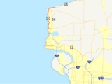
New York State Route 18F (NY 18F) is a 9.8 miles (15.77 km) long state highway
in northwestern Niagara County, New York
, United States
. The southern terminus of the route is at an interchange with NY 104
and the Robert Moses State Parkway
just east of the village of Lewiston. The northern terminus is at an intersection with NY 18
near Four Mile Creek State Park
in Porter
. NY 18F parallels NY 18 for most of its alignment, taking a more westerly course than its parent. NY 18F is the only remaining suffixed route of NY 18.
The portion of modern NY 18F south of Youngstown
was originally designated as part of NY 34 in 1924. NY 34 was absorbed into NY 18 as part of the 1930 state highway renumbering. The change was part of a larger extension of NY 18 east to Rochester
. NY 18 was realigned in the late 1940s to follow its modern alignment between Lewiston and Lake Ontario
, at which time its former routing alongside the Niagara River
became NY 18F.
 Officially, NY 18F begins at the eastern edge of the village of Lewiston at an interchange between NY 104
and the Robert Moses State Parkway
. Signage for NY 18F, however, exists as far south as the interchange between NY 104 and NY 18
south of the village. According to signage, NY 18F is concurrent to NY 104 from NY 18 north to the interchange between NY 104 and the Moses Parkway, where NY 18F and NY 104 split at the western extent of the interchange. The Seaway Trail
, routed along NY 104 from Niagara Falls
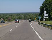
north to Lewiston, follows NY 18F west into Lewiston along the path of Ridge Road
, here named Center Street. At 4th Street, NY 18F turns northward, following 4th Street for four blocks to Oneida Street. NY 18F cuts west on Oneida for two blocks before continuing northward out of the village on 2nd Street.
 North of the Lewiston village limits, NY 18F is the closest roadway to the Niagara River
, a trait reflected in its name of Lower River Road. As it progresses northward along the eastern bank of the river, NY 18F parallels both the Robert Moses State Parkway and NY 18. At Stella Niagara, NY 18F meets Fletcher Road, the first road north of Lewiston that provides a connection to all three roadways. NY 18F continues on, passing through the western extent of Joseph Davis State Park
south of the village of Youngstown
in the town of Porter
. In Youngstown, NY 18F becomes Main Street and intersects the western terminus of NY 93
in the village center. At the northern fringe of the community, NY 18F intersects the southern entrance to the Fort Niagara State Park
. NY 18F bypasses the park, turning east onto Jackson Street, then north onto Lake Road as it follows the perimeter of the park.
Near the Lake Ontario
shoreline, NY 18F connects to the Fort Niagara
spur of the Robert Moses State Parkway via a partial diamond interchange
. Only westbound access is permitted at the location; access to the eastbound spur, and thus the parkway mainline, is provided via NY 93 in Youngstown or by NY 18 farther east. Past the exit, NY 18F turns east and begins to parallel the lakeshore. The route also parallels the mainline Moses Parkway for a short distance before curving south to cross over the parkway and terminate at NY 18 in the vicinity of Four Mile Creek State Park
in Porter.
Ownership and maintenance of NY 18F is split between three different entities. The section of NY 18F from Center Street in Lewiston to the northern village line of Youngstown is maintained by Niagara County
. From Main Street in Youngstown to the northern village line, NY 18F is concurrent
to the unsigned County Route 138 (CR 138); the remainder of the county-maintained segment is co-designated as CR 907. All of NY 18F north of Youngstown is maintained by the town of Porter while the rest—Center Street between NY 104 and 4th Street—is maintained by the New York State Department of Transportation
.
was originally designated as part of NY 34 in 1924. In the 1930 state highway renumbering, NY 34 became part of NY 18, which was extended north to Youngstown and east to Rochester
as part of the renumbering. NY 18 remained on the riverside and lakeside highway through the towns of Lewiston
and Porter
until the late 1940s when it was realigned to follow a more inland routing between the village of Lewiston and what is now Four Mile Creek State Park
. The former routing of NY 18 between the two locations was redesignated as NY 18F.
NY 18F is currently the only suffixed route of NY 18. However, when NY 18F was assigned, it was one of five spur routes of NY 18, which at the time extended southward to the Pennsylvania state line. NY 18A, NY 18B, and NY 18D were assigned to spurs of NY 18 south of Lewiston, while NY 18E was assigned to a spur of NY 18 in the village of Lewiston that connected the village to the second Queenston–Lewiston Bridge. When NY 18 was truncated to Lewiston ca. 1962, NY 18A, NY 18B, and NY 18D were either renumbered or absorbed by pre-existing routes. NY 18E also ceased to exist around this time as the Queenston–Lewiston Bridge was removed and replaced with the modern Lewiston–Queenston Bridge just upstream.
State highway
State highway, state road or state route can refer to one of three related concepts, two of them related to a state or provincial government in a country that is divided into states or provinces :#A...
in northwestern Niagara County, New York
Niagara County, New York
Niagara County is a county located in the U.S. state of New York. As of the 2010 census, the population was 216,469. The county seat is Lockport. The county name is from the Iroquois word Onguiaahra; meaning the strait or thunder of waters. It is the location of Niagara Falls and Fort Niagara, and...
, United States
United States
The United States of America is a federal constitutional republic comprising fifty states and a federal district...
. The southern terminus of the route is at an interchange with NY 104
New York State Route 104
New York State Route 104 is a long east–west state highway in Upstate New York, United States. It spans six counties and enters the vicinity of four cities—Niagara Falls, Lockport, Rochester, and Oswego—as it follows a routing largely parallel to that of the southern shoreline of Lake...
and the Robert Moses State Parkway
Robert Moses State Parkway
The Robert Moses State Parkway is an long north–south highway in western Niagara County, New York, United States. Its southern terminus is at the LaSalle Expressway on the east bank of the Niagara River in Niagara Falls. The northern terminus is at NY 18 at Four Mile Creek State Park in...
just east of the village of Lewiston. The northern terminus is at an intersection with NY 18
New York State Route 18
New York State Route 18 is an east–west state highway in western New York in the United States. It runs parallel to the south shore of Lake Ontario for most of its length between Niagara County and Monroe County...
near Four Mile Creek State Park
Four Mile Creek State Park
Four Mile Creek State Park is located in the Town of Porter in Niagara County, New York. The park is at the mouth of Four Mile Creek on the shore of Lake Ontario....
in Porter
Porter, New York
Porter is a town in Niagara County, New York, United States. The population was 6,771 at the 2010 census. The town was named after Judge Augustus Porter....
. NY 18F parallels NY 18 for most of its alignment, taking a more westerly course than its parent. NY 18F is the only remaining suffixed route of NY 18.
The portion of modern NY 18F south of Youngstown
Youngstown, New York
Youngstown is a village in Niagara County, New York, USA. The population was 1,957 at the 2000 census. It is part of the Buffalo–Niagara Falls Metropolitan Statistical Area....
was originally designated as part of NY 34 in 1924. NY 34 was absorbed into NY 18 as part of the 1930 state highway renumbering. The change was part of a larger extension of NY 18 east to Rochester
Rochester, New York
Rochester is a city in Monroe County, New York, south of Lake Ontario in the United States. Known as The World's Image Centre, it was also once known as The Flour City, and more recently as The Flower City...
. NY 18 was realigned in the late 1940s to follow its modern alignment between Lewiston and Lake Ontario
Lake Ontario
Lake Ontario is one of the five Great Lakes of North America. It is bounded on the north and southwest by the Canadian province of Ontario, and on the south by the American state of New York. Ontario, Canada's most populous province, was named for the lake. In the Wyandot language, ontarío means...
, at which time its former routing alongside the Niagara River
Niagara River
The Niagara River flows north from Lake Erie to Lake Ontario. It forms part of the border between the Province of Ontario in Canada and New York State in the United States. There are differing theories as to the origin of the name of the river...
became NY 18F.
Route description
New York State Route 104
New York State Route 104 is a long east–west state highway in Upstate New York, United States. It spans six counties and enters the vicinity of four cities—Niagara Falls, Lockport, Rochester, and Oswego—as it follows a routing largely parallel to that of the southern shoreline of Lake...
and the Robert Moses State Parkway
Robert Moses State Parkway
The Robert Moses State Parkway is an long north–south highway in western Niagara County, New York, United States. Its southern terminus is at the LaSalle Expressway on the east bank of the Niagara River in Niagara Falls. The northern terminus is at NY 18 at Four Mile Creek State Park in...
. Signage for NY 18F, however, exists as far south as the interchange between NY 104 and NY 18
New York State Route 18
New York State Route 18 is an east–west state highway in western New York in the United States. It runs parallel to the south shore of Lake Ontario for most of its length between Niagara County and Monroe County...
south of the village. According to signage, NY 18F is concurrent to NY 104 from NY 18 north to the interchange between NY 104 and the Moses Parkway, where NY 18F and NY 104 split at the western extent of the interchange. The Seaway Trail
Seaway Trail
The Great Lakes Seaway Trail, formerly named and commonly known as the Seaway Trail, is a National Scenic Byway in the northeastern United States, mostly contained in New York but with a small segment in Pennsylvania...
, routed along NY 104 from Niagara Falls
Niagara Falls, New York
Niagara Falls is a city in Niagara County, New York, United States. As of the 2010 census, the city had a total population of 50,193, down from the 55,593 recorded in the 2000 census. It is across the Niagara River from Niagara Falls, Ontario , both named after the famed Niagara Falls which they...
north to Lewiston, follows NY 18F west into Lewiston along the path of Ridge Road
Ridge Road (Western New York)
Ridge Road is a east–west road that traverses four counties in Upstate New York in the United States. It is named for the rise atop which the road was built, a mound of sand and gravel that was formed when it was the shoreline of ancient Glacial Lake Iroquois...
, here named Center Street. At 4th Street, NY 18F turns northward, following 4th Street for four blocks to Oneida Street. NY 18F cuts west on Oneida for two blocks before continuing northward out of the village on 2nd Street.
Niagara River
The Niagara River flows north from Lake Erie to Lake Ontario. It forms part of the border between the Province of Ontario in Canada and New York State in the United States. There are differing theories as to the origin of the name of the river...
, a trait reflected in its name of Lower River Road. As it progresses northward along the eastern bank of the river, NY 18F parallels both the Robert Moses State Parkway and NY 18. At Stella Niagara, NY 18F meets Fletcher Road, the first road north of Lewiston that provides a connection to all three roadways. NY 18F continues on, passing through the western extent of Joseph Davis State Park
Joseph Davis State Park
Joseph Davis State Park is located in the Town of Porter in Niagara County, New York. The park is near the Niagara River. This park has a free 27-hole disc golf course with restrooms and campground nearby. It has a finishing point of The Amazing Race: Family Edition when the Linz family had...
south of the village of Youngstown
Youngstown, New York
Youngstown is a village in Niagara County, New York, USA. The population was 1,957 at the 2000 census. It is part of the Buffalo–Niagara Falls Metropolitan Statistical Area....
in the town of Porter
Porter, New York
Porter is a town in Niagara County, New York, United States. The population was 6,771 at the 2010 census. The town was named after Judge Augustus Porter....
. In Youngstown, NY 18F becomes Main Street and intersects the western terminus of NY 93
New York State Route 93
New York State Route 93 is a state highway in western New York in the United States. It runs in a northwest–southeast direction between NY 18F near the Niagara River in the village of Youngstown and NY 5 just south of the village of Akron...
in the village center. At the northern fringe of the community, NY 18F intersects the southern entrance to the Fort Niagara State Park
Fort Niagara State Park
Fort Niagara State Park is located in the Town of Porter in Niagara County, New York, USA. Historic Fort Niagara is located within the park. The park is northwest of Youngstown, New York near the northern terminus of the Robert Moses State Parkway....
. NY 18F bypasses the park, turning east onto Jackson Street, then north onto Lake Road as it follows the perimeter of the park.
Near the Lake Ontario
Lake Ontario
Lake Ontario is one of the five Great Lakes of North America. It is bounded on the north and southwest by the Canadian province of Ontario, and on the south by the American state of New York. Ontario, Canada's most populous province, was named for the lake. In the Wyandot language, ontarío means...
shoreline, NY 18F connects to the Fort Niagara
Fort Niagara
Fort Niagara is a fortification originally built to protect the interests of New France in North America. It is located near Youngstown, New York, on the eastern bank of the Niagara River at its mouth, on Lake Ontario.-Origin:...
spur of the Robert Moses State Parkway via a partial diamond interchange
Diamond interchange
A diamond interchange is a common type of road junction, used where a freeway crosses a minor road. The freeway itself is grade-separated from the minor road, one crossing the other over a bridge...
. Only westbound access is permitted at the location; access to the eastbound spur, and thus the parkway mainline, is provided via NY 93 in Youngstown or by NY 18 farther east. Past the exit, NY 18F turns east and begins to parallel the lakeshore. The route also parallels the mainline Moses Parkway for a short distance before curving south to cross over the parkway and terminate at NY 18 in the vicinity of Four Mile Creek State Park
Four Mile Creek State Park
Four Mile Creek State Park is located in the Town of Porter in Niagara County, New York. The park is at the mouth of Four Mile Creek on the shore of Lake Ontario....
in Porter.
Ownership and maintenance of NY 18F is split between three different entities. The section of NY 18F from Center Street in Lewiston to the northern village line of Youngstown is maintained by Niagara County
Niagara County, New York
Niagara County is a county located in the U.S. state of New York. As of the 2010 census, the population was 216,469. The county seat is Lockport. The county name is from the Iroquois word Onguiaahra; meaning the strait or thunder of waters. It is the location of Niagara Falls and Fort Niagara, and...
. From Main Street in Youngstown to the northern village line, NY 18F is concurrent
Concurrency (road)
A concurrency, overlap, or coincidence in a road network is an instance of one physical road bearing two or more different highway, motorway, or other route numbers...
to the unsigned County Route 138 (CR 138); the remainder of the county-maintained segment is co-designated as CR 907. All of NY 18F north of Youngstown is maintained by the town of Porter while the rest—Center Street between NY 104 and 4th Street—is maintained by the New York State Department of Transportation
New York State Department of Transportation
The New York State Department of Transportation is responsible for the development and operation of highways, railroads, mass transit systems, ports, waterways and aviation facilities in the U.S...
.
History
All of what is now NY 18F south of YoungstownYoungstown, New York
Youngstown is a village in Niagara County, New York, USA. The population was 1,957 at the 2000 census. It is part of the Buffalo–Niagara Falls Metropolitan Statistical Area....
was originally designated as part of NY 34 in 1924. In the 1930 state highway renumbering, NY 34 became part of NY 18, which was extended north to Youngstown and east to Rochester
Rochester, New York
Rochester is a city in Monroe County, New York, south of Lake Ontario in the United States. Known as The World's Image Centre, it was also once known as The Flour City, and more recently as The Flower City...
as part of the renumbering. NY 18 remained on the riverside and lakeside highway through the towns of Lewiston
Lewiston (town), New York
Lewiston is a town in Niagara County, New York United States. The population was 16,262 at the 2010 census. The town and its contained village are named after Morgan Lewis, a governor of New York....
and Porter
Porter, New York
Porter is a town in Niagara County, New York, United States. The population was 6,771 at the 2010 census. The town was named after Judge Augustus Porter....
until the late 1940s when it was realigned to follow a more inland routing between the village of Lewiston and what is now Four Mile Creek State Park
Four Mile Creek State Park
Four Mile Creek State Park is located in the Town of Porter in Niagara County, New York. The park is at the mouth of Four Mile Creek on the shore of Lake Ontario....
. The former routing of NY 18 between the two locations was redesignated as NY 18F.
NY 18F is currently the only suffixed route of NY 18. However, when NY 18F was assigned, it was one of five spur routes of NY 18, which at the time extended southward to the Pennsylvania state line. NY 18A, NY 18B, and NY 18D were assigned to spurs of NY 18 south of Lewiston, while NY 18E was assigned to a spur of NY 18 in the village of Lewiston that connected the village to the second Queenston–Lewiston Bridge. When NY 18 was truncated to Lewiston ca. 1962, NY 18A, NY 18B, and NY 18D were either renumbered or absorbed by pre-existing routes. NY 18E also ceased to exist around this time as the Queenston–Lewiston Bridge was removed and replaced with the modern Lewiston–Queenston Bridge just upstream.