
Robert Moses State Parkway
Encyclopedia
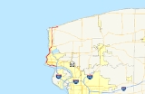
The Robert Moses State Parkway is an 18.42 miles (29.64 km) long north–south highway in western Niagara County, New York
, United States
. Its southern terminus is at the LaSalle Expressway
on the east bank of the Niagara River
in Niagara Falls
. The northern terminus is at NY 18
at Four Mile Creek State Park
in Porter
near Lake Ontario
. Originally, the parkway was one continuous road; however, due to low usage, a portion of the parkway near Niagara Falls
was removed, separating the parkway into two sections. The length of the parkway is designated as New York State Route 957A by the New York State Department of Transportation
. A 1.16 miles (1.87 km) long spur connecting the Robert Moses Parkway to Fort Niagara State Park
near Youngstown
is designated as New York State Route 958A. Both reference route designations are unsigned.
The parkway, a divided highway for most of its route, is one of the most unorthodox parkways in New York State, similar to Ocean Parkway on Long Island
. Some portions, mainly between downtown Niagara Falls and Lewiston
, are not built to freeway standards, and the parkway as a whole has gradually been relegated due to low usage.
in Niagara Falls, New York
. It connects with Interstate 190
and NY 384
just west of its official southern terminus and passes under the North Grand Island Bridge
as it heads west along the Niagara River
. The only interchange along this portion of the route comes 3 miles (5 km) west of I-190, where the parkway connects to a spur leading into Niagara Falls State Park
. The parkway itself turns north here and returns to grade level
at Buffalo Avenue, where the Moses Parkway terminates and continues north as John B. Daly Boulevard (designated but not signed as NY 952B by the New York State Department of Transportation
). One block to the north of this intersection is NY 384, which also comes within one block of the northern portion of the parkway.
 The parkway resumes north of downtown at an intersection with Main Street (NY 104
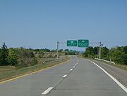
). It heads north as a four-lane divided highway
, passing the northern extents of Niagara Falls State Park and the Aquarium of Niagara as it parallels the Niagara Gorge
. Roughly 0.5 mile (0.80467 km) from NY 104, the parkway downgrades into a two-lane highway. The Robert Moses Parkway continues on, passing over the Whirlpool Rapids Bridge
's eastern approach (and thus NY 182
's western terminus) as it approaches and serves Whirlpool State Park
. North of the park, the highway curves northeastward, matching the curvature of the gorge in the area. After serving the Devil's Hole State Park
and interchanging with NY 104, it passes over the Robert Moses Niagara Power Plant. Many features are within view at this point: to the west of the parkway at this point are the Sir Adam Beck Hydroelectric Power Stations
; to the north are the Lewiston–Queenston Bridge and the Niagara River's course for miles ahead. The parkway interchanges with I-190 via Upper Mountain Road before passing under the bridge and re-widening to four lanes.
Just north of the bridge, the Robert Moses Parkway approaches the edge of the Niagara Escarpment
. Here, it is possible to see for several miles in any direction. Looking north, the remainder of the Niagara River can be seen, as can its mouth at Lake Ontario
. The parkway descends the escarpment and meets NY 18F
and NY 104
just east of the village of Lewiston. North of Lewiston, the Parkway follows a largely north–south routing as it passes through largely rural sections of the towns of Lewiston
and Porter
. During this stretch, it has an exit to Pletcher Road, which links the parkway to Joseph Davis State Park
.
At the village of Youngstown
, the Robert Moses Parkway interchanges with NY 93
. North of the village, the parkway's median widens as it interchanges with a short spur (designated but not signed as NY 958A) leading to Fort Niagara State Park
and Fort Niagara
within. Past this junction, the parkway turns east and begins to parallel Lake Ontario. It passes under NY 18F
and interchanges with Four Mile Creek Drive, the entry road for Four Mile Creek State Park
, before terminating at an at-grade intersection with NY 18
.
with the proposed Niagara Thruway, a spur of the New York State Thruway
, surfaced by the 1950s. The general routing of the highway would begin at the Rainbow Bridge
in downtown and parallel NY 384
on its north side to the North Grand Island Bridge
, where it would turn south to meet the northern terminus of the Niagara Thruway. However, by the 1960s, a new alignment along the bank of the Niagara River
and through the Niagara Falls State Park
was selected instead. Two portions of the "Niagara Parkway", as it was then known, were completed by 1962. The first extended from the Niagara Thruway (Interstate 190
) to the Rainbow Bridge. Another, representing a northward extension of the parkway, was open along the Niagara Gorge
's eastern edge from Niagara Avenue to U.S. Route 104 in Lewiston
. At the time, the sections from the Rainbow Bridge to Niagara Street and US 104 to Ridge Road
in Lewiston were under construction. Both were open to traffic by 1964. An extension of the parkway, now named the "Robert Moses State Parkway" after public works developer Robert Moses
, north to NY 18
in Porter
was completed by 1968. A spur to Fort Niagara
was built as part of the extension.
 The Robert Moses Parkway was to have been part of a vast network of limited-access highways in the Buffalo
area. Under the 1971 Regional Highway Plan for the Buffalo – Niagara Falls area, the parkway would have been paralleled by a westward extension of the LaSalle Expressway
, which would have extended from the Rainbow Bridge to I-190 along the proposed routing shown on maps 20 years before. Farther north, the northern end of the Robert Moses Parkway in Porter would have linked to a western extension of the Lake Ontario State Parkway
. Neither proposal ever came to fruition.
The portion of the Robert Moses Parkway within Niagara Falls State Park was closed and largely removed in the late 1980s as a result of a movement to restore the park to the original layout conceived for it by landscape architect Frederick Law Olmsted
. As a result, the parkway became discontinuous. Its southern segment now began at the pre-existing interchange with Quay Street (John B. Daly Boulevard), which remained virtually untouched, while the southern end of the northern segment was reconfigured in the vicinity of downtown to terminate at an at-grade intersection
with Main Street (NY 104
). Traffic must now employ NY 384 to bridge the two sections of the parkway. The portions of the Robert Moses Parkway that still exist within Niagara Falls State Park are mostly in the vicinity of the Rainbow Bridge and are used for park business only.
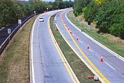
Additional downgrading of the highway has occurred in other areas. From Cedar Street in downtown Niagara Falls to I-190 in Lewiston
, the southbound lanes were gradually converted into a recreation/bike trail during the 2000s, funneling all traffic into the former northbound lanes and turning the parkway into a two-lane highway. Future changes have been proposed for the parkway, which has been referred to as a barrier between the city of Niagara Falls and the riverfront of the Niagara River. One proposed change calls for the replacement of the former Quay Street interchange with a roundabout
, a project which would have cost $12 million to complete in 2006. A second would remove the former routing of the parkway through the southeastern portion of Niagara Falls State Park, which would force all parkway traffic to enter Niagara Falls via John B. Daly Boulevard. There are no set timelines for either project.
|rowspan=7|Niagara Falls
|0.00
| spur
|Eastward continuation of the Robert Moses Parkway
|-
|0.02
|
|Southbound exit and northbound entrance
|-
|
|Niagara Falls State Park
|Northbound exit only
|-
|3.24
|Buffalo Avenue
|At-grade intersection
; roadway continues north as John B. Daly Boulevard (NY 952B)
|-
|colspan=3 align="center"|Gap in parkway
|-
|3.24
|
|At-grade intersection; roadway continues southward as Rainbow Boulevard
|-
|5.04
|Findlay Drive
|At-grade intersection
|-
|rowspan=4|Lewiston
|6.64
|
|Northbound entrance and exit
|-
|7.98
|
|No southbound exit; access via Upper Mountain Road
|-
|9.68
|
|Southern terminus of NY 18F
|-
|12.37
|Pletcher Road – Joseph Davis State Park
|
|-
|rowspan=2|Youngstown
|15.51
|
|
|-
|15.94
|
|Fort Niagara spur
|-
|rowspan=2|Porter
|18.09
|Four Mile Creek State Park
|Northbound exit and southbound entrance
|-
|18.42
|
|At-grade intersection
|0.00
|
|
|-
|
|
|Southbound exit and northbound entrance
|-
|1.16
|Fort Niagara State Park
|
Niagara County, New York
Niagara County is a county located in the U.S. state of New York. As of the 2010 census, the population was 216,469. The county seat is Lockport. The county name is from the Iroquois word Onguiaahra; meaning the strait or thunder of waters. It is the location of Niagara Falls and Fort Niagara, and...
, United States
United States
The United States of America is a federal constitutional republic comprising fifty states and a federal district...
. Its southern terminus is at the LaSalle Expressway
LaSalle Expressway
The LaSalle Expressway is a long limited-access highway in Niagara County, New York, United States. It begins near the North Grand Island Bridge at an interchange with Interstate 190 in Niagara Falls and ends just south of the Niagara Falls International Airport at Williams Road in Wheatfield...
on the east bank of the Niagara River
Niagara River
The Niagara River flows north from Lake Erie to Lake Ontario. It forms part of the border between the Province of Ontario in Canada and New York State in the United States. There are differing theories as to the origin of the name of the river...
in Niagara Falls
Niagara Falls, New York
Niagara Falls is a city in Niagara County, New York, United States. As of the 2010 census, the city had a total population of 50,193, down from the 55,593 recorded in the 2000 census. It is across the Niagara River from Niagara Falls, Ontario , both named after the famed Niagara Falls which they...
. The northern terminus is at NY 18
New York State Route 18
New York State Route 18 is an east–west state highway in western New York in the United States. It runs parallel to the south shore of Lake Ontario for most of its length between Niagara County and Monroe County...
at Four Mile Creek State Park
Four Mile Creek State Park
Four Mile Creek State Park is located in the Town of Porter in Niagara County, New York. The park is at the mouth of Four Mile Creek on the shore of Lake Ontario....
in Porter
Porter, New York
Porter is a town in Niagara County, New York, United States. The population was 6,771 at the 2010 census. The town was named after Judge Augustus Porter....
near Lake Ontario
Lake Ontario
Lake Ontario is one of the five Great Lakes of North America. It is bounded on the north and southwest by the Canadian province of Ontario, and on the south by the American state of New York. Ontario, Canada's most populous province, was named for the lake. In the Wyandot language, ontarío means...
. Originally, the parkway was one continuous road; however, due to low usage, a portion of the parkway near Niagara Falls
Niagara Falls
The Niagara Falls, located on the Niagara River draining Lake Erie into Lake Ontario, is the collective name for the Horseshoe Falls and the adjacent American Falls along with the comparatively small Bridal Veil Falls, which combined form the highest flow rate of any waterfalls in the world and has...
was removed, separating the parkway into two sections. The length of the parkway is designated as New York State Route 957A by the New York State Department of Transportation
New York State Department of Transportation
The New York State Department of Transportation is responsible for the development and operation of highways, railroads, mass transit systems, ports, waterways and aviation facilities in the U.S...
. A 1.16 miles (1.87 km) long spur connecting the Robert Moses Parkway to Fort Niagara State Park
Fort Niagara State Park
Fort Niagara State Park is located in the Town of Porter in Niagara County, New York, USA. Historic Fort Niagara is located within the park. The park is northwest of Youngstown, New York near the northern terminus of the Robert Moses State Parkway....
near Youngstown
Youngstown, New York
Youngstown is a village in Niagara County, New York, USA. The population was 1,957 at the 2000 census. It is part of the Buffalo–Niagara Falls Metropolitan Statistical Area....
is designated as New York State Route 958A. Both reference route designations are unsigned.
The parkway, a divided highway for most of its route, is one of the most unorthodox parkways in New York State, similar to Ocean Parkway on Long Island
Long Island
Long Island is an island located in the southeast part of the U.S. state of New York, just east of Manhattan. Stretching northeast into the Atlantic Ocean, Long Island contains four counties, two of which are boroughs of New York City , and two of which are mainly suburban...
. Some portions, mainly between downtown Niagara Falls and Lewiston
Lewiston (town), New York
Lewiston is a town in Niagara County, New York United States. The population was 16,262 at the 2010 census. The town and its contained village are named after Morgan Lewis, a governor of New York....
, are not built to freeway standards, and the parkway as a whole has gradually been relegated due to low usage.
Route description
The Robert Moses State Parkway begins as a westward continuation of a spur off the LaSalle ExpresswayLaSalle Expressway
The LaSalle Expressway is a long limited-access highway in Niagara County, New York, United States. It begins near the North Grand Island Bridge at an interchange with Interstate 190 in Niagara Falls and ends just south of the Niagara Falls International Airport at Williams Road in Wheatfield...
in Niagara Falls, New York
Niagara Falls, New York
Niagara Falls is a city in Niagara County, New York, United States. As of the 2010 census, the city had a total population of 50,193, down from the 55,593 recorded in the 2000 census. It is across the Niagara River from Niagara Falls, Ontario , both named after the famed Niagara Falls which they...
. It connects with Interstate 190
Interstate 190 (New York)
Interstate 190 runs 28.34 miles from Interstate 90 near Buffalo, New York to Lewiston, New York via Niagara Falls. Parts of this highway were built on the former rights-of-way of the Lehigh Valley Railroad and the Erie Canal. It is referred to by locals as The One-Ninety...
and NY 384
New York State Route 384
New York State Route 384 is a state highway in Western New York in the United States. It is a north–south route extending from the city of Buffalo, Erie County to the city of Niagara Falls, Niagara County, and is one of several routes directly connecting the two cities. The southern terminus...
just west of its official southern terminus and passes under the North Grand Island Bridge
North Grand Island Bridge
The North Grand Island Bridge carries Interstate 190 across the Niagara River between Grand Island, New York and Niagara Falls, New York. The toll plaza are found on the Grand Island, New York side of the bridge....
as it heads west along the Niagara River
Niagara River
The Niagara River flows north from Lake Erie to Lake Ontario. It forms part of the border between the Province of Ontario in Canada and New York State in the United States. There are differing theories as to the origin of the name of the river...
. The only interchange along this portion of the route comes 3 miles (5 km) west of I-190, where the parkway connects to a spur leading into Niagara Falls State Park
Niagara Falls State Park
Niagara Falls State Park is located in the City of Niagara Falls, New York in Niagara County. The park has the American Falls, the Bridal Veil Falls, and part of the Canadian Falls....
. The parkway itself turns north here and returns to grade level
At-grade intersection
An at-grade intersection is a junction at which two or more transport axes cross at the same level .-Traffic management:With areas of high or fast traffic, an at-grade intersection normally requires a traffic control device such as a stop sign, traffic light or railway signal to manage conflicting...
at Buffalo Avenue, where the Moses Parkway terminates and continues north as John B. Daly Boulevard (designated but not signed as NY 952B by the New York State Department of Transportation
New York State Department of Transportation
The New York State Department of Transportation is responsible for the development and operation of highways, railroads, mass transit systems, ports, waterways and aviation facilities in the U.S...
). One block to the north of this intersection is NY 384, which also comes within one block of the northern portion of the parkway.
New York State Route 104
New York State Route 104 is a long east–west state highway in Upstate New York, United States. It spans six counties and enters the vicinity of four cities—Niagara Falls, Lockport, Rochester, and Oswego—as it follows a routing largely parallel to that of the southern shoreline of Lake...
). It heads north as a four-lane divided highway
Divided Highway
Divided Highway is a compilation album by American rock band The Doobie Brothers, released in 2003. . All tracks are taken from the albums Cycles and Brotherhood .-Track listing:...
, passing the northern extents of Niagara Falls State Park and the Aquarium of Niagara as it parallels the Niagara Gorge
Niagara Gorge
Niagara Gorge is a gorge carved by the Niagara River along the US-Canadian border in New York and Ontario. As Niagara Falls recedes upstream toward Lake Erie, the river has gouged the hard dolomitic limestone of the Niagara escarpment to form the gorge...
. Roughly 0.5 mile (0.80467 km) from NY 104, the parkway downgrades into a two-lane highway. The Robert Moses Parkway continues on, passing over the Whirlpool Rapids Bridge
Whirlpool Rapids Bridge
The Whirlpool Rapids Bridge, commonly called the Whirlpool Bridge, and until 1937, known as the Lower Steel Arch Bridge, is a spandrel braced, riveted, two-hinged arch bridge. It crosses the international border between Canada and the United States, connecting the commercial downtown districts of...
's eastern approach (and thus NY 182
New York State Route 182
New York State Route 182 is a state highway in Niagara County, New York, United States. It serves as a signed connection between the Whirlpool Rapids Bridge over the Niagara River and the Niagara Falls International Airport east of the city of Niagara Falls...
's western terminus) as it approaches and serves Whirlpool State Park
Whirlpool State Park
Whirlpool State Park is located in Niagara County, New York, north of the city of Niagara Falls. The park overlooks the Niagara Whirlpool on the Niagara River and the lower Niagara Gorge....
. North of the park, the highway curves northeastward, matching the curvature of the gorge in the area. After serving the Devil's Hole State Park
Devil's Hole State Park
Devil's Hole State Park is located in Niagara County, New York north of the City of Niagara Falls. The park overlooks the Niagara River Gorge.The park offers fishing, hiking, nature trail, picnic tables, snow-shoe trails, and cross-country skiing....
and interchanging with NY 104, it passes over the Robert Moses Niagara Power Plant. Many features are within view at this point: to the west of the parkway at this point are the Sir Adam Beck Hydroelectric Power Stations
Sir Adam Beck Hydroelectric Power Stations
Sir Adam Beck Hydroelectric Power Stations are two hydroelectric power stations in Niagara Falls, Ontario, Canada. The stations divert water from the Niagara and Welland Rivers above the falls which is then released into the lower portion of the river, and together produce up to 1,926 MW.Adam Beck...
; to the north are the Lewiston–Queenston Bridge and the Niagara River's course for miles ahead. The parkway interchanges with I-190 via Upper Mountain Road before passing under the bridge and re-widening to four lanes.
Just north of the bridge, the Robert Moses Parkway approaches the edge of the Niagara Escarpment
Niagara Escarpment
The Niagara Escarpment is a long escarpment, or cuesta, in the United States and Canada that runs westward from New York State, through Ontario, Michigan, Wisconsin and Illinois...
. Here, it is possible to see for several miles in any direction. Looking north, the remainder of the Niagara River can be seen, as can its mouth at Lake Ontario
Lake Ontario
Lake Ontario is one of the five Great Lakes of North America. It is bounded on the north and southwest by the Canadian province of Ontario, and on the south by the American state of New York. Ontario, Canada's most populous province, was named for the lake. In the Wyandot language, ontarío means...
. The parkway descends the escarpment and meets NY 18F
New York State Route 18F
New York State Route 18F is a long state highway in northwestern Niagara County, New York, United States. The southern terminus of the route is at an interchange with NY 104 and the Robert Moses State Parkway just east of the village of Lewiston. The northern terminus is at an...
and NY 104
New York State Route 104
New York State Route 104 is a long east–west state highway in Upstate New York, United States. It spans six counties and enters the vicinity of four cities—Niagara Falls, Lockport, Rochester, and Oswego—as it follows a routing largely parallel to that of the southern shoreline of Lake...
just east of the village of Lewiston. North of Lewiston, the Parkway follows a largely north–south routing as it passes through largely rural sections of the towns of Lewiston
Lewiston (town), New York
Lewiston is a town in Niagara County, New York United States. The population was 16,262 at the 2010 census. The town and its contained village are named after Morgan Lewis, a governor of New York....
and Porter
Porter, New York
Porter is a town in Niagara County, New York, United States. The population was 6,771 at the 2010 census. The town was named after Judge Augustus Porter....
. During this stretch, it has an exit to Pletcher Road, which links the parkway to Joseph Davis State Park
Joseph Davis State Park
Joseph Davis State Park is located in the Town of Porter in Niagara County, New York. The park is near the Niagara River. This park has a free 27-hole disc golf course with restrooms and campground nearby. It has a finishing point of The Amazing Race: Family Edition when the Linz family had...
.
At the village of Youngstown
Youngstown, New York
Youngstown is a village in Niagara County, New York, USA. The population was 1,957 at the 2000 census. It is part of the Buffalo–Niagara Falls Metropolitan Statistical Area....
, the Robert Moses Parkway interchanges with NY 93
New York State Route 93
New York State Route 93 is a state highway in western New York in the United States. It runs in a northwest–southeast direction between NY 18F near the Niagara River in the village of Youngstown and NY 5 just south of the village of Akron...
. North of the village, the parkway's median widens as it interchanges with a short spur (designated but not signed as NY 958A) leading to Fort Niagara State Park
Fort Niagara State Park
Fort Niagara State Park is located in the Town of Porter in Niagara County, New York, USA. Historic Fort Niagara is located within the park. The park is northwest of Youngstown, New York near the northern terminus of the Robert Moses State Parkway....
and Fort Niagara
Fort Niagara
Fort Niagara is a fortification originally built to protect the interests of New France in North America. It is located near Youngstown, New York, on the eastern bank of the Niagara River at its mouth, on Lake Ontario.-Origin:...
within. Past this junction, the parkway turns east and begins to parallel Lake Ontario. It passes under NY 18F
New York State Route 18F
New York State Route 18F is a long state highway in northwestern Niagara County, New York, United States. The southern terminus of the route is at an interchange with NY 104 and the Robert Moses State Parkway just east of the village of Lewiston. The northern terminus is at an...
and interchanges with Four Mile Creek Drive, the entry road for Four Mile Creek State Park
Four Mile Creek State Park
Four Mile Creek State Park is located in the Town of Porter in Niagara County, New York. The park is at the mouth of Four Mile Creek on the shore of Lake Ontario....
, before terminating at an at-grade intersection with NY 18
New York State Route 18
New York State Route 18 is an east–west state highway in western New York in the United States. It runs parallel to the south shore of Lake Ontario for most of its length between Niagara County and Monroe County...
.
History
Proposals for a limited-access highway to connect downtown Niagara FallsNiagara Falls, New York
Niagara Falls is a city in Niagara County, New York, United States. As of the 2010 census, the city had a total population of 50,193, down from the 55,593 recorded in the 2000 census. It is across the Niagara River from Niagara Falls, Ontario , both named after the famed Niagara Falls which they...
with the proposed Niagara Thruway, a spur of the New York State Thruway
New York State Thruway
The New York State Thruway is a system of limited-access highways located within the state of New York in the United States. The system, known officially as the Governor Thomas E. Dewey Thruway for former New York Governor Thomas E. Dewey, is operated by the New York State Thruway Authority and...
, surfaced by the 1950s. The general routing of the highway would begin at the Rainbow Bridge
Rainbow Bridge (Niagara Falls)
The Rainbow Bridge at Niagara Falls is an international steel arch bridge across the Niagara River gorge, and is a world-famous tourist site. It connects the cities of Niagara Falls, New York, United States , and Niagara Falls, Ontario, Canada .-Construction:The Rainbow Bridge was built near the...
in downtown and parallel NY 384
New York State Route 384
New York State Route 384 is a state highway in Western New York in the United States. It is a north–south route extending from the city of Buffalo, Erie County to the city of Niagara Falls, Niagara County, and is one of several routes directly connecting the two cities. The southern terminus...
on its north side to the North Grand Island Bridge
North Grand Island Bridge
The North Grand Island Bridge carries Interstate 190 across the Niagara River between Grand Island, New York and Niagara Falls, New York. The toll plaza are found on the Grand Island, New York side of the bridge....
, where it would turn south to meet the northern terminus of the Niagara Thruway. However, by the 1960s, a new alignment along the bank of the Niagara River
Niagara River
The Niagara River flows north from Lake Erie to Lake Ontario. It forms part of the border between the Province of Ontario in Canada and New York State in the United States. There are differing theories as to the origin of the name of the river...
and through the Niagara Falls State Park
Niagara Falls State Park
Niagara Falls State Park is located in the City of Niagara Falls, New York in Niagara County. The park has the American Falls, the Bridal Veil Falls, and part of the Canadian Falls....
was selected instead. Two portions of the "Niagara Parkway", as it was then known, were completed by 1962. The first extended from the Niagara Thruway (Interstate 190
Interstate 190 (New York)
Interstate 190 runs 28.34 miles from Interstate 90 near Buffalo, New York to Lewiston, New York via Niagara Falls. Parts of this highway were built on the former rights-of-way of the Lehigh Valley Railroad and the Erie Canal. It is referred to by locals as The One-Ninety...
) to the Rainbow Bridge. Another, representing a northward extension of the parkway, was open along the Niagara Gorge
Niagara Gorge
Niagara Gorge is a gorge carved by the Niagara River along the US-Canadian border in New York and Ontario. As Niagara Falls recedes upstream toward Lake Erie, the river has gouged the hard dolomitic limestone of the Niagara escarpment to form the gorge...
's eastern edge from Niagara Avenue to U.S. Route 104 in Lewiston
Lewiston (town), New York
Lewiston is a town in Niagara County, New York United States. The population was 16,262 at the 2010 census. The town and its contained village are named after Morgan Lewis, a governor of New York....
. At the time, the sections from the Rainbow Bridge to Niagara Street and US 104 to Ridge Road
Ridge Road (Western New York)
Ridge Road is a east–west road that traverses four counties in Upstate New York in the United States. It is named for the rise atop which the road was built, a mound of sand and gravel that was formed when it was the shoreline of ancient Glacial Lake Iroquois...
in Lewiston were under construction. Both were open to traffic by 1964. An extension of the parkway, now named the "Robert Moses State Parkway" after public works developer Robert Moses
Robert Moses
Robert Moses was the "master builder" of mid-20th century New York City, Long Island, Rockland County, and Westchester County, New York. As the shaper of a modern city, he is sometimes compared to Baron Haussmann of Second Empire Paris, and is one of the most polarizing figures in the history of...
, north to NY 18
New York State Route 18
New York State Route 18 is an east–west state highway in western New York in the United States. It runs parallel to the south shore of Lake Ontario for most of its length between Niagara County and Monroe County...
in Porter
Porter, New York
Porter is a town in Niagara County, New York, United States. The population was 6,771 at the 2010 census. The town was named after Judge Augustus Porter....
was completed by 1968. A spur to Fort Niagara
Fort Niagara
Fort Niagara is a fortification originally built to protect the interests of New France in North America. It is located near Youngstown, New York, on the eastern bank of the Niagara River at its mouth, on Lake Ontario.-Origin:...
was built as part of the extension.
Buffalo, New York
Buffalo is the second most populous city in the state of New York, after New York City. Located in Western New York on the eastern shores of Lake Erie and at the head of the Niagara River across from Fort Erie, Ontario, Buffalo is the seat of Erie County and the principal city of the...
area. Under the 1971 Regional Highway Plan for the Buffalo – Niagara Falls area, the parkway would have been paralleled by a westward extension of the LaSalle Expressway
LaSalle Expressway
The LaSalle Expressway is a long limited-access highway in Niagara County, New York, United States. It begins near the North Grand Island Bridge at an interchange with Interstate 190 in Niagara Falls and ends just south of the Niagara Falls International Airport at Williams Road in Wheatfield...
, which would have extended from the Rainbow Bridge to I-190 along the proposed routing shown on maps 20 years before. Farther north, the northern end of the Robert Moses Parkway in Porter would have linked to a western extension of the Lake Ontario State Parkway
Lake Ontario State Parkway
The Lake Ontario State Parkway is a parkway along the southern shore of Lake Ontario in western New York in the United States. The western end of the highway is at a partial interchange within Lakeside Beach State Park in Carlton, Orleans County. Its eastern terminus is at an intersection with...
. Neither proposal ever came to fruition.
The portion of the Robert Moses Parkway within Niagara Falls State Park was closed and largely removed in the late 1980s as a result of a movement to restore the park to the original layout conceived for it by landscape architect Frederick Law Olmsted
Frederick Law Olmsted
Frederick Law Olmsted was an American journalist, social critic, public administrator, and landscape designer. He is popularly considered to be the father of American landscape architecture, although many scholars have bestowed that title upon Andrew Jackson Downing...
. As a result, the parkway became discontinuous. Its southern segment now began at the pre-existing interchange with Quay Street (John B. Daly Boulevard), which remained virtually untouched, while the southern end of the northern segment was reconfigured in the vicinity of downtown to terminate at an at-grade intersection
At-grade intersection
An at-grade intersection is a junction at which two or more transport axes cross at the same level .-Traffic management:With areas of high or fast traffic, an at-grade intersection normally requires a traffic control device such as a stop sign, traffic light or railway signal to manage conflicting...
with Main Street (NY 104
New York State Route 104
New York State Route 104 is a long east–west state highway in Upstate New York, United States. It spans six counties and enters the vicinity of four cities—Niagara Falls, Lockport, Rochester, and Oswego—as it follows a routing largely parallel to that of the southern shoreline of Lake...
). Traffic must now employ NY 384 to bridge the two sections of the parkway. The portions of the Robert Moses Parkway that still exist within Niagara Falls State Park are mostly in the vicinity of the Rainbow Bridge and are used for park business only.
Additional downgrading of the highway has occurred in other areas. From Cedar Street in downtown Niagara Falls to I-190 in Lewiston
Lewiston (town), New York
Lewiston is a town in Niagara County, New York United States. The population was 16,262 at the 2010 census. The town and its contained village are named after Morgan Lewis, a governor of New York....
, the southbound lanes were gradually converted into a recreation/bike trail during the 2000s, funneling all traffic into the former northbound lanes and turning the parkway into a two-lane highway. Future changes have been proposed for the parkway, which has been referred to as a barrier between the city of Niagara Falls and the riverfront of the Niagara River. One proposed change calls for the replacement of the former Quay Street interchange with a roundabout
Roundabout
A roundabout is the name for a road junction in which traffic moves in one direction around a central island. The word dates from the early 20th century. Roundabouts are common in many countries around the world...
, a project which would have cost $12 million to complete in 2006. A second would remove the former routing of the parkway through the southeastern portion of Niagara Falls State Park, which would force all parkway traffic to enter Niagara Falls via John B. Daly Boulevard. There are no set timelines for either project.
Exit list
|-|rowspan=7|Niagara Falls
Niagara Falls, New York
Niagara Falls is a city in Niagara County, New York, United States. As of the 2010 census, the city had a total population of 50,193, down from the 55,593 recorded in the 2000 census. It is across the Niagara River from Niagara Falls, Ontario , both named after the famed Niagara Falls which they...
|0.00
| spur
|Eastward continuation of the Robert Moses Parkway
|-
|0.02
|
|Southbound exit and northbound entrance
|-
|
|Niagara Falls State Park
Niagara Falls State Park
Niagara Falls State Park is located in the City of Niagara Falls, New York in Niagara County. The park has the American Falls, the Bridal Veil Falls, and part of the Canadian Falls....
|Northbound exit only
|-
|3.24
|Buffalo Avenue
|At-grade intersection
At-grade intersection
An at-grade intersection is a junction at which two or more transport axes cross at the same level .-Traffic management:With areas of high or fast traffic, an at-grade intersection normally requires a traffic control device such as a stop sign, traffic light or railway signal to manage conflicting...
; roadway continues north as John B. Daly Boulevard (NY 952B)
|-
|colspan=3 align="center"|Gap in parkway
|-
|3.24
|
|At-grade intersection; roadway continues southward as Rainbow Boulevard
|-
|5.04
|Findlay Drive
|At-grade intersection
|-
|rowspan=4|Lewiston
Lewiston (town), New York
Lewiston is a town in Niagara County, New York United States. The population was 16,262 at the 2010 census. The town and its contained village are named after Morgan Lewis, a governor of New York....
|6.64
|
|Northbound entrance and exit
|-
|7.98
|
|No southbound exit; access via Upper Mountain Road
|-
|9.68
|
|Southern terminus of NY 18F
|-
|12.37
|Pletcher Road – Joseph Davis State Park
Joseph Davis State Park
Joseph Davis State Park is located in the Town of Porter in Niagara County, New York. The park is near the Niagara River. This park has a free 27-hole disc golf course with restrooms and campground nearby. It has a finishing point of The Amazing Race: Family Edition when the Linz family had...
|
|-
|rowspan=2|Youngstown
Youngstown, New York
Youngstown is a village in Niagara County, New York, USA. The population was 1,957 at the 2000 census. It is part of the Buffalo–Niagara Falls Metropolitan Statistical Area....
|15.51
|
|
|-
|15.94
|
|Fort Niagara spur
|-
|rowspan=2|Porter
Porter, New York
Porter is a town in Niagara County, New York, United States. The population was 6,771 at the 2010 census. The town was named after Judge Augustus Porter....
|18.09
|Four Mile Creek State Park
Four Mile Creek State Park
Four Mile Creek State Park is located in the Town of Porter in Niagara County, New York. The park is at the mouth of Four Mile Creek on the shore of Lake Ontario....
|Northbound exit and southbound entrance
|-
|18.42
|
|At-grade intersection
Fort Niagara spur
|-|0.00
|
|
|-
|
|
|Southbound exit and northbound entrance
|-
|1.16
|Fort Niagara State Park
Fort Niagara State Park
Fort Niagara State Park is located in the Town of Porter in Niagara County, New York, USA. Historic Fort Niagara is located within the park. The park is northwest of Youngstown, New York near the northern terminus of the Robert Moses State Parkway....
|
See also
- Niagara ParkwayNiagara ParkwayThe Niagara Parkway, formerly known as Niagara Boulevard and historically as the Niagara Road, is a scenic road in the province of Ontario that travels on the Canadian side of the Niagara River from the town of Fort Erie to Niagara-on-the-Lake...
, the counterpart to the Robert Moses State Parkway on the Canadian side of the Niagara RiverNiagara RiverThe Niagara River flows north from Lake Erie to Lake Ontario. It forms part of the border between the Province of Ontario in Canada and New York State in the United States. There are differing theories as to the origin of the name of the river...