
Nevada State Route 208
Encyclopedia
State highway
State highway, state road or state route can refer to one of three related concepts, two of them related to a state or provincial government in a country that is divided into states or provinces :#A...
within the counties of Douglas
Douglas County, Nevada
Douglas County is a county located in the northwestern part of the U.S. state of Nevada. As of 2000, the population was 41,259. As of 2010, the population was estimated to be 46,997.- History :...
and Lyon
Lyon County, Nevada
Lyon County is a county located in the U.S. state of Nevada. As of the 2010 census, the population was 51,980. Its county seat is Yerington.-History:...
in Nevada
Nevada
Nevada is a state in the western, mountain west, and southwestern regions of the United States. With an area of and a population of about 2.7 million, it is the 7th-largest and 35th-most populous state. Over two-thirds of Nevada's people live in the Las Vegas metropolitan area, which contains its...
, USA. It connects U.S. Route 395
U.S. Route 395 in Nevada
In the U.S. state of Nevada, U.S. Route 395 clips a corner of Nevada near Lake Tahoe and serves the cities of Gardnerville, Minden, Carson City and Reno. Most of US 395 north of Carson City is a freeway and is built up to Interstate standards. Part of the freeway section is also currently...
(US 395) north of Topaz Lake
Topaz Lake
Topaz Lake is a reservoir located on the California-Nevada border, about south of Reno.The lake was formed by diverting waters from the West Walker River into a nearby basin that had previously contained a smaller, natural lake. The initial construction took place in 1922, resulting in a...
to Alternate U.S. Route 95 in Yerington
Yerington, Nevada
Yerington is a city in Lyon County, located in western Nevada, USA. The population was 2,883 at the 2000 census. It is named after Henry M. Yerington, Superintendent of the Virginia and Truckee Railroad from 1868 to 1910. It is the county seat of Lyon County....
. The road serves as the primary transportation corridor of Smith Valley
Smith Valley, Nevada
Smith Valley is a census-designated place in Lyon County, Nevada, United States. The population was 1,425 at the 2000 census.-Geography:Smith Valley is located at ....
and is Main street in Yerington. The route was originally a portion of State Route 3
Nevada State Route 3
State Route 3 was the original designation for SR 208, SR 266 and SR 429. It was also the original designation for sections of SR 430, US 50, US 95, Alternate US 95, and US 395....
.
Route description
The character of the highway gradually changes descending from the foothills of the Sierra Nevada into high desert, finally reaching the agricultural communities of SmithSmith Valley, Nevada
Smith Valley is a census-designated place in Lyon County, Nevada, United States. The population was 1,425 at the 2000 census.-Geography:Smith Valley is located at ....
and Mason Valley
Mason Valley
The Mason Valley is a valley in western Nevada, between the Singatse Range and the Wassuk Range.The Walker River flows through the valley from south to north. The city of Yerington is located in the center of the valley. The Pine Nut Mountains are nearby....
s. The highway begins at a junction with US 395 in the foothills of the Sierra Nevada, at a junction called Holbrook Junction.
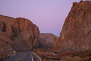
The highway descends out of the Sierra into Smith Valley. Once reaching the valley the road joins the route of the West Walker River
West Walker River
The West Walker River is a tributary of the Walker River, approximately long, in eastern California and western Nevada in the United States. It drains part of the Sierra Nevada range along the California-Nevada border in the watershed of Walker Lake in the Great Basin.It rises from snowmelt in the...
, which the highway follows from this point on. The highway departs Smith Valley via the river, using Wilson Canyon to connect with Mason Valley, another agricultural valley in the otherwise arid deserts of Nevada.
Inside Mason Valley the road forks, with route 208 serving the east side of the valley and route 339 serving the west. Shortly after the split is where the West and East Walker River
East Walker River
The East Walker River is a tributary of the Walker River, approximately long, in eastern California and western Nevada in the United States. It drains part of the eastern side of the Sierra Nevada in the watershed of Walker Lake in the Great Basin....
s merge to form the Walker River. Both roads lead to Yerington
Yerington, Nevada
Yerington is a city in Lyon County, located in western Nevada, USA. The population was 2,883 at the 2000 census. It is named after Henry M. Yerington, Superintendent of the Virginia and Truckee Railroad from 1868 to 1910. It is the county seat of Lyon County....
, straddling each side of the river. In Yerington, Route 208 serves as Main Street. The route terminates at the north end of Yerington where traffic defaults onto southbound U.S. Route 95 Alternate.
History
This is one of the oldest highways in Nevada. The route was first part of the lesser used Sonora PassSonora Pass
Sonora Pass is the second-highest highway pass in the Sierra Nevada, lower by 321 ft. than Tioga Pass to the south. State Route 108 traverses the pass.-Description:...
branch of the California Trail
California Trail
The California Trail was an emigrant trail of about across the western half of the North American continent from Missouri River towns to what is now the state of California...
. The route appeared as a highway on maps since at least as far back as 1919. The highway was first numbered as a portion of State Route 3, a designation in use by 1929. The State Route 3 designation extended from Reno
Reno, Nevada
Reno is the county seat of Washoe County, Nevada, United States. The city has a population of about 220,500 and is the most populous Nevada city outside of the Las Vegas metropolitan area...
to the California
California
California is a state located on the West Coast of the United States. It is by far the most populous U.S. state, and the third-largest by land area...
state line in Fish Lake Valley
Fish Lake Valley
The Fish Lake Valley is a 25 mi long endorheic valley in southwest Nevada that is one of the Central Nevada Desert Basins. The alluvial valley lies just northwest of Death Valley and borders the southeast, and central-northeast flank of the massif of the White Mountains of California...
west of Lida
Lida, Nevada
Lida, Nevada is a small town in Esmeralda County, Nevada, near the border with California. It is located on State Route 266, north of Magruder Mountain....
. This route is drivable today as State Routes 430
Nevada State Route 430
State Route 430 is a major north–south state highway in Washoe County, Nevada which currently exists as two separate sections. South of Reno, the route follows the Carson-Reno Highway, and currently overlaps U.S. Route 395. In Reno, the highway follows Virginia Street, the primary...
, 429
Nevada State Route 429
State Route 429 is a rural state highway located in southern Washoe County, Nevada. It is named Bowers Mansion Road and is a former alignment of U.S. Route 395 .-Route description:...
, 529
Nevada State Route 529
State Route 529 is a state highway in Carson City, Nevada, USA. The route follows Carson Street, the principal north–south arterial through the city. The southern portion of the unsigned highway currently carries U.S. Route 50 and U.S. Route 395 through the city, while the remainder of the...
and U.S. Route 395 to the modern terminus of Route 208. It extended past Yerington via what is now U.S. Route 95 Alternate, U.S. Route 95 and SR 266
Nevada State Route 266
State Route 266 is a state highway in Esmeralda County, Nevada, USA. It connects the routing of California State Route 266 east to U.S. Route 95 via the town of Lida...
.
During the late 1970s and early 1980s the state of Nevada renumbered most state routes. The 1978 edition of the Nevada Highways map was the first to use both the 3 and 208 designations, with the 1982 edition the first to use only the 208 designation.
Major intersections
- Note: Mileposts in Nevada reset at county lines; the start and end mileposts for each county are given in the county column.