
Nevada State Route 430
Encyclopedia
State Route 430 is a major north–south state highway
in Washoe County
, Nevada
which currently exists as two separate sections. South of Reno
, the route follows the Carson-Reno Highway, and currently overlaps U.S. Route 395. In Reno, the highway follows Virginia Street, the primary north–south arterial street of the city. SR 430, as well as the gap between the two segments, is also designated as U.S. Route 395 Business within Reno city limits, although the business route is mostly unsigned.
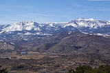
From its southern terminus, the route curves northeast through Washoe City. As the highway exits the town, it briefly climbs southeast of Washoe Hill to ascends Washoe Summit (elevation 5089 feet (1,551.1 m)). The junction with Eastlake Boulevard (former SR 428) at the top of this hill is dubbed the "Washoe Hill Memorial", and is dedicated to victims of drunk driving. As the road descends, it curves north once again to enter Pleasant Valley
. The route crosses over Steamboat Creek and Jones Creek as it passes through the rural community.
 After leaving Pleasant Valley, SR 430 curves east and north again to travel through Steamboat Hills. Development of this small community dates back to 1859, when a small resort was established that took advantage of the natural hot springs
nearby. Steamboat's springs
are still active today, producing geothermal power
for northwest Nevada since 1991.
The highway meets the Mount Rose Junction just north of Steamboat. This junction provides access to Mount Rose
and North Lake Tahoe
via Mount Rose Highway (State Route 431), as well as Virginia City
to the southeast by Geiger Grade (State Route 341). After passing the junction, the route enters the Reno city limits. US 395 departs from SR 430 shortly thereafter, following the North–South Freeway into Reno.
Beyond SR 430's terminus, businesses appear more frequently along the arterial. Large retail stores, shopping malls and restaurants begin to line the sides of the business route. After passing another interchange with US 395 (also unsigned Interstate 580
by this point) and the junction with Kietzke Lane, the Reno-Sparks Convention Center can be seen along the east side of the road, along with larger casino
properties and additional businesses as the route continues north. Passing north of California Avenue, Virginia Street narrows down and reaches Downtown Reno. Seen amongst other businesses along the highway are major office buildings, government institutions, and cultural centers.
In the center of Reno, Business US 395 crosses over the Truckee River
on the Virginia Street Bridge
. The river crossing dates back to 1860, prior to the Reno's existence as "Lake's Crossing". The current structure, built in 1905 as the fifth bridge at this location, is the oldest bridge in Reno and was one of the first reinforced concrete bridges built in Nevada. Designed by John B. Leonard
, the structure includes etchings to resemble masonry. Since 1992, the bridge structure has been declared structurally deficient due to its impedance of high water flows on the Truckee. Balancing the structure's historic status
with the required flood water flow conveyance has stalled rehabilitation or replacement of the structure.
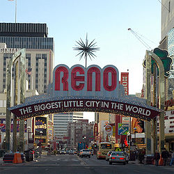 On the opposite side of the river crossing, US 395 Business reaches enters downtown core. Each side of the highway is lined with numerous casinos and small businesses. Portions of Virginia Street between First Street and Sixth Street are frequently closed to vehicular traffic (most often in the summertime) to host special events that attract tourists and locals to the downtown area; such events include Hot August Nights, Street Vibrations, parades, and other activities. A notable landmark along this stretch of roadway is the Biggest Little City in the World sign
. Located at Virginia and Commercial Row (just south of Third Street), the current version of this famous arch was erected in 1987.
North of downtown, the route intersects Interstate 80 as it heads away from the casinos. Just past the Interstate, Business US 395 encounters the University of Nevada, Reno
campus. Academic buildings, residence halls, the student union, Lawlor Events Center
and Fleischmann Planetarium are university buildings visible from Virginia Street, which follows the western border of the campus.
State Route 430's northern segment begins as Virginia Street crosses North McCarran Boulevard (State Route 659). Roadside businesses taper off as the route travels north out of Reno, paralleling Union Pacific railroad tracks heading towards northern California. Both SR 430 and US 395 Business terminate at the route's final interchange with US 395 near Panther Valley north of Reno.
In 2001, the gap between the two segments of SR 430 along Virginia Street was much smaller. The southern section had a northern terminus at the intersection with Plumb Lane (SR 653
). However, the state maintained part of South Virginia Street was truncated to the I-580
half interchange by 2006. More of SR 430 was given to local control by 2008, when the northern terminus of the southern section was moved to Patriot Boulevard. Also in 2001, the northern segment of SR 430 had a southern terminus at I-80
. However, the portion of North Virginia Street along the west edge of the University of Nevada, Reno between I-80 and North McCarran Boulevard (SR 659) was relinquished to the City of Reno by January 2008.
.
State highway
State highway, state road or state route can refer to one of three related concepts, two of them related to a state or provincial government in a country that is divided into states or provinces :#A...
in Washoe County
Washoe County, Nevada
Washoe County is a county located in the U.S. state of Nevada. The population was 421,407 at the 2010 census. Its county seat is Reno. Washoe County includes the Reno-Sparks metropolitan area.-History:...
, Nevada
Nevada
Nevada is a state in the western, mountain west, and southwestern regions of the United States. With an area of and a population of about 2.7 million, it is the 7th-largest and 35th-most populous state. Over two-thirds of Nevada's people live in the Las Vegas metropolitan area, which contains its...
which currently exists as two separate sections. South of Reno
Reno, Nevada
Reno is the county seat of Washoe County, Nevada, United States. The city has a population of about 220,500 and is the most populous Nevada city outside of the Las Vegas metropolitan area...
, the route follows the Carson-Reno Highway, and currently overlaps U.S. Route 395. In Reno, the highway follows Virginia Street, the primary north–south arterial street of the city. SR 430, as well as the gap between the two segments, is also designated as U.S. Route 395 Business within Reno city limits, although the business route is mostly unsigned.
Carson-Reno Highway
State Route 430 begins near Winters Ranch just south of the small town of Washoe City at its junction with U.S. Route 395 and Bowers Mansion Road (State Route 429). At this point, the route is concurrent with US 395 as it makes it way towards Reno.From its southern terminus, the route curves northeast through Washoe City. As the highway exits the town, it briefly climbs southeast of Washoe Hill to ascends Washoe Summit (elevation 5089 feet (1,551.1 m)). The junction with Eastlake Boulevard (former SR 428) at the top of this hill is dubbed the "Washoe Hill Memorial", and is dedicated to victims of drunk driving. As the road descends, it curves north once again to enter Pleasant Valley
Pleasant Valley, Nevada
Pleasant Valley is a very small, unincorporated community in Washoe County, Nevada, United States. The ZIP Code for Pleasant Valley is 89511. The community is part of the Reno–Sparks Metropolitan Statistical Area, and US Route 395 runs through it, and acts as a divider between the eastern and...
. The route crosses over Steamboat Creek and Jones Creek as it passes through the rural community.
Hot Springs
Hot Springs may refer to:* Hot Springs, Arkansas** Hot Springs National Park, Arkansas*Hot Springs, California**Hot Springs, Lassen County, California**Hot Springs, Modoc County, California**Hot Springs, Placer County, California...
nearby. Steamboat's springs
Steamboat Springs, Nevada
Steamboat Springs is a small volcanic field of rhyolitic lava domes and flows in western Nevada, USA, located south of Reno. There is extensive geothermal activity in the area, including numerous hot springs, steam vents, and fumaroles...
are still active today, producing geothermal power
Geothermal power
Geothermal energy is thermal energy generated and stored in the Earth. Thermal energy is the energy that determines the temperature of matter. Earth's geothermal energy originates from the original formation of the planet and from radioactive decay of minerals...
for northwest Nevada since 1991.
The highway meets the Mount Rose Junction just north of Steamboat. This junction provides access to Mount Rose
Mount Rose (Washoe County, Nevada)
Mount Rose is a mountain located in the Carson Range east of the California-Nevada border and is within the Mount Rose Wilderness. An extinct volcano, the mountain is located between Lake Tahoe and Reno;...
and North Lake Tahoe
Lake Tahoe
Lake Tahoe is a large freshwater lake in the Sierra Nevada of the United States. At a surface elevation of , it is located along the border between California and Nevada, west of Carson City. Lake Tahoe is the largest alpine lake in North America. Its depth is , making it the USA's second-deepest...
via Mount Rose Highway (State Route 431), as well as Virginia City
Virginia City, Nevada
Virginia City is a census-designated place that is the county seat of Storey County, Nevada. It is part of the Reno–Sparks Metropolitan Statistical Area. The population was 855 at the 2010 Census.- History :...
to the southeast by Geiger Grade (State Route 341). After passing the junction, the route enters the Reno city limits. US 395 departs from SR 430 shortly thereafter, following the North–South Freeway into Reno.
Virginia Street
As State Route 430 passes under the freeway, it changes to Virginia Street and the U.S. Route 395 Business designation begins. The roadway turns slightly more westward as it travels further north into Reno. In about three miles (5 km), the highway again meets the US 395 freeway. The southern section of State Route 430 reaches its northern terminus just north of here, at the intersection with Patriot Boulevard; Business US 395, however continues to follow Virginia Street northward.Beyond SR 430's terminus, businesses appear more frequently along the arterial. Large retail stores, shopping malls and restaurants begin to line the sides of the business route. After passing another interchange with US 395 (also unsigned Interstate 580
Interstate 580 (Nevada)
Interstate 580 in Nevada is an unsigned Interstate Highway in northwestern Nevada. It runs concurrently with U.S. Route 395 in Reno, for approximately five miles between Interstate 80 and Neil Road. Two separate highway construction projects are currently underway along the US 395 corridor that...
by this point) and the junction with Kietzke Lane, the Reno-Sparks Convention Center can be seen along the east side of the road, along with larger casino
Casino
In modern English, a casino is a facility which houses and accommodates certain types of gambling activities. Casinos are most commonly built near or combined with hotels, restaurants, retail shopping, cruise ships or other tourist attractions...
properties and additional businesses as the route continues north. Passing north of California Avenue, Virginia Street narrows down and reaches Downtown Reno. Seen amongst other businesses along the highway are major office buildings, government institutions, and cultural centers.
In the center of Reno, Business US 395 crosses over the Truckee River
Truckee River
The Truckee River is a stream in the U.S. states of California and Nevada. The river is about long. Its endorheic drainage basin is about , of which about are in Nevada. The Truckee is the sole outlet of Lake Tahoe and drains part of the high Sierra Nevada, emptying into Pyramid Lake in the Great...
on the Virginia Street Bridge
Virginia Street Bridge
The Virginia Street Bridge is a historic concrete double arch bridge in downtown Reno, Nevada, USA, carrying Virginia Street across the Truckee River. It was added to the National Register of Historic Places in 1980...
. The river crossing dates back to 1860, prior to the Reno's existence as "Lake's Crossing". The current structure, built in 1905 as the fifth bridge at this location, is the oldest bridge in Reno and was one of the first reinforced concrete bridges built in Nevada. Designed by John B. Leonard
John B. Leonard
John Buck Leonard was a pioneering bridge engineer and architect, early advocate for reinforced concrete, working mainly in northern California.- Life :...
, the structure includes etchings to resemble masonry. Since 1992, the bridge structure has been declared structurally deficient due to its impedance of high water flows on the Truckee. Balancing the structure's historic status
National Register of Historic Places
The National Register of Historic Places is the United States government's official list of districts, sites, buildings, structures, and objects deemed worthy of preservation...
with the required flood water flow conveyance has stalled rehabilitation or replacement of the structure.
Reno Arch
The Reno Arch is an iconic landmark in Reno, Nevada spanning Virginia Street at the intersection with Commercial Row. The arch as visible today is the 3rd installed at this location. The original arch was built in 1926 to commemorate the completion of the Lincoln and Victory Highways. The current...
. Located at Virginia and Commercial Row (just south of Third Street), the current version of this famous arch was erected in 1987.
North of downtown, the route intersects Interstate 80 as it heads away from the casinos. Just past the Interstate, Business US 395 encounters the University of Nevada, Reno
University of Nevada, Reno
The University of Nevada, Reno , is a teaching and research university established in 1874 and located in Reno, Nevada, USA...
campus. Academic buildings, residence halls, the student union, Lawlor Events Center
Lawlor Events Center
Lawlor Events Center is an 11,784-seat multi-purpose arena in Reno, Nevada, located at the intersection of North Virginia Street and 15th Street on the University of Nevada, Reno campus....
and Fleischmann Planetarium are university buildings visible from Virginia Street, which follows the western border of the campus.
State Route 430's northern segment begins as Virginia Street crosses North McCarran Boulevard (State Route 659). Roadside businesses taper off as the route travels north out of Reno, paralleling Union Pacific railroad tracks heading towards northern California. Both SR 430 and US 395 Business terminate at the route's final interchange with US 395 near Panther Valley north of Reno.
History
SR 430 is the original routing of US 395 through the Reno area. The US 395 designation was removed from Virginia Street and added to the new highway segmentally as new stretches of freeway were completed. SR 430 was designated as US 395 Business for some time after the freeway was completed. By 2001, any Business US 395 shields on Virginia Street had been removed; however, a few business shields remain on older overhead guide signs in the Reno area.In 2001, the gap between the two segments of SR 430 along Virginia Street was much smaller. The southern section had a northern terminus at the intersection with Plumb Lane (SR 653
Nevada State Route 653
State Route 653 is an east–west state highway in Nevada serving Reno.-Route description:SR 653 begins at Kietzke Lane in Reno, and proceeds east along Plumb Lane to end at the intersection with Terminal Way at the entrance to the Reno-Tahoe International Airport.-History:As late as 2006,...
). However, the state maintained part of South Virginia Street was truncated to the I-580
Interstate 580 (Nevada)
Interstate 580 in Nevada is an unsigned Interstate Highway in northwestern Nevada. It runs concurrently with U.S. Route 395 in Reno, for approximately five miles between Interstate 80 and Neil Road. Two separate highway construction projects are currently underway along the US 395 corridor that...
half interchange by 2006. More of SR 430 was given to local control by 2008, when the northern terminus of the southern section was moved to Patriot Boulevard. Also in 2001, the northern segment of SR 430 had a southern terminus at I-80
Interstate 80 in Nevada
In the U.S. state of Nevada, Interstate 80 traverses the northern portion of the state. The freeway serves the Reno-Sparks metropolitan area, and also goes through the towns of Fernley, Lovelock, Winnemucca, Battle Mountain, Elko, Wells and West Wendover on its way through the state.I-80 follows...
. However, the portion of North Virginia Street along the west edge of the University of Nevada, Reno between I-80 and North McCarran Boulevard (SR 659) was relinquished to the City of Reno by January 2008.
Major intersections
The major intersections table lists junctions for both State Route 430 and U.S. Route 395 Business. Both routes lie entirely within Washoe CountyWashoe County, Nevada
Washoe County is a county located in the U.S. state of Nevada. The population was 421,407 at the 2010 census. Its county seat is Reno. Washoe County includes the Reno-Sparks metropolitan area.-History:...
.
- Note: As of December 2008, mileposts posted along State Route 430 indicate "US 395" while mileposts on sections of Business US 395 not concurrent with SR 430 show no route designation. The mileposts are continuous through both routes.
| Location | Mile | Destinations | Notes |
|---|---|---|---|
| Washoe City | Begin SR 430 (Section 1); South end of US 395 overlap. | ||
| 10.35 | Eastlake Boulevard | old SR 428 | |
| Reno Reno, Nevada Reno is the county seat of Washoe County, Nevada, United States. The city has a population of about 220,500 and is the most populous Nevada city outside of the Las Vegas metropolitan area... |
|||
| 17.00 | North end of US 395 overlap; Begin US 395 Business. | ||
| South Meadows Parkway (SR 426) | |||
| 19.80 | |||
| 20.10 | |||
| Patriot Boulevard | End SR 430 (Section 1) | ||
| 22.30 | South McCarran Boulevard (SR 659 | ||
| 22.70 | |||
| 24.29 | Plumb Lane |  To Reno-Tahoe International Airport; Former SR 653 To Reno-Tahoe International Airport; Former SR 653 |
|
| Virginia Street Bridge Virginia Street Bridge The Virginia Street Bridge is a historic concrete double arch bridge in downtown Reno, Nevada, USA, carrying Virginia Street across the Truckee River. It was added to the National Register of Historic Places in 1980... over the Truckee River Truckee River The Truckee River is a stream in the U.S. states of California and Nevada. The river is about long. Its endorheic drainage basin is about , of which about are in Nevada. The Truckee is the sole outlet of Lake Tahoe and drains part of the high Sierra Nevada, emptying into Pyramid Lake in the Great... |
|||
| Former US 40 | |||
| , Sacramento Sacramento, California Sacramento is the capital city of the U.S. state of California and the county seat of Sacramento County. It is located at the confluence of the Sacramento River and the American River in the northern portion of California's expansive Central Valley. With a population of 466,488 at the 2010 census,... |
|||
| 25.57 | Begin SR 430 (Section 2) | ||
| North Virginia Street, Panther Drive | Old US 395 | ||
| , Susanville Susanville, California Susanville is the county seat of Lassen County, California, United States. Susanville is located on the Susan River in the south-central part of the county, at an elevation of 4186 feet . The population was 17,974 at the 2010 census, up from 13,541 at the 2000 census... |
End SR 430 (Section 2). End US 395 Business | ||