

Nevada State Route 266
Encyclopedia
State Route 266 is a 40.338 miles (64.9 km) state highway
in Esmeralda County
, Nevada
, USA. It connects the routing of California State Route 266
east to U.S. Route 95
(US 95) via the town of Lida
. Lida Road previously carried the southern end of State Route 3
.
 State Route 266 begins at the California
state line about 4 miles (6.4 km) east of Oasis, California
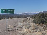
. From there, the highway makes its way east through the mountainous terrain and the Lida Summit (elevation 7420 feet (2,261.6 m)) to the community of Lida.
Once it exits the town, the route continues east through the open desert. SR 266 reaches its eastern terminus at the Lida Junction, an intersection with US 95 14 miles (22.5 km) south of Goldfield
. On the south side of the highway is the Lida Junction Airport
—which was originally built to provide more convenient access to the now defunct Cottontail Ranch
, located immediately southwest of the highway junction.
 SR 266 originally began as the southernmost segment of State Route 3, one of Nevada's first four state highways designated with the creation of the Nevada Department of Highways in 1917. Maps dating back to 1917 show SR 3 curving northward a few miles east of Lida on its trek towards Goldfield and points further north. The eastern portion of the present-day route was constructed as a graded highway by 1937, with the new alignment replacing the unimproved northeast leg by 1940. The entire alignment was paved by 1960.
SR 3 was officially eliminated from the state highway system as part of a mass renumbering of Nevada's state routes. State Route 266 was assigned to this former alignment of SR 3 on July 1, 1976. The resulting change in the highway's number was first seen on the 1978–79 edition of the official highway map.
State highway
State highway, state road or state route can refer to one of three related concepts, two of them related to a state or provincial government in a country that is divided into states or provinces :#A...
in Esmeralda County
Esmeralda County, Nevada
Esmeralda County is a county in the west of U.S. state of Nevada. Its county seat is Goldfield. Its 2000 census population was officially 971, making its population density 0.1045 inhabitants/km² , the second-lowest of any county-equivalent outside of Alaska. As of 2010, the population had...
, Nevada
Nevada
Nevada is a state in the western, mountain west, and southwestern regions of the United States. With an area of and a population of about 2.7 million, it is the 7th-largest and 35th-most populous state. Over two-thirds of Nevada's people live in the Las Vegas metropolitan area, which contains its...
, USA. It connects the routing of California State Route 266
California State Route 266
State Route 266 is a state highway in the U.S. state of California. The route is a connector between Nevada State Route 264 and Nevada State Route 266, and it can serve as transportation of agricultural goods between California and Nevada via the route's only junction State Route 168...
east to U.S. Route 95
U.S. Route 95 in Nevada
In the U.S. state of Nevada, U.S. Route 95 is a major U.S. highway traversing the state from north to south directly through Las Vegas and providing connections to both Carson City and Reno...
(US 95) via the town of Lida
Lida, Nevada
Lida, Nevada is a small town in Esmeralda County, Nevada, near the border with California. It is located on State Route 266, north of Magruder Mountain....
. Lida Road previously carried the southern end of State Route 3
Nevada State Route 3
State Route 3 was the original designation for SR 208, SR 266 and SR 429. It was also the original designation for sections of SR 430, US 50, US 95, Alternate US 95, and US 395....
.
Route description
California
California is a state located on the West Coast of the United States. It is by far the most populous U.S. state, and the third-largest by land area...
state line about 4 miles (6.4 km) east of Oasis, California
Oasis, Mono County, California
Oasis is an unincorporated community in Mono County, California. It is located in Fish Lake Valley east-southeast of Mount Bancroft. Oasis is at the junction of California State Route 266 and California State Route 168. The 2000 Census reports that Oasis had a population of 22.A post office...
. From there, the highway makes its way east through the mountainous terrain and the Lida Summit (elevation 7420 feet (2,261.6 m)) to the community of Lida.
Once it exits the town, the route continues east through the open desert. SR 266 reaches its eastern terminus at the Lida Junction, an intersection with US 95 14 miles (22.5 km) south of Goldfield
Goldfield, Nevada
Goldfield is an unincorporated community and the county seat of Esmeralda County, Nevada, United States, with a resident population of 440 at the 2000 census. It is located about southeast of Carson City, along U.S...
. On the south side of the highway is the Lida Junction Airport
Lida Junction Airport
Lida Junction Airport is a public-use airport located 14 miles south of the central business district of Goldfield, in Esmeralda County, Nevada, United States. The airport is owned by the United States Bureau of Land Management.- Facilities :...
—which was originally built to provide more convenient access to the now defunct Cottontail Ranch
Cottontail Ranch
Cottontail Ranch was a legal, licensed brothel in Nevada that opened in October 1967. Located near the intersection of U.S. Route 95 and State Route 266 known as Lida Junction, in Esmeralda County, Nevada...
, located immediately southwest of the highway junction.
History
SR 3 was officially eliminated from the state highway system as part of a mass renumbering of Nevada's state routes. State Route 266 was assigned to this former alignment of SR 3 on July 1, 1976. The resulting change in the highway's number was first seen on the 1978–79 edition of the official highway map.