

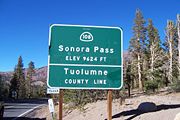
Sonora Pass
Encyclopedia
Sonora Pass is the second-highest highway pass
in the Sierra Nevada, lower by 321 ft. (about 98 m.) than Tioga Pass
to the south. State Route 108
traverses the pass.
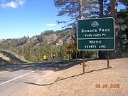
to the west and Bridgeport
to the east. Like most high Sierra Nevada passes, the highway is closed in winter, generally between November and May, due to snow accumulation.
The highway over the pass is extremely steep (up to 26% in some locations), narrow and winding between Kennedy Meadows on the west side and Leavitt Meadows on the east. The route is not recommended for vehicles or vehicle combinations that are unusually wide, heavy or long.
 The Pacific Crest Trail
, a 2,650 mile (4,240 km) long National Scenic Trail
, crosses Highway 108 at Sonora Pass.
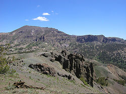
Adjacent to the Pass is a picnic/parking area, which serves as a day-use rest stop or a trailhead for hikes to nearby Sonora Peak
, Wolf Creek Lake, and other spots north or south along the Pacific Crest Trail.
, but the U.S. Forest Service indicates they crossed north of Sonora Pass in the Carson-Iceberg area.
With the discovery of deposits and development of silver and gold mining east of the Sierra Nevada in the beginning of the 1860s, merchant interests in the counties on both sides of the pass pushed for development of a road that would enable them to improve transportation and trade. Surveying for a road through Sonora Pass began in 1863 and the road was in use by 1865.
In the 1880(s) the California and Nevada Railroad
and its predecessor, the California and Mount Diablo Railroad, proposed to run a narrow gauge railroad over Sonora Pass with a line running from Emeryville - Stockton and then connecting with the Denver and Rio Grande Railroad in Utah. The railroad never built track beyond the San Francisco Bay Area.
In 1943, the location scenes for the mountainous hideout of the Republican Spanish guerilla band in For Whom the Bell Tolls
were filmed here.
Mountain pass
A mountain pass is a route through a mountain range or over a ridge. If following the lowest possible route, a pass is locally the highest point on that route...
in the Sierra Nevada, lower by 321 ft. (about 98 m.) than Tioga Pass
Tioga Pass
Tioga Pass is a mountain pass in the Sierra Nevada mountains of California. State Route 120 runs through it, and serves as the eastern entry point for Yosemite National Park. It is the highest highway pass in California and in the Sierra Nevada. Mount Dana is to the east of the pass...
to the south. State Route 108
California State Route 108
State Route 108, also known as Highway 108, is a numbered state highway in California. SR 108 runs generally northeast across central California from downtown Modesto near the SR 99/SR 132 interchange, crossing the Sierra Nevada at Sonora Pass, to U.S. Route 395 near the Nevada state line...
traverses the pass.
Description
The pass connects the communities of SonoraSonora, California
Sonora is the county seat of Tuolumne County, California. As of the 2010 census, the city population was 4,903, up from 4,423 at the 2000 census. Sonora is the only incorporated community in Tuolumne County.-Geography:...
to the west and Bridgeport
Bridgeport, California
Bridgeport is a census-designated place that is the county seat of Mono County, California. It lies at an elevation of 6463 feet in the middle of the Bridgeport Valley. Bridgeport is located at the intersection of highways US 395 and State Route 182. The population was 575 at the 2010...
to the east. Like most high Sierra Nevada passes, the highway is closed in winter, generally between November and May, due to snow accumulation.
The highway over the pass is extremely steep (up to 26% in some locations), narrow and winding between Kennedy Meadows on the west side and Leavitt Meadows on the east. The route is not recommended for vehicles or vehicle combinations that are unusually wide, heavy or long.
Pacific Crest Trail
The Pacific Crest Trail is a long-distance mountain hiking and equestrian trail on the Western Seaboard of the United States. The southern terminus is at the California border with Mexico...
, a 2,650 mile (4,240 km) long National Scenic Trail
National Scenic Trail
National Scenic Trail is a designation for protected areas in the United States that consist of trails of particular natural beauty.National Scenic Trails were authorized under the National Trails System Act of 1968 along with National Historic Trails and National Recreation Trails...
, crosses Highway 108 at Sonora Pass.
Adjacent to the Pass is a picnic/parking area, which serves as a day-use rest stop or a trailhead for hikes to nearby Sonora Peak
Sonora Peak
Sonora Peak is a mountain located in the Central Sierra Nevada mountains of California north of Sonora Pass. Located on the boundary between Alpine and Mono counties, it is the highest point in Alpine County. Due to the high elevation, most of the precipitation this mountain receives consists of...
, Wolf Creek Lake, and other spots north or south along the Pacific Crest Trail.
History
The first documented immigrant traverse of Sonora Pass appears to have been in the late summer of 1852 by a wagon train known as the Clark-Skidmore Company. Subsequently, merchant interests in the communities of Sonora and Columbia promoted the route to California-bound immigrants, not always with happy results when immigrants discovered how difficult it was. There are some references indicating the earliest immigrant crossing was in 1841 by the Bartleson-Bidwell PartyBartleson-Bidwell Party
In 1841, the Bartleson–Bidwell Party led by Captain John Bartleson and John Bidwell, became the first American emigrants to attempt a wagon crossing from Missouri to California.-The trail:...
, but the U.S. Forest Service indicates they crossed north of Sonora Pass in the Carson-Iceberg area.
With the discovery of deposits and development of silver and gold mining east of the Sierra Nevada in the beginning of the 1860s, merchant interests in the counties on both sides of the pass pushed for development of a road that would enable them to improve transportation and trade. Surveying for a road through Sonora Pass began in 1863 and the road was in use by 1865.
In the 1880(s) the California and Nevada Railroad
California and Nevada Railroad
The California and Nevada Railroad was a steam narrow gauge railroad which ran in the East Bay of the San Francisco Bay Area in the late 19th century. It was incorporated on March 25, 1884. J.S. Emery was listed as the railroad's president, for which present day Emeryville is named. On March 1,...
and its predecessor, the California and Mount Diablo Railroad, proposed to run a narrow gauge railroad over Sonora Pass with a line running from Emeryville - Stockton and then connecting with the Denver and Rio Grande Railroad in Utah. The railroad never built track beyond the San Francisco Bay Area.
In 1943, the location scenes for the mountainous hideout of the Republican Spanish guerilla band in For Whom the Bell Tolls
For Whom the Bell Tolls (film)
For Whom the Bell Tolls is a 1943 film in Technicolor based on the novel of the same name by Ernest Hemingway. It stars Gary Cooper, Ingrid Bergman, Akim Tamiroff and Katina Paxinou. This was Ingrid Bergman's first technicolor film. Hemingway handpicked Cooper and Bergman for their roles. The film...
were filmed here.