

U.S. Route 395 in Nevada
Encyclopedia
In the U.S. state
of Nevada
, U.S. Route 395 (US 395) clips a corner of Nevada near Lake Tahoe
and serves the cities of Gardnerville
, Minden
, Carson City
and Reno
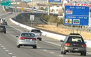
. Most of US 395 north of Carson City is a freeway and is built up to Interstate standards. Part of the freeway section is also currently designated as unsigned Interstate 580
.
 U.S. 395 enters Nevada at Topaz Lake
as a two lane highway and gradually winds its way to Carson Valley
where it becomes the principal thoroughfare for the Minden-Gardnerville area. Upon entering the Carson Valley 395 becomes a 4 lane highway through Minden
and Gardnerville
. Upon leaving Minden the highway becomes a 4 lane divided highway and turns due north towards Carson City.
 The highway currently serves as Carson Street, the main street of Carson City
. However, a freeway bypass is currently under construction, with the northern half open to traffic. Temporarily US 395, and US 50, are routed along Fairview Drive to connect the freeway and Carson Street. This freeway is planned to become Interstate 580
but is currently signed as US 395.
Upon exiting Carson City, the highway continues north through Washoe Valley. Midway through Washoe Valley the freeway portion temporarily ends. The highway also crosses Pleasant Valley before entering Reno. A new freeway portion through Pleasant Valley
is also currently under construction. Upon entering Reno
the freeway portion resumes as a 6 lane freeway and is designated the Martin Luther King Jr. freeway. The highway heads north to intersect Interstate 80 near downtown Reno. Shortly afterward, US 395 turns northwest to serve the north valleys of greater Reno area before returning to California at Bordertown.
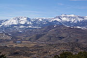
The entire route through Nevada closely follows the eastern edge of the Sierra Nevada range. Several prominent peaks are visible from the highway, including Jobs Peak
and Mount Rose
.
|-
|rowspan=7|Douglas
0.00–33.96
|Topaz Lake
|0.00
|colspan=3 align=center|California state line
|-
|Holbrook Junction
|
|
|
|
|-
|Gardnerville
|
|
|
|
|-
|Minden
|
|
|
|
|-
|
|
|
|
|
|-
|
|
|
|
|
|-
|
|
|
|
|
|-
|rowspan=10 colspan=2|Carson City
0.00–9.56
|
|
|Clear Creek Road (SR 705
)
|
|-bgcolor=#ddffdd
|
|
|
|South end of US 50 & SR 529
overlap
|-
|
|
|Snyder Avenue (SR 518
)
|
|-bgcolor=#ddffdd
|
|
|
|North end of SR 529 overlap; South end of temporary US 395/50 alignment on Fairview Drive
|-
|rowspan=2|
|colspan=3 align=center|South end of freeway
|-
|38
|Fairview Drive
|Southbound exit and northbound entrance; North end of temporary US 395/50 alignment on Fairview Drive
|-bgcolor=#ddffdd
|
|39
|
|Serves Downtown Carson City; North end of US 50 overlap
|-
|
|41
|College Parkway (SR 531
)
|
|-
|
|42
|Arrowhead Drive
|Northbound exit and southbound entrance
|-
|
|43
|
|Southbound exit and northbound entrance
|-
|rowspan=30|Washoe
0.00–42.10
|
|
|44
|Eastlake Boulevard (to SR 429
)
|Former SR 428
; serves Washoe Lake State Park
|-
|
|
|46
|Bellevue Road
|
|-
|
|
|colspan=3 align=center|North end of freeway
|-
|Washoe City
|
|
|
|
|-
|rowspan=22|Reno
|
|
|
|
|-
|rowspan=2|
|colspan=3 align=center |South end of freeway
|-
|56
|
|Southbound exit and northbound entrance
|-
|
|57B
|
|Southbound exit and northbound entrance
|-
|
|57A
|South Virginia Street north (US 395 Bus. / SR 430
)
|Southbound exit and northbound entrance
|-
|
|59
|Damonte Ranch Parkway
|
|-
|
|60
|South Meadows Parkway (SR 426
)
|
|-
|
|61
|South Virginia Street (US 395 Bus. / SR 430
)
|
|-bgcolor=#ddffdd
|
|62
|Neil Road
|South end of unsigned I-580
overlap
|-
|
|63
|South Virginia Street (US 395 Bus.), Kietzke Lane
|Southbound exit and northbound entrance
|-
|
|64
|Moana Lane
|Serves Reno-Sparks Convention Center
|-
|
|65
| Plumb Lane (SR 653
), Villanova Drive – Reno-Tahoe International Airport
|Signed as exits 65A (Villanova Drive, Plumb Lane) and 65B (airport) southbound
|-
|
|66
|Mill Street
|
|-
|
|67
|East Second Street, Glendale Avenue (SR 648
)
|
|-bgcolor=#ddffdd
|
|68
|
|Signed as exits 68A (I-80 east) and 68B (I-80 west) northbound; North end of unsigned I-580
overlap
|-
|
|69
|Oddie Boulevard (SR 663
)
|
|-
|
|70
|North McCarran Boulevard (SR 659
), Clear Acre Lane (SR 443
)
|Signed as exits 70A (McCarran Boulevard) and 70B (Clear Acre Lane) northbound; serves Sun Valley
|-
|
|71
|Dandini Boulevard, Parr Boulevard
|
|-
|
|72
|Panther Valley (US 395 Bus.)
|to North Virginia Street
|-
|
|73
|Golden Valley Road
|
|-
|
|74
|Lemmon Drive
|
|-
|
|76
|Stead Boulevard (SR 673)
|Serves Reno-Stead Airport
|-
|
|
|78
|Red Rock Road
|
|-
|
|
|80
|Cold Springs Valley
|
|-
|
|
|83
|Bordertown
|
|-
|
|42.10
|colspan=3 align=center|North end of freeway / California state line
U.S. state
A U.S. state is any one of the 50 federated states of the United States of America that share sovereignty with the federal government. Because of this shared sovereignty, an American is a citizen both of the federal entity and of his or her state of domicile. Four states use the official title of...
of Nevada
Nevada
Nevada is a state in the western, mountain west, and southwestern regions of the United States. With an area of and a population of about 2.7 million, it is the 7th-largest and 35th-most populous state. Over two-thirds of Nevada's people live in the Las Vegas metropolitan area, which contains its...
, U.S. Route 395 (US 395) clips a corner of Nevada near Lake Tahoe
Lake Tahoe
Lake Tahoe is a large freshwater lake in the Sierra Nevada of the United States. At a surface elevation of , it is located along the border between California and Nevada, west of Carson City. Lake Tahoe is the largest alpine lake in North America. Its depth is , making it the USA's second-deepest...
and serves the cities of Gardnerville
Gardnerville, Nevada
Gardnerville is a census-designated place in Douglas County, Nevada, United States, adjacent to the county seat of Minden. The population was 3,357 at the 2000 census....
, Minden
Minden, Nevada
Minden is a census-designated place in Douglas County, Nevada, United States. The population was 2,836 at the 2000 census. It is the county seat of Douglas County and is adjacent to the city of Gardnerville. It is named after the town of Minden, in the German state of North Rhine-Westphalia. It...
, Carson City
Carson City, Nevada
The Consolidated Municipality of Carson City is the capital of the state of Nevada. The words Consolidated Municipality refer to a series of changes in 1969 which abolished Ormsby County and merged all the settlements contained within its borders into Carson City. Since that time Carson City has...
and Reno
Reno, Nevada
Reno is the county seat of Washoe County, Nevada, United States. The city has a population of about 220,500 and is the most populous Nevada city outside of the Las Vegas metropolitan area...
. Most of US 395 north of Carson City is a freeway and is built up to Interstate standards. Part of the freeway section is also currently designated as unsigned Interstate 580
Interstate 580 (Nevada)
Interstate 580 in Nevada is an unsigned Interstate Highway in northwestern Nevada. It runs concurrently with U.S. Route 395 in Reno, for approximately five miles between Interstate 80 and Neil Road. Two separate highway construction projects are currently underway along the US 395 corridor that...
.
Route description
Topaz Lake
Topaz Lake is a reservoir located on the California-Nevada border, about south of Reno.The lake was formed by diverting waters from the West Walker River into a nearby basin that had previously contained a smaller, natural lake. The initial construction took place in 1922, resulting in a...
as a two lane highway and gradually winds its way to Carson Valley
Douglas County, Nevada
Douglas County is a county located in the northwestern part of the U.S. state of Nevada. As of 2000, the population was 41,259. As of 2010, the population was estimated to be 46,997.- History :...
where it becomes the principal thoroughfare for the Minden-Gardnerville area. Upon entering the Carson Valley 395 becomes a 4 lane highway through Minden
Minden, Nevada
Minden is a census-designated place in Douglas County, Nevada, United States. The population was 2,836 at the 2000 census. It is the county seat of Douglas County and is adjacent to the city of Gardnerville. It is named after the town of Minden, in the German state of North Rhine-Westphalia. It...
and Gardnerville
Gardnerville, Nevada
Gardnerville is a census-designated place in Douglas County, Nevada, United States, adjacent to the county seat of Minden. The population was 3,357 at the 2000 census....
. Upon leaving Minden the highway becomes a 4 lane divided highway and turns due north towards Carson City.
Carson City, Nevada
The Consolidated Municipality of Carson City is the capital of the state of Nevada. The words Consolidated Municipality refer to a series of changes in 1969 which abolished Ormsby County and merged all the settlements contained within its borders into Carson City. Since that time Carson City has...
. However, a freeway bypass is currently under construction, with the northern half open to traffic. Temporarily US 395, and US 50, are routed along Fairview Drive to connect the freeway and Carson Street. This freeway is planned to become Interstate 580
Interstate 580 (Nevada)
Interstate 580 in Nevada is an unsigned Interstate Highway in northwestern Nevada. It runs concurrently with U.S. Route 395 in Reno, for approximately five miles between Interstate 80 and Neil Road. Two separate highway construction projects are currently underway along the US 395 corridor that...
but is currently signed as US 395.
Upon exiting Carson City, the highway continues north through Washoe Valley. Midway through Washoe Valley the freeway portion temporarily ends. The highway also crosses Pleasant Valley before entering Reno. A new freeway portion through Pleasant Valley
Pleasant Valley, Nevada
Pleasant Valley is a very small, unincorporated community in Washoe County, Nevada, United States. The ZIP Code for Pleasant Valley is 89511. The community is part of the Reno–Sparks Metropolitan Statistical Area, and US Route 395 runs through it, and acts as a divider between the eastern and...
is also currently under construction. Upon entering Reno
Reno, Nevada
Reno is the county seat of Washoe County, Nevada, United States. The city has a population of about 220,500 and is the most populous Nevada city outside of the Las Vegas metropolitan area...
the freeway portion resumes as a 6 lane freeway and is designated the Martin Luther King Jr. freeway. The highway heads north to intersect Interstate 80 near downtown Reno. Shortly afterward, US 395 turns northwest to serve the north valleys of greater Reno area before returning to California at Bordertown.
The entire route through Nevada closely follows the eastern edge of the Sierra Nevada range. Several prominent peaks are visible from the highway, including Jobs Peak
Jobs Peak
Jobs Peak, located in Alpine County, California, is the most prominent peak visible from the Carson Valley in Douglas County, Nevada. The peak offers hiking and backcountry skiing with the view of Lake Tahoe....
and Mount Rose
Mount Rose (Washoe County, Nevada)
Mount Rose is a mountain located in the Carson Range east of the California-Nevada border and is within the Mount Rose Wilderness. An extinct volcano, the mountain is located between Lake Tahoe and Reno;...
.
Major intersections
- Note: Mileposts in Nevada reset at county lines. Freeway exits are numbered according to statewide mileage.
|-
|rowspan=7|Douglas
Douglas County, Nevada
Douglas County is a county located in the northwestern part of the U.S. state of Nevada. As of 2000, the population was 41,259. As of 2010, the population was estimated to be 46,997.- History :...
0.00–33.96
|Topaz Lake
Topaz Lake
Topaz Lake is a reservoir located on the California-Nevada border, about south of Reno.The lake was formed by diverting waters from the West Walker River into a nearby basin that had previously contained a smaller, natural lake. The initial construction took place in 1922, resulting in a...
|0.00
|colspan=3 align=center|California state line
|-
|Holbrook Junction
|
|
|
|
|-
|Gardnerville
Gardnerville, Nevada
Gardnerville is a census-designated place in Douglas County, Nevada, United States, adjacent to the county seat of Minden. The population was 3,357 at the 2000 census....
|
|
|
|
|-
|Minden
Minden, Nevada
Minden is a census-designated place in Douglas County, Nevada, United States. The population was 2,836 at the 2000 census. It is the county seat of Douglas County and is adjacent to the city of Gardnerville. It is named after the town of Minden, in the German state of North Rhine-Westphalia. It...
|
|
|
|
|-
|
|
|
|
|
|-
|
|
|
|
|
|-
|
|
|
|
|
|-
|rowspan=10 colspan=2|Carson City
Carson City, Nevada
The Consolidated Municipality of Carson City is the capital of the state of Nevada. The words Consolidated Municipality refer to a series of changes in 1969 which abolished Ormsby County and merged all the settlements contained within its borders into Carson City. Since that time Carson City has...
0.00–9.56
|
|
|Clear Creek Road (SR 705
Nevada State Route 705
State Route 705, named Old Clear Creek Road, runs from the BIA Water Diversion Box along Old Clear Creek Road to U.S. Route 395 south of Carson City, Nevada....
)
|
|-bgcolor=#ddffdd
|
|
|
|South end of US 50 & SR 529
Nevada State Route 529
State Route 529 is a state highway in Carson City, Nevada, USA. The route follows Carson Street, the principal north–south arterial through the city. The southern portion of the unsigned highway currently carries U.S. Route 50 and U.S. Route 395 through the city, while the remainder of the...
overlap
|-
|
|
|Snyder Avenue (SR 518
Nevada State Route 518
State Route 518 is a short state highway in Carson City, Nevada serving the state's Stewart Complex. The route originated as State Route 36.-Route description:...
)
|
|-bgcolor=#ddffdd
|
|
|
|North end of SR 529 overlap; South end of temporary US 395/50 alignment on Fairview Drive
|-
|rowspan=2|
|colspan=3 align=center|South end of freeway
|-
|38
|Fairview Drive
|Southbound exit and northbound entrance; North end of temporary US 395/50 alignment on Fairview Drive
|-bgcolor=#ddffdd
|
|39
|
|Serves Downtown Carson City; North end of US 50 overlap
|-
|
|41
|College Parkway (SR 531
Nevada State Route 531
State Route 531 was a state highway in Carson City, Nevada. It followed a portion of College Parkway in the northern part of the city. Created by 1995, the highway was turned over to city control in 2011.-Route description:...
)
|
|-
|
|42
|Arrowhead Drive
|Northbound exit and southbound entrance
|-
|
|43
|
|Southbound exit and northbound entrance
|-
|rowspan=30|Washoe
Washoe County, Nevada
Washoe County is a county located in the U.S. state of Nevada. The population was 421,407 at the 2010 census. Its county seat is Reno. Washoe County includes the Reno-Sparks metropolitan area.-History:...
0.00–42.10
|
|
|44
|Eastlake Boulevard (to SR 429
Nevada State Route 429
State Route 429 is a rural state highway located in southern Washoe County, Nevada. It is named Bowers Mansion Road and is a former alignment of U.S. Route 395 .-Route description:...
)
|Former SR 428
Nevada State Route 428
State Route 428 is a former highway in Washoe County, Nevada. It followed Eastlake Boulevard through New Washoe City and along the east side of Washoe Lake, providing access to Washoe Lake State Park. The road was formerly known as State Route 3B.-Route description:State Route 428 began at U.S...
; serves Washoe Lake State Park
Washoe Lake State Park
Washoe Lake State Park is a state park of Nevada, USA, on Washoe Lake. It is between the cities of Carson City and Reno near U.S. Route 395 and just east of Lake Tahoe. It is in the Western Nevada Region of Nevada State Parks. The park is open for year-round recreation including, hunting, fishing,...
|-
|
|
|46
|Bellevue Road
|
|-
|
|
|colspan=3 align=center|North end of freeway
|-
|Washoe City
|
|
|
|
|-
|rowspan=22|Reno
Reno, Nevada
Reno is the county seat of Washoe County, Nevada, United States. The city has a population of about 220,500 and is the most populous Nevada city outside of the Las Vegas metropolitan area...
|
|
|
|
|-
|rowspan=2|
|colspan=3 align=center |South end of freeway
|-
|56
|
|Southbound exit and northbound entrance
|-
|
|57B
|
|Southbound exit and northbound entrance
|-
|
|57A
|South Virginia Street north (US 395 Bus. / SR 430
Nevada State Route 430
State Route 430 is a major north–south state highway in Washoe County, Nevada which currently exists as two separate sections. South of Reno, the route follows the Carson-Reno Highway, and currently overlaps U.S. Route 395. In Reno, the highway follows Virginia Street, the primary...
)
|Southbound exit and northbound entrance
|-
|
|59
|Damonte Ranch Parkway
|
|-
|
|60
|South Meadows Parkway (SR 426
Nevada State Route 426
State Route 426 is a short, unsigned state highway in the South Meadows area of Reno in Washoe County, Nevada. It comprises a short segment of South Meadows Parkway.-Route description:...
)
|
|-
|
|61
|South Virginia Street (US 395 Bus. / SR 430
Nevada State Route 430
State Route 430 is a major north–south state highway in Washoe County, Nevada which currently exists as two separate sections. South of Reno, the route follows the Carson-Reno Highway, and currently overlaps U.S. Route 395. In Reno, the highway follows Virginia Street, the primary...
)
|
|-bgcolor=#ddffdd
|
|62
|Neil Road
|South end of unsigned I-580
Interstate 580 (Nevada)
Interstate 580 in Nevada is an unsigned Interstate Highway in northwestern Nevada. It runs concurrently with U.S. Route 395 in Reno, for approximately five miles between Interstate 80 and Neil Road. Two separate highway construction projects are currently underway along the US 395 corridor that...
overlap
|-
|
|63
|South Virginia Street (US 395 Bus.), Kietzke Lane
|Southbound exit and northbound entrance
|-
|
|64
|Moana Lane
|Serves Reno-Sparks Convention Center
|-
|
|65
| Plumb Lane (SR 653
Nevada State Route 653
State Route 653 is an east–west state highway in Nevada serving Reno.-Route description:SR 653 begins at Kietzke Lane in Reno, and proceeds east along Plumb Lane to end at the intersection with Terminal Way at the entrance to the Reno-Tahoe International Airport.-History:As late as 2006,...
), Villanova Drive – Reno-Tahoe International Airport
|Signed as exits 65A (Villanova Drive, Plumb Lane) and 65B (airport) southbound
|-
|
|66
|Mill Street
|
|-
|
|67
|East Second Street, Glendale Avenue (SR 648
Nevada State Route 648
State Route 648 runs from Kietzke Lane east along East Second Street in Reno and Glendale Avenue in Sparks to South McCarran Boulevard .- Route description :SR 648 begins at State Route 667 in Reno at Kietzke Lane...
)
|
|-bgcolor=#ddffdd
|
|68
|
|Signed as exits 68A (I-80 east) and 68B (I-80 west) northbound; North end of unsigned I-580
Interstate 580 (Nevada)
Interstate 580 in Nevada is an unsigned Interstate Highway in northwestern Nevada. It runs concurrently with U.S. Route 395 in Reno, for approximately five miles between Interstate 80 and Neil Road. Two separate highway construction projects are currently underway along the US 395 corridor that...
overlap
|-
|
|69
|Oddie Boulevard (SR 663
Nevada State Route 663
State Route 663 is an east–west state highway in Nevada serving the Reno-Sparks area.-Route description:SR 663 begins at Sutro Street in Reno and proceeds east along Oddie Boulevard to Pyramid Way SR 445 in Sparks.-History:...
)
|
|-
|
|70
|North McCarran Boulevard (SR 659
Nevada State Route 659
State Route 659 is a state highway in Washoe County, Nevada. The route follows McCarran Boulevard, an arterial ring road serving the cities of Reno and Sparks. The route provides access to many businesses and residential areas in the Truckee Meadows....
), Clear Acre Lane (SR 443
Nevada State Route 443
State Route 443 is a state highway in the Reno-Sparks metropolitan area of the state of Nevada. It is the main connection between the city of Reno and the community of Sun Valley to the north...
)
|Signed as exits 70A (McCarran Boulevard) and 70B (Clear Acre Lane) northbound; serves Sun Valley
Sun Valley, Nevada
Sun Valley is a census-designated place in Washoe County, Nevada, USA. The population was 19,461 at the 2000 census. It is a northern suburb of the city of Reno and is part of the Reno–Sparks Metropolitan Statistical Area.-Geography:...
|-
|
|71
|Dandini Boulevard, Parr Boulevard
|
|-
|
|72
|Panther Valley (US 395 Bus.)
|to North Virginia Street
|-
|
|73
|Golden Valley Road
|
|-
|
|74
|Lemmon Drive
|
|-
|
|76
|Stead Boulevard (SR 673)
|Serves Reno-Stead Airport
|-
|
|
|78
|Red Rock Road
|
|-
|
|
|80
|Cold Springs Valley
Cold Springs, Nevada
Cold Springs is a census-designated place in Washoe County, Nevada, United States. It is located just off U.S. Route 395 in the northwestern part of the Reno–Sparks Metropolitan Statistical Area, adjacent to the California state line...
|
|-
|
|
|83
|Bordertown
|
|-
|
|42.10
|colspan=3 align=center|North end of freeway / California state line