
Netherton, Sefton
Encyclopedia
Netherton is a suburb of liverpool in the Metropolitan Borough of Sefton, Merseyside
, England.
and north east of the centre of Bootle
, Netherton is also north of Litherland
and to the west of Aintree
. Netherton also neighbours Sefton Village.
Netherton is a mostly residential area, although it is widely considered to be divided between Netherton Village, (which consists of privately owned housing) and includes the old Netherton Village Green; and the large council estate built by Bootle Borough Council on the other side of the Leeds and Liverpool Canal
.
The estate is unusual in the fact that many of the houses are still occupied by the same residents who moved in as young couples (many of the men had seen active service during the Second World War) with families when the houses were brand new. The social profile of the first resident population does not comply to modern notions of council estate dwellers. Many of these people were hard working people with middle class aspirations, whose lives and careers were interrupted and often changed forever by the Second World War. However, the demographics of the Netherton area have changed significantly over time. A large number of the male residents moved in from all parts of the country to be key skilled workers at the English Electric factory heavy engineering works on Dunnings Bridge Road.
The main part of Netherton which is centred around Marian Square, was a large council estate, built in the mid 1950s, to alleviate housing shortages in Bootle after the heavy bombing the town suffered during the Second World War. Historical records show that of about 18,000 houses in Bootle, only about 1,000 survived the German bombings completely intact. A remaining 16,000 houses were partially damaged and over a thousand completely destroyed. (Most people only associate the Blitz with London, but actually Bootle, with its large number of docks, was worse hit. All the major Atlantic Convoys sailed out of Liverpool and Bootle docks).
The Sefton Estate (which includes Stonyfield, Waterside, Harrops Croft and Higher End Park) was built by Lancashire County Council some ten years after the Netherton estate in the mid 1960s and were the first council houses in the area to have central heating
.
Marian Square is opposite the health centre in Magdalene Square (the two squares are divided by Glovers Lane, and should not be confused). The first shops (approximately five, including a health clinic and opticians) were built on Magdalene Square and were later demolished when the new shops and first new post office on Marian Square were opened. The original plans for the redevelopment for Magdalene Square, which were on view as a model in Bootle Town Hall in 1965, were for a 22 storey tower block and a leisure complex including swimming pool. Neither of which were built (probably due to a lack of further investment in the area).
There were also plans for a large ring road to link the motorways at Switch Island, running across fields to the north of the Sefton estate with the centre of Bootle and the landward side of Crosby
, along a corridor of land which included the Rimrose Valley. The council compusorily purchased land along this corridor but the road was never built. There is a large mound of earth next to the small church near the Cabbage Inn (near the present fire station); which shows the start of the earthworks for the flyover linking the proposed ring road to the goods depot on the railway line near the Girobank building on Netherton Way. The proposed ring road is shown on some old Liverpool A to Z street plans.
The unused land in the Rimrose Valley was made into an area of parkland, and new houses are finally being built on the old allotments at the other end of the Rimrose Valley in Litherland.
There is another housing estate built prior to the Marian Square development. Nicknamed 'Dodge City', it is situated across Dunningsbridge Road between the main housing area and Aintree Racecourse
, adjacent to the old English Electric factory. Contrary to misguided notions that this name is due to deprivation or crime rates; the area was called 'Dodge City' because of the excess amounts of sand present whilst building work commenced; in recent years however the nickname 'Dodge City' has come to be applied to the whole of Netherton by those ignorant of its origins. And other origins of 'Dodge City' are from when the bus only came twice a day through there hence it 'dodging' the location.
Notable firms which hold, or once held, premises in Netherton include:- Braby's; English Electric; Forticrete; Metal Box; Movie (cleaning products); National Girobank; Peerless Refining Co.; North West Timber; Porter Chadburn; Post Office Telecommunications (British Telecom.); Scott's Bakery (now part of Allied Bakeries) and now the site of a large trading estate including cinema, Matalan store and a pub called the Bakers Dozen; Wimpey and to Alliance and Leicester.
Netherton was formerly the home of the Everton F.C.
youth academy, which has now been relocated to Finch Farm
. The land was previously a fire station (the old brick building on the site) and the grounds of Littlewoods Social Club. This area has now been turned into a Goals football centre.
associated with the parish
of Sefton, becoming an independent civil parish in 1866. It became part of Sefton Rural District
under the Local Government Act 1894
, and then West Lancashire Rural District
in 1932.
Netherton parish lost areas to the county borough
of Bootle
in 1940, 1951 and 1968 (reducing the parish from 1124 acres (5 km²) in 1931 to 469 acres (1.9 km²) in 1951). The residual parish no longer exists, forming part of Sefton parish.
The area has been a part of the Metropolitan Borough of Sefton since local government reorganisation on 1 April 1974.
For parliamentary elections
Netherton is within the Bootle
constituency represented by the Labour Party
MP Joe Benton
.
For elections to Sefton Council
Netherton is split between the electoral wards of Netherton and Orrell
, whose three representatives, who are members of the Labour Party
, are Susan Ellen Bradshaw, Robert John Brennan, and Ian Ralph Maher. And St. Oswald, whose three representatives, who are also members of the Labour Party
, are Mark Dowd, Peter Dowd and James Mahon. Overall there are 6 councillors representing the Netherton area and they are all members of the Labour Party
.
. The old catholic church of St. Benet
nearby was built in 1793. Unusually it appears as an ordinary house from the road with the church backing onto what was once open fields. A modern church was built over the road in the 1970s.
Nowadays, Netherton is formed with many modern housing, the most recent being the George Wimpey
estate, completed in 2000, built just 100 yards (91.4 m) from Netherton Village green. Housing in this part of Netherton is considered rather desirable, unlike the council-owned housing closer to the town's shopping amenities.
. Formerly there were Bootle Grammar School and Warwick Bolam County Secondary School as well as a Girl's County Secondary School. In August 2009, Bootle High School
closed its doors for the last time as students transferred to Litherland High School
. In December 2009, works started to demolish the school on Browns Lane.
Now however the properties on the council estate are mostly privatly owned and were bought under the right to buy scheme
brought in by the conservative government under Margaret Thatcher.
and Old Roan
, on the Northern Line
of the Merseyrail
network. The Old Roan station is technically in Aintree, but is on the border between the two areas. Old Roan bus station is next to the railway-station. Buses run from here and Magdalene Square into central Liverpool
(those from Magdalene Square also serve parts of Bootle
) as well as North to Maghull
, Ormskirk
and Southport
.
The area is situated close to the major interchange, Switch Island
, at the end of the M57
and M58
motorways.
The Leeds and Liverpool Canal
flows through Netherton and whilst this provides a local amenity, there is very little boat traffic on this stretch of its course.
Merseyside
Merseyside is a metropolitan county in North West England, with a population of 1,365,900. It encompasses the metropolitan area centred on both banks of the lower reaches of the Mersey Estuary, and comprises five metropolitan boroughs: Knowsley, St Helens, Sefton, Wirral, and the city of Liverpool...
, England.
Description
Situated in north LiverpoolLiverpool
Liverpool is a city and metropolitan borough of Merseyside, England, along the eastern side of the Mersey Estuary. It was founded as a borough in 1207 and was granted city status in 1880...
and north east of the centre of Bootle
Bootle
Bootle is a town within the Metropolitan Borough of Sefton in Merseyside, England, and a 'Post town' in the L postcode area. Formally known as Bootle-cum-Linacre, the town is 4 miles to the north of Liverpool city centre, and has a total resident population of 77,640.Historically part of...
, Netherton is also north of Litherland
Litherland
Litherland is a suburban village in the Metropolitan Borough of Sefton, Merseyside, England. It was formerly an urban district, which included Seaforth and Ford...
and to the west of Aintree
Aintree
Aintree is a village and civil parish in the Metropolitan Borough of Sefton, Merseyside. It lies between Walton and Maghull on the A59 road, about north of Liverpool city centre, in North West England....
. Netherton also neighbours Sefton Village.
Netherton is a mostly residential area, although it is widely considered to be divided between Netherton Village, (which consists of privately owned housing) and includes the old Netherton Village Green; and the large council estate built by Bootle Borough Council on the other side of the Leeds and Liverpool Canal
Leeds and Liverpool Canal
The Leeds and Liverpool Canal is a canal in Northern England, linking the cities of Leeds and Liverpool. Over a distance of , it crosses the Pennines, and includes 91 locks on the main line...
.
The estate is unusual in the fact that many of the houses are still occupied by the same residents who moved in as young couples (many of the men had seen active service during the Second World War) with families when the houses were brand new. The social profile of the first resident population does not comply to modern notions of council estate dwellers. Many of these people were hard working people with middle class aspirations, whose lives and careers were interrupted and often changed forever by the Second World War. However, the demographics of the Netherton area have changed significantly over time. A large number of the male residents moved in from all parts of the country to be key skilled workers at the English Electric factory heavy engineering works on Dunnings Bridge Road.
The main part of Netherton which is centred around Marian Square, was a large council estate, built in the mid 1950s, to alleviate housing shortages in Bootle after the heavy bombing the town suffered during the Second World War. Historical records show that of about 18,000 houses in Bootle, only about 1,000 survived the German bombings completely intact. A remaining 16,000 houses were partially damaged and over a thousand completely destroyed. (Most people only associate the Blitz with London, but actually Bootle, with its large number of docks, was worse hit. All the major Atlantic Convoys sailed out of Liverpool and Bootle docks).
The Sefton Estate (which includes Stonyfield, Waterside, Harrops Croft and Higher End Park) was built by Lancashire County Council some ten years after the Netherton estate in the mid 1960s and were the first council houses in the area to have central heating
Central heating
A central heating system provides warmth to the whole interior of a building from one point to multiple rooms. When combined with other systems in order to control the building climate, the whole system may be a HVAC system.Central heating differs from local heating in that the heat generation...
.
Marian Square is opposite the health centre in Magdalene Square (the two squares are divided by Glovers Lane, and should not be confused). The first shops (approximately five, including a health clinic and opticians) were built on Magdalene Square and were later demolished when the new shops and first new post office on Marian Square were opened. The original plans for the redevelopment for Magdalene Square, which were on view as a model in Bootle Town Hall in 1965, were for a 22 storey tower block and a leisure complex including swimming pool. Neither of which were built (probably due to a lack of further investment in the area).
There were also plans for a large ring road to link the motorways at Switch Island, running across fields to the north of the Sefton estate with the centre of Bootle and the landward side of Crosby
Crosby, Merseyside
Crosby is a town in the Metropolitan Borough of Sefton, in Merseyside, England. Historically part of Lancashire it is situated north of Bootle, south of Southport, Formby and west of Netherton-History:...
, along a corridor of land which included the Rimrose Valley. The council compusorily purchased land along this corridor but the road was never built. There is a large mound of earth next to the small church near the Cabbage Inn (near the present fire station); which shows the start of the earthworks for the flyover linking the proposed ring road to the goods depot on the railway line near the Girobank building on Netherton Way. The proposed ring road is shown on some old Liverpool A to Z street plans.
The unused land in the Rimrose Valley was made into an area of parkland, and new houses are finally being built on the old allotments at the other end of the Rimrose Valley in Litherland.
There is another housing estate built prior to the Marian Square development. Nicknamed 'Dodge City', it is situated across Dunningsbridge Road between the main housing area and Aintree Racecourse
Aintree Racecourse
Aintree Racecourse is a racecourse in Aintree, Merseyside, England.It was served by Aintree Racecourse railway station until the station closed in the 1960s....
, adjacent to the old English Electric factory. Contrary to misguided notions that this name is due to deprivation or crime rates; the area was called 'Dodge City' because of the excess amounts of sand present whilst building work commenced; in recent years however the nickname 'Dodge City' has come to be applied to the whole of Netherton by those ignorant of its origins. And other origins of 'Dodge City' are from when the bus only came twice a day through there hence it 'dodging' the location.
Notable firms which hold, or once held, premises in Netherton include:- Braby's; English Electric; Forticrete; Metal Box; Movie (cleaning products); National Girobank; Peerless Refining Co.; North West Timber; Porter Chadburn; Post Office Telecommunications (British Telecom.); Scott's Bakery (now part of Allied Bakeries) and now the site of a large trading estate including cinema, Matalan store and a pub called the Bakers Dozen; Wimpey and to Alliance and Leicester.
Netherton was formerly the home of the Everton F.C.
Everton F.C.
Everton Football Club are an English professional association football club from the city of Liverpool. The club competes in the Premier League, the highest level of English football...
youth academy, which has now been relocated to Finch Farm
Finch Farm
Finch Farm is the training ground for Everton F.C., in the Liverpool suburb of Halewood.The School of Science is the nickname given to the complex by some supporters, referring to a long-standing nickname for the club. The training ground houses both the Everton first team and the youth academy...
. The land was previously a fire station (the old brick building on the site) and the grounds of Littlewoods Social Club. This area has now been turned into a Goals football centre.
History & local government
Netherton was anciently a townshipTownship (England)
In England, a township is a local division or district of a large parish containing a village or small town usually having its own church...
associated with the parish
Parish
A parish is a territorial unit historically under the pastoral care and clerical jurisdiction of one parish priest, who might be assisted in his pastoral duties by a curate or curates - also priests but not the parish priest - from a more or less central parish church with its associated organization...
of Sefton, becoming an independent civil parish in 1866. It became part of Sefton Rural District
Sefton Rural District
Sefton was a rural district in Lancashire, England from 1894 to 1932.It was created by the Local Government Act 1894 based on West Derby rural sanitary district...
under the Local Government Act 1894
Local Government Act 1894
The Local Government Act 1894 was an Act of the Parliament of the United Kingdom that reformed local government in England and Wales outside the County of London. The Act followed the reforms carried out at county level under the Local Government Act 1888...
, and then West Lancashire Rural District
West Lancashire Rural District
West Lancashire was a rural district from 1894 to 1974 in Lancashire, England. It was created with other rural districts in 1894, based on the Ormskirk rural sanitary district...
in 1932.
Netherton parish lost areas to the county borough
County borough
County borough is a term introduced in 1889 in the United Kingdom of Great Britain and Ireland , to refer to a borough or a city independent of county council control. They were abolished by the Local Government Act 1972 in England and Wales, but continue in use for lieutenancy and shrievalty in...
of Bootle
Bootle
Bootle is a town within the Metropolitan Borough of Sefton in Merseyside, England, and a 'Post town' in the L postcode area. Formally known as Bootle-cum-Linacre, the town is 4 miles to the north of Liverpool city centre, and has a total resident population of 77,640.Historically part of...
in 1940, 1951 and 1968 (reducing the parish from 1124 acres (5 km²) in 1931 to 469 acres (1.9 km²) in 1951). The residual parish no longer exists, forming part of Sefton parish.
The area has been a part of the Metropolitan Borough of Sefton since local government reorganisation on 1 April 1974.
For parliamentary elections
Parliament of the United Kingdom
The Parliament of the United Kingdom of Great Britain and Northern Ireland is the supreme legislative body in the United Kingdom, British Crown dependencies and British overseas territories, located in London...
Netherton is within the Bootle
Bootle (UK Parliament constituency)
Bootle is a borough constituency represented in the House of Commons of the Parliament of the United Kingdom. It elects one Member of Parliament by the first past the post system of election. Since 1990 the MP has been Joe Benton of the Labour Party...
constituency represented by the Labour Party
Labour Party (UK)
The Labour Party is a centre-left democratic socialist party in the United Kingdom. It surpassed the Liberal Party in general elections during the early 1920s, forming minority governments under Ramsay MacDonald in 1924 and 1929-1931. The party was in a wartime coalition from 1940 to 1945, after...
MP Joe Benton
Joe Benton
Joseph Edward Benton is a British Labour Party politician who has been the Member of Parliament for Bootle since 1990.-Early life:...
.
For elections to Sefton Council
Sefton Metropolitan Borough Council
Sefton Council is the governing body for the Metropolitan Borough of Sefton in Merseyside, north-western England. The council has been under no overall control since the 1980s and is run as an all party coalition of the Liberal Democrats, the Labour Party and the Conservative Party, It consists of...
Netherton is split between the electoral wards of Netherton and Orrell
Netherton and Orrell (ward)
Netherton and Orrell is a Metropolitan Borough of Sefton ward in the Bootle Parliamentary constituency that covers the southern part of the locality of Netherton, and all of the area of Orrell.-Councillors:-Elections of the 2010s:...
, whose three representatives, who are members of the Labour Party
Labour Party (UK)
The Labour Party is a centre-left democratic socialist party in the United Kingdom. It surpassed the Liberal Party in general elections during the early 1920s, forming minority governments under Ramsay MacDonald in 1924 and 1929-1931. The party was in a wartime coalition from 1940 to 1945, after...
, are Susan Ellen Bradshaw, Robert John Brennan, and Ian Ralph Maher. And St. Oswald, whose three representatives, who are also members of the Labour Party
Labour Party (UK)
The Labour Party is a centre-left democratic socialist party in the United Kingdom. It surpassed the Liberal Party in general elections during the early 1920s, forming minority governments under Ramsay MacDonald in 1924 and 1929-1931. The party was in a wartime coalition from 1940 to 1945, after...
, are Mark Dowd, Peter Dowd and James Mahon. Overall there are 6 councillors representing the Netherton area and they are all members of the Labour Party
Labour Party (UK)
The Labour Party is a centre-left democratic socialist party in the United Kingdom. It surpassed the Liberal Party in general elections during the early 1920s, forming minority governments under Ramsay MacDonald in 1924 and 1929-1931. The party was in a wartime coalition from 1940 to 1945, after...
.
Architecture
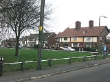
The oldest houses are to be found at the heart of the old hamlet of Netherton, clustered around the green in what is now known as Netherton Village, just north of the Leeds and Liverpool CanalLeeds and Liverpool Canal
The Leeds and Liverpool Canal is a canal in Northern England, linking the cities of Leeds and Liverpool. Over a distance of , it crosses the Pennines, and includes 91 locks on the main line...
. The old catholic church of St. Benet
St Benet's Chapel, Netherton
St Benet's Chapel, Netherton, is a redundant Roman Catholic chapel in Chapel Lane, Netherton, Liverpool, Merseyside, England. The chapel and the attached priest's house have been designated by English Heritage as a Grade II* listed building...
nearby was built in 1793. Unusually it appears as an ordinary house from the road with the church backing onto what was once open fields. A modern church was built over the road in the 1970s.
Nowadays, Netherton is formed with many modern housing, the most recent being the George Wimpey
George Wimpey
George Wimpey was formed in 1880 and, based in Hammersmith, operated largely as a road surfacing contractor. The business was acquired by Godfrey Mitchell in 1919 and he developed it into the UK’s pre-eminent construction and housebuilding firm. In 2007, Wimpey merged with Taylor Woodrow to create...
estate, completed in 2000, built just 100 yards (91.4 m) from Netherton Village green. Housing in this part of Netherton is considered rather desirable, unlike the council-owned housing closer to the town's shopping amenities.
Education
Netherton is home to two secondary schools, St. Ambrose Barlow Catholic High and Savio High SchoolSavio High School
Savio Salesian College is a Roman Catholic secondary school in Bootle, Merseyside, England. The school is under the care of the Salesians of Don Bosco and was successful in early 2006 to secure a bid for specialist Business & Enterprise status. The school has about 820 pupils on roll...
. Formerly there were Bootle Grammar School and Warwick Bolam County Secondary School as well as a Girl's County Secondary School. In August 2009, Bootle High School
Bootle High School
Bootle High School was located in Netherton, Merseyside, England. It closed in September 2009.-Staff & Pupils:The school, which catered for roughly 600 pupils between the ages of 11 to 16 years old, was under the headship of Mr P. Fryer...
closed its doors for the last time as students transferred to Litherland High School
Litherland High School
Litherland High School is a school in Litherland, Merseyside, England, headed by Mr Jim Donnelly since 1991. The address is Sterrix Lane, Litherland, Liverpool, Merseyside, L21 0DB . The school holds specialist Language College status, teaching many languages including Spanish, Italian, French,...
. In December 2009, works started to demolish the school on Browns Lane.
Now however the properties on the council estate are mostly privatly owned and were bought under the right to buy scheme
Right to buy scheme
The Right to buy scheme is a policy in the United Kingdom which gives tenants of council housing the right to buy the home they are living in. Currently, there is also a right to acquire for the tenants of housing associations...
brought in by the conservative government under Margaret Thatcher.
Transport
Netherton is served by two railway-stations: AintreeAintree railway station
Aintree railway station is a railway station in Aintree, Merseyside, England. It is on the Ormskirk branch of the Merseyrail network's Northern Line...
and Old Roan
Old Roan railway station
Old Roan railway station is a railway station in Aintree village, Merseyside, England, about seven miles north-east of Liverpool, on the Northern Line of the Merseyrail network.-Location:...
, on the Northern Line
Northern Line (Merseyrail)
The Northern Line is one of the two commuter rail lines operated by Merseyrail in Merseyside, England. The other line is the Wirral Line. A third line of the Merseyrail Network, the City Line, is not owned or operated by Merseyrail, although funded by Merseytravel.The Northern Line passes...
of the Merseyrail
Merseyrail
Merseyrail is a train operating company and commuter rail network in the United Kingdom, centred on Liverpool, Merseyside. The network is predominantly electric with diesel trains running on the City Line. Two City Line branches are currently being electrified on the overhead wire AC system with...
network. The Old Roan station is technically in Aintree, but is on the border between the two areas. Old Roan bus station is next to the railway-station. Buses run from here and Magdalene Square into central Liverpool
Liverpool
Liverpool is a city and metropolitan borough of Merseyside, England, along the eastern side of the Mersey Estuary. It was founded as a borough in 1207 and was granted city status in 1880...
(those from Magdalene Square also serve parts of Bootle
Bootle
Bootle is a town within the Metropolitan Borough of Sefton in Merseyside, England, and a 'Post town' in the L postcode area. Formally known as Bootle-cum-Linacre, the town is 4 miles to the north of Liverpool city centre, and has a total resident population of 77,640.Historically part of...
) as well as North to Maghull
Maghull
Maghull is a town and civil parish within the Metropolitan Borough of Sefton, in Merseyside, England. The town is located eight miles north of the City of Liverpool and south of Ormskirk in West Lancashire. The area of Moss Side also contains HM Prison Kennet and Ashworth Hospital. Maghull had a...
, Ormskirk
Ormskirk
Ormskirk is a market town in West Lancashire, England. It is situated north of Liverpool city centre, northwest of St Helens, southeast of Southport and southwest of Preston.-Geography and administration:...
and Southport
Southport
Southport is a seaside town in the Metropolitan Borough of Sefton in Merseyside, England. During the 2001 census Southport was recorded as having a population of 90,336, making it the eleventh most populous settlement in North West England...
.
The area is situated close to the major interchange, Switch Island
Switch Island
Switch Island is a road junction south of Maghull and near Aintree in Merseyside, England on the Liverpool rural-urban fringe. The junction is at the western terminus of both the M57 and M58 motorways, which converge on the A59 trunk road, the north-south route from Liverpool...
, at the end of the M57
M57 motorway
The M57 motorway, also known as the Liverpool Outer Ring Road, is a road in England. Designed as a bypass road for Liverpool, it is long and links various towns east of the city, as well as the M62 and M58 motorways.-Route:...
and M58
M58 motorway
The M58 is a motorway passing through Merseyside and Lancashire, terminating in Greater Manchester, England. It is 12 miles long and provides a link between the M6 motorway and the area north of Liverpool.-Route:...
motorways.
The Leeds and Liverpool Canal
Leeds and Liverpool Canal
The Leeds and Liverpool Canal is a canal in Northern England, linking the cities of Leeds and Liverpool. Over a distance of , it crosses the Pennines, and includes 91 locks on the main line...
flows through Netherton and whilst this provides a local amenity, there is very little boat traffic on this stretch of its course.