

Neighborhoods of Norwich, Connecticut
Encyclopedia
Norwich, Connecticut
Regular steamship service between New York and Boston helped Norwich to prosper as a shipping center through the early part of the 20th century. During the Civil War, Norwich once again rallied and saw the growth of its textile, armaments, and specialty item manufacturing...
maintain independent identities and are recognized by official signs marking their boundaries. The following is a list of neighborhoods in Norwich.
Bean Hill
Bean Hill was originally a separate village, located about a mile from the center of Norwich in close proximity to the Norwichtown Green. It was originally founded by a group of EpiscopalianEpiscopal Church (United States)
The Episcopal Church is a mainline Anglican Christian church found mainly in the United States , but also in Honduras, Taiwan, Colombia, Ecuador, Haiti, the Dominican Republic, Venezuela, the British Virgin Islands and parts of Europe...
s around a small green (now a public park). In the early 19th century it was the site of the Norwich Methodist Episcopal Church, which met in a building that also housed a classical academy and a free school. The African American
African American
African Americans are citizens or residents of the United States who have at least partial ancestry from any of the native populations of Sub-Saharan Africa and are the direct descendants of enslaved Africans within the boundaries of the present United States...
abolitionist David Ruggles
David Ruggles
David Ruggles was an anti-slavery activist who was active in the New York Committee of Vigilance and the Underground Railroad. He was an "African-American printer in New York City during the 1830s", who "was the prototype for black activist journalists of his time"...
grew up in Bean Hill and had an Underground Railroad
Underground Railroad
The Underground Railroad was an informal network of secret routes and safe houses used by 19th-century black slaves in the United States to escape to free states and Canada with the aid of abolitionists and allies who were sympathetic to their cause. The term is also applied to the abolitionists,...
stop in this area in one of the houses. Several of the old colonial houses and the Episcopal Church (now a photographic and investment business) still stand. Modern Bean Hill grew in all directions with the coming of a highway on and off ramp depositing into the area just below the green. This area is now commercial with numerous gas stations, a Courtyard Marriott
Marriott International
Marriott International, Inc. is a worldwide operator and franchisor of a broad portfolio of hotels and related lodging facilities. Founded by J. Willard Marriott, the company is now led by son J.W. Marriott, Jr...
and a park and ride
Park and ride
Park and ride facilities are car parks with connections to public transport that allow commuters and other people wishing to travel into city centres to leave their vehicles and transfer to a bus, rail system , or carpool for the rest of their trip...
. Extending out from the Green are more commercial establishments, small shopping centers and, to the northeast, residential neighborhoods. The copper company Phelps Dodge
Phelps Dodge
Phelps Dodge Corporation was an American mining company founded in 1834 by Anson Greene Phelps and William Earle Dodge, Sr.. On March 19, 2007, it was acquired by Freeport-McMoRan and now operates under the name Freeport-McMoRan Copper & Gold Inc.-History:...
is located in the farther reaches of Bean Hill next to old mills.
Chelsea or Downtown
Because of its location at the Y-fork of the ThamesThames River (Connecticut)
The Thames River is a short river and tidal estuary in the U.S. state of Connecticut. It flows south for through eastern Connecticut from the junction of the Yantic and Shetucket rivers at Norwich, to New London and Groton, which flank its mouth at the Long Island Sound.Differing from its...
, Shetucket
Shetucket River
The Shetucket River is a tributary of the Thames River, long, in eastern Connecticut in the United States.It is formed at Willimantic by the junction of the Willimantic and Natchaug rivers. It flows southeast and south...
and Yantic River
Yantic River
The Yantic River forms at the confluence of the Deep River, Sherman Brook, and Exeter Brook about east of Colchester, Connecticut. It runs for and flows into the Shetucket River in Norwich, forming the Thames River...
s, Chelsea became the home of the city's former shipping harbor
Harbor
A harbor or harbour , or haven, is a place where ships, boats, and barges can seek shelter from stormy weather, or else are stored for future use. Harbors can be natural or artificial...
located on Hollyhock Island. Because of Norwich's industrial and commercial nature, this neighborhood is quite large, with its borders extending from Washington Street in the west to Burnham Square in the east.
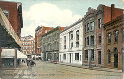
At the core of Norwich's downtown are the harbor and a dense grouping of 18th-century buildings that are still mostly intact. The majority of big business, including the Wauregan Hotel, Reid and Hughes, Sears, Woolworth's and Chelsea Groton Bank, developed around Centennial Square before moving out of the city or to East Great Plain with the economic tide. Numerous churches and historic homes, the YMCA of Southeastern Connecticut and Post Office are also in and around Chelsea. The old train station and tracks are located here also, along with the City Hall, New London County Superior Court, CLA Engineers and the Otis Library. The oldest remaining building in the city, Chelsea Landing Pub, is located here as well. The main public areas in this district are Centennial Square, City Hall Square and Howard T. Brown Memorial Park. The offices of the Norwich Bulletin are located in the Sunshine Building and the main newspaper building on Franklin Street in the north, just below the SBC
SBC
-Colleges and institutes:*Sanford-Brown College, system of for-profit schools in the United States*San Beda College, of Manila, Philippines*Sarawak Biodiversity Centre, Sarawak state biology research institute in Malaysia...
Offices next to City Hall. The original Otis Library was in a small brick building across the square from City Hall. It moved to the more modern and spacious State Building on Main Street due to increased population.
When the businesses moved across the water and downstate after shipping moved to New London, Chelsea declined greatly. Most businesses went defunct, including the Wauregan Hotel. Most of the buildings became carcasses and quickly fell into disrepair. It was renamed the Chelsea Arts District for the remaining theaters such as the Donald L. Oat and Spirit of Broadway. Hollyhock Island became home to a pleasure craft marina on the south end and a decaying industrial zone with a sewage treatment plant on the north end. The train station was abandoned and later converted into a soup kitchen
Soup kitchen
A soup kitchen, a bread line, or a meal center is a place where food is offered to the hungry for free or at a reasonably low price. Frequently located in lower-income neighborhoods, they are often staffed by volunteer organizations, such as church groups or community groups...
.
Today, the economic slump has tapered off and Chelsea is experiencing a revival. The Wauregan Hotel, Chelsea Landing and Otis Library/State Building are all undergoing large-scale renovations and will soon be reopened for mixed residential and commercial use. A Mercantile Exchange was recently built along the waterfront and for the remaining abandoned buildings there is much talk among developers as to how to reuse them. Although not completely salvaged, Hollyhock Island was freed of the abandoned Duffy Mill complex. Today there is talk of either having a transport hub or a theme park on this island. Utopia Studios had recently expressed interest in a large-scale development project in Downtown, the result of which would have been two thirty-seven story condominium towers located around Howard T. Brown Memorial Park and commercial developments, but it didn't meet approvals. Theaters have remained in the area, notably the Donald L. Oat (run by the Norwich Arts Council) and the Spirit of Broadway. Art galleries, offices, new shops and bars have opened in the downtown area, many occupying previously abandoned buildings and storefronts. The old Laurel Hill Bridge was also gutted and replaced by a more modern, secure structure with Victorian theme lightposts and flower boxes.
East Great Plains (or Westside)
Named from at least 1890, this section of Norwich is located in the southwest part of the city and is centered around the junction of New London Turnpike and Route 82. Three Rivers Community College, the Norwich Ice Rink and the Norwich Public Golf Course are located in East Great Plains. Stanton Elementary School is located in East Great Plains next to the second of Norwich's synagogues, Beth Jacob.East Side
On the Shetucket River and hills just northeast of Laurel Hill, this is a largely ethnic neighborhood on East Main Street and Hamilton Avenue. When first occupied, this district was dominated by Italian immigrants and later Poles. Haitians, Hispanics and most recently Asians have made this neighborhood their home. Anglo Saxon families have integrated the neighborhood as well, providing for a true melting pot. The area has not lost its ethnic character, as new Asian grocery stores open up alongside old Italian shops.Before water services were extended across the Shetucket, the East Side was watered by a spring up in the hills above Talman Street. The water would flow down and be collected by families at a communal fountain. Recently in a local ceremony, the fountain was reestablished in a small flowered alcove underneath a parking lot. This landmark of the East Side is observable from the intersection of Talman Street and East Main Street where it comes off the Preston Bridge.
The Thames River Academy is located on the East Side.
Greeneville (or Greenville)
The Greeneville section of Norwich Connecticut was named by William Greene. In 1826, Greene purchased land on both sides of the Shetucket River to develop. In 1828, he transferred the land to the Norwich Water Power Company, in which he was the largest shareholder. Norwich Water Power Company began construction on a dam in 1829. By 1833, the dam and canals were finished and capable of providing water power to 40,000 to 50,000 spindleSpindle (tool)
In machine tools, a spindle is a rotating axis of the machine, which often has a shaft at its heart. The shaft itself is called a spindle, but also, in shop-floor practice, the word often is used metonymically to refer to the entire rotary unit, including not only the shaft itself, but its bearings...
s. Mills were quickly built along the Shetucket River during the mid-19th century to take advantage of this water power. The remains of the original dam may still be seen upstream of the present dam.
Greeneville was originally settled by Irish immigrants who established St. Mary's Church in 1845, making it the oldest Catholic church in eastern Connecticut. The original structure still exists as Savage Hardware Store. The current church, completed in 1867, is located on Central Avenue. While originally Irish, it now also serves growing Hispanic and Haitian populations, regularly offering masses in Spanish
Spanish language
Spanish , also known as Castilian , is a Romance language in the Ibero-Romance group that evolved from several languages and dialects in central-northern Iberia around the 9th century and gradually spread with the expansion of the Kingdom of Castile into central and southern Iberia during the...
and Creole
Haitian Creole language
Haitian Creole language , often called simply Creole or Kreyòl, is a language spoken in Haiti by about twelve million people, which includes all Haitians in Haiti and via emigration, by about two to three million speakers residing in the Bahamas, Cuba, Canada, France, Cayman Islands, French...
.
The Greeneville Dam Fishing Area provides fishing and boating access to the Shetucket River at the site of a fish ladder
Fish ladder
A fish ladder, also known as a fishway, fish pass or fish steps, is a structure on or around artificial barriers to facilitate diadromous fishes' natural migration. Most fishways enable fish to pass around the barriers by swimming and leaping up a series of relatively low steps into the waters on...
and dam operated by Norwich Public Utilities.
Schools in Greenville include the Hickory Street School.
Greeneville's Neighborhood Revitalization Zone committee is active in keeping the Greeneville section friendly for families and small businesses.
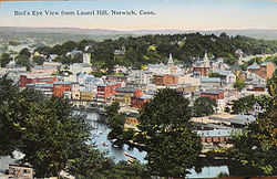
Jail Hill
Located just above downtown, this district once featured a hilltop prison. It is now a quiet residential area with winding streets and view of the rest of the city.Laurel Hill
Integrated Day Charter School
In 1989, the Integrated Day Program of Norwich, Connecticut was established within the existing public school system. In 1997, Joan Heffernan, June Morrone, and Joyce Werden helped to create an alternative school, as a free public school choice, for all members of the Norwich community and...
. The Norwich portion of the now-defunct Norwich State Hospital is located on the very south end of Laurel Hill along with an abandoned planned community that is considered part of the former psychiatric hospital.
There is also an apartment community right before the abandoned hospital called Thames View Apartments with a fire department right next to it.
Veterans' Memorial Elementary School and the former Laurel Hill Neighborhood School make up this neighborhood's educational dimensions.
Norwichtown
Located in north central Norwich, Norwichtown is the old town of Norwich, where the town's founders first settled. The Norwichtown Green is surrounded by many historic houses and shops (now converted into law practices, nursing homes or bed and breakfasts) such as the John Mason School (now the central administration for the Norwich Public School System) and First Congregational Church. The neighborhood includes two historic districts: the Norwichtown Historic DistrictNorwichtown Historic District
The Norwichtown Historic District is a historic district in the Norwichtown section of the town of Norwich, Connecticut. It was listed on the National Register of Historic Places in 1973. By then, the district was already a local historic district...
and Chelsea Parade Green. Open space in the area includes Mohegan Park and Indian Leap Park. Norwich Free Academy, the Slater Museum, and the DAR Museum are in Norwichtown.
Occum
Named after Samson OccomSamson Occom
The Reverend Samson Occom was a Native American Presbyterian clergyman and a member of the Mohegan nation near New London, Connecticut...
, this was another milltown that was later incorporated into Norwich. Like Greenville, it is located on the Shetucket River. The old mill and dam have since been demolished. Occum contains a small business center with a fire station and public park. The rest is devoted to residential housing and churches extending all the way into Baltic.
Plans and schematics for a the new Occum Country Club golf course with eight-hundred condominium units have been announced. The new developments will take place on an old farm property.
The golf course and luxury condominium plans fell through with the collapse of the Utopia negotiations. The farmland is currently for sale.
Ox Hill
Located just to the northeast of Washington Street and Broadway, Ox Hill is predominantly residential and recreational. The Norwich Vocational Technical High School will occupy the Mohegan Campus of Three Rivers Community College starting January 2009, when the Mohegan Campus merges in with the Thames Valley campus. Thomas J. Kelly Junior High School is right next to the community college campus. Across the road from Kelly are sports fields, courts and parks used by the Norwich Recreation Department. The Rose City Senior Center and three broadcast towers are located up here as well. The rest of the area is residential in nature with connections to Norwichtown. Mohegan Park is located on Ox Hill.Plain Hill
This gently sloping hill is located on the outskirts of Norwich, just above Bean Hill. It extends all the way up to the Sprague border. The area is entirely residential and very rural, with one main route (Plain Hill Road) connecting to side streets. Houses are few and far between in the more forested areas, while clearings can host several homes and a radio tower. Side streets lead off into smaller subdivisions.Wilcox Pond, and Bog Meadow Reservoirs, two of the city's backup reservoirs, are located on Plain Hill.
The city's meetinghouse for The Church of Jesus Christ of Latter-day Saints is located on Plain Hill near the Sprague border.
Taftville
Thamesville
Taking its name from the Thames River, this predominantly residential neighborhood hosts a few riverside businesses intermixed with houses on Route 32Route 32 (Connecticut)
Route 32 is a primary north–south state highway in the U.S. state of Connecticut, beginning in New London and continuing via Willimantic to the Massachusetts state line, where it continues as Route 32 in that state.-Route description:...
, the Norwich Police Department and the American Ambulance Headquarters along with another office building designed by Richard Sharpe and Associates. The Spa at Norwich Inn is located in the southern portion of Thamesville. Next to the Uncasville
Uncasville, Connecticut
Uncasville is an area in the town of Montville, Connecticut. The area traditionally known as Uncasville is a village in southeastern Montville, at the mouth of the Oxoboxo River...
border, a string of car dealerships has earned that portion of Route 32 the nickname, "Car Dealership Row." On nearby Shipping Street, the former Lehigh Oil Company complex is in the process of being converted into a riverfront development project.
Union Street
This is the in-between zone between Chelsea and Washington Street and Broadway. It contains a Baptist church on City Hall Square, several city offices and numerous houses stretching up the hill towards Little Plains Park.Washington Street and Broadway
This is the neighborhood between Chelsea and Norwichtown that stretches down the length of Washington Street and Broadway. During the city's economic booms during the Civil WarAmerican Civil War
The American Civil War was a civil war fought in the United States of America. In response to the election of Abraham Lincoln as President of the United States, 11 southern slave states declared their secession from the United States and formed the Confederate States of America ; the other 25...
and Reconstruction Period, this district became the playground of the rich. Numerous mansions, many of which still stand today, line Washington Street and Broadway while smaller houses exist behind them on side streets. Like Chelsea, during the economic slump Washington Street and Broadway also declined. The millionaires left and most of the mansions fell into states of disrepair. Recently, an effort has been undertaken to spruce up the neighborhood. Many of the mansions have been repaired and some converted to apartment spaces.
The largest structure in the city, Saint Patrick's Cathedral, stands at the intersection of Broadway and Union Street just above Little Plains Park. Built solely by the Irish immigrants to the city with dimes and wages, Saint Patrick's is a solid stone Roman Catholic cathedral, whose main steeple is the tallest structure in the city. The seat of the Roman Catholic Diocese of Norwich
Roman Catholic Diocese of Norwich
The Roman Catholic Diocese of Norwich is a Roman Catholic ecclesiastical territory or diocese in Connecticut in the northeastern United States. It was erected on August 6, 1953 by Pope Pius XII....
, Saint Patrick's property extends to the Chancery, Offices and Saint Patrick's School in surrounding buildings. Monsignor King Park just across the street commemorates a former Monsignor of the cathedral. Other prominent churches in the neighborhood include Park Congregational Church.
The Norwich Free Academy
Norwich Free Academy
The Norwich Free Academy founded in 1854 and in operation since 1856, is a high school located in the city of Norwich, Connecticut. The Academy serves as the primary high school for Norwich and the surrounding towns of Canterbury, Bozrah, Voluntown, Sprague, Lisbon, Franklin, Preston andseveral...
is just North of Saint Patrick's on Broadway.
Obelisk
An obelisk is a tall, four-sided, narrow tapering monument which ends in a pyramid-like shape at the top, and is said to resemble a petrified ray of the sun-disk. A pair of obelisks usually stood in front of a pylon...
dedicated to Christopher Columbus
Christopher Columbus
Christopher Columbus was an explorer, colonizer, and navigator, born in the Republic of Genoa, in northwestern Italy. Under the auspices of the Catholic Monarchs of Spain, he completed four voyages across the Atlantic Ocean that led to general European awareness of the American continents in the...
is located adjacent to the parade and across Crescent Street from the Norwich Free Academy. Across a small divider street from the tip of the parade is War Memorial Park, a small plot of land with memorials to veterans of foreign wars and POW-MIAs. Around Chelsea Parade is the Masonic Temple, now demolished in order to preserve and ancient Mohegan Indian burial ground, the Blackstone Apartments and smaller mansions. Up in the area of Sachem and Asylum Streets is Heritage Falls Park and Indian Leap, where a young Mohegan leaped over the Yantic Falls to escape pursuing Narragansett Indians.
This district extends up to the Norwichtown welcome sign on Washington Street.
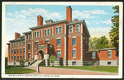
Right between Norwichtown and end of Washington Street lies the William W. Backus Hospital on 326 Washington street. Dedicated in 1893, Backus Hospital is named for William Wolcott Backus, a member of one of Norwich's oldest families who (along with William Albert Slater) led the effort to build it. Today, Backus is the city’s largest non-government employer.
Yantic
Due to the planned nature of the milltowns that are now part of Norwich, Yantic contains a grid pattern street with mill house duplexes and Grace Church. The original mill, abandoned for years, is now being converted into a prominent resort hotel. The hotel project, plagued by financial and construction mis-management since 1995, has been unfortunately, the latest failed struggle to revitalize the economic vitality of the once thriving village.