
Nehalem River
Encyclopedia
The Nehalem River is a river on the Pacific
coast of northwest Oregon
in the United States
, approximately 119 miles (191.5 km) long. It drains part of the Northern Oregon Coast Range
northwest of Portland
, originating on the east side of the mountains and flowing in a loop around the north end of the range near the mouth Columbia River
. Its watershed of 855 square miles (2,214.4 km²) includes an important timber-producing region of Oregon that was the site of the Tillamook Burn
. In its upper reaches it flows through long narrow valley of small mountain communities but is unpopulated along most of its lower reaches inland from the coast.
It rises in the northeast corner of Tillamook County
, in the Tillamook State Forest
. It initially flows northeast, across the northwest corner of Washington County
and into western Columbia County
, past Vernonia
and Pittsburg
. At Pittsburg, it looks to the northwest and west into Clatsop County
, then flows southwest back into northern Tillamook County. It enters Nehalem Bay
on the Pacific in an estuary
at Nehalem
, about 70 miles (112.7 km) west-northwest of Portland. Near its mouth on the Pacific, the river passes under U.S. Route 101
.
It receives the Salmonberry River
from the east in northern Tillamook County. It receives the North Fork Nehalem River 25 miles (40.2 km) from the north about 2 miles (3.2 km) northwest of Nehalem, just before entering Nehalem Bay.
Pacific Ocean
The Pacific Ocean is the largest of the Earth's oceanic divisions. It extends from the Arctic in the north to the Southern Ocean in the south, bounded by Asia and Australia in the west, and the Americas in the east.At 165.2 million square kilometres in area, this largest division of the World...
coast of northwest Oregon
Oregon
Oregon is a state in the Pacific Northwest region of the United States. It is located on the Pacific coast, with Washington to the north, California to the south, Nevada on the southeast and Idaho to the east. The Columbia and Snake rivers delineate much of Oregon's northern and eastern...
in the United States
United States
The United States of America is a federal constitutional republic comprising fifty states and a federal district...
, approximately 119 miles (191.5 km) long. It drains part of the Northern Oregon Coast Range
Northern Oregon Coast Range
The Northern Oregon Coast Range is the northern section of the Oregon Coast Range, in the Pacific Coast Ranges physiographic region, located in the northwest portion of the state of Oregon, United States. This section of the mountain range, part of the Pacific Coast Ranges, contains peaks as high...
northwest of Portland
Portland, Oregon
Portland is a city located in the Pacific Northwest, near the confluence of the Willamette and Columbia rivers in the U.S. state of Oregon. As of the 2010 Census, it had a population of 583,776, making it the 29th most populous city in the United States...
, originating on the east side of the mountains and flowing in a loop around the north end of the range near the mouth Columbia River
Columbia River
The Columbia River is the largest river in the Pacific Northwest region of North America. The river rises in the Rocky Mountains of British Columbia, Canada, flows northwest and then south into the U.S. state of Washington, then turns west to form most of the border between Washington and the state...
. Its watershed of 855 square miles (2,214.4 km²) includes an important timber-producing region of Oregon that was the site of the Tillamook Burn
Tillamook Burn
The Tillamook Burn was a series of forest fires in the Northern Oregon Coast Rangeof Oregon in the United States that destroyed a total area of 355,000 acres of old growth timber in what is now known as the Tillamook State Forest. The fires spanned the years of 1933–1951. By association, the name...
. In its upper reaches it flows through long narrow valley of small mountain communities but is unpopulated along most of its lower reaches inland from the coast.
It rises in the northeast corner of Tillamook County
Tillamook County, Oregon
Tillamook County is a county located in the U.S. state of Oregon. The county is named for the Tillamook, a Native American tribe who were living in the area in the early 19th century at the time of European American settlement. In 2010, the county's population was 25,250...
, in the Tillamook State Forest
Tillamook State Forest
The Tillamook State Forest is a publicly owned forest in the U.S. state of Oregon. Managed by the Oregon Department of Forestry, it is located west of Portland in the Northern Oregon Coast Range, and spans Washington, Tillamook, Yamhill, and Clatsop counties. The forest receives large amounts of...
. It initially flows northeast, across the northwest corner of Washington County
Washington County, Oregon
- Major highways :* Interstate 5* Interstate 205* U.S. Route 26* Oregon Route 6* Oregon Route 8* Oregon Route 10* Oregon Route 47* Oregon Route 99W* Oregon Route 210* Oregon Route 217* Oregon Route 219-Demographics:...
and into western Columbia County
Columbia County, Oregon
Columbia County is a county located in the U.S. state of Oregon. It was named for the Columbia River, which forms its eastern and northern borders. As of 2010, its population was 49,351. The county seat is St. Helens.-Economy:...
, past Vernonia
Vernonia, Oregon
Vernonia is a city in Columbia County, Oregon, United States. The city is located on the Nehalem River, in a valley on the eastern side of the Northern Oregon Coast Range. It is located the heart of the most important timber-producing areas of the state, and logging has played an important role in...
and Pittsburg
Pittsburg, Oregon
Pittsburg is an unincorporated community in Columbia County, Oregon, United States. Pittsburg is located on the Nehalem River near its confluence with the East Fork Nehalem River. The Scappose-Vernonia road and the St. Helens-Pittsburg road join Oregon Route 47 near Pittsburg...
. At Pittsburg, it looks to the northwest and west into Clatsop County
Clatsop County, Oregon
Clatsop County is a county located in the U.S. state of Oregon. The county is named for the Clatsop tribe of Native Americans, who lived along the coast of the Pacific Ocean prior to European settlement. As of 2010, the population was 37,039. The county seat is Astoria.-Economy:The principal...
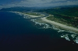
, then flows southwest back into northern Tillamook County. It enters Nehalem Bay
Nehalem Bay
The Nehalem Bay is a bay formed by the confluence of the Nehalem River into the Pacific Ocean in northern Oregon.The city of Nehalem is situated on US Highway 101 between Garibaldi in the south and Cannon Beach in the north....
on the Pacific in an estuary
Estuary
An estuary is a partly enclosed coastal body of water with one or more rivers or streams flowing into it, and with a free connection to the open sea....
at Nehalem
Nehalem, Oregon
Nehalem is a city in Tillamook County, Oregon, United States. Incorporated in 1889, the city is located on the Nehalem River at Nehalem Bay of the Pacific Ocean. It is bisected by U.S. Route 101. The population was 203 at the 2000 census.-History:...
, about 70 miles (112.7 km) west-northwest of Portland. Near its mouth on the Pacific, the river passes under U.S. Route 101
U.S. Route 101
U.S. Route 101, or U.S. Highway 101, is an important north–south U.S. highway that runs through the states of California, Oregon, and Washington, on the West Coast of the United States...
.
It receives the Salmonberry River
Salmonberry River
The Salmonberry River is a tributary of the Nehalem River, approximately 20 mi long, in northwest Oregon in the United States. It drains a remote unpopulated area of the Northern Oregon Coast Range in the Tillamook State Forest approximately 65 mi WNW of Portland...
from the east in northern Tillamook County. It receives the North Fork Nehalem River 25 miles (40.2 km) from the north about 2 miles (3.2 km) northwest of Nehalem, just before entering Nehalem Bay.