

National Register of Historic Places listings in Westmoreland County, Pennsylvania
Encyclopedia
This is intended to be a complete list of the properties and districts on the National Register of Historic Places
National Register of Historic Places
The National Register of Historic Places is the United States government's official list of districts, sites, buildings, structures, and objects deemed worthy of preservation...
in Westmoreland County
Westmoreland County, Pennsylvania
-Demographics:As of the census of 2000, there were 369,993 people, 149,813 households, and 104,569 families residing in the county. The population density was 361 people per square mile . There were 161,058 housing units at an average density of 157 per square mile...
, Pennsylvania
Pennsylvania
The Commonwealth of Pennsylvania is a U.S. state that is located in the Northeastern and Mid-Atlantic regions of the United States. The state borders Delaware and Maryland to the south, West Virginia to the southwest, Ohio to the west, New York and Ontario, Canada, to the north, and New Jersey to...
, United States
United States
The United States of America is a federal constitutional republic comprising fifty states and a federal district...
. The locations of National Register properties and districts for which the latitude and longitude coordinates are included below, may be seen in a Google map.
There are 52 properties and districts listed on the National Register in the county. One site is further designated as a National Historic Landmark
National Historic Landmark
A National Historic Landmark is a building, site, structure, object, or district, that is officially recognized by the United States government for its historical significance...
. Another property was once listed but has been removed.
Current listings
| Landmark name | Image | Date listed | Location | City or Town | Summary | |
|---|---|---|---|---|---|---|
| 1 | Academy Hill Historic District | 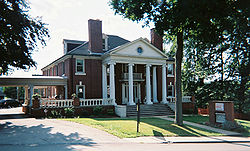 |
Roughly bounded by Baughman Street, North Maple Avenue, Kenneth Street, Culbertson Avenue, Beacon Street, and Pennsylvania Avenue 40°18′39"N 79°32′42"W |
Greensburg Greensburg, Pennsylvania Greensburg is a city in Westmoreland County, Pennsylvania, United States, and a part of the Pittsburgh Metro Area. The city is named after Nathanael Greene, a major general of the Continental Army in the American Revolutionary War... |
||
| 2 | Allegheny River Lock and Dam No. 4 Allegheny River Lock and Dam No. 4 The Allegheny River Lock and Dam No. 4 in Harrison Township, Allegheny County, Pennsylvania, is a lock that was built in 1927. The lock and dam were built by the U.S. Army Corps of Engineers as a part of an extensive system of locks and dams to improve navigation along the Allegheny River. It was... |
1 River Avenue 40°36′52"N 79°42′59"W |
Lower Burrell Lower Burrell, Pennsylvania Lower Burrell is a city in Westmoreland County in the U.S. state of Pennsylvania. Located approximately 18 miles northeast of Downtown Pittsburgh, Lower Burrell is part of the Pittsburgh Metro Area... |
Extends into Harrison Township Harrison Township, Allegheny County, Pennsylvania Harrison Township is a township in Allegheny County, Pennsylvania, United States. The population was 10,461 at the 2010 census. Pennsylvania Route 28 passes through Harrison Township connecting Kittanning to the northeast and Pittsburgh to the southwest. Allegheny Technologies has extensive steel... in Allegheny County |
||
| 3 | Bells Mills Covered Bridge | West of Yukon 40°13′9"N 79°42′37"W |
Sewickley and South Huntingdon Townships | |||
| 4 | Brush Creek Salems Church | Southeast of Westmoreland City on Brush Creek Road 40°19′9"N 79°39′30"W |
Hempfield Township Hempfield Township, Westmoreland County, Pennsylvania Hempfield Township is a township in Westmoreland County, Pennsylvania, United States. The population was 43,241 at the 2010 census, making it the largest suburb in the Pittsburgh Metropolitan Area by population.- Geography :... |
|||
| 5 | Brush Hill | 651 Brush Hill Road 40°19′30"N 79°41′22"W |
Irwin Irwin, Pennsylvania Irwin is a borough in Westmoreland County, Pennsylvania, southeast of Pittsburgh. Some of the most extensive bituminous coal deposits in the State are located here. In the past, iron foundries, flour mills, car shops, facing and planing mills, electrical goods, and mirror factories provided... |
|||
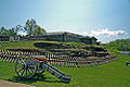
| 6 | Bushy Run Battlefield Bushy Run Battlefield Bushy Run Battlefield Park is a historical park that was operated by the Pennsylvania Historical and Museum Commission, on , in Penn Township, Westmoreland County, Pennsylvania in the United States. It was the site of the Battle of Bushy Run fought on August 5 - 6, 1763 during the Pontiac's Rebellion... |
 |
2 miles (3.2 km) east of Harrison City on Pennsylvania Route 993 Pennsylvania Route 993 Pennsylvania Route 993 is a long state highway located in Westmoreland county in Pennsylvania. The western terminus is at Pennsylvania Route 130 in Trafford. The eastern terminus is at PA 66 Business in Hempfield Township... 40°21′21"N 79°37′30"W |
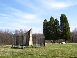
Penn Township Penn Township, Westmoreland County, Pennsylvania Penn Township is a township in Westmoreland County, Pennsylvania, United States.-Geography:According to the United States Census Bureau, the township has a total area of 30.5 square miles , all of it land.-Demographics:... |
||
| 7 | Byerly House | 115 Menk Road, east of New Kensington 40°33′14"N 79°41′1"W |
Upper Burrell Township | |||
| 8 | Charleroi-Monessen Bridge | Legislative Route 247 over the Monongahela River Monongahela River The Monongahela River is a river on the Allegheny Plateau in north-central West Virginia and southwestern Pennsylvania in the United States... 40°9′6"N 79°54′15"W |
Monessen Monessen, Pennsylvania Monessen is a city in Westmoreland County, Pennsylvania, United States. The population was 8,669 at the 2000 census. In 1940, 20,257 people lived there. In 1990 the population was 13,026. Steel-making was a prominent industry in Monessen, which was a Rust Belt borough in the "Mon Valley" of... |
Extends into North Charleroi North Charleroi, Pennsylvania North Charleroi is a borough in Washington County, Pennsylvania, United States. The population was 1,409 at the 2000 census.The city is also known as "Lock 4". Previously Lock and Dam #4 was located on this side of the Monongahela River, and the place had this name. Lock and Dam #4 was later... in Washington County |
||
| 9 | Citizens National Bank of Latrobe | 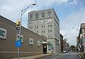 |
816 Ligonier Street 40°19′0"N 79°23′5"W |
Latrobe Latrobe, Pennsylvania Latrobe is a city in Westmoreland County, Pennsylvania in the United States, approximately southeast of Pittsburgh.The city population was 7,634 as of the 2000 census . It is located near the Pennsylvania's scenic Chestnut Ridge. Latrobe was incorporated as a borough in 1854, and as a city in 1999... |
||
| 10 | Compass Inn | Junction of U.S. Route 30 U.S. Route 30 U.S. Route 30 is an east–west main route of the system of United States Numbered Highways, with the highway traveling across the northern tier of the country. It is the third longest U.S. route, after U.S. Route 20 and U.S. Route 6. The western end of the highway is at Astoria, Oregon; the... (the Lincoln Highway) and California Avenue 40°12′43"N 79°11′57"W |
Ligonier Township | |||
| 11 | Dick Building | 201–203 East Main Street 40°12′6"N 79°46′0"W |
West Newton West Newton, Pennsylvania West Newton, located southeast of Pittsburgh, is a borough in Westmoreland County in the U.S. state of Pennsylvania. Formerly, the manufacture of radiators and boilers were the chief industries. In 1900, the people living there numbered 2,467. In 1910, 2,880 people lived there... |
|||
| 12 | Fairview Park | South side of Old Route 22, approximately 1.5 miles (2.4 km) east of Delmont Delmont, Pennsylvania Delmont is a borough in Westmoreland County, Pennsylvania, United States. The population was 2,497 at the 2000 census.-Geography:Delmont is located at .... 40°24′21"N 79°33′21.5"W |
Salem Township Salem Township, Westmoreland County, Pennsylvania Salem Township is a township in Westmoreland County, Pennsylvania, United States. The population was 6,939 at the 2000 census.-Geography:According to the United States Census Bureau, the township has a total area of 47.8 square miles , of which, 47.1 square miles of it is land and... |
|||
| 13 | Adam Fisher Homestead | Brinkerton Road near junction with Mount Pleasant Road, northwest of Calumet 40°13′9"N 79°30′10"W |
Mount Pleasant Township Mount Pleasant Township, Westmoreland County, Pennsylvania Mount Pleasant Township is a township in Westmoreland County, Pennsylvania, in the United States. As of the 2000 census, the township population was 11,153... |
|||
| 14 | Fort Ligonier Site Fort Ligonier Fort Ligonier is a British fortification from the French and Indian War located in Ligonier, Pennsylvania, United States. The fort served as a staging area for the Forbes Expedition of 1758. During the eight years of its existence as a garrison, Fort Ligonier was never taken by an enemy... |
 |
South Market Street 40°14′27"N 79°14′16"W |
Ligonier Ligonier, Pennsylvania Ligonier is a borough in Westmoreland County, Pennsylvania, United States. The population was 1,695 at the 2000 census. Ligonier was settled in the 1760s. The borough is well known for nearby Idlewild Park, one of the oldest amusement parks in the country, and nearby Seven Springs Mountain Resort... |
||
| 15 | Fullerton Inn | 11029 Old Trail Road, west of Irwin 40°19′47"N 79°43′35"W |
North Huntingdon Township North Huntingdon Township, Westmoreland County, Pennsylvania North Huntingdon Township is a township in Westmoreland County, Pennsylvania, USA. The population was 30,609 at the 2010 census.-History:Named after England’s Earl of Huntingdon, Huntingdon Township was founded on April 6, 1772 in Pennsylvania.... |
|||
| 16 | Downtown Greensburg Historic District | 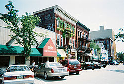 |
Roughly bounded by Tunnel Street, Main Street, Third Street and Harrison Avenue 40°18′11"N 79°32′42"W |
Greensburg Greensburg, Pennsylvania Greensburg is a city in Westmoreland County, Pennsylvania, United States, and a part of the Pittsburgh Metro Area. The city is named after Nathanael Greene, a major general of the Continental Army in the American Revolutionary War... |
||
| 17 | Greensburg Railroad Station Greensburg (Amtrak station) Greensburg Station is an Amtrak railway station located approximately east of Pittsburgh at Harrison Avenue and Seton Hill Drive in Greensburg, Pennsylvania. The station is located just north of the city center, and is currently served only by Amtrak's Pennsylvanian, which operates once per day in... |
Harrison Avenue 40°18′16"N 79°32′49"W |
Greensburg Greensburg, Pennsylvania Greensburg is a city in Westmoreland County, Pennsylvania, United States, and a part of the Pittsburgh Metro Area. The city is named after Nathanael Greene, a major general of the Continental Army in the American Revolutionary War... |
|||
| 18 | Hannastown Farm | Northwest of the junction of Township 825 and Legislative Route 64054 40°21′11"N 79°30′21"W |
Salem Township Salem Township, Westmoreland County, Pennsylvania Salem Township is a township in Westmoreland County, Pennsylvania, United States. The population was 6,939 at the 2000 census.-Geography:According to the United States Census Bureau, the township has a total area of 47.8 square miles , of which, 47.1 square miles of it is land and... |
|||
| 19 | Household No. 1 Site (36WM61) Household No. 1 Site The Household No. 1 Site is an archaeological site in Westmoreland County, Pennsylvania, United States. Located off Timms Lane in Rostraver Township, the site lies on a bluff above the Youghiogheny River.... |
Off Timms Lane 40°10′27.7"N 79°46′44.4"W |
Rostraver Township | |||
| 20 | Kingston House | U.S. Route 30 U.S. Route 30 U.S. Route 30 is an east–west main route of the system of United States Numbered Highways, with the highway traveling across the northern tier of the country. It is the third longest U.S. route, after U.S. Route 20 and U.S. Route 6. The western end of the highway is at Astoria, Oregon; the... , northeast of Youngstown 40°17′28"N 79°20′29"W |
Unity Township | |||
| 21 | Latrobe Armory | 1017 Ridge Avenue 40°19′0"N 79°22′53"W |
Latrobe Latrobe, Pennsylvania Latrobe is a city in Westmoreland County, Pennsylvania in the United States, approximately southeast of Pittsburgh.The city population was 7,634 as of the 2000 census . It is located near the Pennsylvania's scenic Chestnut Ridge. Latrobe was incorporated as a borough in 1854, and as a city in 1999... |
|||
| 22 | Laurel Hill Furnace | Southeast of New Florence on Baldwin Run 40°22′0"N 79°3′32"W |
St. Clair Township | |||
| 23 | Ligonier Armory | 358 West Main Street 40°14′49"N 79°14′33"W |
Ligonier Ligonier, Pennsylvania Ligonier is a borough in Westmoreland County, Pennsylvania, United States. The population was 1,695 at the 2000 census. Ligonier was settled in the 1760s. The borough is well known for nearby Idlewild Park, one of the oldest amusement parks in the country, and nearby Seven Springs Mountain Resort... |
Demolished. | ||
| 24 | Ligonier Historic District | 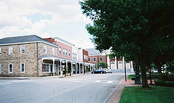 |
Junction of Main and Market Streets 40°14′35"N 79°14′16"W |
Ligonier Ligonier, Pennsylvania Ligonier is a borough in Westmoreland County, Pennsylvania, United States. The population was 1,695 at the 2000 census. Ligonier was settled in the 1760s. The borough is well known for nearby Idlewild Park, one of the oldest amusement parks in the country, and nearby Seven Springs Mountain Resort... |
||
| 25 | Linn Run State Park Family Cabin District Linn Run State Park Linn Run State Park is a Pennsylvania state park on in Cook and Ligonier Townships, Westmoreland County, Pennsylvania in the United States. The park borders Forbes State Forest. Two smaller streams, Grove Run and Rock Run, join in Linn Run State Park to form Linn Run which has a waterfall, Adams... |
2 miles (3.2 km) southeast of Rector on Linn Run Road 40°9′14"N 79°13′0"W |
Cook Township | |||
| 26 | Andrew and Jennie McFarlane House | 50 Maus Drive, west of Irwin 40°19′47"N 79°44′21"W |
North Huntingdon Township North Huntingdon Township, Westmoreland County, Pennsylvania North Huntingdon Township is a township in Westmoreland County, Pennsylvania, USA. The population was 30,609 at the 2010 census.-History:Named after England’s Earl of Huntingdon, Huntingdon Township was founded on April 6, 1772 in Pennsylvania.... |
|||
| 27 | Mount Pleasant Armory | Eagle and Spring Streets 40°8′59"N 79°32′54"W |
Mount Pleasant Mount Pleasant, Pennsylvania Mount Pleasant is a borough in Westmoreland County, Pennsylvania, in the United States. It stands 45 miles southeast of Pittsburgh. Population in 1900, 4,745 people; in 1910, 5,812 people; and in 1940, 5,824 people... |
Demolished in 1996 | ||
| 28 | Mount Pleasant Historic District | Roughly along Main, South Church, Eagle, Walnut and College Streets 40°8′54"N 79°32′41"W |
Mount Pleasant Mount Pleasant, Pennsylvania Mount Pleasant is a borough in Westmoreland County, Pennsylvania, in the United States. It stands 45 miles southeast of Pittsburgh. Population in 1900, 4,745 people; in 1910, 5,812 people; and in 1940, 5,824 people... |
|||
| 29 | Mount St. Peter Roman Catholic Church Mount St. Peter Church Mount Saint Peter Church is a Roman Catholic Church at 100 Freeport Road in New Kensington, Pennsylvania. The church is located along the Allegheny River and is approximately north-east of the city of Pittsburgh... |
100 Freeport Road 40°33′50"N 79°45′42"W |
New Kensington New Kensington, Pennsylvania New Kensington is a city in Westmoreland County, Pennsylvania situated along the Allegheny River northeast of Pittsburgh. The population was 14,701 at the 2000 Census. The mayor of New Kensington is Tom Guzzo , elected in 2009. He succeeded Mayor Frank E. Link , elected in 2001.-History:New... |
|||
| 30 | New Kensington Downtown Historic District | Roughly bounded by 8th Avenue, 3rd Street, 11th Avenue, and Barnes Avenue 40°33′58"N 79°45′58"W |
New Kensington New Kensington, Pennsylvania New Kensington is a city in Westmoreland County, Pennsylvania situated along the Allegheny River northeast of Pittsburgh. The population was 14,701 at the 2000 Census. The mayor of New Kensington is Tom Guzzo , elected in 2009. He succeeded Mayor Frank E. Link , elected in 2001.-History:New... |
|||
| 31 | New Kensington Production Works Historic District | Roughly along the Allegheny River Allegheny River The Allegheny River is a principal tributary of the Ohio River; it is located in the Eastern United States. The Allegheny River joins with the Monongahela River to form the Ohio River at the "Point" of Point State Park in Downtown Pittsburgh, Pennsylvania... , from Sixteenth Street to Seventh Street 40°33′56"N 79°46′13"W |
New Kensington New Kensington, Pennsylvania New Kensington is a city in Westmoreland County, Pennsylvania situated along the Allegheny River northeast of Pittsburgh. The population was 14,701 at the 2000 Census. The mayor of New Kensington is Tom Guzzo , elected in 2009. He succeeded Mayor Frank E. Link , elected in 2001.-History:New... |
|||
| 32 | Samuel Patterson House | Pennsylvania Route 981 Pennsylvania Route 981 Pennsylvania Route 981 is a state highway which runs across Westmoreland County, in southwestern Pennsylvania. The highway begins at Pennsylvania Route 51 in Rostraver Township, Pennsylvania, and runs northward across Westmoreland County, passing through the towns of Mount Pleasant, Latrobe, and... , north of New Alexandria 40°23′58"N 79°25′20"W |
Derry Township Derry Township, Westmoreland County, Pennsylvania Derry Township is a township in Westmoreland County, Pennsylvania, in the United States. It surrounds the Borough of Derry, which is a separate municipality... |
|||
| 33 | Pennsylvania Railroad Station-Latrobe Latrobe (Amtrak station) Latrobe Station is an Amtrak rail station located about 40 miles east of Pittsburgh at 329 McKinley Avenue, Latrobe, Pennsylvania. The station is near the center of the city, and is currently served only by Amtrak's Pennsylvanian, which operates once per day in each direction... |
 |
Depot Street 40°19′7"N 79°23′8"W |
Latrobe Latrobe, Pennsylvania Latrobe is a city in Westmoreland County, Pennsylvania in the United States, approximately southeast of Pittsburgh.The city population was 7,634 as of the 2000 census . It is located near the Pennsylvania's scenic Chestnut Ridge. Latrobe was incorporated as a borough in 1854, and as a city in 1999... |
||
| 34 | Plumer House | Vine and South Water Street 40°12′33"N 79°46′10"W |
West Newton West Newton, Pennsylvania West Newton, located southeast of Pittsburgh, is a borough in Westmoreland County in the U.S. state of Pennsylvania. Formerly, the manufacture of radiators and boilers were the chief industries. In 1900, the people living there numbered 2,467. In 1910, 2,880 people lived there... |
|||
| 35 | Ross Furnace | Southwest of Tubmill Reservoir off Pennsylvania Route 711 Pennsylvania Route 711 Pennsylvania Route 711 is an long, north–south state highway located in Fayette, Westmoreland and Indiana counties in Pennsylvania. The southern terminus is at US 119/PA 201 in Connellsville. The northern terminus is at PA 403 in East Wheatfield Township.-Route description:PA 711 goes by... 40°19′33"N 79°5′26"W |
Fairfield Township Fairfield Township, Westmoreland County, Pennsylvania Fairfield Township is a township in Westmoreland County, Pennsylvania, United States. The population was 2,536 at the 2000 census.-Geography:... |
|||
| 36 | St. Gertrude Roman Catholic Church St. Gertrude Roman Catholic Church St. Gertrude Roman Catholic Church is a historic church at 311 Franklin Avenue in Vandergrift, Pennsylvania.It was built in 1911 and added to the National Register in 1983.-References:... |
311 Franklin Avenue 40°36′10"N 79°34′7"W |
Vandergrift Vandergrift, Pennsylvania Mosher shows how Vandergrift was representative of the new industrial suburbs of Pittsburgh. Caught up in a dramatic round of industrial restructuring and labor tension, Pittsburgh steelmaker George McMurtry hired Frederick Law Olmsted's landscape architectural firm in 1895 to design Vandergrift... |
|||
| 37 | St. Vincent Archabbey Gristmill | Southwest of Latrobe off U.S. Route 30 U.S. Route 30 U.S. Route 30 is an east–west main route of the system of United States Numbered Highways, with the highway traveling across the northern tier of the country. It is the third longest U.S. route, after U.S. Route 20 and U.S. Route 6. The western end of the highway is at Astoria, Oregon; the... 40°17′43"N 79°24′10"W |
Unity Township | |||
| 38 | Salem Crossroads Historic District | Pittsburgh and Greensburg Streets 40°24′44"N 79°34′10"W |
Delmont Delmont, Pennsylvania Delmont is a borough in Westmoreland County, Pennsylvania, United States. The population was 2,497 at the 2000 census.-Geography:Delmont is located at .... |
|||
| 39 | Scottdale Armory | 501 North Broadway Street 40°6′17"N 79°35′8"W |
Scottdale Scottdale, Pennsylvania Scottdale is a borough in Westmoreland County, Pennsylvania, southeast of Pittsburgh. Scottdale is the home of the Southmoreland Scotties. Early in the 20th century, Scottdale was the center of the Frick coke interests... |
|||
| 40 | Scottdale Historic District | Roughly bounded by Walnut Street, Constitution Way, Arthur Avenue and Jacob's Creek Jacob's Creek Jacobs Creek is a small creek that runs through the wine-producing region of the Barossa Valley, 80 km north of Adelaide, South Australia. The creek itself is only several kilometres long and flows westwards from its beginning in the Barossa Ranges, eventually meeting the North Para River... 40°6′5"N 79°35′22"W |
Scottdale Scottdale, Pennsylvania Scottdale is a borough in Westmoreland County, Pennsylvania, southeast of Pittsburgh. Scottdale is the home of the Southmoreland Scotties. Early in the 20th century, Scottdale was the center of the Frick coke interests... |
|||
| 41 | Sewickley Manor | Legislative Route 64136, north of Calumet 40°14′5"N 79°28′56"W |
Mount Pleasant Township Mount Pleasant Township, Westmoreland County, Pennsylvania Mount Pleasant Township is a township in Westmoreland County, Pennsylvania, in the United States. As of the 2000 census, the township population was 11,153... |
|||
| 42 | Site of Old Hannastown | 4 miles (6.4 km) northeast of Greensburg 40°20′37"N 79°30′19"W |
Hempfield Township Hempfield Township, Westmoreland County, Pennsylvania Hempfield Township is a township in Westmoreland County, Pennsylvania, United States. The population was 43,241 at the 2010 census, making it the largest suburb in the Pittsburgh Metropolitan Area by population.- Geography :... |
|||
| 43 | Slickville Historic District | Roughly bounded by Greenburg and Second Avenue and Delmont, Court, Cottage and Fred Streets, in Slickville 40°27′27"N 79°31′23"W |
Salem Township Salem Township, Westmoreland County, Pennsylvania Salem Township is a township in Westmoreland County, Pennsylvania, United States. The population was 6,939 at the 2000 census.-Geography:According to the United States Census Bureau, the township has a total area of 47.8 square miles , of which, 47.1 square miles of it is land and... |
|||
| 44 | Squirrel Hill Site Squirrel Hill Site The Squirrel Hill Site is an archaeological site in northeastern Westmoreland County, Pennsylvania, United States. Located in St. Clair Township west of the borough of New Florence, it was once occupied by a large Monongahela village during the pre-contact period.The village site lies on a bluff... |
West of New Florence near the banks of the Conemaugh River Conemaugh River The Conemaugh River is a long tributary of the Kiskiminetas River in Westmoreland, Indiana, and Cambria counties in the U.S. state of Pennsylvania.- Course :... 40°22′49.05"N 79°5′20.28"W |
St. Clair Township | |||
| 45 | Vandergrift Historic District | Roughly bounded by Lincoln, Sherman, Franklin and Washington Avenues, along the outer lot lines 40°36′9"N 79°33′44"W |
Vandergrift Vandergrift, Pennsylvania Mosher shows how Vandergrift was representative of the new industrial suburbs of Pittsburgh. Caught up in a dramatic round of industrial restructuring and labor tension, Pittsburgh steelmaker George McMurtry hired Frederick Law Olmsted's landscape architectural firm in 1895 to design Vandergrift... |
|||
| 46 | John Walter Farmstead | 166 Mamont Drive 40°32′52"N 79°35′21"W |
Washington Township Washington Township, Westmoreland County, Pennsylvania Washington Township is a township in Westmoreland County, Pennsylvania, United States. It was founded in 1789 from Salem Township. At that time it included the present-day municipalities of Allegheny, Lower Burrell, Upper Burrell, and most of Bell... |
|||
| 47 | Samuel Warden House | 200 South Church Street 40°8′52"N 79°32′50"W |
Mount Pleasant Mount Pleasant, Pennsylvania Mount Pleasant is a borough in Westmoreland County, Pennsylvania, in the United States. It stands 45 miles southeast of Pittsburgh. Population in 1900, 4,745 people; in 1910, 5,812 people; and in 1940, 5,824 people... |
|||
| 48 | Webster Donora Bridge | Pennsylvania Route 143 Pennsylvania Route 143 Pennsylvania Route 143 is a long state highway in Pennsylvania. It runs from Pennsylvania Route 309 near New Tripoli to Pennsylvania Route 662 in Richmond Township just east of the town of Shoemakersville.... over the Monongahela River Monongahela River The Monongahela River is a river on the Allegheny Plateau in north-central West Virginia and southwestern Pennsylvania in the United States... at Webster 40°11′3"N 79°51′8"W |
Rostraver Township | Extends into Washington County | ||
| 49 | West Overton Historic District | Frick Avenue 40°6′59"N 79°33′59"W |
East Huntingdon Township | |||
| 50 | Western Division of the PA Canal | Along the Conemaugh River Conemaugh River The Conemaugh River is a long tributary of the Kiskiminetas River in Westmoreland, Indiana, and Cambria counties in the U.S. state of Pennsylvania.- Course :... 40°25′31"N 79°13′48"W |
Bolivar Bolivar, Pennsylvania Bolivar is a borough in Westmoreland County, Pennsylvania, United States. The population was 501 at the 2000 census.-Geography:Bolivar is located at .... , Derry Township Derry Township, Westmoreland County, Pennsylvania Derry Township is a township in Westmoreland County, Pennsylvania, in the United States. It surrounds the Borough of Derry, which is a separate municipality... , and Fairfield Township Fairfield Township, Westmoreland County, Pennsylvania Fairfield Township is a township in Westmoreland County, Pennsylvania, United States. The population was 2,536 at the 2000 census.-Geography:... |
|||
| 51 | Western Division-Pennsylvania Canal | Along the Conemaugh River Conemaugh River The Conemaugh River is a long tributary of the Kiskiminetas River in Westmoreland, Indiana, and Cambria counties in the U.S. state of Pennsylvania.- Course :... 40°25′30"N 79°13′48"W |
Bell Bell Township, Westmoreland County, Pennsylvania Bell Township is a township in Westmoreland County, Pennsylvania, United States. The population was 2,458 at the 2000 census.-Geography:According to the United States Census Bureau, the township has a total area of , of which, of it is land and of it is water.-Demographics:As of the census of... , Derry Derry Township, Westmoreland County, Pennsylvania Derry Township is a township in Westmoreland County, Pennsylvania, in the United States. It surrounds the Borough of Derry, which is a separate municipality... , and Loyalhanna Townships |
|||
| 52 | Westmoreland County Courthouse Westmoreland County Courthouse The Westmoreland County Courthouse is a government building of Westmoreland County located in the county seat, Greensburg, Pennsylvania. It is a contributing property to the Downtown Greensburg Historic District, but was listed separately on the National Register of Historic Places on March 30, 1978... |
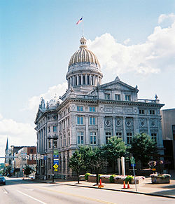 |
North Main Street 40°18′9"N 79°32′46"W |
Greensburg Greensburg, Pennsylvania Greensburg is a city in Westmoreland County, Pennsylvania, United States, and a part of the Pittsburgh Metro Area. The city is named after Nathanael Greene, a major general of the Continental Army in the American Revolutionary War... |
Former listing
| Landmark name | Image | Date delisted | Location | City or Town | Summary | |
|---|---|---|---|---|---|---|
| 1 | Gen. Greene Hotel | 24 West Otterman Street | Greensburg Greensburg, Pennsylvania Greensburg is a city in Westmoreland County, Pennsylvania, United States, and a part of the Pittsburgh Metro Area. The city is named after Nathanael Greene, a major general of the Continental Army in the American Revolutionary War... |
Built 1903 demolished |
See also
- List of National Historic Landmarks in Pennsylvania
- National Register of Historic Places listings in Pennsylvania
- List of Pennsylvania state historical markers in Westmoreland County