
Pennsylvania Route 981
Encyclopedia
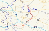
Pennsylvania Route 981 is a state highway
which runs 50.4 miles (81.1 km) across Westmoreland County
, in southwestern Pennsylvania
. The highway begins at Pennsylvania Route 51
in Rostraver Township, Pennsylvania
, and runs northward across Westmoreland County, passing through the towns of Mount Pleasant
, Latrobe
, and New Alexandria
before ending at Pennsylvania Route 819
in Salina
.
in Rostraver Township
. From Rostraver, the route runs eastward to Mount Pleasant
, where it meets Pennsylvania Route 31
. Route 981 then turns northward, meeting U.S. Route 30
outside Latrobe
, near the Arnold Palmer Regional Airport
. The route then continues northward through Latrobe, passing by Saint Vincent College
in Latrobe. Continuing northward, Route 981 meets U.S. Route 119
and U.S. Route 22
at New Alexandria, Pennsylvania
. The route then ends at Pennsylvania Route 819
near Salina
.
, but was extended in 1998 to its current terminus at Pennsylvania Route 819
.
near Latrobe
.
.
State highway
State highway, state road or state route can refer to one of three related concepts, two of them related to a state or provincial government in a country that is divided into states or provinces :#A...
which runs 50.4 miles (81.1 km) across Westmoreland County
Westmoreland County, Pennsylvania
-Demographics:As of the census of 2000, there were 369,993 people, 149,813 households, and 104,569 families residing in the county. The population density was 361 people per square mile . There were 161,058 housing units at an average density of 157 per square mile...
, in southwestern Pennsylvania
Pennsylvania
The Commonwealth of Pennsylvania is a U.S. state that is located in the Northeastern and Mid-Atlantic regions of the United States. The state borders Delaware and Maryland to the south, West Virginia to the southwest, Ohio to the west, New York and Ontario, Canada, to the north, and New Jersey to...
. The highway begins at Pennsylvania Route 51
Pennsylvania Route 51
Pennsylvania Route 51 is a major state highway in Western Pennsylvania. It runs for from Uniontown to the Ohio state line near Darlington, where it connects with Ohio State Route 14. Route 51 is the termination point for Pennsylvania Route 43, Pennsylvania Route 48 and Pennsylvania Route 88. ...
in Rostraver Township, Pennsylvania
Rostraver Township, Pennsylvania
Rostraver Township is a township in Westmoreland County, Pennsylvania, United States. The population was 11,634 at the 2000 census.-History:Rostraver Township is the location of the Household No. 1 Site, which was once occupied by a Monongahela village....
, and runs northward across Westmoreland County, passing through the towns of Mount Pleasant
Mount Pleasant, Pennsylvania
Mount Pleasant is a borough in Westmoreland County, Pennsylvania, in the United States. It stands 45 miles southeast of Pittsburgh. Population in 1900, 4,745 people; in 1910, 5,812 people; and in 1940, 5,824 people...
, Latrobe
Latrobe, Pennsylvania
Latrobe is a city in Westmoreland County, Pennsylvania in the United States, approximately southeast of Pittsburgh.The city population was 7,634 as of the 2000 census . It is located near the Pennsylvania's scenic Chestnut Ridge. Latrobe was incorporated as a borough in 1854, and as a city in 1999...
, and New Alexandria
New Alexandria, Pennsylvania
New Alexandria is a borough in Westmoreland County, Pennsylvania, United States. The population was 595 at the 2000 census.-Geography:New Alexandria is located at ....
before ending at Pennsylvania Route 819
Pennsylvania Route 819
Pennsylvania Route 819 is a long state highway located in Fayette and Westmoreland counties in Pennsylvania, USA. The southern terminus is at PA 201 in Vanderbilt. The northern terminus is at PA 66 in Oklahoma.-Fayette County:...
in Salina
Salina, Pennsylvania
Salina is an unincorporated community in northern Westmoreland County, Pennsylvania, United States. Located near Route 819, it lies near communities such as Tinsmill and Avonmore. Salina also is located near Kiski Area School District's Elementary School, Bell-Avon. Salina was also once a salt...
.
Route description
Pennsylvania Route 981 begins at Pennsylvania Route 51Pennsylvania Route 51
Pennsylvania Route 51 is a major state highway in Western Pennsylvania. It runs for from Uniontown to the Ohio state line near Darlington, where it connects with Ohio State Route 14. Route 51 is the termination point for Pennsylvania Route 43, Pennsylvania Route 48 and Pennsylvania Route 88. ...
in Rostraver Township
Rostraver Township, Pennsylvania
Rostraver Township is a township in Westmoreland County, Pennsylvania, United States. The population was 11,634 at the 2000 census.-History:Rostraver Township is the location of the Household No. 1 Site, which was once occupied by a Monongahela village....
. From Rostraver, the route runs eastward to Mount Pleasant
Mount Pleasant, Pennsylvania
Mount Pleasant is a borough in Westmoreland County, Pennsylvania, in the United States. It stands 45 miles southeast of Pittsburgh. Population in 1900, 4,745 people; in 1910, 5,812 people; and in 1940, 5,824 people...
, where it meets Pennsylvania Route 31
Pennsylvania Route 31
Pennsylvania Route 31 is a long state highway located in Western Pennsylvania, paralleling U.S. Route 30 and the Pennsylvania Turnpike for most of its length. The designation begins at PA 136 near West Newton and ends at US 30 near Bedford....
. Route 981 then turns northward, meeting U.S. Route 30
U.S. Route 30
U.S. Route 30 is an east–west main route of the system of United States Numbered Highways, with the highway traveling across the northern tier of the country. It is the third longest U.S. route, after U.S. Route 20 and U.S. Route 6. The western end of the highway is at Astoria, Oregon; the...
outside Latrobe
Latrobe, Pennsylvania
Latrobe is a city in Westmoreland County, Pennsylvania in the United States, approximately southeast of Pittsburgh.The city population was 7,634 as of the 2000 census . It is located near the Pennsylvania's scenic Chestnut Ridge. Latrobe was incorporated as a borough in 1854, and as a city in 1999...
, near the Arnold Palmer Regional Airport
Arnold Palmer Regional Airport
Arnold Palmer Regional Airport is a public use airport located two nautical miles southwest of the central business district of Latrobe, and approximately 29 nautical miles southeast of Pittsburgh, in Westmoreland County, Pennsylvania, United States. It is owned by the Westmoreland County...
. The route then continues northward through Latrobe, passing by Saint Vincent College
Saint Vincent College
Saint Vincent College is a four-year, coeducational, Roman Catholic, Benedictine, liberal arts college in Latrobe, Pennsylvania, located about 40 miles southeast of Pittsburgh. It was founded in 1846 by Boniface Wimmer, a monk from Bavaria, Germany. It was the first Benedictine monastery in the...
in Latrobe. Continuing northward, Route 981 meets U.S. Route 119
U.S. Route 119
U.S. Route 119, commonly abbreviated as US 119, is a spur of US 19. It is a north–south route that was an original United States highway of 1926. It is often referred to as Corridor G east of US 23 and KY 80 in Kentucky to Interstate 64 at Charleston, West Virginia.- Kentucky :US 119 is a two...
and U.S. Route 22
U.S. Route 22
U.S. Route 22 is a west–east route and is one of the original United States highways of 1926, running from Cincinnati, Ohio, at US 27, US 42, US 127, and US 52 to Newark, New Jersey, at U.S. Route 1/9 near the Newark Liberty International Airport.US 22 also carries the names of the William...
at New Alexandria, Pennsylvania
New Alexandria, Pennsylvania
New Alexandria is a borough in Westmoreland County, Pennsylvania, United States. The population was 595 at the 2000 census.-Geography:New Alexandria is located at ....
. The route then ends at Pennsylvania Route 819
Pennsylvania Route 819
Pennsylvania Route 819 is a long state highway located in Fayette and Westmoreland counties in Pennsylvania, USA. The southern terminus is at PA 201 in Vanderbilt. The northern terminus is at PA 66 in Oklahoma.-Fayette County:...
near Salina
Salina, Pennsylvania
Salina is an unincorporated community in northern Westmoreland County, Pennsylvania, United States. Located near Route 819, it lies near communities such as Tinsmill and Avonmore. Salina also is located near Kiski Area School District's Elementary School, Bell-Avon. Salina was also once a salt...
.
History
Pennsylvania Route 981 previously ended at Pennsylvania Route 156Pennsylvania Route 156
Pennsylvania Route 156 is a long state highway located in Westmoreland, Armstrong and Indiana counties in Pennsylvania. The southern terminus is at PA 981 in Avonmore, PA...
, but was extended in 1998 to its current terminus at Pennsylvania Route 819
Pennsylvania Route 819
Pennsylvania Route 819 is a long state highway located in Fayette and Westmoreland counties in Pennsylvania, USA. The southern terminus is at PA 201 in Vanderbilt. The northern terminus is at PA 66 in Oklahoma.-Fayette County:...
.
Future
PennDOT began construction in 2006 to improve the intersection between Pennsylvania Route 981 and U.S. Route 30U.S. Route 30
U.S. Route 30 is an east–west main route of the system of United States Numbered Highways, with the highway traveling across the northern tier of the country. It is the third longest U.S. route, after U.S. Route 20 and U.S. Route 6. The western end of the highway is at Astoria, Oregon; the...
near Latrobe
Latrobe, Pennsylvania
Latrobe is a city in Westmoreland County, Pennsylvania in the United States, approximately southeast of Pittsburgh.The city population was 7,634 as of the 2000 census . It is located near the Pennsylvania's scenic Chestnut Ridge. Latrobe was incorporated as a borough in 1854, and as a city in 1999...
.
Major intersections
The entire route is in Westmoreland CountyWestmoreland County, Pennsylvania
-Demographics:As of the census of 2000, there were 369,993 people, 149,813 households, and 104,569 families residing in the county. The population density was 361 people per square mile . There were 161,058 housing units at an average density of 157 per square mile...
.
| Mile | Destinations | Notes |
|---|---|---|
| 0.0 |  PA 51 PA 51Pennsylvania Route 51 Pennsylvania Route 51 is a major state highway in Western Pennsylvania. It runs for from Uniontown to the Ohio state line near Darlington, where it connects with Ohio State Route 14. Route 51 is the termination point for Pennsylvania Route 43, Pennsylvania Route 48 and Pennsylvania Route 88. ... |
PA 981 begins |
| 4.6 | Pennsylvania Route 3035 | |
| 7.0 | Pennsylvania Route 3037 | |
| 8.3 | Pennsylvania Route 3073 | |
| 13.8 | To | Access to I-70/I-76 via US 119. |
| 15.3 |  PA 819 PA 819Pennsylvania Route 819 Pennsylvania Route 819 is a long state highway located in Fayette and Westmoreland counties in Pennsylvania, USA. The southern terminus is at PA 201 in Vanderbilt. The northern terminus is at PA 66 in Oklahoma.-Fayette County:... |
|
| 23.0 |  PA-130 PA-130Pennsylvania Route 130 Pennsylvania Route 130 is a long state highway located in Allegheny and Westmoreland counties in Pennsylvania. The western terminus is at PA 8 in Pittsburgh. The eastern terminus is at PA 381 near Kregar.... |
|
| 27.4 |  US 30 US 30 |
|
| 35.3 | Slag Road | Access to Keystone State Park |
| 38.1 |   US 22/US 119 US 22/US 119 |
|
| 45.8,46.0 |    PA 286 PA 286Pennsylvania Route 286 Pennsylvania Route 286 is an long, east–west state highway located in Allegheny, Westmoreland, Indiana, and Clearfield counties in Pennsylvania. The western terminus is at US 22 in Monroeville. The eastern terminus is at US 219 near Burnside.... /To PA 380 Pennsylvania Route 380 Pennsylvania Route 380 , also known as J.F. Bonetto Memorial Highway, is a long state highway in western portions of the U.S. state of Pennsylvania. The western terminus of the route is at Interstate 579 in downtown Pittsburgh near Mellon Arena... |
|
| 48.5 |  PA 156 PA 156Pennsylvania Route 156 Pennsylvania Route 156 is a long state highway located in Westmoreland, Armstrong and Indiana counties in Pennsylvania. The southern terminus is at PA 981 in Avonmore, PA... |
|
| 50.4 | PA 819 Pennsylvania Route 819 Pennsylvania Route 819 is a long state highway located in Fayette and Westmoreland counties in Pennsylvania, USA. The southern terminus is at PA 201 in Vanderbilt. The northern terminus is at PA 66 in Oklahoma.-Fayette County:... |
PA 981 ends |