
Ligonier, Pennsylvania
Encyclopedia
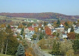
Ligonier is a borough in Westmoreland County
, Pennsylvania
, United States
. The population was 1,695 at the 2000 census. Ligonier was settled in the 1760s. The borough is well known for nearby Idlewild Park, one of the oldest amusement park
s in the country, and nearby Seven Springs Mountain Resort
. Another tourist attraction is Fort Ligonier Days, a parade and craft market that takes place every fall over the course of three days. Ligonier is part of the Pittsburgh Metropolitan Statistical Area.
Ligonier is the site of a reconstruction of Fort Ligonier
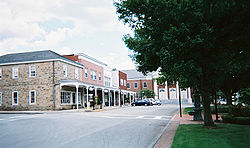
, an example of a frontier fort of the French and Indian War. Ligonier is also known for its downtown square, the Diamond, which has a bandstand
in the middle.
, which is a separate municipality. According to the United States Census Bureau
, the borough has a total area of 0.5 square miles (1.3 km²), all of it land. Ligonier is located at 40°15′N 79°14′W (40.2445, -79.2371).
forces from the forks of the Ohio
, now Pittsburgh, this spot on Loyalhanna Creek
was the site of their westernmost camp before reaching the Ohio. It was an enormous army, a virtual moving city of 6,000 people, that temporarily made this the most populated spot in Pennsylvania second only to Philadelphia. The fort was named Fort Ligonier after John Ligonier, a British
noble of French origin who held the rank of Field Marshal
in the British Army
. Eventually, the name of the settlement that grew up around the fort was shortened to Ligonier.
In 1817, the Philadelphia-Pittsburgh Turnpike was completed, a gravel road that was the precursor to today's US Route 30. Fort Ligonier was a logical place for travelers to break their journey, and with such commercial opportunities in mind, a local resident named John Ramsay (sometimes spelled Ramsey) laid out the street plan, including the space now known as the Diamond. He initially called the town Ramseytown, later changed to Wellington (after the Duke of Wellington
), and finally the name was changed to Ligonier. Several decades of prosperity followed. On April 10, 1834, Ligonier was incorporated as a borough.
However, in 1852 the Pennsylvania Railroad
was completed, which avoided Ligonier and passed through Bolivar
and Latrobe
instead. Traffic shifted from horse-drawn vehicles to the railroad, causing the community's population to drop to 350 according to the 1860 census. A quarter-century of stagnation ensued as the town withered.
Ligonier enjoyed a new impetus when the Ligonier Valley Railroad
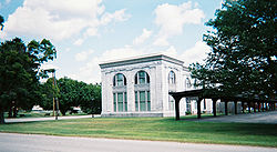
was completed in 1877, linking the community to Latrobe where connections to the Pennsylvania Railroad were possible. The Ligonier Valley Railroad enabled lumber, coal, and quarried stone to be transported out of the Ligonier Valley, which spurred development of the town. Also, the railroad made it easier for Pittsbugh residents to visit Ligonier, causing the town to develop as a summer resort. Some major physical changes to Ligonier occurred during this period. In 1894, the Diamond, which had been used as a corral for horses and wagons, was transformed into a park with a bandstand. A large hotel, the Hotel Breniser, was built in 1900 where the town hall currently sits. In 1909-1910, the Ligonier Valley Railroad built an ornate station and headquarters building, which still stands at 339 West Main Street.
 In 1952, the Ligonier Valley Railroad ceased operation, due to a combination of overlogging, decline of the coal industry, and the loss of passenger traffic to motor vehicles.
The Pittsburgh, Westmoreland and Somerset Railroad
also served Ligonier from 1899 to 1916, although it did not enjoy the success of the Ligonier Valley Railroad.
Ligonier has two sites on the National Register of Historic Places
: Fort Ligonier
at 216 South Market Street and the Ligonier Historic District, which encompasses the Diamond and the oldest parts of the borough.
Ligonier and its surrounding countryside are strongly associated with the Mellon banking family, which still owns considerable tracts of land in the area. The Huntland Downs estate, near Ligonier, comprises some 30000 acres (121.4 km²) of land and is the centerpiece of the Mellon land holdings in the region.

of 2000, there are 1,695 people, 827 households, and 459 families residing in the borough. The population density
is 3,482.5 people per square mile (1,335.6/km²). There are 907 housing units at an average density of 1,863.5 per square mile (714.7/km²). The racial makeup of the borough is 99.76% White, 0.06% Asian, and 0.18% from two or more races. 0.35% of the population are Hispanic or Latino of any race.
Westmoreland County, Pennsylvania
-Demographics:As of the census of 2000, there were 369,993 people, 149,813 households, and 104,569 families residing in the county. The population density was 361 people per square mile . There were 161,058 housing units at an average density of 157 per square mile...
, Pennsylvania
Pennsylvania
The Commonwealth of Pennsylvania is a U.S. state that is located in the Northeastern and Mid-Atlantic regions of the United States. The state borders Delaware and Maryland to the south, West Virginia to the southwest, Ohio to the west, New York and Ontario, Canada, to the north, and New Jersey to...
, United States
United States
The United States of America is a federal constitutional republic comprising fifty states and a federal district...
. The population was 1,695 at the 2000 census. Ligonier was settled in the 1760s. The borough is well known for nearby Idlewild Park, one of the oldest amusement park
Amusement park
thumb|Cinderella Castle in [[Magic Kingdom]], [[Disney World]]Amusement and theme parks are terms for a group of entertainment attractions and rides and other events in a location for the enjoyment of large numbers of people...
s in the country, and nearby Seven Springs Mountain Resort
Seven Springs Mountain Resort
Seven Springs Mountain Resort is an all season resort located in Seven Springs, Pennsylvania. The resort is officially listed in the borough of Seven Springs but some sources still list it as Champion, as it previously was. It has a fairly high elevation for a Pennsylvania ski area, at 3001 feet...
. Another tourist attraction is Fort Ligonier Days, a parade and craft market that takes place every fall over the course of three days. Ligonier is part of the Pittsburgh Metropolitan Statistical Area.
Ligonier is the site of a reconstruction of Fort Ligonier
Fort Ligonier
Fort Ligonier is a British fortification from the French and Indian War located in Ligonier, Pennsylvania, United States. The fort served as a staging area for the Forbes Expedition of 1758. During the eight years of its existence as a garrison, Fort Ligonier was never taken by an enemy...
, an example of a frontier fort of the French and Indian War. Ligonier is also known for its downtown square, the Diamond, which has a bandstand
Bandstand
A bandstand is a circular or semicircular structure set in a park, garden, pier, or indoor space, designed to accommodate musical bands performing concerts...
in the middle.
Geography
The Borough of Ligonier is entirely surrounded by Ligonier TownshipLigonier Township, Pennsylvania
Ligonier Township is a township in Westmoreland County, Pennsylvania, United States. Ligonier Township entirely surrounds, but does not include, Ligonier Borough, which is a separate municipality...
, which is a separate municipality. According to the United States Census Bureau
United States Census Bureau
The United States Census Bureau is the government agency that is responsible for the United States Census. It also gathers other national demographic and economic data...
, the borough has a total area of 0.5 square miles (1.3 km²), all of it land. Ligonier is located at 40°15′N 79°14′W (40.2445, -79.2371).
History
In 1758, when British forces launched a major campaign to remove FrenchFrance
The French Republic , The French Republic , The French Republic , (commonly known as France , is a unitary semi-presidential republic in Western Europe with several overseas territories and islands located on other continents and in the Indian, Pacific, and Atlantic oceans. Metropolitan France...
forces from the forks of the Ohio
Ohio
Ohio is a Midwestern state in the United States. The 34th largest state by area in the U.S.,it is the 7th‑most populous with over 11.5 million residents, containing several major American cities and seven metropolitan areas with populations of 500,000 or more.The state's capital is Columbus...
, now Pittsburgh, this spot on Loyalhanna Creek
Loyalhanna Creek
Loyalhanna Creek is a long tributary of the Kiskiminetas River in Westmoreland County in the U.S. state of Pennsylvania. The stream is a popular destination for canoeing and recreational trout fishing.- Etymology :...
was the site of their westernmost camp before reaching the Ohio. It was an enormous army, a virtual moving city of 6,000 people, that temporarily made this the most populated spot in Pennsylvania second only to Philadelphia. The fort was named Fort Ligonier after John Ligonier, a British
British people
The British are citizens of the United Kingdom, of the Isle of Man, any of the Channel Islands, or of any of the British overseas territories, and their descendants...
noble of French origin who held the rank of Field Marshal
Field Marshal
Field Marshal is a military rank. Traditionally, it is the highest military rank in an army.-Etymology:The origin of the rank of field marshal dates to the early Middle Ages, originally meaning the keeper of the king's horses , from the time of the early Frankish kings.-Usage and hierarchical...
in the British Army
British Army
The British Army is the land warfare branch of Her Majesty's Armed Forces in the United Kingdom. It came into being with the unification of the Kingdom of England and Scotland into the Kingdom of Great Britain in 1707. The new British Army incorporated Regiments that had already existed in England...
. Eventually, the name of the settlement that grew up around the fort was shortened to Ligonier.
In 1817, the Philadelphia-Pittsburgh Turnpike was completed, a gravel road that was the precursor to today's US Route 30. Fort Ligonier was a logical place for travelers to break their journey, and with such commercial opportunities in mind, a local resident named John Ramsay (sometimes spelled Ramsey) laid out the street plan, including the space now known as the Diamond. He initially called the town Ramseytown, later changed to Wellington (after the Duke of Wellington
Arthur Wellesley, 1st Duke of Wellington
Field Marshal Arthur Wellesley, 1st Duke of Wellington, KG, GCB, GCH, PC, FRS , was an Irish-born British soldier and statesman, and one of the leading military and political figures of the 19th century...
), and finally the name was changed to Ligonier. Several decades of prosperity followed. On April 10, 1834, Ligonier was incorporated as a borough.
However, in 1852 the Pennsylvania Railroad
Pennsylvania Railroad
The Pennsylvania Railroad was an American Class I railroad, founded in 1846. Commonly referred to as the "Pennsy", the PRR was headquartered in Philadelphia, Pennsylvania....
was completed, which avoided Ligonier and passed through Bolivar
Bolivar, Pennsylvania
Bolivar is a borough in Westmoreland County, Pennsylvania, United States. The population was 501 at the 2000 census.-Geography:Bolivar is located at ....
and Latrobe
Latrobe, Pennsylvania
Latrobe is a city in Westmoreland County, Pennsylvania in the United States, approximately southeast of Pittsburgh.The city population was 7,634 as of the 2000 census . It is located near the Pennsylvania's scenic Chestnut Ridge. Latrobe was incorporated as a borough in 1854, and as a city in 1999...
instead. Traffic shifted from horse-drawn vehicles to the railroad, causing the community's population to drop to 350 according to the 1860 census. A quarter-century of stagnation ensued as the town withered.
Ligonier enjoyed a new impetus when the Ligonier Valley Railroad
Ligonier Valley Railroad
The Ligonier Valley Railroad connected the communities of Latrobe and Ligonier, Pennsylvania, approximately apart, between 1877 and 1952. For much of its length, the railroad ran parallel to Loyalhanna Creek in a scenic mountain gorge...
was completed in 1877, linking the community to Latrobe where connections to the Pennsylvania Railroad were possible. The Ligonier Valley Railroad enabled lumber, coal, and quarried stone to be transported out of the Ligonier Valley, which spurred development of the town. Also, the railroad made it easier for Pittsbugh residents to visit Ligonier, causing the town to develop as a summer resort. Some major physical changes to Ligonier occurred during this period. In 1894, the Diamond, which had been used as a corral for horses and wagons, was transformed into a park with a bandstand. A large hotel, the Hotel Breniser, was built in 1900 where the town hall currently sits. In 1909-1910, the Ligonier Valley Railroad built an ornate station and headquarters building, which still stands at 339 West Main Street.
The Pittsburgh, Westmoreland and Somerset Railroad
Pittsburgh, Westmoreland and Somerset Railroad
The Pittsburgh, Westmoreland, & Somerset Railroad was a short-lived railroad that connected the Pennsylvania communities of Ligonier and Somerset, running over a mountain known as Laurel Hill or Laurel Mountain....
also served Ligonier from 1899 to 1916, although it did not enjoy the success of the Ligonier Valley Railroad.
Ligonier has two sites on the National Register of Historic Places
National Register of Historic Places
The National Register of Historic Places is the United States government's official list of districts, sites, buildings, structures, and objects deemed worthy of preservation...
: Fort Ligonier
Fort Ligonier
Fort Ligonier is a British fortification from the French and Indian War located in Ligonier, Pennsylvania, United States. The fort served as a staging area for the Forbes Expedition of 1758. During the eight years of its existence as a garrison, Fort Ligonier was never taken by an enemy...
at 216 South Market Street and the Ligonier Historic District, which encompasses the Diamond and the oldest parts of the borough.
Ligonier and its surrounding countryside are strongly associated with the Mellon banking family, which still owns considerable tracts of land in the area. The Huntland Downs estate, near Ligonier, comprises some 30000 acres (121.4 km²) of land and is the centerpiece of the Mellon land holdings in the region.
Demographics
As of the censusCensus
A census is the procedure of systematically acquiring and recording information about the members of a given population. It is a regularly occurring and official count of a particular population. The term is used mostly in connection with national population and housing censuses; other common...
of 2000, there are 1,695 people, 827 households, and 459 families residing in the borough. The population density
Population density
Population density is a measurement of population per unit area or unit volume. It is frequently applied to living organisms, and particularly to humans...
is 3,482.5 people per square mile (1,335.6/km²). There are 907 housing units at an average density of 1,863.5 per square mile (714.7/km²). The racial makeup of the borough is 99.76% White, 0.06% Asian, and 0.18% from two or more races. 0.35% of the population are Hispanic or Latino of any race.