

National Register of Historic Places, Knox County, Tennessee
Encyclopedia

This is intended to be a complete list of the properties and districts on the National Register of Historic Places
National Register of Historic Places
The National Register of Historic Places is the United States government's official list of districts, sites, buildings, structures, and objects deemed worthy of preservation...
in Knox County
Knox County, Tennessee
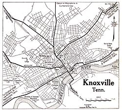
Knox County is a county in the U.S. state of Tennessee. Its 2007 population was estimated at 423,874 by the United States Census Bureau. Its county seat is Knoxville, as it has been since the creation of the county. The county is at the geographical center of the Great Valley of East Tennessee...
, Tennessee
Tennessee
Tennessee is a U.S. state located in the Southeastern United States. It has a population of 6,346,105, making it the nation's 17th-largest state by population, and covers , making it the 36th-largest by total land area...
, United States
United States
The United States of America is a federal constitutional republic comprising fifty states and a federal district...
. Latitude and longitude coordinates are provided for many National Register properties and districts; these locations may be seen together in a Google map.
There are 102 properties and districts listed on the National Register in the county, including 1 National Historic Landmark
National Historic Landmark
A National Historic Landmark is a building, site, structure, object, or district, that is officially recognized by the United States government for its historical significance...
.
History
The earliest settlers in what is now Knox County were Native Americans - the Indian mound is the primary "built structure" that remains from their era. Beginning with explorer Hernando de SotoHernando de Soto (explorer)
Hernando de Soto was a Spanish explorer and conquistador who, while leading the first European expedition deep into the territory of the modern-day United States, was the first European documented to have crossed the Mississippi River....
, who traveled near the county, the earliest Europeans were not settlers but explorers and hunters who left no permanent structures. However, when North Carolina
North Carolina
North Carolina is a state located in the southeastern United States. The state borders South Carolina and Georgia to the south, Tennessee to the west and Virginia to the north. North Carolina contains 100 counties. Its capital is Raleigh, and its largest city is Charlotte...
made land available in the Land Grab Act of 1783, early settlers began surveying the region. These men included General James White
James White (general)
James White was an American pioneer and soldier who founded Knoxville, Tennessee, in the early 1790s. Born in Rowan County, North Carolina, White served as a captain in the county's militia during the American Revolutionary War...
, who soon owned the land that became downtown Knoxville, as well as Frances Alexander Ramsey and Alexander McMillan.
James White settled in rural east Knox County on the French Broad River
French Broad River
The French Broad River flows from near the village of Rosman in Transylvania County, North Carolina, into the state of Tennessee. Its confluence with the Holston River at Knoxville is the beginning of the Tennessee River....
in 1785, but constructed a cabin in what is now downtown Knoxville in 1786. General White later requested that his son-in-law, Charles McClung
Charles McClung
Charles McClung was an American pioneer, politician, and surveyor best known for drawing up the original plat of Knoxville, Tennessee, in 1791. While Knoxville has since expanded to many times its original size, the city's downtown area still roughly follows McClung's 1791 grid...
, survey the land around his cabin and lay out sixteen blocks with four lots on each block. After setting aside lots for his residence, a cemetery, college and other functions he deemed necessary, the balance of the lots were sold by lottery on October 3, 1791. In 1792, the community began to take shape: 1) Knox County, Tennessee
Knox County, Tennessee
Knox County is a county in the U.S. state of Tennessee. Its 2007 population was estimated at 423,874 by the United States Census Bureau. Its county seat is Knoxville, as it has been since the creation of the county. The county is at the geographical center of the Great Valley of East Tennessee...
, was split off from Hawkins County, Tennessee
Hawkins County, Tennessee
Hawkins County is a county located in the U.S. state of Tennessee. As of 2010, the population was 56,833. Its county seat is Rogersville, Tennessee's second-oldest town....
; 2) settlers were constructing buildings on lots they received in the lottery; 3) Samuel and Nathan Cowan opened the first store; and 4) the first tavern
Tavern
A tavern is a place of business where people gather to drink alcoholic beverages and be served food, and in some cases, where travelers receive lodging....
was opened by John Chisholm. In 1793, a garrison of soldiers was assigned to protect the settlers.
Other than setting aside land for Blount College (now the University of Tennessee
University of Tennessee
The University of Tennessee is a public land-grant university headquartered at Knoxville, Tennessee, United States...
), the earliest structures were built to accommodate basic frontier needs. These included the fort, residences, churches, taverns (which also served as inns) and a cemetery.
In terms of growth, development of the county was due both to expansion of the early settlement (a) and the development of roads (b), which linked James White's Fort to other parts of the state: (a) The original 16 square blocks was expanded to accommodate growth in the population. Moses White, James White's son, laid out East Knoxville, which was originally a separate city and called Mechanicsburg. Colonel John Williams
John Williams (Tennessee)
John Williams was an American lawyer, soldier, and statesman, operating primarily out of Knoxville, Tennessee, in the first part of the 19th century. He represented Tennessee in the United States Senate from 1815 to 1823, when he lost reelection to Andrew Jackson. Williams also served as colonel...
laid out the west end of the town, which was briefly known as Williamsburg; and (b) Roads were constructed to allow access both to surrounding settlements in rural areas of Knox County, and to allow pioneers to travel from the east coast further west. Settlers typically traveled down from southwest Virginia
Virginia
The Commonwealth of Virginia , is a U.S. state on the Atlantic Coast of the Southern United States. Virginia is nicknamed the "Old Dominion" and sometimes the "Mother of Presidents" after the eight U.S. presidents born there...
through Rogersville, Tennessee
Rogersville, Tennessee
Rogersville is a town in Hawkins County, Tennessee, United States. It was settled in 1775 by the grandparents of Davy Crockett and is the second-oldest town in the state. It is named for its founder, Joseph Rogers....
on the Knoxville Road before arriving at Knoxville. By 1795, what is now Kingston Pike
Kingston Pike, Knoxville
Kingston Pike is a highway in Knox County, Tennessee, USA, that connects Downtown Knoxville with West Knoxville, Farragut, and other communities in the western part of the county. The road follows a merged stretch of U.S. Route 70 and U.S. Route 11...
went from James White's Fort to the western end of the county. Beyond the western end of the county, this route became known as the Nashville Road. By 1807, the Knoxville Gazette reported that 200 settlers a day were passing through the city on their way further west. Further north in Knox County, Adair's Fort, built by John Adair in Fountain City
Fountain City, Tennessee
Fountain City is a neighborhood in northern Knoxville, Tennessee, in the southeastern United States. Although not a census-designated place , the populations of the two zip codes that serve Fountain City— 37918 and 37912— were 36,815 and 18,695, respectively, as of the 2000 U.S. census...
, protected settlers traveling westward on the Emory Road. And by 1792, Alexander Cunningham was operating the first ferry over the Tennessee River
Tennessee River
The Tennessee River is the largest tributary of the Ohio River. It is approximately 652 miles long and is located in the southeastern United States in the Tennessee Valley. The river was once popularly known as the Cherokee River, among other names...
south of Knoxville.
Despite ceasing to be Tennessee's state capital circa 1816, Knoxville continued to grow slowly through the ante-bellum period. And due to the mountainous terrain, slavery never took root as deeply in East Tennessee
East Tennessee
East Tennessee is a name given to approximately the eastern third of the U.S. state of Tennessee, one of the three Grand Divisions of Tennessee defined in state law. East Tennessee consists of 33 counties, 30 located within the Eastern Time Zone and three counties in the Central Time Zone, namely...
as it did in Middle Tennessee
Middle Tennessee
Middle Tennessee is a distinct portion of the state of Tennessee, delineated according to state law as the 41 counties in the Middle Grand Division of Tennessee....
and West Tennessee
West Tennessee
West Tennessee is one of the three Grand Divisions of the State of Tennessee. Of the three, it is the one that is most sharply defined geographically. Its boundaries are the Mississippi River on the west and the Tennessee River on the east...
. The valleys of East Tennessee, such as the area west of Knoxville accessed by Kingston Pike, did have plantations, a few of whose houses still remain. And the Tennessee River was not as navigable at Knoxville as it was further downstream, so, other than the roads, the city remained comparatively isolated until the railroads began operating. Then, due to Knoxville's central location in the southeast and the railroads that traversed it, the city experienced explosive growth. Initially, the East Tennessee & Virginia Railroad (which soon became the East Tennessee, Virginia and Georgia Railroad
East Tennessee, Virginia and Georgia Railroad
The East Tennessee, Virginia and Georgia Railroad was a rail transport system that operated in the southeastern United States during the late 19th century...
, and later became part of Southern Railway) began operations in the city. The Louisville and Nashville Railroad
Louisville and Nashville Railroad
The Louisville and Nashville Railroad was a Class I railroad that operated freight and passenger services in the southeast United States.Chartered by the state of Kentucky in 1850, the L&N, as it was generally known, grew into one of the great success stories of American business...
soon followed, giving Knoxville access to two prominent transportation companies and two rail stations of architectural significance. The 1880s were the greatest growth period in the city's history, although there was substantial growth after World War II
World War II
World War II, or the Second World War , was a global conflict lasting from 1939 to 1945, involving most of the world's nations—including all of the great powers—eventually forming two opposing military alliances: the Allies and the Axis...
.
Structures now listed on the National Register of Historic Places largely reflect this expansion. There were isolated pockets of settlement, such as the Ramsey House and Marble Springs, in what remains the rural part of the county. As Kingston Pike developed, Crescent Bend and other estates were constructed in what soon became affluent western Knox County. Kingston Pike also linked Bearden, Ebenezer's Mill, and later linked Farragut, Concord and Kingston to Knoxville. There was a flurry of commercial and residential development in the late 19th Century. As streetcars began operation, suburban expansion moved both north and south. Automobiles allowed further urban sprawl to develop.
As the county has expanded, many historic structures have been lost to development. Examples include: 18th Century Chisholm Tavern
Chisholm Tavern (Knoxville)
Chisholm Tavern was a historic building at Front and Gay streets in Knoxville, Tennessee. It stood on the same block as William Blount Mansion. Construction was completed circa 1792, and it remained for almost 200 years until it was demolished as a part of urban renewal in the 1960s...
, which was not demolished until the 20th century as part of the construction of James White Parkway; the Mabry Hood House on Kingston Pike, which was demolished to allow construction of Pellissippi Parkway
Pellissippi Parkway
The Pellissippi Parkway is a highway in Knox and Blount counties in Tennessee. It extends from State Route 62 at Solway in Knox County to a terminus east of U.S. Route 129 in Blount County...
; and the Baker Peters House
Baker Peters House
The Baker Peters House is an antebellum house located on the south side of Kingston Pike in Knoxville, Tennessee, near the intersection of Peters Road and Kingston Pike. The house is a two-story Greek Revival structure. It has a porte-cochere on the east side for carriages, and a rear wing that...
on Kingston Pike, which has survived, but has been stripped of its context due to surrounding commercial development, including a carwash in its front yard. By 1900, all that remained of James White's Fort was the fort's main house, which itself was dismantled and moved to a farm outside the city in 1906. In the 1960s, preservation groups moved the house to its present location on Hill Avenue, and reconstructed its historic palisades and outbuildings. Because it has been moved from its original location, the fort is not eligible for listing on the National Register.
Current listings
|}See also
- History of Knoxville, TennesseeHistory of Knoxville, TennesseeThe History of Knoxville, Tennessee, began with the establishment of James White's Fort on the Trans-Appalachian frontier in 1786. The fort was chosen as the capital of the Southwest Territory in 1790, and the city, named for Secretary of War Henry Knox, was platted the following year...
- List of National Historic Landmarks in Tennessee
- National Register of Historic Places listings in Tennessee
Further reading
- Ash, Stephen V. Past Times : A Daybook of Knoxville History. Knoxville News-Sentinel, 1991.
- Barber, John W., and Howe, Henry. All the Western States and Territories, . . . (Cincinnati, Ohio: Howe's Subscription Book Concern, 1867). pp. 631-632.
- Deaderick, Lucille. Heart of the Valley: A History of Knoxville, Tennessee. (East Tennessee Historical Society, 1976).
- Folmsbee, Stanley J. and Lucile Deaderick. The Founding of Knoxville. (East Tennessee Historical Society, 1941.)
- History of Tennessee from the Earliest Time to the Present: Together With an Historical and a Biographical Sketch of From Twenty-Five to Thirty Counties of East Tennessee. (The Goodspeed Publishing Co., Chicago, Nashville, 1887.)
- Hooper, Ed. Images of America: Knoxville. (Arcadia Publishing, 2003).
- Humes, Thomas W. The Half-Century of Knoxville: Being the Address and Proceedings at the Semi-Centennial Anniversary of the Settlement of the Town, February 10, 1842. To which is added an appendix: containing a number of historical documents. (Printed at the Register Office, Knoxville, Tennessee, 1852).
- Isenhour, Judith Clayton. Knoxville, A Pictorial History. (Donning Company, 1978, 1980).
- Knoxville: Fifty Landmarks. (Knoxville: The Knoxville Heritage Committee of the Junior League of Knoxville, 1976).
- Powell, Lyman Pierson, editor. Historic Towns of the Southern States. (G. P. Putnam, New York, London, 1900).
- Rothrock, Mary U., editor. The French Broad-Holston Country: A History of Knox County, Tennessee. (Knox County Historical Committee; East Tennessee Historical Society, 1946).
- The Future of Knoxville's Past: Historic and Architectural Resources in Knoxville, Tennessee. (Knoxville Historic Zoning Commission, October, 2006).
External links
- National Register of Historic Places
- City of Knoxville: History
- Knoxville Civil War Sites
- Knoxville MPC Historic Structures Information
- TNGenWeb Knox County History
- Library of Congress - Historic Buildings Survey: Knox County
- Restore Knoxville Website: Neighborhoods
- city-data.com: Knoxville History
- State of Tennessee: East Tennessee Civil War Sites