

Fountain City, Tennessee
Encyclopedia
Knoxville, Tennessee
Founded in 1786, Knoxville is the third-largest city in the U.S. state of Tennessee, U.S.A., behind Memphis and Nashville, and is the county seat of Knox County. It is the largest city in East Tennessee, and the second-largest city in the Appalachia region...
, Tennessee
Tennessee
Tennessee is a U.S. state located in the Southeastern United States. It has a population of 6,346,105, making it the nation's 17th-largest state by population, and covers , making it the 36th-largest by total land area...
, in the southeastern United States. Although not a census-designated place
Census-designated place
A census-designated place is a concentration of population identified by the United States Census Bureau for statistical purposes. CDPs are delineated for each decennial census as the statistical counterparts of incorporated places such as cities, towns and villages...
(it's grouped with Knoxville for census-purposes), the populations of the two zip codes that serve Fountain City— 37918 and 37912— were 36,815 and 18,695, respectively, as of the 2000 U.S. census. At the time of its annexation
Annexation
Annexation is the de jure incorporation of some territory into another geo-political entity . Usually, it is implied that the territory and population being annexed is the smaller, more peripheral, and weaker of the two merging entities, barring physical size...
by the city of Knoxville in 1962, Fountain City was the largest unincorporated community in the United States.
Geography
Fountain City is located in the Appalachian Ridge-and-Valley regionRidge-and-valley Appalachians
The Ridge-and-Valley Appalachians, also called the Ridge and Valley Province or the Valley and Ridge Appalachians, are a physiographic province of the larger Appalachian division and are also a belt within the Appalachian Mountains extending from southeastern New York through northwestern New...
, which is characterized by long, narrow ridges that run in a northeast-southwest direction. The community is "hemmed in" by several such ridges, namely Blackoak Ridge and Beaver Ridge, which divide Fountain City from Halls Crossroads
Halls Crossroads, Tennessee
Halls Crossroads is an unincorporated community in northern Knox County, Tennessee. As a northern suburb of nearby Knoxville, Halls is included in the Knoxville, Tennessee Metropolitan Statistical Area...
to the north, and Sharp's Ridge
Sharp's Ridge
Sharp's Ridge is a steep limestone ridge in Knoxville, Tennessee, north of the city's downtown. A area of the ridge is maintained as Sharp's Ridge Memorial Park, a city park dedicated to the honor of the area's war dead. The ridge also is the site of a transmitting antenna farm that serves most...
, which separates Fountain City from North Knoxville proper to the south. Along with Halls, adjacent communities include Powell
Powell, Tennessee
Powell is an unincorporated community in Knox County, Tennessee, United States. The United States Geographic Names System classifies Powell as a populated place. The area is located in the Emory Road corridor, just north of Knoxville, southeast of Clinton, and east of Oak Ridge...
, which is opposite Beaver Ridge to the west, Gibbs to the northeast, Beverly to the east, and Whittle Springs to the southeast. Fountain City is drained primarily by First Creek, which rises near the base of Blackoak Ridge and proceeds southward through downtown Knoxville, where is empties into the Tennessee River
Tennessee River
The Tennessee River is the largest tributary of the Ohio River. It is approximately 652 miles long and is located in the southeastern United States in the Tennessee Valley. The river was once popularly known as the Cherokee River, among other names...
.
The main road in Fountain City is Broadway, a section of U.S. Highway 441 which connects Fountain City to Halls (where it becomes Maynardville Highway) to the north and downtown Knoxville to the south. Interstate 640
Interstate 640
Interstate 640 is a bypass of Interstate 40 running north of Knoxville, Tennessee. For many years only about a two-mile segment of it between State Route 33 and U.S. Highway 25W was open. Finally, the road was completed in anticipation of the traffic which was to be generated by the 1982...
passes along Fountain City's southern boundary, and Interstate 75
Interstate 75
Interstate 75 is a major north–south Interstate Highway in the Great Lakes and Southeastern regions of the United States. It travels from State Road 826 and State Road 924 in Hialeah, Florida to Sault Ste. Marie, Michigan, at the Ontario, Canada, border...
passes through the western part of the community. Other important roads include Merchants Drive/Cedar Lane, which connects Broadway to I-75, and Tazewell Pike (part of State Highway 331), which connects Fountain City with Gibbs to the northeast.
History
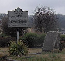
Euro-American settlement in what is now Fountain City began with the completion of Fort Adair
Fort Adair
Fort Adair was a stockade fortification that served as a supply depot for early settlers migrating west. The structure was constructed in 1788 or around 1791 at Grassy Valley, an early European settlement in the Appalachian Ridge-and-Valley region of East Tennessee...
(sometimes called Adair's Station), a supply depot built by Captain John Adair (1732-1827) around 1791 to protect westward-bound migrants from hostile Cherokee
Cherokee
The Cherokee are a Native American people historically settled in the Southeastern United States . Linguistically, they are part of the Iroquoian language family...
in the waning years of the Chickamauga Wars
Chickamauga wars
The Chickamauga Wars were a series of raids, campaigns, ambushes, minor skirmishes, and several full-scale frontier battles which were a continuation of the Cherokee struggle against encroachment by American frontiersmen from the former British colonies...
. The fort's exact location is unknown, but it was likely located in the vicinity of the modern Lynnhurst Cemetery, near the confluence of Adair Creek and First Creek. Adair and his wife are buried atop a hill overlooking the cemetery.
The community that developed around Fort Adair, originally called "Grassy Valley," eventually became known as "Fountain Head." In the mid-1820s, a circuit rider
Circuit rider (Religious)
Circuit rider is a popular term referring to clergy in the earliest years of the United States who were assigned to travel around specific geographic territories to minister to settlers and organize congregations...
named E.F. Sevier (a grandson of John Sevier
John Sevier
John Sevier served four years as the only governor of the State of Franklin and twelve years as Governor of Tennessee. As a U.S. Representative from Tennessee from 1811 until his death...
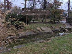
) helped establish the Fountain Head Methodist Church (the predecessor of the present Fountain City United Methodist Church), a meeting house for which was completed just north of the Adair holdings in 1828. Within a few years, the Fountain Head Campground had developed on land adjacent to the meeting house, which was fed by a large spring. The campground was a popular place for religious revivals, some of which hosted as many as 2,000 people, until it was moved to the Inskip area (which was closer to the railroad) in the 1880s. Today, the old campground is home to Fountain City Park.
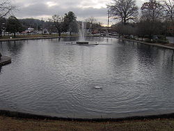
The Fountain Head Campground property was sold to land developers in 1885, and the following year the three-story, fifty-room Fountain Head Hotel was completed, overlooking the campground's spring. With the completion of the hotel, the community began expanding. In 1890, a post office was established, and since the name "Fountain Head" had already been claimed by another town in Tennessee, the community settled on the name "Fountain City." That same year, the heart-shaped Fountain City Lake was completed, and a railroad known as the "Dummy Line" was constructed to connect the community to Knoxville (its southern terminus was at Emory Place
Emory Place Historic District
The Emory Place Historic District is a historic district in Knoxville, Tennessee, USA, located just north of the city's downtown area. The district consists of several commercial, residential, religious, and public buildings that developed around a late nineteenth century train and trolley...
). The Dummy Line remained in operation until 1905, when it was replaced by a trolley
Tram
A tram is a passenger rail vehicle which runs on tracks along public urban streets and also sometimes on separate rights of way. It may also run between cities and/or towns , and/or partially grade separated even in the cities...
.
The 20th century
Knox County, Tennessee
Knox County is a county in the U.S. state of Tennessee. Its 2007 population was estimated at 423,874 by the United States Census Bureau. Its county seat is Knoxville, as it has been since the creation of the county. The county is at the geographical center of the Great Valley of East Tennessee...
purchased the school (which had come into the possession of the Tennessee Baptist Association) in 1906 for the establishment of Central High School
Central High School (Knoxville, Tennessee)
Central High School is a public high school located at 5321 Jacksboro Pike in the Fountain City neighborhood of Knoxville, Tennessee, operated by the Knox County school system...
. In 1919, Hassie K. Gresham (1877-1970), a graduate of Holbrook, was named principal of Central High, making her the first female high school principal in the state of Tennessee. She served as Central's principal until 1947, overseeing a nearly tenfold expansion of the size of the school's student body. When Central moved to its new location in 1971, the middle school
Gresham Middle School (Tennessee)
Gresham Middle School is a grades 6-8 middle school in the Fountain City neighborhood of Knoxville, Tennessee, operated by Knox County Schools. Its enrollment is approximately 1,000 students from ages 10-14...
that replaced it was named for her.
By the 1950s, Fountain City was home to over 30,000 residents. Knoxville, seeking to expand its tax base and form a metropolitan government, attempted to annex Fountain City in 1959. A mail poll showed that Fountain Citians opposed the annexation by a 10 to 1 margin, and the community filed a lawsuit to block it. After Knoxville made a number of concessions, including a one-year moratorium on city taxes, the lawsuit was dropped. On February 12, 1962, in a ceremony that included a mock funeral for what was deemed the death of Fountain City, the community's leaders handed over a symbolic sword to Knoxville mayor John Duncan
John Duncan, Sr.
John James Duncan, Sr. was an American attorney and Republican politician who represented Tennessee's 2nd Congressional District in the U. S. House of Representatives from 1965 until his death in 1988. He also served as Mayor of Knoxville, Tennessee, from 1959 to 1964, and as assistant attorney...
.
Fountain City was voted the best suburban community in Tennessee in 1986 by People magazine.
Education
Along with Central High SchoolCentral High School (Knoxville, Tennessee)
Central High School is a public high school located at 5321 Jacksboro Pike in the Fountain City neighborhood of Knoxville, Tennessee, operated by the Knox County school system...
and Gresham Middle School
Gresham Middle School (Tennessee)
Gresham Middle School is a grades 6-8 middle school in the Fountain City neighborhood of Knoxville, Tennessee, operated by Knox County Schools. Its enrollment is approximately 1,000 students from ages 10-14...
, public schools in Fountain City include Shannondale Elementary, Sterchi Elementary, Fountain City Elementary, and Inskip Elementary. Private schools include Nature's Way Montessori and Garden Montessori schools. Fountainhead College of Technology (formerly Smithwood Elementary, then Tennessee Institute of Electronics) is also located in Fountain City.
Recreation
Fountain City Lake— commonly called the "Duck Pond"— remains one of Fountain City's most prominent features. Parks include Fountain City Park, located on the site of the old Fountain Head Campground, which consists of 12 acre (0.04856232 km²) situated along the small spring that feeds into First Creek, the Fountain City Ball Park (built in 1954), and the Fountain City Art Center (built originally as a library in 1964).External links
- Fountain City history
- Fountain City Town Hall (community organization)
- Knoxville.com Profile of Fountain City