
Namli Maira
Encyclopedia
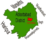
Namli Maira is one of the 51 union councils
of Abbottabad District
in Khyber Pakhtunkhwa province of Pakistan
.
(34.116667°N 73.383333°W). It takes its name from the two largest hamlets
in the Union Council—Namli and Maira. These settlements are nestled on mountain ridge
s about 20 kilometres from the city of Abbottabad
.
A metaled road connects Namli Maira to the main Abbottabad—Nathia Gali
road near Azizabad (Bagnotar
) and is an alternate route to reach Nathia Gali from Abbottabad. It is some 3 kilometres away from the main road (Bagnotar
)
The highest peak in Abbottabad District, Miranjani
, is located in Namli Maira.
7.6 struck the northern areas and Kashmir
, causing significant damage to housing and some deaths. Aftershock
s were felt through December.
Panghora areas.
The most highly populated Mohallas are Maira Klan, Jastar, Proper Namli, and Maira Khurd,paghar and karmala.
JastarBesala):(Very near to "Barhagali"Peshawar Unerersity Campus(Summer).Its link over from "Charrian",Nathia Road to Besala-Jastar.
Poverty has forced many people to seek economic opportunities in the plains. Besides earning livelihood doing odd jobs in nearby towns, many have joined the army and civil services. Hotels in the nearby hill towns of Nathia gali ,Ayubia and Murree provide another source of employment to the locals. After turmoil in Swat, Namli Maira is gradually becoming a favored tourist destination from down country.
(Sardar
) tribe.Other tribes in this area include Turks [Pakistani Turks], Awan, Malik, Abbasi and a handful of Mughals.
Majority of people belong to karlal tribe and are sunni Muslims.
its winters are extreme. Winter lasts from October to April. April tends to be quite pleasant as the climate
is temperate.The summer season is very pleasant and humid the temperature
rises maximum to 25-30 degree,due to which it is good picnic spot.
From mid July to mid August people enjoy the fifth season, monsoon
, which provides relief after the hot months (i.e. May and June). Farming is the main occupation of the people.The farming is done by oxen in the remote area of village but in proper village i.e. namli is ploughed by machinery because of accessibility.the two crops are grown there i.e. rabi
and kharaif. The major rabi crop grown here are potato and maize.the kharaif crop grown there is only wheat but in very small area of village.There are two main purpose of this crop.
1:for cattle
2:For grain
Some vegetable are also found here like turnip, radish, peas, pumpkin, beans and mustard.
At the recently opened S.A Zeb Versatile Academy, the idea is to provide quality education at kindergarten level.
also known as
"Choki" is one of the most popular sites of Namli Maira.The height of Mirajani is approximately 9,000 feet above the sea level.
There is an old track adjacent to Mirajani peak which connects Nathia Gali to Thandiani. Along the track lies a British-era forest rest house, called Dagri Bangla by the locals. Building's location (in the middle of thick forest), colonial style of construction and remoteness accord an aura of mystery to it.
They can also speak and understand Urdu
pashto and English
. The elderly people of the village can also speak and understand Persian
.
Union Councils of Pakistan
A sherwan or village council in Pakistan is an elected local government body consisting of 21 councillors, and headed by a nazim and a naib nazim...
of Abbottabad District
Abbottabad District
Abbottabad is a district in the Khyber Pakhtunkhwa province of Pakistan. The district covers an area of 1,969 km with the city of Abbottabad being the principal town...
in Khyber Pakhtunkhwa province of Pakistan
Pakistan
Pakistan , officially the Islamic Republic of Pakistan is a sovereign state in South Asia. It has a coastline along the Arabian Sea and the Gulf of Oman in the south and is bordered by Afghanistan and Iran in the west, India in the east and China in the far northeast. In the north, Tajikistan...
.
Location
Namli Maira is a mountainous rural area located in Abbottabad DistrictAbbottabad District
Abbottabad is a district in the Khyber Pakhtunkhwa province of Pakistan. The district covers an area of 1,969 km with the city of Abbottabad being the principal town...
(34.116667°N 73.383333°W). It takes its name from the two largest hamlets
Hamlet (place)
A hamlet is usually a rural settlement which is too small to be considered a village, though sometimes the word is used for a different sort of community. Historically, when a hamlet became large enough to justify building a church, it was then classified as a village...
in the Union Council—Namli and Maira. These settlements are nestled on mountain ridge
Ridge
A ridge is a geological feature consisting of a chain of mountains or hills that form a continuous elevated crest for some distance. Ridges are usually termed hills or mountains as well, depending on size. There are several main types of ridges:...
s about 20 kilometres from the city of Abbottabad
Abbottabad
Abbottabad is a city located in the Hazara region of the Khyber Pakhtunkhwa province, in Pakistan. The city is situated in the Orash Valley, northeast of the capital Islamabad and east of Peshawar at an altitude of and is the capital of the Abbottabad District...
.
A metaled road connects Namli Maira to the main Abbottabad—Nathia Gali
Nathia Gali
Nathia Gali or Nathiagali is a mountain resort town or hill station in Hazara, Khyber Pakhtunkhwa, Pakistan. It is a part of the Galiaath which are termed such due to several hill-stations in that area ending with the word "gali", most of which are connected to one other...
road near Azizabad (Bagnotar
Bagnotar
Bagnotar is one of the 51 union councils of Abbottabad District in Khyber-Pakhtunkhwa province of Pakistan. Bagnator is situated on the Abbottabad-Nathi Gali Road some 20 kilometres away from Abbottabad.-Location:...
) and is an alternate route to reach Nathia Gali from Abbottabad. It is some 3 kilometres away from the main road (Bagnotar
Bagnotar
Bagnotar is one of the 51 union councils of Abbottabad District in Khyber-Pakhtunkhwa province of Pakistan. Bagnator is situated on the Abbottabad-Nathi Gali Road some 20 kilometres away from Abbottabad.-Location:...
)
The highest peak in Abbottabad District, Miranjani
Miranjani
Miranjani is the highest peak, at in elevation, of Abbottabad District in the Khyber Pakhtunkhwa Province of Pakistan. It is located in the Namli Maira area, in Ayubia National Park, north of Islamabad in the western Himalayan range....
, is located in Namli Maira.
2005 earthquake
On 8 October 2005 an earthquake of magnitudeRichter magnitude scale
The expression Richter magnitude scale refers to a number of ways to assign a single number to quantify the energy contained in an earthquake....
7.6 struck the northern areas and Kashmir
Kashmir
Kashmir is the northwestern region of the Indian subcontinent. Until the mid-19th century, the term Kashmir geographically denoted only the valley between the Great Himalayas and the Pir Panjal mountain range...
, causing significant damage to housing and some deaths. Aftershock
Aftershock
An aftershock is a smaller earthquake that occurs after a previous large earthquake, in the same area of the main shock. If an aftershock is larger than the main shock, the aftershock is redesignated as the main shock and the original main shock is redesignated as a foreshock...
s were felt through December.
Administration
The Union Council is administratively divided into Dhaki Khaiter, Namli Maira, Noormang, andPanghora areas.
Villages
Villages of Namli Maira include- Namli
- Maira khurd
- Maira kalan
- Noor mang
- Jaster
- Chum
Mohallas
Mohallas of Namli Maira include- Baglain
- Hill
- Proper Namli
- Maira Khurd
- Nakrorri
- Har
- Kandrali
- Dana
- Mundrehi
- Bhandila
- Darwaza
- Kutli
- Chumb
- Lasan Dhiba
- Derah
- Paghar
- Karmalla
- Maira Kalan
- Baghnian
- Jaster
- Besala
- Noor Nala Jastar
- Larri
- Tandi
- Danna
- Upper Kallah
- Lower Kallah
- Khuni Back-Nali
- Thurry
- Upper Maira
- Lower Maira
- Nakrorhi
- Kharhian
- Plutt Khana
- Kalse
- Jabrain
- Bari
- Pull Maira
- Chanati
- Nallah (Upper Maira)
- Chanala
- Bandiali
- garandi
- harjola
- Kholian
- Nala (near Marinjani)
- Basalnaka (upper maira kalan)
The most highly populated Mohallas are Maira Klan, Jastar, Proper Namli, and Maira Khurd,paghar and karmala.
JastarBesala):(Very near to "Barhagali"Peshawar Unerersity Campus(Summer).Its link over from "Charrian",Nathia Road to Besala-Jastar.
Livelihood
The main occupation of the people is subsistence farming and cattle breeding. Farmers cultivate one crop per season as climatic conditions do not permit double cropping. The other occupation is cattle breeding. Cows, sheep and goat are kept for supplying milk for the daily use of the households. Bullocks are used to work the plough.Poverty has forced many people to seek economic opportunities in the plains. Besides earning livelihood doing odd jobs in nearby towns, many have joined the army and civil services. Hotels in the nearby hill towns of Nathia gali ,Ayubia and Murree provide another source of employment to the locals. After turmoil in Swat, Namli Maira is gradually becoming a favored tourist destination from down country.
Ethnic groups
The people of Namli Maira are all Muslims. About 80% belong to the KarlalKarlal
The Karlal are a tribe found in the Abbottabad and Haripur districts of Khyber-Pakhtunkhwa province of Pakistan...
(Sardar
Sardar
Sardar is a title of Indo-Aryan origin that was originally used to denote feudal princes, noblemen, and other aristocrats. It was later applied to indicate a Head of State, a Commander-in-chief, and an Army military rank...
) tribe.Other tribes in this area include Turks [Pakistani Turks], Awan, Malik, Abbasi and a handful of Mughals.
Majority of people belong to karlal tribe and are sunni Muslims.
Climate and crops
As this area is away from sea and is above the sea levelSea level
Mean sea level is a measure of the average height of the ocean's surface ; used as a standard in reckoning land elevation...
its winters are extreme. Winter lasts from October to April. April tends to be quite pleasant as the climate
Climate
Climate encompasses the statistics of temperature, humidity, atmospheric pressure, wind, rainfall, atmospheric particle count and other meteorological elemental measurements in a given region over long periods...
is temperate.The summer season is very pleasant and humid the temperature
Temperature
Temperature is a physical property of matter that quantitatively expresses the common notions of hot and cold. Objects of low temperature are cold, while various degrees of higher temperatures are referred to as warm or hot...
rises maximum to 25-30 degree,due to which it is good picnic spot.
From mid July to mid August people enjoy the fifth season, monsoon
Monsoon
Monsoon is traditionally defined as a seasonal reversing wind accompanied by corresponding changes in precipitation, but is now used to describe seasonal changes in atmospheric circulation and precipitation associated with the asymmetric heating of land and sea...
, which provides relief after the hot months (i.e. May and June). Farming is the main occupation of the people.The farming is done by oxen in the remote area of village but in proper village i.e. namli is ploughed by machinery because of accessibility.the two crops are grown there i.e. rabi
Rabi
Rabi may refer to:* Rabi crop, spring harvest in India and Pakistan* Rabi cycle, in physics is the cyclic behaviour of a two-state quantum system in the presence of an oscillatory driving field...
and kharaif. The major rabi crop grown here are potato and maize.the kharaif crop grown there is only wheat but in very small area of village.There are two main purpose of this crop.
1:for cattle
2:For grain
Some vegetable are also found here like turnip, radish, peas, pumpkin, beans and mustard.
Fruits
Fruit like pear, apple, black grapes, grapes, fig, peach, damson plum, mulberry, wild fig, lemon, apricot, charry are found in abundance in Namli Maira. As the hill people lack awareness about the markets, they are unable to get a proper return. These fruits only meet the requirement of local people.Forests
Most of the area of these hilly hamlets is covered with trees. Peaks are covered with evergreen trees including pine, walnut, oak and maple trees. Herbs, shrubs, wild flowers and thorny bushes can be seen in abundance. Goats and other pet animals graze the pastures. Wood is the primary source of fuel and home construction.Fuel
Wood is used as fuel, it is the primary source of fuel. Gas cylinder are also used as fuel but in very low quantity.Education
Literacy Rate: Namli Maira village has one of the highest literacy rates for the district. The literacy rate of Namli Maira is about 75%. Government and private schools cater to the elementary educational needs of the residents. There are Primary schools for boys and girls, Government Boys High School and Girls High School.A number of private schools are also available, providing the good education at their level. Among them ,Habib Public School, Model Public School, AL-falah public school(chanati) and Iqra Public School(upper maira kalan) are the most popular private schools.At the recently opened S.A Zeb Versatile Academy, the idea is to provide quality education at kindergarten level.
Tourism
Since the earthquake of 2005 the tourists prefer Nathi Gali and surrounding areas like Namli Maira, Kala Bagh, Thandiani and Mushkpuri. Approach to Namli Maira is same from Murree and "Abbottabad" (from both side 32 KM).MiranjaniMiranjani
Miranjani is the highest peak, at in elevation, of Abbottabad District in the Khyber Pakhtunkhwa Province of Pakistan. It is located in the Namli Maira area, in Ayubia National Park, north of Islamabad in the western Himalayan range....
also known as
"Choki" is one of the most popular sites of Namli Maira.The height of Mirajani is approximately 9,000 feet above the sea level.
There is an old track adjacent to Mirajani peak which connects Nathia Gali to Thandiani. Along the track lies a British-era forest rest house, called Dagri Bangla by the locals. Building's location (in the middle of thick forest), colonial style of construction and remoteness accord an aura of mystery to it.
Languages
The mother language of the people of Namli Maira is HindkoHindko language
Hindko , also Hindku, or Hinko, is the sixth main regional language of Pakistan. It forms a subgroup of Indo-Aryan languages spoken by Hindkowans in Pakistan and northern India, some Pashtun tribes in Pakistan, as well as by the Hindki people of Afghanistan...
They can also speak and understand Urdu
Urdu
Urdu is a register of the Hindustani language that is identified with Muslims in South Asia. It belongs to the Indo-European family. Urdu is the national language and lingua franca of Pakistan. It is also widely spoken in some regions of India, where it is one of the 22 scheduled languages and an...
pashto and English
English language
English is a West Germanic language that arose in the Anglo-Saxon kingdoms of England and spread into what was to become south-east Scotland under the influence of the Anglian medieval kingdom of Northumbria...
. The elderly people of the village can also speak and understand Persian
Persian language
Persian is an Iranian language within the Indo-Iranian branch of the Indo-European languages. It is primarily spoken in Iran, Afghanistan, Tajikistan and countries which historically came under Persian influence...
.