
Bagnotar
Encyclopedia
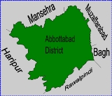
Bagnotar is one of the 51 union councils
of Abbottabad District
in Khyber-Pakhtunkhwa province of Pakistan
. Bagnator is situated on the Abbottabad-Nathi Gali Road some 20 kilometres away from Abbottabad
.
, and lies to the south east of Abbottabad
city - the capital city of the district. The main tribes of Bagnotar are the Jadoon and Sardars Tribes. Bagnotar is bounded by the following union councils, to the north by Sarbhana
, and Beerangali, to the east Nagri Bala & Nathiagali, and to the south by Namli Maira
and Phalkot, and to the west by Bagh.
Bagnotar town has an elevation of 1775 metres, and is located approximately 16 km from Abbottabad on the Abbottabad-Murree
Road. A lush green valley full of pines.
the loss in human life was relatively low in this area, the death toll was recorded as 511, with 622 injured. Although the impact on infrastructure was still severe.
 Bagnotar Union Council is made up of three subdivisions:
a.Samala(b)Sonthi(c)Dhaki(d)Galli(e)Sokar(f)Rajwala(g) RIAN
Union Councils of Pakistan
A sherwan or village council in Pakistan is an elected local government body consisting of 21 councillors, and headed by a nazim and a naib nazim...
of Abbottabad District
Abbottabad District
Abbottabad is a district in the Khyber Pakhtunkhwa province of Pakistan. The district covers an area of 1,969 km with the city of Abbottabad being the principal town...
in Khyber-Pakhtunkhwa province of Pakistan
Pakistan
Pakistan , officially the Islamic Republic of Pakistan is a sovereign state in South Asia. It has a coastline along the Arabian Sea and the Gulf of Oman in the south and is bordered by Afghanistan and Iran in the west, India in the east and China in the far northeast. In the north, Tajikistan...
. Bagnator is situated on the Abbottabad-Nathi Gali Road some 20 kilometres away from Abbottabad
Abbottabad
Abbottabad is a city located in the Hazara region of the Khyber Pakhtunkhwa province, in Pakistan. The city is situated in the Orash Valley, northeast of the capital Islamabad and east of Peshawar at an altitude of and is the capital of the Abbottabad District...
.
Location
The newly formed union council of Bagnotar is situated in the central part of Abbottabad District in Abbottabad TehsilAbbottabad Tehsil
Abbottabad Tehsil is an administrative subdivision of Abbottabad District in Khyber Pakhtunkhwa province of Pakistan.-History:During British rule, the current district of Abbottabad was created as a Tehsil of Hazara District, after the independence of Pakistan it remained a tehsil of Hazara until...
, and lies to the south east of Abbottabad
Abbottabad
Abbottabad is a city located in the Hazara region of the Khyber Pakhtunkhwa province, in Pakistan. The city is situated in the Orash Valley, northeast of the capital Islamabad and east of Peshawar at an altitude of and is the capital of the Abbottabad District...
city - the capital city of the district. The main tribes of Bagnotar are the Jadoon and Sardars Tribes. Bagnotar is bounded by the following union councils, to the north by Sarbhana
Sarbhana
Sarbhana is one of the 51 union councils of Abbottabad District in Khyber-Pakhtunkhwa province of Pakistan .- Location :Sarbhana is located in the west of the district, it is bounded by the following Union Councils, to the north by Kakul, Kuthwal and Beerangali, to the east by Phalkot, to the...
, and Beerangali, to the east Nagri Bala & Nathiagali, and to the south by Namli Maira
Namli Maira
Namli Maira is one of the 51 union councils of Abbottabad District in Khyber Pakhtunkhwa province of Pakistan.- Location :Namli Maira is a mountainous rural area located in Abbottabad District . It takes its name from the two largest hamlets in the Union Council—Namli and Maira...
and Phalkot, and to the west by Bagh.
Bagnotar town has an elevation of 1775 metres, and is located approximately 16 km from Abbottabad on the Abbottabad-Murree
Murree
Murree city is a popular hill station and a summer resort, especially for the residents of Rawalpindi/Islamabad, and for the cities of the province of Punjab, Pakistan...
Road. A lush green valley full of pines.
Earthquake 2005
On 8 October 2005 various parts of Abbottabad District were affected by the massive earthquake, although unlike neighbouring KashmirKashmir
Kashmir is the northwestern region of the Indian subcontinent. Until the mid-19th century, the term Kashmir geographically denoted only the valley between the Great Himalayas and the Pir Panjal mountain range...
the loss in human life was relatively low in this area, the death toll was recorded as 511, with 622 injured. Although the impact on infrastructure was still severe.
Subdivisions
Bagnotar
Important villages and Mohallas:- Gulaga (Dheri) Village
- Karlaan
- Riyali
- Doggrian
- Takkia
- Karati
- KEYALA village
- Chandial
- Khurri Binda
- Jandaan
- Khalabain
- GAIHYA Village
- SEERY Village
- Batangi
- Ghoni
- Kurraan
- Jandial
- Proper Bagnotar
Bandi Maira
Bandi Maira consist of following important Mohallas- Cham Rajpoot
- Proper Bandi
- Maira
- milak abad
a.Samala(b)Sonthi(c)Dhaki(d)Galli(e)Sokar(f)Rajwala(g) RIAN
- Traida
- Galiayand
- Nakrora.
- khirpa
- pari
- dhongi
- sunny
- sorrah
- karati
- Danna
- Palakian
- Baffa
- Gali
Chahan
Chahan consist of following Mohallas- Nuryali
- Chakargally
- Tipper
- Ban
- Salandi
- Choki
- Seergah
- Dana
- Choaha
- Planni
- Bagla
- Sorrah
Public facilities
- Govt Inter College Bagnotar
- Government Boys Higher Secondary School BAGNOTAR
- Government Girls Secondary School Bagnotar (being upgraded to Higher Secondary)
- Government primary, middle, high and higher secondary schools for boys.
- G.o.v.t primary school (Nakrolla, Bandimera) Established 1919
- MODEL POLICE STATION BAGNOTAR (newly re-constructed building after earthquake of 2005) with a Police Post at HARNO BAZAR (picnic spot at the River Harno)
- HOSPITAL. A newly re-constructed Basic Health Unit with residential accommodation for doctor and staff.
- POST OFFICE. A complete govt building of Post Office with residential quarters exist who deliver the mails, money orders and packets to other post offices like Bagh, Bandi Maira, Namli Maira, Phalkot, Beerangali, Malsa, Noormang, Bara Hoter and other branch post offices is delivered. This Post Office is also dealing with the utilities bills and payment of pensionners of the federal and provincial governments besides saving banks facilities.
- IN MULLAH RIAN THERE WAS AONE Government primary School AND ONE higher school FOR BOYS *IN MULLAH RIAN THERE WAS AONE Government primary School AND ONE higher school FOR GIRLS