
Nallamalai Hills
Encyclopedia
The Nallamalas (also called the Nallamalla Range) are a section of the Eastern Ghats
which stretch primarily over Kurnool
, Mahabubnagar, Guntur
, Prakasam
and Kadapa
districts of the state of Andhra Pradesh
, India
. They run in a nearly north-south alignment, parallel to the Coromandel Coast
for close to 430 km between the rivers, Krishna
and Pennar. Its northern boundaries are marked by the flat Palnadu basin while in the south it merges with the Tirupati hills. An extremely old system, the hills have been extensively weathered and eroded over the years. The average elevation today is about 520 m which reaches 1100 m at Bhairani Konda and 1048 m at Gundla Brahmeswara.. Both of these peaks are in a north westerly direction from the town of Cumbum
. There are also many other peaks above 800 m.
 The rocks of the Nallamala ranges belong to the Kadapa system which is a series some 20,000 ft. thick. The primary rocks are Quartzite
overlaid with an irregular slaty formation. Some sandstone
is also to be found. The rocks here are very irregular and soft in texture thus rendering commercial exploitation impossible. These rocks are among the oldest in the world and have been formed as a result of large scale volcanic activity hundreds of millions of years ago. The evidence of the volcanic forces are evident in the foldings into which the rocks have been forced, in some cases the folds have been completely inverted.
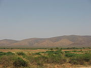
 The Nallamalas have a rather warm to hot climate throughout the year. Rainfall averages about 90 cm and is concentrated in the months of the South West Monsoon
(June–September). The fissured rocks prevent any water from percolating underground and hence most of the discharge runs off as mountain streams to join the Gundlakamma River
, the largest river to arise in these hills. Winters are mostly cool and dry with the average temperature around 25 degrees celsius.
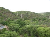
 These hills are almost completely covered with open jungle. Lack of water prevents the growth of large trees and the prevalent vegetation consists of Terminalia, Hardwickia and Pterocarpus. Agriculture is almost non existent apart from isolated patches near villages where subsistence farming is practiced. The Nallamala Forests are probably the largest stretch of undisturbed forest in South India apart from the Western Ghats
and were particularly rich in game till the 1970s. A large part of the forest is a part of the Nagarjunsagar-Srisailam Tiger Reserve that has a viable tiger population. Leopard sightings too are not uncommon. Many of the adventures of the popular wildlife writer, Kenneth Anderson
are set in these forests.
s, a forest dwelling tribe who have remained cut off from the modern world even today. Farming is the primary occupation of the people in the plateaus while the Chenchus are still hunter gatherers.
The hills were a hotbed of Naxal activities until recently. Police action since 2005 has all but cleared the forest of them.
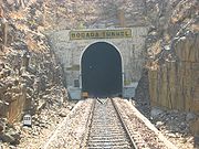
 A state highway and the Vijayawada
-Guntakal
line of the South Central Railway
pass through the hills. The railway was first built by the Madras and Southern Mahratta Railway and is a feat of engineering, having 2 tunnels at Bogada and Chelama and a few viaducts, the most famous being the now abandoned Dorabavi Viaduct. The railway enters the hills at the Nandikama Pass near Cumbum Lake. The highway follows a zig zag alignment and thus avoids any tunnels. The primary exports of this region are forest produce like timber waste, honey and molasses.
on the River Krishna is the site of a large hydroelectric power project as also an ancient and much revered temple dedicated to Lord Shiva. The Cumbum Lake is one of Asia's oldest man made lakes and dates back to the 15th century. A stream descends down the Gundla Brahmeswara peak and ends in a beautiful waterfall and sacred pool called Nemaligundam (Peacock Pool). The Mallela Theertham
waterfall on the river Krishna is also located in this forest.Cumbum lake and dam is another attraction located beside the Nandiyal railway line near Cumbum station.This was built by the Gajapati kings of Orissa for irrigating about 420 km2 farmland by damming a narrow opening between two adjoining hills and later renovated by queen Vardarajamma of Vijayanagar kingdom in 16th.Century.
Chief Minister's Death
On 2 September 2009, a Bell-430 chopper carrying the Andhra Pradesh
Chief Minister
Y.S. Rajasekhara Reddy, with two pilots, a chief security officer and secretary went missing in the Nallamala forest. After nearly twenty four hours of search by police, para military, Indian Army, Indian Air Force, India Space Research Organisation among others, the chopper was located in mangled and burnt state on the top of the 800 ft.Pavuralla Konda (Doves' hill). All the five people died in the crash owing to inclement weather condition .
Eastern Ghats
The Eastern Ghats or Eastern Ghauts are a discontinuous range of mountains along India's eastern coast. The Eastern Ghats run from West Bengal state in the north, through Orissa and Andhra Pradesh to Tamil Nadu in the south passing some parts of Karnataka. They are eroded and cut through by the...
which stretch primarily over Kurnool
Kurnool district
Kurnool District is a district in the state of Andhra Pradesh, India, located in the west-central part of the state on the southern banks of the Tungabhadra and Handri rivers. The town of Kurnool is currently the headquarters of the district...
, Mahabubnagar, Guntur
Guntur district
Guntur district is located in Andhra Pradesh along the east coast of Bay of Bengal. The district has a coastline of around 100 kilometers. Guntur City is the largest city in the district and administrative center of Guntur District. The district is a major center for learning.-Etymology:There are...
, Prakasam
Prakasam district
Prakasam District is an administrative district in the state of Andhra Pradesh, in India. The district headquarters is located at Ongole City...
and Kadapa
Kadapa district
YSR Kadapa District is one of the 23 districts of Andhra Pradesh, India. On 8 July 2010, the government of Andhra Pradesh renamed the district in honor of Y. S...
districts of the state of Andhra Pradesh
Andhra Pradesh
Andhra Pradesh , is one of the 28 states of India, situated on the southeastern coast of India. It is India's fourth largest state by area and fifth largest by population. Its capital and largest city by population is Hyderabad.The total GDP of Andhra Pradesh is $100 billion and is ranked third...
, India
India
India , officially the Republic of India , is a country in South Asia. It is the seventh-largest country by geographical area, the second-most populous country with over 1.2 billion people, and the most populous democracy in the world...
. They run in a nearly north-south alignment, parallel to the Coromandel Coast
Coromandel Coast
The Coromandel Coast is the name given to the southeastern coast of the Indian Subcontinent between Cape Comorin and False Divi Point...
for close to 430 km between the rivers, Krishna
Krishna River
The Krishna River , is one of the longest rivers in central-southern India, about . It is also referred to as Krishnaveni in its original nomenclature...
and Pennar. Its northern boundaries are marked by the flat Palnadu basin while in the south it merges with the Tirupati hills. An extremely old system, the hills have been extensively weathered and eroded over the years. The average elevation today is about 520 m which reaches 1100 m at Bhairani Konda and 1048 m at Gundla Brahmeswara.. Both of these peaks are in a north westerly direction from the town of Cumbum
Cumbum
Cumbum may refer to:*Cumbum, Tamil Nadu - A town in Tamil Nadu in India.*Cumbum, Prakasam district, Andhra Pradesh - A town in Andhra Pradesh in India....
. There are also many other peaks above 800 m.
Geology
Quartzite
Quartzite is a hard metamorphic rock which was originally sandstone. Sandstone is converted into quartzite through heating and pressure usually related to tectonic compression within orogenic belts. Pure quartzite is usually white to gray, though quartzites often occur in various shades of pink...
overlaid with an irregular slaty formation. Some sandstone
Sandstone
Sandstone is a sedimentary rock composed mainly of sand-sized minerals or rock grains.Most sandstone is composed of quartz and/or feldspar because these are the most common minerals in the Earth's crust. Like sand, sandstone may be any colour, but the most common colours are tan, brown, yellow,...
is also to be found. The rocks here are very irregular and soft in texture thus rendering commercial exploitation impossible. These rocks are among the oldest in the world and have been formed as a result of large scale volcanic activity hundreds of millions of years ago. The evidence of the volcanic forces are evident in the foldings into which the rocks have been forced, in some cases the folds have been completely inverted.
Climate
Monsoon
Monsoon is traditionally defined as a seasonal reversing wind accompanied by corresponding changes in precipitation, but is now used to describe seasonal changes in atmospheric circulation and precipitation associated with the asymmetric heating of land and sea...
(June–September). The fissured rocks prevent any water from percolating underground and hence most of the discharge runs off as mountain streams to join the Gundlakamma River
Gundlakamma River
The Gundlakamma is a seasonal river that flows through the east central part of the state of Andhra Pradesh, India. It arises in the Nallamalla Hills, an offshoot of the Eastern Ghats. Its main headwaters lie some 6 kilometers from the village of Ardhaveedu, Prakasam District at an altitude of 425...
, the largest river to arise in these hills. Winters are mostly cool and dry with the average temperature around 25 degrees celsius.
Geography and land use
Western Ghats
The Western Ghats, Western Ghauts or the Sahyādri is a mountain range along the western side of India. It runs north to south along the western edge of the Deccan Plateau, and separates the plateau from a narrow coastal plain along the Arabian Sea. The Western Ghats block rainfall to the Deccan...
and were particularly rich in game till the 1970s. A large part of the forest is a part of the Nagarjunsagar-Srisailam Tiger Reserve that has a viable tiger population. Leopard sightings too are not uncommon. Many of the adventures of the popular wildlife writer, Kenneth Anderson
Kenneth Anderson (writer)
Kenneth Anderson was an Indian writer and hunter who wrote many books about his adventures in the jungles of South India.- Background :...
are set in these forests.
Population
The uneven terrain and the scarcity of water has prevented the growth of any large cities in this region. Nandyal is the largest town in this area and giddalur is the second largest town near by it. The indigenous population consists of the ChenchuChenchu
The Chenchus are an aboriginal tribe of the central hill regions of Andhra Pradesh, India. Their traditional way of life has been based on hunting and gathering. The Chenchus speak the Chenchu language, a member of the Telegu branch of the Dravidian language family. In general, the Chenchu...
s, a forest dwelling tribe who have remained cut off from the modern world even today. Farming is the primary occupation of the people in the plateaus while the Chenchus are still hunter gatherers.
The hills were a hotbed of Naxal activities until recently. Police action since 2005 has all but cleared the forest of them.
Transport
Vijayawada
Vijayawada is the third largest city in Andhra Pradesh, India, located on the banks of the Krishna River and bounded by the Indrakiladri Hills on the West and the Budameru River on the North. The city is located in the Krishna District, about from the state capital Hyderabad.Vijayawada literally...
-Guntakal
Guntakal
Guntakal is a town in Anantapur district in the southwestern part of the state of Andhra Pradesh and 50 km away from Bellary of Karnataka, India. It has a population of 2,26,658...
line of the South Central Railway
Guntur division
Guntur Railway Division is one of the six divisions of South Central Railway , a zone of the Indian Railways. SCR has its head quarters at Secunderabad, Andhra Pradesh and serves almost the whole of the state of Andhra Pradesh, a large part of Maharashtra along with small portions of Madhya...
pass through the hills. The railway was first built by the Madras and Southern Mahratta Railway and is a feat of engineering, having 2 tunnels at Bogada and Chelama and a few viaducts, the most famous being the now abandoned Dorabavi Viaduct. The railway enters the hills at the Nandikama Pass near Cumbum Lake. The highway follows a zig zag alignment and thus avoids any tunnels. The primary exports of this region are forest produce like timber waste, honey and molasses.
Places of interest
SrisailamSrisailam
Srisailam is a holy town and mandal, situated in Nallamala Hills of Kurnool district, Andhra Pradesh, India. It is located on the banks of River Krishna, about 232 km south of Hyderabad....
on the River Krishna is the site of a large hydroelectric power project as also an ancient and much revered temple dedicated to Lord Shiva. The Cumbum Lake is one of Asia's oldest man made lakes and dates back to the 15th century. A stream descends down the Gundla Brahmeswara peak and ends in a beautiful waterfall and sacred pool called Nemaligundam (Peacock Pool). The Mallela Theertham
Mallela Theertham
Mallela Theertham is a waterfall located in the Nallamala Forest in Andhra Pradesh, India. The River Krishna flows through this forest.It is located around 58 KM from Srisailam and 185 KM from Hyderabad. It is a 8 KM diversion from the main Hyderabad - Srisailam interstate...
waterfall on the river Krishna is also located in this forest.Cumbum lake and dam is another attraction located beside the Nandiyal railway line near Cumbum station.This was built by the Gajapati kings of Orissa for irrigating about 420 km2 farmland by damming a narrow opening between two adjoining hills and later renovated by queen Vardarajamma of Vijayanagar kingdom in 16th.Century.
Chief Minister's Death
On 2 September 2009, a Bell-430 chopper carrying the Andhra Pradesh
Andhra Pradesh
Andhra Pradesh , is one of the 28 states of India, situated on the southeastern coast of India. It is India's fourth largest state by area and fifth largest by population. Its capital and largest city by population is Hyderabad.The total GDP of Andhra Pradesh is $100 billion and is ranked third...
Chief Minister
Chief Minister
A Chief Minister is the elected head of government of a sub-national state, provinces of Sri Lanka, Pakistan, notably a state of India, a territory of Australia or a British Overseas Territory that has attained self-government...
Y.S. Rajasekhara Reddy, with two pilots, a chief security officer and secretary went missing in the Nallamala forest. After nearly twenty four hours of search by police, para military, Indian Army, Indian Air Force, India Space Research Organisation among others, the chopper was located in mangled and burnt state on the top of the 800 ft.Pavuralla Konda (Doves' hill). All the five people died in the crash owing to inclement weather condition .