

Myers Park (Auckland)
Encyclopedia
Park
A park is a protected area, in its natural or semi-natural state, or planted, and set aside for human recreation and enjoyment, or for the protection of wildlife or natural habitats. It may consist of rocks, soil, water, flora and fauna and grass areas. Many parks are legally protected by...
in central Auckland
Auckland
The Auckland metropolitan area , in the North Island of New Zealand, is the largest and most populous urban area in the country with residents, percent of the country's population. Auckland also has the largest Polynesian population of any city in the world...
, New Zealand
New Zealand
New Zealand is an island country in the south-western Pacific Ocean comprising two main landmasses and numerous smaller islands. The country is situated some east of Australia across the Tasman Sea, and roughly south of the Pacific island nations of New Caledonia, Fiji, and Tonga...
, running parallel to the upper part of Queen Street
Queen Street, Auckland
Queen Street is the major commercial thoroughfare in the Auckland CBD, Auckland, New Zealand's main population centre. It starts at Queens Wharf on the Auckland waterfront, adjacent to the Britomart Transport Centre and the Downtown Ferry Terminal, and runs uphill for almost three kilometres in a...
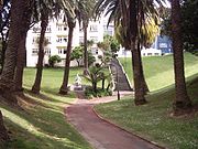
. It is characterised by steep, grassed slopes and canopied with a mixture of large exotic and native trees, including an alley of large palm trees. Benches and artwork (including a heritage marble copy of Michelangelo
Michelangelo
Michelangelo di Lodovico Buonarroti Simoni , commonly known as Michelangelo, was an Italian Renaissance painter, sculptor, architect, poet, and engineer who exerted an unparalleled influence on the development of Western art...
's sitting Moses statue) line the paths connecting to Queen Street
Queen Street, Auckland
Queen Street is the major commercial thoroughfare in the Auckland CBD, Auckland, New Zealand's main population centre. It starts at Queens Wharf on the Auckland waterfront, adjacent to the Britomart Transport Centre and the Downtown Ferry Terminal, and runs uphill for almost three kilometres in a...
, K Road
Karangahape Road
Karangahape Road is one of the main streets in the central business district of Auckland, New Zealand. The massive expansion of motorways through the nearby inner city area - and subsequent flight of residents and retail into the suburbs - turned it from one of Auckland's premier shopping streets...
, Grey's Avenue and Aotea Square
Aotea Square
Aotea Square is a large paved public area in the CBD, of Auckland, New Zealand. Officially opened in 1979 by Sir Dove-Myer Robinson next to Queen Street, it is used for open-air concerts and gatherings, and markets and political rallies....
.
History
Running downhill from the northern slope of the Karangahape ridgeKarangahape Road
Karangahape Road is one of the main streets in the central business district of Auckland, New Zealand. The massive expansion of motorways through the nearby inner city area - and subsequent flight of residents and retail into the suburbs - turned it from one of Auckland's premier shopping streets...
, the park was formed in 1914 out of an overgrown gully
Gully
A gully is a landform created by running water, eroding sharply into soil, typically on a hillside. Gullies resemble large ditches or small valleys, but are metres to tens of metres in depth and width...
facing towards the Waitemata Harbour
Waitemata Harbour
The quite famous Waitemata Harbour is the main access by sea to Auckland, New Zealand. For this reason it is often referred to as Auckland Harbour, despite the fact that it is only one of two harbours surrounding the city, and is crossed by the Auckland Harbour Bridge. The Waitemata forms the north...
. The gully was the start of the Waihorotiu Stream
Waihorotiu Stream
The Waihorutiu Stream , also called the 'Queen Street River', is a former stream in the downtown region of Auckland City, New Zealand, which has long since been covered over and made to disappear by the increasing urbanisation of the area.-History:Originally, it was an open stream starting out in a...
, also known as the 'Queen Street River', temporarily used as an open sewer, now underground. Around 1914, the area of the gully was described as consisting of "slum shanties and rubbish tips", until a former Mayor of Auckland
Mayor of Auckland
The Mayor of Auckland is the directly elected head of the Auckland Council, the local government authority for the Auckland region in New Zealand...
Arthur Mielzinier Myers
Arthur Myers
Sir Arthur Mielziner Myers was a New Zealand politician. He was Mayor of Auckland City from 1905 to 1909, Member of the House of Representatives from 1910 to 1921, and a Cabinet Minister...
donated £9,000 to the city to buy the area and transform 2.4 ha of the wasteland into Myers Park.
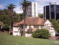
In 1915 Myers also funded the construction of the Myers Free Kindergarten, a fine example of Arts & Crafts architecture
Arts and Crafts movement
Arts and Crafts was an international design philosophy that originated in England and flourished between 1860 and 1910 , continuing its influence until the 1930s...
(Chilwell & Trevithick Architects). The kindergarten, like a similar gift of other philanthropists in Victoria Park
Victoria Park, Auckland
Victoria Park is a park and sports ground in Auckland City, New Zealand. It lies on reclaimed bay land in Freemans Bay, a suburb directly west of the Auckland CBD. This origin of the land makes it very flat and level...
, was intended to benefit the mostly poor families of the area. The building still holds a kindergarten today (KiNZ in the Park) and is, together with parts of the park itself, on the register of the Historic Places Trust.
The park also contains the caretaker's cottage, one of only two Kauri buildings on Queen Street that are more than 100 years old.