
Mount Timpanogos
Encyclopedia
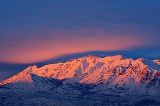
Mount Timpanogos, sometimes informally referred to as Timp, is the second highest mountain
in Utah
's Wasatch Range
. Timpanogos rises to an elevation of 11,749 feet (3,582 m) above sea level in the Uinta National Forest
(now part of the Wasatch-Cache National Forest
). With 5,269 feet of topographic prominence
, Timpanogos is the 47th-most prominent mountain in the contiguous United States
.
The mountain towers over Utah Valley
, including the cities of Lehi, Provo
, Orem
, Pleasant Grove
, American Fork
, Lindon
and others. The exposed portion of the mountain is made up entirely of limestone
and dolomite
from the Pennsylvanian period, and is about 300 million years old. Heavy winter snowfall is characteristic of this portion of the Wasatch Range, and avalanche activity is common in winter and spring.
The word Timpanogos comes from the Timpanogots tribe who lived in the surrounding valleys from AD 1400. The name translates as rock (tumpi-), and water mouth or canyon (panogos).
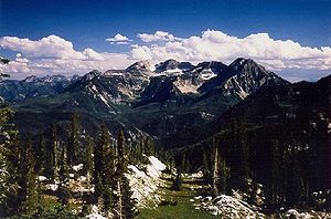
.jpg) Mount Timpanogos displays many examples of textbook glacial processes and provides stark evidence of the sculpting power of moving ice. Ice Age glaciers mantled the peak until relatively recently, and dramatically shaped the mountain into an Alpine tableau of knife-edge ridges and yawning, U-shaped amphitheaters. A remnant of these glaciers persists in the deeply recessed valley below the main summit. "Timp Glacier" is a rock-covered mass found on a long, north-facing slope, and is snow-covered for much of the year. It exhibits morphological characteristics found in both true glaciers and rock glaciers. Periodically-visible crevasses and sporadically audible flowing water below the rock-strewn surface hint at deeply-buried glacial ice, while other elements of the "glacier", such as an apparent lack of movement, suggest to some the jumbled assemblage may in fact be a rock glacier
Mount Timpanogos displays many examples of textbook glacial processes and provides stark evidence of the sculpting power of moving ice. Ice Age glaciers mantled the peak until relatively recently, and dramatically shaped the mountain into an Alpine tableau of knife-edge ridges and yawning, U-shaped amphitheaters. A remnant of these glaciers persists in the deeply recessed valley below the main summit. "Timp Glacier" is a rock-covered mass found on a long, north-facing slope, and is snow-covered for much of the year. It exhibits morphological characteristics found in both true glaciers and rock glaciers. Periodically-visible crevasses and sporadically audible flowing water below the rock-strewn surface hint at deeply-buried glacial ice, while other elements of the "glacier", such as an apparent lack of movement, suggest to some the jumbled assemblage may in fact be a rock glacier
, composed of unsorted lithic aggregate cemented together in an icy matrix, flowing downhill. Furthermore, it is also possible that Timp Glacier may indeed be a small glacier completely obscured by talus and other debris: thus, a "rock covered glacier". The locally-unique ice is a relic of the region's formerly colder climate and has long been a major attraction to hikers and climbers on the mountain. Its precise classification remains the subject of spirited ongoing debate, whether "real" or not.
/climbing
destinations and is climbed year round. Winter climbing requires advanced mountaineering ability. In spring, undercutting of deeply-drifted snow by streams creates a hazard that has proven fatal on more than one occasion. Climbers can fall through the undermined snow fifty feet or more into the icy stream underneath.
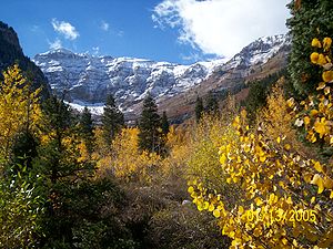
Although it is a 14-mile round-trip hike, with almost a mile of elevation gain, Timp's summit is one of the most-visited in the Rocky Mountains
. There are two main trails to the top: the first starts at Aspen Grove with a trailhead elevation of 6,910 feet (2,106 meters), and the second starts at the Timpooneke campground in American Fork Canyon
at 7,370 feet (2,185 meters). The two trails are nearly exactly the same length. Hikers on the trails climb through montane forest
, subalpine
and alpine
zones. The hike is marked by waterfalls, conifers, rocky slopes and ridges, mountain goats, and a small lake, Emerald Lake
, at 10,380 feet (3,164 m). A short diversion will lead hikers past a World War II bomber crash site. Other climbing routes exist on the mountain, but they are more technically demanding and require special skills and mountaineering
gear.
Prior to 1970, an annual Provo event called the "Timp Hike" sent thousands of people up the mountain's slopes. From 1911 to 1970 this one-day event (which took place generally on the third or fourth weekend in July) attracted thousands of people to the mountain. It also created the need for infrastructure, such as the stone shelter built in 1959 near Emerald Lake and a smaller metal shack on the summit (this was used as an observation deck
complete with brass rods etched with notches aligned with various landmarks). The hike caused environmental damage to the mountain, and was finally canceled to help preserve the delicate mountain ecosystem. Despite the presence of the existing structures, the mountain was designated a wilderness area by the U.S. Congress in 1984.
The Timp Glacier is one of the major sources of injury or death to hikers on Timp, particularly when some attempt to "glissade" (or slide rapidly) down the snowfield's surface with the assistance of a shovel or other device to save time descending. There have been many cases of injuries from buried rocks under the snow as well. There have been numerous life flight rescues on the mountain, often caused by this activity. The frequency of these rescues, however, greatly diminished once TERT was established.
Mountain
Image:Himalaya_annotated.jpg|thumb|right|The Himalayan mountain range with Mount Everestrect 58 14 160 49 Chomo Lonzorect 200 28 335 52 Makalurect 378 24 566 45 Mount Everestrect 188 581 920 656 Tibetan Plateaurect 250 406 340 427 Rong River...
in Utah
Utah
Utah is a state in the Western United States. It was the 45th state to join the Union, on January 4, 1896. Approximately 80% of Utah's 2,763,885 people live along the Wasatch Front, centering on Salt Lake City. This leaves vast expanses of the state nearly uninhabited, making the population the...
's Wasatch Range
Wasatch Range
The Wasatch Range is a mountain range that stretches approximately from the Utah-Idaho border, south through central Utah in the western United States. It is generally considered the western edge of the greater Rocky Mountains, and the eastern edge of the Great Basin region...
. Timpanogos rises to an elevation of 11,749 feet (3,582 m) above sea level in the Uinta National Forest
Uinta National Forest
Uinta National Forest is a national forest located in north central Utah, USA. It was originally part of the Uinta Forest Reserve, created by Grover Cleveland on February 2, 1897. The name is derived from the Ute word Yoov-we-teuh which means pine forest...
(now part of the Wasatch-Cache National Forest
Wasatch-Cache National Forest
Uinta-Wasatch-Cache National Forest is a United States National Forest located primarily in northern Utah , with smaller parts extending into southeastern Idaho and southwestern Wyoming . The name is from the Ute word Wasatch for a low place in high mountains, and the French word Cache meaning to...
). With 5,269 feet of topographic prominence
Topographic prominence
In topography, prominence, also known as autonomous height, relative height, shoulder drop , or prime factor , categorizes the height of the mountain's or hill's summit by the elevation between it and the lowest contour line encircling it and no higher summit...
, Timpanogos is the 47th-most prominent mountain in the contiguous United States
Contiguous United States
The contiguous United States are the 48 U.S. states on the continent of North America that are south of Canada and north of Mexico, plus the District of Columbia....
.
The mountain towers over Utah Valley
Utah Valley
Utah Valley is a valley in North Central Utah located in Utah County, and is considered part of the Wasatch Front. It contains Provo, Orem, and their suburbs, including Highland, Eagle Mountain, Saratoga Springs, Mapleton, Spanish Fork, Lindon, Pleasant Grove, Springville, Lehi, Payson, and...
, including the cities of Lehi, Provo
Provo, Utah
Provo is the third largest city in the U.S. state of Utah, located about south of Salt Lake City along the Wasatch Front. Provo is the county seat of Utah County and lies between the cities of Orem to the north and Springville to the south...
, Orem
Orem, Utah
Orem is a city in Utah County, Utah, United States, in the north-central part of the state. It is adjacent to Provo, Lindon, and Vineyard and is about south of Salt Lake City. Orem is one of the principal cities of the Provo-Orem, Utah Metropolitan Statistical Area, which includes all of Utah and...
, Pleasant Grove
Pleasant Grove, Utah
Pleasant Grove, also known as "Utah's City of Trees", is a city in Utah County, Utah, United States. It is part of the Provo–Orem, Utah Metropolitan Statistical Area. The population was 33,798 at the 2008 census estimates.-History:...
, American Fork
American Fork, Utah
American Fork is a city in Utah County, Utah, United States, at the foot of Mount Timpanogos in the Wasatch Range, north of Utah Lake. It is part of the Provo–Orem, Utah Metropolitan Statistical Area. The population was 26,263 at the 2010 census, nearly a 20% growth since the 2000 census...
, Lindon
Lindon, Utah
Lindon is a city in Utah County, Utah, United States. It is part of the Provo–Orem, Utah Metropolitan Statistical Area. The population was 10,070 at the 2010 census.The western sculptor Grant Speed resides in Lindon.-Geography:...
and others. The exposed portion of the mountain is made up entirely of limestone
Limestone
Limestone is a sedimentary rock composed largely of the minerals calcite and aragonite, which are different crystal forms of calcium carbonate . Many limestones are composed from skeletal fragments of marine organisms such as coral or foraminifera....
and dolomite
Dolomite
Dolomite is a carbonate mineral composed of calcium magnesium carbonate CaMg2. The term is also used to describe the sedimentary carbonate rock dolostone....
from the Pennsylvanian period, and is about 300 million years old. Heavy winter snowfall is characteristic of this portion of the Wasatch Range, and avalanche activity is common in winter and spring.
The word Timpanogos comes from the Timpanogots tribe who lived in the surrounding valleys from AD 1400. The name translates as rock (tumpi-), and water mouth or canyon (panogos).
An icy mystery
Rock glacier
Rock glaciers are distinctive geomorphological landforms of angular rock debris frozen in interstitial ice which may extend outward and downslope from talus cones, glaciers or terminal moraines of glaciers. There are two types of rock glaciers: periglacial glaciers, or talus-derived glaciers, and...
, composed of unsorted lithic aggregate cemented together in an icy matrix, flowing downhill. Furthermore, it is also possible that Timp Glacier may indeed be a small glacier completely obscured by talus and other debris: thus, a "rock covered glacier". The locally-unique ice is a relic of the region's formerly colder climate and has long been a major attraction to hikers and climbers on the mountain. Its precise classification remains the subject of spirited ongoing debate, whether "real" or not.
Hiking Timpanogos
Mount Timpanogos is one of Utah's most popular hikingHiking
Hiking is an outdoor activity which consists of walking in natural environments, often in mountainous or other scenic terrain. People often hike on hiking trails. It is such a popular activity that there are numerous hiking organizations worldwide. The health benefits of different types of hiking...
/climbing
Climbing
Climbing is the activity of using one's hands and feet to ascend a steep object. It is done both for recreation and professionally, as part of activities such as maintenance of a structure, or military operations.Climbing activities include:* Bouldering: Ascending boulders or small...
destinations and is climbed year round. Winter climbing requires advanced mountaineering ability. In spring, undercutting of deeply-drifted snow by streams creates a hazard that has proven fatal on more than one occasion. Climbers can fall through the undermined snow fifty feet or more into the icy stream underneath.
Although it is a 14-mile round-trip hike, with almost a mile of elevation gain, Timp's summit is one of the most-visited in the Rocky Mountains
Rocky Mountains
The Rocky Mountains are a major mountain range in western North America. The Rocky Mountains stretch more than from the northernmost part of British Columbia, in western Canada, to New Mexico, in the southwestern United States...
. There are two main trails to the top: the first starts at Aspen Grove with a trailhead elevation of 6,910 feet (2,106 meters), and the second starts at the Timpooneke campground in American Fork Canyon
American Fork Canyon
American Fork Canyon is a canyon located in the Wasatch Mountains of Utah. The canyon is famous for the Timpanogos Cave National Monument, which resides on its south side...
at 7,370 feet (2,185 meters). The two trails are nearly exactly the same length. Hikers on the trails climb through montane forest
Forest
A forest, also referred to as a wood or the woods, is an area with a high density of trees. As with cities, depending where you are in the world, what is considered a forest may vary significantly in size and have various classification according to how and what of the forest is composed...
, subalpine
Subalpine
The subalpine zone is the biotic zone immediately below tree line around the world. Species that occur in this zone depend on the location of the zone on the Earth, for example, Snow Gum in Australia, or Subalpine Larch, Mountain Hemlock and Subalpine Fir in western North America.Trees in the...
and alpine
Alpine climate
Alpine climate is the average weather for a region above the tree line. This climate is also referred to as mountain climate or highland climate....
zones. The hike is marked by waterfalls, conifers, rocky slopes and ridges, mountain goats, and a small lake, Emerald Lake
Emerald Lake (Utah)
Emerald Lake is a small lake near the summit of Mount Timpanogos in Utah's Wasatch Range. It is northeast of the summit, at the base of the almost vertical northeast face of the mountain. Mount Timp Glacier flows downhill to the lake, and probably provides most of the lake's water inflow during...
, at 10,380 feet (3,164 m). A short diversion will lead hikers past a World War II bomber crash site. Other climbing routes exist on the mountain, but they are more technically demanding and require special skills and mountaineering
Mountaineering
Mountaineering or mountain climbing is the sport, hobby or profession of hiking, skiing, and climbing mountains. While mountaineering began as attempts to reach the highest point of unclimbed mountains it has branched into specialisations that address different aspects of the mountain and consists...
gear.
Prior to 1970, an annual Provo event called the "Timp Hike" sent thousands of people up the mountain's slopes. From 1911 to 1970 this one-day event (which took place generally on the third or fourth weekend in July) attracted thousands of people to the mountain. It also created the need for infrastructure, such as the stone shelter built in 1959 near Emerald Lake and a smaller metal shack on the summit (this was used as an observation deck
Observation deck
__FORCETOC__ An observation deck, observation platform or viewing platform is an elevated sightseeing platform usually situated upon a tall architectural structure such as a skyscraper or observation tower...
complete with brass rods etched with notches aligned with various landmarks). The hike caused environmental damage to the mountain, and was finally canceled to help preserve the delicate mountain ecosystem. Despite the presence of the existing structures, the mountain was designated a wilderness area by the U.S. Congress in 1984.
Hazards
Since 1982 the Timpanogos Emergency Response Team ("TERT") has been established on the mountain on weekends to provide first aid, rescue and communication.http://www.tert.org.The Timp Glacier is one of the major sources of injury or death to hikers on Timp, particularly when some attempt to "glissade" (or slide rapidly) down the snowfield's surface with the assistance of a shovel or other device to save time descending. There have been many cases of injuries from buried rocks under the snow as well. There have been numerous life flight rescues on the mountain, often caused by this activity. The frequency of these rescues, however, greatly diminished once TERT was established.
Legends and folklore
Viewed from the Heber Valley to the northeast, Mount Timpanogos resembles the profile of a sleeping woman. Various legends are told of an Indian maiden who died of grief after her lover was killed, with one version the basis for a ballet, but there is no evidence that any of these are actual Native American myths. It is possible the romantic story was created in the early 1900s by Eugene Lusk "Timp" Roberts, a professor at Brigham Young University who initiated an annual hike and pageant intended to "sell Timpanogos to the world."See also
- Mountain peaks of North AmericaMountain peaks of North AmericaThis article comprises three sortable tables of major mountain peaks of greater North America.This article defines greater North America as the portion of the continental landmass of the Americas extending northward from Panama plus the islands surrounding that landmass...
- Mountain peaks of the Rocky MountainsMountain peaks of the Rocky MountainsThis article comprises three sortable tables of major mountain peaks of the Rocky Mountains of North America.Topographic elevation is the vertical distance above the reference geoid, a precise mathematical model of the Earth's sea level as an equipotential gravitational surface...
- Mountain peaks of the United StatesMountain peaks of the United StatesThis article comprises three sortable tables of the major mountain peaks of the United States of America.Topographic elevation is the vertical distance above the reference geoid, a precise mathematical model of the Earth's sea level as an equipotential gravitational surface...
- Timpanogos Cave National MonumentTimpanogos Cave National MonumentTimpanogos Cave National Monument is a cave system in the Wasatch mountains in American Fork Canyon near American Fork, Utah, in the United States. The 1.5 mile trail to the cave is steep at several points, but paved and wide, so the cave opening is accessible to most...
- Mount Timpanogos WildernessMount Timpanogos WildernessMount Timpanogos Wilderness is a wilderness area protecting Mount Timpanogos and the surrounding area. It is located in the front range of the Wasatch Mountain Range, between American Fork Canyon on the north and Provo Canyon on the south, within the Uinta National Forest in the U.S. state of Utah...
External links
- Summitpost page for Mount Timpanogos - hiking and climbing routes, history, etc.