
Mount Sunapee
Encyclopedia
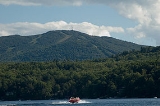
Mount Sunapee is a 5 miles (8 km)-long mountain ridge in the towns of Newbury
and Goshen
in western New Hampshire. Its highest peak, at the north end of the mountain, is 2726 feet (831 m) above sea level
. The mountain has three secondary peaks, White Ledges at 2716 ft (828 m); North Peak at 2280 ft (695 m); and South Peak at 2608 ft (795 m). The north end of the mountain, including the summit, is within Mount Sunapee State Park, which encompasses 3.85 square miles (10 km²). The mountain extends south to Pillsbury State Park
and is home to the popular Mount Sunapee Resort
.
The entire mountain ridge is traversed by the Monadnock-Sunapee Greenway
, a hiking trail that links the summit of Sunapee with that of Mount Monadnock
, 50 miles (80.5 km) to the south in the town of Jaffrey, New Hampshire
. Also crossing the summit in an east-west route is a section of the Sunapee-Ragged
-Kearsarge Greenway, a 75 miles (120.7 km) trail linking ten towns in west-central New Hampshire as it circles the Lake Sunapee region and crosses the summits of the three mountains for which it is named. The two Greenway trails meet at Lake Solitude and use the same trail to the summit.
and Connecticut River
watersheds
. Lake Solitude
, a 4.61 acres (1.9 ha) body of water, lies just 1000 feet (304.8 m) southeast of the White Ledges summit, at an elevation of 2510 feet (765 m). The lake flows into Andrew Brook, a tributary of the Warner River
in the Merrimack River
watershed. Farther south along the ridge, the east slopes of the mountain drain via the West Branch of the Warner River
into the Warner and Merrimack rivers.
The northern and western sides of the mountain drain to the Connecticut River. Johnson Brook flows down the north slopes of the mountain, entering Lake Sunapee
, the outlet of which (the Sugar River
) flows west to the Connecticut in Claremont
. On the western slopes of the mountain, Gunnison Brook, Blood Brook, and Baker Brook flow to the South Branch
of the Sugar River. The southwestern end of the mountain drains via Cherry Brook into the headwaters of the Ashuelot River
, which reaches the Connecticut River near the Massachusetts
border.
 Snow skiing and snowboard riding are popular winter activities at Mount Sunapee Resort & Ski Area
. The ski area lies within Mount Sunapee State Park, but in 1998 the state leased the 968 acres (391.7 ha) ski area of the park to be operated by Tim and Dianne Mueller, who own Okemo Mountain Resort
. New lifts were added in 2004.
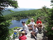
The state park's extensive trail system is used in all seasons for hiking and in winter for snowshoeing. The park is linked to Pillsbury State Park and southern New Hampshire by the 50 miles (80.5 km) Monadnock-Sunapee Greenway and to the ten-town Lake Sunapee region by the 75 miles (120.7 km) "emerald necklace" of the Sunapee-Ragged-Kearsarge (SRK) Greenway which connects Mt. Sunapee to Wadleigh State Park in Sutton
and to Winslow and Rollins State Park
s on Mount Kearsarge in Warner
and Wilmot
. From the ski area parking, the Summit Trail travels two miles (3 km) along the western slope to the summit, where it meets the Solitude Trail for a one-mile (1.6 km) walk to Lake Solitude and White Ledges. The Solitude Trail then links to several trails, notably the popular Andrew Brook Trail and the steeper Newbury Trail, both heading eastward, and to the M-S Greenway as it heads south along Sunapee Mountain toward Pillsbury State Park.
Every August, Mount Sunapee Resort is host to the week-long League of New Hampshire Craftsmen's Fair, billed as "the oldest craft fair in America".
Mount Sunapee is also home to the Mount Sunapee Slush Cup, an annual event where participants welcome the coming of spring by attempting to ski or snowboard across a 90-ft. man-made pond. “Slushers” race down a 365 ft. slope to brave the ice-cold water and compete in several age groups for titles like “Best Skim,” “Best Costume,” and “Best Splash.” Locals and Slush Cup enthusiasts will celebrate the 13th Annual Sunapee Slush Cup in April 2011.
Mount Sunapee State Park beach, also known as Newbury Beach, is just off the traffic circle at the entrance to the state park. The beach has a store, canoe and kayak rentals, a playground, and a new bathhouse. A boat launch is available with some restrictions.
Newbury, New Hampshire
Newbury is a town in Merrimack County, New Hampshire, United States. The population was 2,072 at the 2010 census. Newbury is home to part of Lake Sunapee, including Mount Sunapee State Park Beach. Mount Sunapee Resort, a ski area in Mount Sunapee State Park, is in the west...
and Goshen
Goshen, New Hampshire
Goshen is a town in Sullivan County, New Hampshire, United States. The population was 810 at the 2010 census.- History :Incorporated in 1791, Goshen was first settled in 1768 as a part of Saville...
in western New Hampshire. Its highest peak, at the north end of the mountain, is 2726 feet (831 m) above sea level
Sea level
Mean sea level is a measure of the average height of the ocean's surface ; used as a standard in reckoning land elevation...
. The mountain has three secondary peaks, White Ledges at 2716 ft (828 m); North Peak at 2280 ft (695 m); and South Peak at 2608 ft (795 m). The north end of the mountain, including the summit, is within Mount Sunapee State Park, which encompasses 3.85 square miles (10 km²). The mountain extends south to Pillsbury State Park
Pillsbury State Park
Pillsbury State Park is a state park located mainly in Washington and partially in Goshen, New Hampshire. It is home to the headwaters of the Ashuelot River.-External links:*...
and is home to the popular Mount Sunapee Resort
Mount Sunapee Resort
-History:Mount Sunapee's history as a ski area dates back to as early as 1940, when in response to the success of a tram at Cannon Mountain a survey was made for a similar tram on Mount Sunapee. The following year, the state of New Hampshire passed the Mt...
.
The entire mountain ridge is traversed by the Monadnock-Sunapee Greenway
Monadnock-Sunapee Greenway
The Monadnock-Sunapee Greenway is a hiking trail that traverses the highlands of southern New Hampshire from Mount Monadnock in Jaffrey to Mount Sunapee in Newbury...
, a hiking trail that links the summit of Sunapee with that of Mount Monadnock
Mount Monadnock
Mount Monadnock, or Grand Monadnock, is the most prominent New England mountain peak south of the White Mountains and east of the Massachusetts Berkshires, and is the highest point in Cheshire County, New Hampshire...
, 50 miles (80.5 km) to the south in the town of Jaffrey, New Hampshire
Jaffrey, New Hampshire
Jaffrey is a town in Cheshire County, New Hampshire, United States. The population was 5,457 at the 2010 census.The primary settlement in town, where 2,757 people resided at the 2010 census, is defined as the Jaffrey census-designated place and is located along the Contoocook River at the...
. Also crossing the summit in an east-west route is a section of the Sunapee-Ragged
Ragged Mountain (New Hampshire)
Ragged Mountain is a low mountain with numerous knobby summits in the towns of Danbury and Andover in central New Hampshire. It is home to the Ragged Mountain ski resort.-Geography:In his book, The History of the Town of Andover, John R...
-Kearsarge Greenway, a 75 miles (120.7 km) trail linking ten towns in west-central New Hampshire as it circles the Lake Sunapee region and crosses the summits of the three mountains for which it is named. The two Greenway trails meet at Lake Solitude and use the same trail to the summit.
Hydrology
The ridgeline of Sunapee Mountain forms the divide between the Merrimack RiverMerrimack River
The Merrimack River is a river in the northeastern United States. It rises at the confluence of the Pemigewasset and Winnipesaukee rivers in Franklin, New Hampshire, flows southward into Massachusetts, and then flows northeast until it empties into the Atlantic Ocean at Newburyport...
and Connecticut River
Connecticut River
The Connecticut River is the largest and longest river in New England, and also an American Heritage River. It flows roughly south, starting from the Fourth Connecticut Lake in New Hampshire. After flowing through the remaining Connecticut Lakes and Lake Francis, it defines the border between the...
watersheds
Drainage basin
A drainage basin is an extent or an area of land where surface water from rain and melting snow or ice converges to a single point, usually the exit of the basin, where the waters join another waterbody, such as a river, lake, reservoir, estuary, wetland, sea, or ocean...
. Lake Solitude
Lake Solitude (New Hampshire)
Lake Solitude, , is a highland tarn located at the top of Sunapee Ridge between the main summit of Mount Sunapee and South Peak. The lake, 4.61 acres , is approximately long by wide and is located within Newbury, New Hampshire and Mount Sunapee State Park. A popular hiking destination, Lake...
, a 4.61 acres (1.9 ha) body of water, lies just 1000 feet (304.8 m) southeast of the White Ledges summit, at an elevation of 2510 feet (765 m). The lake flows into Andrew Brook, a tributary of the Warner River
Warner River
The Warner River is a river located in central New Hampshire in the United States. It is a tributary of the Contoocook River, part of the Merrimack River watershed....
in the Merrimack River
Merrimack River
The Merrimack River is a river in the northeastern United States. It rises at the confluence of the Pemigewasset and Winnipesaukee rivers in Franklin, New Hampshire, flows southward into Massachusetts, and then flows northeast until it empties into the Atlantic Ocean at Newburyport...
watershed. Farther south along the ridge, the east slopes of the mountain drain via the West Branch of the Warner River
West Branch Warner River
The West Branch of the Warner River is a river located in central New Hampshire in the United States. It is a tributary of the Warner River, part of the Contoocook River watershed....
into the Warner and Merrimack rivers.
The northern and western sides of the mountain drain to the Connecticut River. Johnson Brook flows down the north slopes of the mountain, entering Lake Sunapee
Lake Sunapee
Lake Sunapee is located within Sullivan County and Merrimack County in western New Hampshire, the United States. It is the fifth-largest lake located entirely in New Hampshire....
, the outlet of which (the Sugar River
Sugar River (New Hampshire)
The Sugar River is a 27.0 mile long river located in western New Hampshire in the United States. It is a tributary of the Connecticut River, which flows to Long Island Sound....
) flows west to the Connecticut in Claremont
Claremont, New Hampshire
There were 5,685 households out of which 27.4% had children under the age of 18 living with them, 45.5% were married couples living together, 10.3% had a female householder with no husband present, and 39.7% were non-families. 32.2% of all households were made up of individuals and 14.7% had...
. On the western slopes of the mountain, Gunnison Brook, Blood Brook, and Baker Brook flow to the South Branch
South Branch Sugar River
The South Branch of the Sugar River is a 6.6 mile long river located in western New Hampshire in the United States. It is a tributary of the Sugar River, which flows to the Connecticut River, which flows to Long Island Sound....
of the Sugar River. The southwestern end of the mountain drains via Cherry Brook into the headwaters of the Ashuelot River
Ashuelot River
The Ashuelot River is a tributary of the Connecticut River, approximately long, in southwestern New Hampshire in the United States. It drains a mountainous area of , including much of the area known as the Monadnock Region...
, which reaches the Connecticut River near the Massachusetts
Massachusetts
The Commonwealth of Massachusetts is a state in the New England region of the northeastern United States of America. It is bordered by Rhode Island and Connecticut to the south, New York to the west, and Vermont and New Hampshire to the north; at its east lies the Atlantic Ocean. As of the 2010...
border.
Recreation
Mount Sunapee Resort
-History:Mount Sunapee's history as a ski area dates back to as early as 1940, when in response to the success of a tram at Cannon Mountain a survey was made for a similar tram on Mount Sunapee. The following year, the state of New Hampshire passed the Mt...
. The ski area lies within Mount Sunapee State Park, but in 1998 the state leased the 968 acres (391.7 ha) ski area of the park to be operated by Tim and Dianne Mueller, who own Okemo Mountain Resort
Okemo Mountain
Okemo Mountain Resort is a ski resort located in Ludlow, Vermont. Before becoming a popular ski resort destination, Ludlow was originally a mill town, and was the home of a General Electric plant until 1977. The resort experienced 600,000 skier visits in 2009...
. New lifts were added in 2004.
The state park's extensive trail system is used in all seasons for hiking and in winter for snowshoeing. The park is linked to Pillsbury State Park and southern New Hampshire by the 50 miles (80.5 km) Monadnock-Sunapee Greenway and to the ten-town Lake Sunapee region by the 75 miles (120.7 km) "emerald necklace" of the Sunapee-Ragged-Kearsarge (SRK) Greenway which connects Mt. Sunapee to Wadleigh State Park in Sutton
Sutton, New Hampshire
Sutton is a town in Merrimack County, New Hampshire, United States. The population was 1,837 at the 2010 census. Sutton is home to Wadleigh State Beach on Kezar Lake.-History:...
and to Winslow and Rollins State Park
Rollins State Park
Rollins State Park is a state park in Warner, New Hampshire. It is located at the southern base of Mount Kearsarge, at the entrance to an auto road that ascends to within of the summit. Picnic facilities are available, and hiking trails leave from the high point of the auto road to the...
s on Mount Kearsarge in Warner
Warner, New Hampshire
Warner is a town in Merrimack County, New Hampshire, United States. The population was 2,833 at the 2010 census. The town is home to The College of Saint Mary Magdalen, Rollins State Park and Mount Kearsarge State Forest....
and Wilmot
Wilmot, New Hampshire
Wilmot is a town in Merrimack County, New Hampshire, United States. The population was 1,358 at the 2010 census. Wilmot is home to Winslow State Park and a small part of Gile State Forest.-History:...
. From the ski area parking, the Summit Trail travels two miles (3 km) along the western slope to the summit, where it meets the Solitude Trail for a one-mile (1.6 km) walk to Lake Solitude and White Ledges. The Solitude Trail then links to several trails, notably the popular Andrew Brook Trail and the steeper Newbury Trail, both heading eastward, and to the M-S Greenway as it heads south along Sunapee Mountain toward Pillsbury State Park.
Every August, Mount Sunapee Resort is host to the week-long League of New Hampshire Craftsmen's Fair, billed as "the oldest craft fair in America".
Mount Sunapee is also home to the Mount Sunapee Slush Cup, an annual event where participants welcome the coming of spring by attempting to ski or snowboard across a 90-ft. man-made pond. “Slushers” race down a 365 ft. slope to brave the ice-cold water and compete in several age groups for titles like “Best Skim,” “Best Costume,” and “Best Splash.” Locals and Slush Cup enthusiasts will celebrate the 13th Annual Sunapee Slush Cup in April 2011.
Mount Sunapee State Park beach, also known as Newbury Beach, is just off the traffic circle at the entrance to the state park. The beach has a store, canoe and kayak rentals, a playground, and a new bathhouse. A boat launch is available with some restrictions.