
Jaffrey, New Hampshire
Encyclopedia
Jaffrey is a town
in Cheshire County
, New Hampshire, United States. The population was 5,457 at the 2010 census.
The primary settlement in town, where 2,757 people resided at the 2010 census, is defined as the Jaffrey census-designated place
(CDP) and is located along the Contoocook River
at the junction of U.S. Route 202
and New Hampshire routes 124
and 137
.
in 1736 to soldiers from Rowley, Massachusetts
, returning from the war in Canada, the town was known as Rowley-Canada. In 1749, the town was re-chartered by the Mason proprietors as Monadnock No. 2, sometimes called Middle Monadnock or Middletown. It was one of the first towns established following the Masonian proprietors' purchase of undivided lands under the claim.
Settled about 1758, the town was regranted in 1767. It would be incorporated in 1773 by Governor John Wentworth
, and named for George Jaffrey, member of a wealthy Portsmouth
family. Jaffrey's son was a life trustee of Dartmouth College
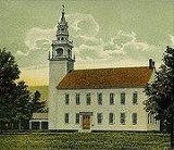
, and designer of the official college seal. The Contoocook River
provided water power for mills. Village prosperity would be expressed in fine early architecture, including the Town Meetinghouse, built in 1775.
Beginning in the 1840s, the area's scenic beauty attracted tourists, and several summer hotels were built at the base of Mount Monadnock
, enduringly popular with hikers. Some who scaled the summit were Ralph Waldo Emerson
, Henry David Thoreau
and Rudyard Kipling
. The experience inspired Emerson in 1845 to write the poem, Monadnoc.
Jaffrey was the setting for a 1950 biography by Elizabeth Yates entitled Amos Fortune, Free Man, winner of the 1951 Newbery Medal
. Amos Fortune
was an African-born slave who purchased his freedom and that of his wife, and established a tannery
in the village. He is buried in the local cemetery, together with bandbox craftswoman Hannah Davis, and author and summer resident Willa Cather
.
Jaffrey was the inspiration for a chapter in Parliament of Whores
by PJ O'Rourke, who was a resident for several years.
, the town has a total area of 40 square miles (103.6 km²), of which 38.3 sq mi (99.2 km²) is land and 1.7 sq mi (4.4 km²) is water, comprising 4.32% of the town. The town center, or census-designated place
, has a total area of 2.6 sq mi (6.7 km²). 2.5 sq mi (6.5 km²) of it is land and 0.1 sq mi (0.258998811 km²) (3.83%) is water.
Thorndike Pond
is in the north, and Contoocook Lake
is on the southern boundary. Mount Monadnock
, elevation 3165 feet (964.7 m) above sea level and the highest point in Jaffrey, is in the northwest. Jaffrey lies mostly within the Merrimack River
watershed
, via the Contoocook River
in the eastern part of the town, with the northwest corner of town lying in the Ashuelot River
watershed, part of the larger Connecticut River
watershed.
Located in southeast Cheshire County
, the town of Jaffrey is bordered by Dublin
to the north, Peterborough
and Sharon
to the east (both part of Hillsborough County
), Rindge
to the south, and Troy
and Marlborough
to the west.
or Latino of any race.
There were 2,120 households out of which 33.8% had children under the age of 18 living with them, 52.7% were married couples living together, 11.3% have a woman whose husband does not live with her, and 30.9% were non-families. 24.4% of all households were made up of individuals and 8.3% had someone living alone who was 65 years of age or older. The average household size was 2.50 and the average family size was 2.98.
In the town the population was spread out with 26.0% under the age of 18, 6.9% from 18 to 24, 28.7% from 25 to 44, 22.7% from 45 to 64, and 15.7% who were 65 years of age or older. The median age was 38 years. For every 100 females there were 92.2 males. For every 100 females age 18 and over, there were 87.3 males.
The median income for a household in the town was $45,033, and the median income for a family was $48,703. Males had a median income of $35,349 versus $26,773 for females. The per capita income for the town was $21,412. 7.8% of the population and 3.8% of families were below the poverty line. Out of the total people living in poverty, 10.2% are under the age of 18 and 10.0% are 65 or older.
. The population density was 1,114.2 people per square mile (431.0/km²). There were 1,217 housing units at an average density of 187.2 persons/km² (483.9 persons/sq mi). The racial makeup of the town was 97.39% White, 0.29% African American, 0.25% Native American, 0.68% Asian, and 1.39% from two or more races. 0.64% of the population were Hispanic
or Latino of any race.
There were 1,157 households out of which 32.8% had children under the age of 18 living with them, 43.8% were married couples living together, 13.4% have a woman whose husband does not live with her, and 36.9% were non-families. 30.1% of all households were made up of individuals and 9.8% had someone living alone who was 65 years of age or older. The average household size was 2.41 and the average family size was 3.01.
In the CDP the population was spread out with 27.1% under the age of 18, 9.3% from 18 to 24, 30.2% from 25 to 44, 20.9% from 45 to 64, and 12.5% who were 65 years of age or older. The median age was 35 years. For every 100 females there were 96.4 males. For every 100 females age 18 and over, there were 91.9 males.
The median income for a household is $35,880, and the median income for a family was $45,343. Males had a median income of $29,606 versus $26,833 for females. The per capita income for the town was $17,781. 10.8% of the population and 5.0% of families were below the poverty line. Out of the total people living in poverty, 12.8% are under the age of 18 and 10.2% are 65 or older.
, forms the Jaffrey-Rindge Cooperative School District, also known as SAU 47. The public schools in the town are Jaffrey Grade School (grades K–5), Jaffrey-Rindge Middle School (6–8), and Conant High School (9–12). There is also a parochial school, St. Patrick School (K–8), as well as a private high school, Victory High School (9–12).
An upgraded town wastewater treatment plant due to come online in 2009 will bring new challenges. One way to defray the high cost of the new plant without excessive increases in the rate structure will be to increase the number of sewer users. This potential strategy will be limited, however, by the town's expressed desire to maintain a compact development pattern around the existing town population centers. In order to accommodate these disparate goals, the primary strategic task facing the town in the upcoming years will be to plan for population density levels and patterns within the town that optimize both livability and economic viability.
New England town
The New England town is the basic unit of local government in each of the six New England states. Without a direct counterpart in most other U.S. states, New England towns are conceptually similar to civil townships in other states, but are incorporated, possessing powers like cities in other...
in Cheshire County
Cheshire County, New Hampshire
-Demographics:As of the census of 2000, there were 73,825 people, 28,299 households, and 18,790 families residing in the county. The population density was 104 people per square mile . There were 31,876 housing units at an average density of 45 per square mile...
, New Hampshire, United States. The population was 5,457 at the 2010 census.
The primary settlement in town, where 2,757 people resided at the 2010 census, is defined as the Jaffrey census-designated place
Census-designated place
A census-designated place is a concentration of population identified by the United States Census Bureau for statistical purposes. CDPs are delineated for each decennial census as the statistical counterparts of incorporated places such as cities, towns and villages...
(CDP) and is located along the Contoocook River
Contoocook River
The Contoocook River is a river in New Hampshire. It flows from Pool Pond and Contoocook Lake on the Jaffrey/Rindge border to Penacook , where it empties into the Merrimack River. It is one of only a few rivers in New Hampshire that flow in a predominantly northward direction...
at the junction of U.S. Route 202
U.S. Route 202
U.S. Route 202 is a highway stretching from Delaware to Maine, also passing through the states of Pennsylvania, New Jersey, New York, Connecticut, Massachusetts, and New Hampshire....
and New Hampshire routes 124
New Hampshire Route 124
New Hampshire Route 124 is a long east–west highway in southern New Hampshire. It runs from Marlborough to the Massachusetts border....
and 137
New Hampshire Route 137
New Hampshire Route 137 is a long secondary north–south state highway in southern New Hampshire. The road runs between Jaffrey and Hancock....
.
History
First granted by the Massachusetts General CourtMassachusetts General Court
The Massachusetts General Court is the state legislature of the Commonwealth of Massachusetts. The name "General Court" is a hold-over from the Colonial Era, when this body also sat in judgment of judicial appeals cases...
in 1736 to soldiers from Rowley, Massachusetts
Rowley, Massachusetts
Rowley is a town in Essex County, Massachusetts, United States. The population was 5,500 at the 2000 census.Part of the town comprises the census-designated place of Rowley.-History:...
, returning from the war in Canada, the town was known as Rowley-Canada. In 1749, the town was re-chartered by the Mason proprietors as Monadnock No. 2, sometimes called Middle Monadnock or Middletown. It was one of the first towns established following the Masonian proprietors' purchase of undivided lands under the claim.
Settled about 1758, the town was regranted in 1767. It would be incorporated in 1773 by Governor John Wentworth
John Wentworth (governor)
Sir John Wentworth, 1st Baronet was the British colonial governor of New Hampshire at the time of the American Revolution. He was later also Lieutenant-Governor of Nova Scotia.-Early life:...
, and named for George Jaffrey, member of a wealthy Portsmouth
Portsmouth, New Hampshire
Portsmouth is a city in Rockingham County, New Hampshire in the United States. It is the largest city but only the fourth-largest community in the county, with a population of 21,233 at the 2010 census...
family. Jaffrey's son was a life trustee of Dartmouth College
Dartmouth College
Dartmouth College is a private, Ivy League university in Hanover, New Hampshire, United States. The institution comprises a liberal arts college, Dartmouth Medical School, Thayer School of Engineering, and the Tuck School of Business, as well as 19 graduate programs in the arts and sciences...
, and designer of the official college seal. The Contoocook River
Contoocook River
The Contoocook River is a river in New Hampshire. It flows from Pool Pond and Contoocook Lake on the Jaffrey/Rindge border to Penacook , where it empties into the Merrimack River. It is one of only a few rivers in New Hampshire that flow in a predominantly northward direction...
provided water power for mills. Village prosperity would be expressed in fine early architecture, including the Town Meetinghouse, built in 1775.
Beginning in the 1840s, the area's scenic beauty attracted tourists, and several summer hotels were built at the base of Mount Monadnock
Mount Monadnock
Mount Monadnock, or Grand Monadnock, is the most prominent New England mountain peak south of the White Mountains and east of the Massachusetts Berkshires, and is the highest point in Cheshire County, New Hampshire...
, enduringly popular with hikers. Some who scaled the summit were Ralph Waldo Emerson
Ralph Waldo Emerson
Ralph Waldo Emerson was an American essayist, lecturer, and poet, who led the Transcendentalist movement of the mid-19th century...
, Henry David Thoreau
Henry David Thoreau
Henry David Thoreau was an American author, poet, philosopher, abolitionist, naturalist, tax resister, development critic, surveyor, historian, and leading transcendentalist...
and Rudyard Kipling
Rudyard Kipling
Joseph Rudyard Kipling was an English poet, short-story writer, and novelist chiefly remembered for his celebration of British imperialism, tales and poems of British soldiers in India, and his tales for children. Kipling received the 1907 Nobel Prize for Literature...
. The experience inspired Emerson in 1845 to write the poem, Monadnoc.
Jaffrey was the setting for a 1950 biography by Elizabeth Yates entitled Amos Fortune, Free Man, winner of the 1951 Newbery Medal
Newbery Medal
The John Newbery Medal is a literary award given by the Association for Library Service to Children, a division of the American Library Association . The award is given to the author of the most distinguished contribution to American literature for children. The award has been given since 1922. ...
. Amos Fortune
Amos Fortune (Citizen of Jaffrey)
Amos Fortune was a prominent African-American citizen of Jaffrey, New Hampshire in the 18th century. Born free in Africa and brought to America as a slave, Fortune purchased his freedom at the age of sixty and moved to Jaffrey to start a tanning business...
was an African-born slave who purchased his freedom and that of his wife, and established a tannery
Tanning
Tanning is the making of leather from the skins of animals which does not easily decompose. Traditionally, tanning used tannin, an acidic chemical compound from which the tanning process draws its name . Coloring may occur during tanning...
in the village. He is buried in the local cemetery, together with bandbox craftswoman Hannah Davis, and author and summer resident Willa Cather
Willa Cather
Willa Seibert Cather was an American author who achieved recognition for her novels of frontier life on the Great Plains, in works such as O Pioneers!, My Ántonia, and The Song of the Lark. In 1923 she was awarded the Pulitzer Prize for One of Ours , a novel set during World War I...
.
Jaffrey was the inspiration for a chapter in Parliament of Whores
Parliament of Whores
Parliament of Whores is an international best-selling political humor book by P. J. O'Rourke published by Atlantic Monthly Press in 1991. Subtitled "A Lone Humorist Attempts to Explain the Entire US Government", Parliament is a scathing critique of the American system of governance from a right...
by PJ O'Rourke, who was a resident for several years.
Geography
According to the United States Census BureauUnited States Census Bureau
The United States Census Bureau is the government agency that is responsible for the United States Census. It also gathers other national demographic and economic data...
, the town has a total area of 40 square miles (103.6 km²), of which 38.3 sq mi (99.2 km²) is land and 1.7 sq mi (4.4 km²) is water, comprising 4.32% of the town. The town center, or census-designated place
Census-designated place
A census-designated place is a concentration of population identified by the United States Census Bureau for statistical purposes. CDPs are delineated for each decennial census as the statistical counterparts of incorporated places such as cities, towns and villages...
, has a total area of 2.6 sq mi (6.7 km²). 2.5 sq mi (6.5 km²) of it is land and 0.1 sq mi (0.258998811 km²) (3.83%) is water.
Thorndike Pond
Thorndike Pond
Thorndike Pond is a water body located in Cheshire County in southwestern New Hampshire, in the towns of Jaffrey and Dublin. The pond is located at the base of Mount Monadnock...
is in the north, and Contoocook Lake
Contoocook Lake
Contoocook Lake is a water body located in Cheshire County in southwestern New Hampshire, United States, in the towns of Jaffrey and Rindge. The lake, along with Pool Pond, forms the headwaters of the Contoocook River, which flows north to the Merrimack River in Penacook, New Hampshire.Contoocook...
is on the southern boundary. Mount Monadnock
Mount Monadnock
Mount Monadnock, or Grand Monadnock, is the most prominent New England mountain peak south of the White Mountains and east of the Massachusetts Berkshires, and is the highest point in Cheshire County, New Hampshire...
, elevation 3165 feet (964.7 m) above sea level and the highest point in Jaffrey, is in the northwest. Jaffrey lies mostly within the Merrimack River
Merrimack River
The Merrimack River is a river in the northeastern United States. It rises at the confluence of the Pemigewasset and Winnipesaukee rivers in Franklin, New Hampshire, flows southward into Massachusetts, and then flows northeast until it empties into the Atlantic Ocean at Newburyport...
watershed
Drainage basin
A drainage basin is an extent or an area of land where surface water from rain and melting snow or ice converges to a single point, usually the exit of the basin, where the waters join another waterbody, such as a river, lake, reservoir, estuary, wetland, sea, or ocean...
, via the Contoocook River
Contoocook River
The Contoocook River is a river in New Hampshire. It flows from Pool Pond and Contoocook Lake on the Jaffrey/Rindge border to Penacook , where it empties into the Merrimack River. It is one of only a few rivers in New Hampshire that flow in a predominantly northward direction...
in the eastern part of the town, with the northwest corner of town lying in the Ashuelot River
Ashuelot River
The Ashuelot River is a tributary of the Connecticut River, approximately long, in southwestern New Hampshire in the United States. It drains a mountainous area of , including much of the area known as the Monadnock Region...
watershed, part of the larger Connecticut River
Connecticut River
The Connecticut River is the largest and longest river in New England, and also an American Heritage River. It flows roughly south, starting from the Fourth Connecticut Lake in New Hampshire. After flowing through the remaining Connecticut Lakes and Lake Francis, it defines the border between the...
watershed.
Located in southeast Cheshire County
Cheshire County, New Hampshire
-Demographics:As of the census of 2000, there were 73,825 people, 28,299 households, and 18,790 families residing in the county. The population density was 104 people per square mile . There were 31,876 housing units at an average density of 45 per square mile...
, the town of Jaffrey is bordered by Dublin
Dublin, New Hampshire
Dublin is a town in Cheshire County, New Hampshire, United States. The population was 1,597 at the 2010 census. It is home to both the Dublin School and Yankee Magazine.-History:...
to the north, Peterborough
Peterborough, New Hampshire
Peterborough is a town in Hillsborough County, New Hampshire, United States. The population was 6,284 at the 2010 census. Home to the MacDowell Art Colony, the town is a popular tourist destination....
and Sharon
Sharon, New Hampshire
Sharon is a town in Hillsborough County, New Hampshire, United States. The population was 352 at the 2010 census.-History:Settled in 1738, Sharon was originally a part of Peterborough...
to the east (both part of Hillsborough County
Hillsborough County, New Hampshire
-Demographics:As of the census of 2000, there were 380,841 people, 144,455 households, and 98,807 families residing in the county. The population density was 435 people per square mile . There were 149,961 housing units at an average density of 171 per square mile...
), Rindge
Rindge, New Hampshire
Rindge is a town in Cheshire County, New Hampshire, United States. The population was 6,014 at the 2010 census. Rindge is home to Franklin Pierce University, the Cathedral of the Pines, and part of Annett State Forest.-Native American inhabitants:...
to the south, and Troy
Troy, New Hampshire
Troy is a town in Cheshire County, New Hampshire, United States. The population was 2,145 at the 2010 census. It is situated at the base of Mount Monadnock....
and Marlborough
Marlborough, New Hampshire
Marlborough is a town in Cheshire County, New Hampshire, United States. The population was 2,063 at the 2010 census. The town is home to the Kensan-Devan Wildlife Sanctuary at Meetinghouse Pond....
to the west.
Demographics
As of the census of 2000, there were 5,476 people, 2,120 households, and 1,464 families residing in the town. The population density was 143.0 people per square mile (55.2/km²). There were 2,352 housing units at an average density of 23.7 persons/km² (61.4 persons/sq mi). The racial makeup of the town was 97.32% White, 0.42% African American, 0.35% Native American, 0.69% Asian, 0.00% Pacific Islander, 0.04% from other races, and 1.19% from two or more races. 0.57% of the population were HispanicHispanic
Hispanic is a term that originally denoted a relationship to Hispania, which is to say the Iberian Peninsula: Andorra, Gibraltar, Portugal and Spain. During the Modern Era, Hispanic sometimes takes on a more limited meaning, particularly in the United States, where the term means a person of ...
or Latino of any race.
There were 2,120 households out of which 33.8% had children under the age of 18 living with them, 52.7% were married couples living together, 11.3% have a woman whose husband does not live with her, and 30.9% were non-families. 24.4% of all households were made up of individuals and 8.3% had someone living alone who was 65 years of age or older. The average household size was 2.50 and the average family size was 2.98.
In the town the population was spread out with 26.0% under the age of 18, 6.9% from 18 to 24, 28.7% from 25 to 44, 22.7% from 45 to 64, and 15.7% who were 65 years of age or older. The median age was 38 years. For every 100 females there were 92.2 males. For every 100 females age 18 and over, there were 87.3 males.
The median income for a household in the town was $45,033, and the median income for a family was $48,703. Males had a median income of $35,349 versus $26,773 for females. The per capita income for the town was $21,412. 7.8% of the population and 3.8% of families were below the poverty line. Out of the total people living in poverty, 10.2% are under the age of 18 and 10.0% are 65 or older.
Town center
As of the census of 2000, there were 2,802 people, 1,157 households, and 730 families residing in the town center, or census-designated placeCensus-designated place
A census-designated place is a concentration of population identified by the United States Census Bureau for statistical purposes. CDPs are delineated for each decennial census as the statistical counterparts of incorporated places such as cities, towns and villages...
. The population density was 1,114.2 people per square mile (431.0/km²). There were 1,217 housing units at an average density of 187.2 persons/km² (483.9 persons/sq mi). The racial makeup of the town was 97.39% White, 0.29% African American, 0.25% Native American, 0.68% Asian, and 1.39% from two or more races. 0.64% of the population were Hispanic
Hispanic
Hispanic is a term that originally denoted a relationship to Hispania, which is to say the Iberian Peninsula: Andorra, Gibraltar, Portugal and Spain. During the Modern Era, Hispanic sometimes takes on a more limited meaning, particularly in the United States, where the term means a person of ...
or Latino of any race.
There were 1,157 households out of which 32.8% had children under the age of 18 living with them, 43.8% were married couples living together, 13.4% have a woman whose husband does not live with her, and 36.9% were non-families. 30.1% of all households were made up of individuals and 9.8% had someone living alone who was 65 years of age or older. The average household size was 2.41 and the average family size was 3.01.
In the CDP the population was spread out with 27.1% under the age of 18, 9.3% from 18 to 24, 30.2% from 25 to 44, 20.9% from 45 to 64, and 12.5% who were 65 years of age or older. The median age was 35 years. For every 100 females there were 96.4 males. For every 100 females age 18 and over, there were 91.9 males.
The median income for a household is $35,880, and the median income for a family was $45,343. Males had a median income of $29,606 versus $26,833 for females. The per capita income for the town was $17,781. 10.8% of the population and 5.0% of families were below the poverty line. Out of the total people living in poverty, 12.8% are under the age of 18 and 10.2% are 65 or older.
School system
Jaffrey, along with the town of RindgeRindge, New Hampshire
Rindge is a town in Cheshire County, New Hampshire, United States. The population was 6,014 at the 2010 census. Rindge is home to Franklin Pierce University, the Cathedral of the Pines, and part of Annett State Forest.-Native American inhabitants:...
, forms the Jaffrey-Rindge Cooperative School District, also known as SAU 47. The public schools in the town are Jaffrey Grade School (grades K–5), Jaffrey-Rindge Middle School (6–8), and Conant High School (9–12). There is also a parochial school, St. Patrick School (K–8), as well as a private high school, Victory High School (9–12).
Master plan
As with many small rural towns in New England, Jaffrey enters the 21st century grappling with the issues of how to cope with increased population growth and development pressures. Both for tourism and for quality of life of its residents, open undeveloped land is an important component of the town's attractions. In the 2007 update to its Master Plan, the town specifically cites a desire to preserve open space and rural character. The challenge facing the town, however, is how to accomplish this goal while still providing for the economic and housing growth that will ensure the long-term viability of the community.An upgraded town wastewater treatment plant due to come online in 2009 will bring new challenges. One way to defray the high cost of the new plant without excessive increases in the rate structure will be to increase the number of sewer users. This potential strategy will be limited, however, by the town's expressed desire to maintain a compact development pattern around the existing town population centers. In order to accommodate these disparate goals, the primary strategic task facing the town in the upcoming years will be to plan for population density levels and patterns within the town that optimize both livability and economic viability.