
Mount Le Conte
Encyclopedia
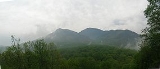
Mount Le Conte is a mountain
in Sevier County, Tennessee
located within the Great Smoky Mountains National Park
. At 6593 ft (2,010 m) it is the third highest peak in the national park, behind Clingmans Dome
(6,643 ft, 2,024 m) and Mount Guyot
(6,621 ft, 2,018 m). However, from its immediate base to its highest peak, Mount Le Conte is the tallest mountain in Tennessee
, rising 5,301 ft (1,616 m) from its base, near Gatlinburg, Tennessee
(1,292 ft/394 m).
There are four subpeaks above 6,000 ft on the mountain (referred to as the LeConte massif
): West Point (6,344 ft/1,934 m), High Top (6,593 ft/2,010 m), Cliff Tops (6,555 ft/1,998 m), and Myrtle Point (6,200 ft/1,890 m). In addition, Balsam Point (5,840+ ft/1,780+ m) serves as the dramatic west end of the massif. Additionally, the mountain is notable for having the highest inn providing lodging for visitors in the Eastern United States.
lists Joseph Le Conte, famous geologist, as the man for whom the mountain was named, supposedly by Swiss explorer Arnold Guyot . However, in recent years this claim has been challenged by local authorities (including the authors of A Natural History of Mount Le Conte), who in turn believe that the mountain derives its name from Joseph's older — and less famous — brother John Le Conte
, a physicist at South Carolina College.http://www.georgiaencyclopedia.org/nge/Article.jsp?id=h-791 Their story alleges that the mountain was named by Samuel Buckley in respect to John's help in moving his barometer to Waynesville, North Carolina
, at Buckley's request.http://www.gsmit.org/downloads/newsspring2004.pdf
Although the mountain was measured in the 1850s, very little activity took place on the mountain until the 1920s, when Paul Adams moved to Knoxville, Tennessee
. An enthusiastic hiker and explorer, Adams spent much of his free time creating adventures in the mountains. In 1924 he joined the Great Smoky Mountain Conservation Association, a group dedicated to making the region into a national park. As part of this push, later that year he led an expedition up the mountain with dignitaries from Washington, in order to show the group what rugged beauty those mountains held. The group spent the night in a large tent which would later become a cabin, and eventually the LeConte Lodge, a popular resort near the top of the peak. The trip was a great success and about a decade later Mount Le Conte, and the surrounding region, was protected as part of the Great Smoky Mountains National Park.
geologic and physiographic province. It is made up of Late Proterozoic rocks; mostly metamorphosed sandstone
, siltstone
, shale
, and conglomerate
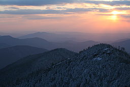
formed over 800–450 million years ago. Millions of years of weathering has caused significant erosion, giving the mountains in the region, including Le Conte, a distinctive, gentle sloping feature. A dense stand of Southern Appalachian spruce-fir forest
, a remnant of the last Ice Age
, coats the mountain's peaks and upper slopes.
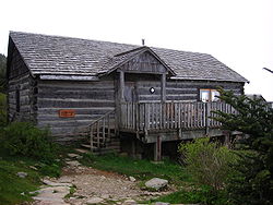 Mount Le Conte is notable for having the highest inn
providing lodging
for visitors in the Eastern United States. The LeConte Lodge is a small resort, established in 1925, located on the top of the mountain. First, it was a tent, then a single cabin, and now it is a series of small personal log cabins and a central lodge/dining hall situated along the top of a mountain. It can accommodate about 50 guests a night, and is generally open from March–November. There is no transportation to the lodge and all guests must hike in on one of the five trails that access the mountain. Due to this lack of access, supplies must be brought in via helicopter and llama pack trains. The climate at the lodge is similar to that found in southern Canada, with cool summers (no temperature above 80°F (29 degrees C) has ever been recorded at the lodge) and cold, snowy winters. Currently, the lodge is maintained under a lease with the National Park Service. The lodge is quite popular, with prospective guests sometimes having to book reservations over a year in advance.
 Le Conte's location in the Great Smoky Mountains National Park has spurred the creation of five trails that lead to the LeConte Lodge, with spur trails to each of the individual peaks. In addition to the scenic overlooks and peaceful woodlands endemic to each path, every trail offers its own unique attractions along the way to the summit. They are listed with their distances one-way as follows
The combined traffic of these five trails makes Mount Le Conte one of the most heavily-traversed mountains in the park. The Alum Cave and Rainbow Falls trails in particular tend to become overcrowded with visitors seeking rewarding payoffs just a few miles into the trails. Hikers can stay in an Appalachian Trail
style shelter overnight for free with a backcountry
permit and reservations from the National Park Service
.
Mountain
Image:Himalaya_annotated.jpg|thumb|right|The Himalayan mountain range with Mount Everestrect 58 14 160 49 Chomo Lonzorect 200 28 335 52 Makalurect 378 24 566 45 Mount Everestrect 188 581 920 656 Tibetan Plateaurect 250 406 340 427 Rong River...
in Sevier County, Tennessee
Sevier County, Tennessee
Sevier County is a county of the state of Tennessee, United States. Its population was 71,170 at the 2000 United States Census. It is included in the Sevierville, Tennessee, Micropolitan Statistical Area, which is included in the Knoxville-Sevierville-La Follette, TN Combined Statistical Area. The...
located within the Great Smoky Mountains National Park
Great Smoky Mountains National Park
Great Smoky Mountains National Park is a United States National Park and UNESCO World Heritage Site that straddles the ridgeline of the Great Smoky Mountains, part of the Blue Ridge Mountains, which are a division of the larger Appalachian Mountain chain. The border between Tennessee and North...
. At 6593 ft (2,010 m) it is the third highest peak in the national park, behind Clingmans Dome
Clingmans Dome
Clingmans Dome is a mountain in the Great Smoky Mountains of Tennessee and North Carolina, in the southeastern United States. At an elevation of , it is the highest mountain in the Smokies, the highest point in the state of Tennessee, and the highest point along the Appalachian Trail...
(6,643 ft, 2,024 m) and Mount Guyot
Mount Guyot (Great Smoky Mountains)
Mount Guyot is a mountain in the eastern Great Smoky Mountains, located inthe southeastern United States. At above sea level, Guyot is the fourth-highestsummit in the eastern U.S., and the second-highest in the Great Smoky Mountains National Park...
(6,621 ft, 2,018 m). However, from its immediate base to its highest peak, Mount Le Conte is the tallest mountain in Tennessee
Tennessee
Tennessee is a U.S. state located in the Southeastern United States. It has a population of 6,346,105, making it the nation's 17th-largest state by population, and covers , making it the 36th-largest by total land area...
, rising 5,301 ft (1,616 m) from its base, near Gatlinburg, Tennessee
Gatlinburg, Tennessee
Gatlinburg is a mountain resort city in Sevier County, Tennessee, United States. As of the 2000 U.S. Census, Gatlinburg had a population of 3,828. The city is a popular vacation resort, as it rests on the border of the Great Smoky Mountains National Park along U.S...
(1,292 ft/394 m).
There are four subpeaks above 6,000 ft on the mountain (referred to as the LeConte massif
Massif
In geology, a massif is a section of a planet's crust that is demarcated by faults or flexures. In the movement of the crust, a massif tends to retain its internal structure while being displaced as a whole...
): West Point (6,344 ft/1,934 m), High Top (6,593 ft/2,010 m), Cliff Tops (6,555 ft/1,998 m), and Myrtle Point (6,200 ft/1,890 m). In addition, Balsam Point (5,840+ ft/1,780+ m) serves as the dramatic west end of the massif. Additionally, the mountain is notable for having the highest inn providing lodging for visitors in the Eastern United States.
History
There is considerable controversy over just which member of the Le Conte family the mountain was named for. The United States Geological SurveyUnited States Geological Survey
The United States Geological Survey is a scientific agency of the United States government. The scientists of the USGS study the landscape of the United States, its natural resources, and the natural hazards that threaten it. The organization has four major science disciplines, concerning biology,...
lists Joseph Le Conte, famous geologist, as the man for whom the mountain was named, supposedly by Swiss explorer Arnold Guyot . However, in recent years this claim has been challenged by local authorities (including the authors of A Natural History of Mount Le Conte), who in turn believe that the mountain derives its name from Joseph's older — and less famous — brother John Le Conte
John Le Conte
John Le Conte was an American scientist and academic. He served as President of the University of California, Berkeley.-Biography:...
, a physicist at South Carolina College.http://www.georgiaencyclopedia.org/nge/Article.jsp?id=h-791 Their story alleges that the mountain was named by Samuel Buckley in respect to John's help in moving his barometer to Waynesville, North Carolina
Waynesville, North Carolina
Waynesville is a town in and the county seat of Haywood County, North Carolina, United States. It is the largest town in Haywood County and the largest in Western North Carolina west of Asheville. Waynesville is located about or 50 km southwest of Asheville between the Great Smoky and Blue...
, at Buckley's request.http://www.gsmit.org/downloads/newsspring2004.pdf
Although the mountain was measured in the 1850s, very little activity took place on the mountain until the 1920s, when Paul Adams moved to Knoxville, Tennessee
Knoxville, Tennessee
Founded in 1786, Knoxville is the third-largest city in the U.S. state of Tennessee, U.S.A., behind Memphis and Nashville, and is the county seat of Knox County. It is the largest city in East Tennessee, and the second-largest city in the Appalachia region...
. An enthusiastic hiker and explorer, Adams spent much of his free time creating adventures in the mountains. In 1924 he joined the Great Smoky Mountain Conservation Association, a group dedicated to making the region into a national park. As part of this push, later that year he led an expedition up the mountain with dignitaries from Washington, in order to show the group what rugged beauty those mountains held. The group spent the night in a large tent which would later become a cabin, and eventually the LeConte Lodge, a popular resort near the top of the peak. The trip was a great success and about a decade later Mount Le Conte, and the surrounding region, was protected as part of the Great Smoky Mountains National Park.
Geology
Mount Le Conte lies in the Appalachian Blue RidgeBlue Ridge Mountains
The Blue Ridge Mountains are a physiographic province of the larger Appalachian Mountains range. This province consists of northern and southern physiographic regions, which divide near the Roanoke River gap. The mountain range is located in the eastern United States, starting at its southern-most...
geologic and physiographic province. It is made up of Late Proterozoic rocks; mostly metamorphosed sandstone
Sandstone
Sandstone is a sedimentary rock composed mainly of sand-sized minerals or rock grains.Most sandstone is composed of quartz and/or feldspar because these are the most common minerals in the Earth's crust. Like sand, sandstone may be any colour, but the most common colours are tan, brown, yellow,...
, siltstone
Siltstone
Siltstone is a sedimentary rock which has a grain size in the silt range, finer than sandstone and coarser than claystones.- Description :As its name implies, it is primarily composed of silt sized particles, defined as grains 1/16 - 1/256 mm or 4 to 8 on the Krumbein phi scale...
, shale
Shale
Shale is a fine-grained, clastic sedimentary rock composed of mud that is a mix of flakes of clay minerals and tiny fragments of other minerals, especially quartz and calcite. The ratio of clay to other minerals is variable. Shale is characterized by breaks along thin laminae or parallel layering...
, and conglomerate
Conglomerate (geology)
A conglomerate is a rock consisting of individual clasts within a finer-grained matrix that have become cemented together. Conglomerates are sedimentary rocks consisting of rounded fragments and are thus differentiated from breccias, which consist of angular clasts...
formed over 800–450 million years ago. Millions of years of weathering has caused significant erosion, giving the mountains in the region, including Le Conte, a distinctive, gentle sloping feature. A dense stand of Southern Appalachian spruce-fir forest
Southern Appalachian spruce-fir forest
The Southern Appalachian spruce-fir forest is a type of montane coniferous forest that grows in the highest elevations in the southern Appalachian Mountains of the eastern United States...
, a remnant of the last Ice Age
Ice age
An ice age or, more precisely, glacial age, is a generic geological period of long-term reduction in the temperature of the Earth's surface and atmosphere, resulting in the presence or expansion of continental ice sheets, polar ice sheets and alpine glaciers...
, coats the mountain's peaks and upper slopes.
Climate
Mount Le Conte has a climate similar to that of Southern Canada, giving it cool summers, and cold snowy winters. Snowfall averages 39.43 inches near the base to 71.82 inches on the highest peak. The climate is much cooler and somewhat wetter than the lower elevations. The lowest temperature was -32 on January 13, 1986. It was believed to reach 85 degrees on July 25, 2010, however that reading was in the sun and was not accurate, it only reached 76 degrees that day.LeConte Lodge
INN
InterNetNews is a Usenet news server package, originally released by Rich Salz in 1991, and presented at the Summer 1992 USENIX conference in San Antonio, Texas...
providing lodging
Lodging
Lodging is a type of residential accommodation. People who travel and stay away from home for more than a day need lodging for sleep, rest, safety, shelter from cold temperatures or rain, storage of luggage and access to common household functions.Lodgings may be self catering in which case no...
for visitors in the Eastern United States. The LeConte Lodge is a small resort, established in 1925, located on the top of the mountain. First, it was a tent, then a single cabin, and now it is a series of small personal log cabins and a central lodge/dining hall situated along the top of a mountain. It can accommodate about 50 guests a night, and is generally open from March–November. There is no transportation to the lodge and all guests must hike in on one of the five trails that access the mountain. Due to this lack of access, supplies must be brought in via helicopter and llama pack trains. The climate at the lodge is similar to that found in southern Canada, with cool summers (no temperature above 80°F (29 degrees C) has ever been recorded at the lodge) and cold, snowy winters. Currently, the lodge is maintained under a lease with the National Park Service. The lodge is quite popular, with prospective guests sometimes having to book reservations over a year in advance.
Access
- Alum Cave TrailAlum Cave TrailThe Alum Cave Trail is an American hiking trail in the Great Smoky Mountains National Park, in Sevier County, Tennessee. The trail ascends Mount Le Conte, the tallest mountain east of the Mississippi River and contains many notable landmarks before merging into the Rainbow Falls Trail, near...
— 4.9 miles (8.0 km); Alum Cave Creek, Arch Rock, Alum Cave Bluff and views into Huggins Hell decorate the trail; it is both the most scenic and often used trail. - The Boulevard TrailThe Boulevard TrailThe Boulevard Trail is an American hiking trail in the Great Smoky Mountains National Park, in Sevier County, Tennessee. The trail ascends Mount Le Conte, the tallest mountain east of the Mississippi River and offers outstanding high-elevation views before terminating near the LeConte...
— 5.4 miles (8.7 km) (8.0 miles from Newfound Gap); Begins on the crest of the Great Smoky Mountains 2.7 miles east of Newfound Gap on the Appalachian Trail; it never dips below 5,500 ft (1,676 m). - Bullhead TrailBullhead TrailThe Bullhead Trail is an American hiking trail in the Great Smoky Mountains National Park, in Sevier County, Tennessee. The trail ascends Mount Le Conte, the tallest mountain east of the Mississippi River and offers outstanding views before joining the Rainbow Falls Trail before terminating...
— 6.9 miles (11.1 km); The least traveled path, it offers the most solitude. - Rainbow Falls TrailRainbow Falls TrailThe Rainbow Falls Trail is an American hiking trail in the Great Smoky Mountains National Park, in Sevier County, Tennessee. The trail ascends Mount Le Conte, the tallest mountain east of the Mississippi River and passes Rainbow Falls before absorbing the Alum Cave Trail and terminating near...
— 6.6 miles (10.6 km); LeConte Creek runs alongside the trail until Rainbow Falls, the single highest drop of water in the national park. - Trillium Gap TrailTrillium Gap TrailThe Trillium Gap Trail is an American hiking trail in the Great Smoky Mountains National Park, in Sevier County, Tennessee. The trail ascends Mount Le Conte, the tallest mountain east of the Mississippi River and passes both Grotto Falls and Trillium Gap before reaching the LeConte Lodge,...
— 8.9 miles (14.3 km); The trail passes behind Grotto Falls, the only opportunity to walk behind a waterfall in the park; Trillium Gap offers spring wildflowers and a short spur hike to Brushy Mountain; the only horse trail on the mountain; the llama trains that supply the lodge use this trail. Starting the Trillium Gap Trail at the Trillium Gap parking lot shortens the climb by 2.4 miles making this a 6.5 mile trail.
The combined traffic of these five trails makes Mount Le Conte one of the most heavily-traversed mountains in the park. The Alum Cave and Rainbow Falls trails in particular tend to become overcrowded with visitors seeking rewarding payoffs just a few miles into the trails. Hikers can stay in an Appalachian Trail
Appalachian Trail
The Appalachian National Scenic Trail, generally known as the Appalachian Trail or simply the AT, is a marked hiking trail in the eastern United States extending between Springer Mountain in Georgia and Mount Katahdin in Maine. It is approximately long...
style shelter overnight for free with a backcountry
Backcountry
A backcountry area in general terms is a geographical region that is:* isolated* remote* undeveloped* difficult to accessThe term may apply to various regions that are reasonably close to urban areas but are:* not immediately accessible by car...
permit and reservations from the National Park Service
National Park Service
The National Park Service is the U.S. federal agency that manages all national parks, many national monuments, and other conservation and historical properties with various title designations...
.