
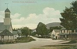
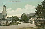
Moultonborough, New Hampshire
Encyclopedia
Moultonborough is a town
in Carroll County
, New Hampshire
, United States
. The population was 4,044 at the 2010 census. Moultonborough is bounded in part by Lake Winnipesaukee
in the southwest and Squam Lake
in the northwest corner. The town includes the census-designated place
of Suissevale
.
 The first settlers were grantees from Hampton
, among whom were at least sixteen Moultons, giving the town its name. Colonel Jonathan Moulton
was considered to be one of the richest men in the province at the start of the American Revolution
. Moultonborough was chartered in 1763 by Colonial
Governor Benning Wentworth
, and at the time was described as being near the "Winnepisseoky Pond." It would be incorporated in 1777.
Moultonborough is home to the "Castle in the Clouds
", an estate set in the Ossipee Mountains
. Thomas Gustave Plant
made a fortune manufacturing shoes, bought 6300 acres (25 km²) and hired the Boston architectural firm of J. Williams Beal & Sons to design "Lucknow," a stone mansion built between 1913 and 1914. The property, with sweeping views of Lake Winnipesaukee, is a popular tourist attraction.
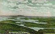
, the town has a total area of 74.6 square miles (193.2 km²), of which 59.5 square miles (154.1 km²) is land and 15.1 square miles (39.1 km²) is water, comprising 20.29% of the town. A large portion of the town is located along Lake Winnipesaukee
, the largest lake in New Hampshire. Moultonborough Bay, an 8 miles (13 km) arm of the lake, extends from the southern corner of the town towards the center of the town. Moultonborough Neck forms a peninsula between Moultonborough Bay and Center Harbor to the southwest. Long Island, the largest island in Lake Winnipesaukee, is connected to Moultonborough Neck by a bridge. The community of Suissevale
, a census-designated place
, occupies part of the northeast shore of Moultonborough Bay. Inland from Winnipesaukee, Lake Kanasatka
is in the west part of the town. Red Hill, elevation 2029 feet (618.4 m) above sea level
, is in the northwest. Mount Shaw
, elevation 2990 feet (911.4 m), part of the Ossipee Mountains and the highest point in Moultonborough, is in the east.
The town center of Moultonborough is located 1 miles (1.6 km) north of the head of Moultonborough Bay, at the intersection of New Hampshire Route 25
and Route 109
. Route 25 is a major east-west highway in the state connecting Meredith
and Plymouth
to the west with Ossipee, New Hampshire
and Portland, Maine
to the east. Route 109, a local road, proceeds southeast towards Wolfeboro
and northwest to Center Sandwich
.
 As of the census
of 2000, there were 4,484 people, 1,884 households, and 1,377 families residing in the town. The population density
was 74.9 people per square mile (28.9/km²). There were 4,523 housing units at an average density of 75.6 per square mile (29.2/km²). The racial makeup of the town was 98.48% White, 0.13% African American, 0.22% Native American, 0.56% Asian, 0.02% from other races
, and 0.58% from two or more races. Hispanic or Latino of any race were 0.62% of the population.
There were 1,884 households out of which 25.7% had children under the age of 18 living with them, 63.7% were married couples
living together, 6.0% had a female householder with no husband present, and 26.9% were non-families. 23.7% of all households were made up of individuals and 9.8% had someone living alone who was 65 years of age or older. The average household size was 2.36 and the average family size was 2.77.
In the town the population was spread out with 21.1% under the age of 18, 4.1% from 18 to 24, 22.3% from 25 to 44, 32.6% from 45 to 64, and 19.9% who were 65 years of age or older. The median age was 47 years. For every 100 females there were 97.6 males. For every 100 females age 18 and over, there were 96.6 males.
The median income for a household in the town was $45,050, and the median income for a family was $51,729. Males had a median income of $34,236 versus $25,332 for females. The per capita income
for the town was $25,733. About 3.2% of families and 4.0% of the population were below the poverty line, including 3.3% of those under age 18 and 2.6% of those age 65 or over.
is the local middle and high school, educating students in grades seven through twelve. The school is located off Blake Road just south of the village of Moultonborough. The Moultonborough Central School, which is located on NH Route 25
near the academy, serves grades K-6. The Moultonborough School District serves only the town of Moultonborough.
New England town
The New England town is the basic unit of local government in each of the six New England states. Without a direct counterpart in most other U.S. states, New England towns are conceptually similar to civil townships in other states, but are incorporated, possessing powers like cities in other...
in Carroll County
Carroll County, New Hampshire
-Demographics:As of the census of 2000, there were 43,666 people, 18,351 households, and 12,313 families residing in the county. The population density was 18/km² . There were 34,750 housing units at an average density of 14/km²...
, New Hampshire
New Hampshire
New Hampshire is a state in the New England region of the northeastern United States of America. The state was named after the southern English county of Hampshire. It is bordered by Massachusetts to the south, Vermont to the west, Maine and the Atlantic Ocean to the east, and the Canadian...
, United States
United States
The United States of America is a federal constitutional republic comprising fifty states and a federal district...
. The population was 4,044 at the 2010 census. Moultonborough is bounded in part by Lake Winnipesaukee
Lake Winnipesaukee
Lake Winnipesaukee is the largest lake in the U.S. state of New Hampshire. It is approximately long and from wide , covering — when Paugus Bay is included—with a maximum depth of ....
in the southwest and Squam Lake
Squam Lake
Squam Lake is a lake located in central New Hampshire, USA, south of the White Mountains, straddling the borders of Grafton, Carroll, and Belknap counties. The largest town center on the lake is Holderness...
in the northwest corner. The town includes the census-designated place
Census-designated place
A census-designated place is a concentration of population identified by the United States Census Bureau for statistical purposes. CDPs are delineated for each decennial census as the statistical counterparts of incorporated places such as cities, towns and villages...
of Suissevale
Suissevale, New Hampshire
Suissevale is a private subdivision in the town of Moultonborough in Carroll County, New Hampshire. It is located between New Hampshire Route 109 and Moultonborough Bay, an arm of Lake Winnipesaukee. The subdivision was listed as a census-designated place for the 2010 U.S. Census and had a...
.
History
Hampton, New Hampshire
Hampton is a town in Rockingham County, New Hampshire, United States. The population was 14,976 at the 2010 census. Located beside the Atlantic Ocean, Hampton is home to Hampton Beach, a summer tourist destination....
, among whom were at least sixteen Moultons, giving the town its name. Colonel Jonathan Moulton
Jonathan Moulton
General Jonathan Moulton played an important role in the early history of New Hampshire, and many tales of his adventures would become legendary.-Early life and King George's War:...
was considered to be one of the richest men in the province at the start of the American Revolution
American Revolution
The American Revolution was the political upheaval during the last half of the 18th century in which thirteen colonies in North America joined together to break free from the British Empire, combining to become the United States of America...
. Moultonborough was chartered in 1763 by Colonial
Colony
In politics and history, a colony is a territory under the immediate political control of a state. For colonies in antiquity, city-states would often found their own colonies. Some colonies were historically countries, while others were territories without definite statehood from their inception....
Governor Benning Wentworth
Benning Wentworth
Benning Wentworth was the colonial governor of New Hampshire from 1741 to 1766.-Biography:The eldest child of the John Wentworth who had been Lieutenant Governor, he was born and died in Portsmouth, New Hampshire. Wentworth graduated from Harvard College in 1715...
, and at the time was described as being near the "Winnepisseoky Pond." It would be incorporated in 1777.
Moultonborough is home to the "Castle in the Clouds
Castle in the Clouds
Castle in the Clouds is a 16-room mansion and mountaintop estate in Moultonborough, New Hampshire owned by the Lakes Region Conservation Trust and operated by the Castle Preservation Society...
", an estate set in the Ossipee Mountains
Ossipee Mountains
The Ossipee Mountains are located just south of the White Mountains of New Hampshire, United States. Mount Shaw, at , is the highest point in the range.-Geology and physiography:...
. Thomas Gustave Plant
Thomas Gustave Plant
Thomas Gustave Plant was a French-Canadian immigrant who made his fortune manufacturing shoes under the Queen Quality Shoes label. His largest shoe factory, the Thomas G. Plant Shoe Factory in Roxbury , Massachusetts, stood at...
made a fortune manufacturing shoes, bought 6300 acres (25 km²) and hired the Boston architectural firm of J. Williams Beal & Sons to design "Lucknow," a stone mansion built between 1913 and 1914. The property, with sweeping views of Lake Winnipesaukee, is a popular tourist attraction.
Notable inhabitants
- Robert FrostRobert FrostRobert Lee Frost was an American poet. He is highly regarded for his realistic depictions of rural life and his command of American colloquial speech. His work frequently employed settings from rural life in New England in the early twentieth century, using them to examine complex social and...
, poet (summer resident) - Colonel Jonathan MoultonJonathan MoultonGeneral Jonathan Moulton played an important role in the early history of New Hampshire, and many tales of his adventures would become legendary.-Early life and King George's War:...
, soldier - Thomas Gustave PlantThomas Gustave PlantThomas Gustave Plant was a French-Canadian immigrant who made his fortune manufacturing shoes under the Queen Quality Shoes label. His largest shoe factory, the Thomas G. Plant Shoe Factory in Roxbury , Massachusetts, stood at...
, industrialist - Claude RainsClaude RainsClaude Rains was an English stage and film actor whose career spanned 66 years. He was known for many roles in Hollywood films, among them the title role in The Invisible Man , a corrupt senator in Mr. Smith Goes to Washington , Mr...
, actor, buried at Red Hill Cemetery - John Greenleaf WhittierJohn Greenleaf WhittierJohn Greenleaf Whittier was an influential American Quaker poet and ardent advocate of the abolition of slavery in the United States. He is usually listed as one of the Fireside Poets...
, poet (summer resident)
Geography
According to the United States Census BureauUnited States Census Bureau
The United States Census Bureau is the government agency that is responsible for the United States Census. It also gathers other national demographic and economic data...
, the town has a total area of 74.6 square miles (193.2 km²), of which 59.5 square miles (154.1 km²) is land and 15.1 square miles (39.1 km²) is water, comprising 20.29% of the town. A large portion of the town is located along Lake Winnipesaukee
Lake Winnipesaukee
Lake Winnipesaukee is the largest lake in the U.S. state of New Hampshire. It is approximately long and from wide , covering — when Paugus Bay is included—with a maximum depth of ....
, the largest lake in New Hampshire. Moultonborough Bay, an 8 miles (13 km) arm of the lake, extends from the southern corner of the town towards the center of the town. Moultonborough Neck forms a peninsula between Moultonborough Bay and Center Harbor to the southwest. Long Island, the largest island in Lake Winnipesaukee, is connected to Moultonborough Neck by a bridge. The community of Suissevale
Suissevale, New Hampshire
Suissevale is a private subdivision in the town of Moultonborough in Carroll County, New Hampshire. It is located between New Hampshire Route 109 and Moultonborough Bay, an arm of Lake Winnipesaukee. The subdivision was listed as a census-designated place for the 2010 U.S. Census and had a...
, a census-designated place
Census-designated place
A census-designated place is a concentration of population identified by the United States Census Bureau for statistical purposes. CDPs are delineated for each decennial census as the statistical counterparts of incorporated places such as cities, towns and villages...
, occupies part of the northeast shore of Moultonborough Bay. Inland from Winnipesaukee, Lake Kanasatka
Lake Kanasatka
Lake Kanasatka is a lake located in Carroll County in the Lakes Region of central New Hampshire, United States, in the town of Moultonborough. Early maps refer to this pristine lake as Long Pond, presumably because of its long and narrow shape. The lake is located one-half mile north of and nine...
is in the west part of the town. Red Hill, elevation 2029 feet (618.4 m) above sea level
Sea level
Mean sea level is a measure of the average height of the ocean's surface ; used as a standard in reckoning land elevation...
, is in the northwest. Mount Shaw
Mount Shaw
Mount Shaw is a mountain located within the Castle in the Clouds estate in Carroll County, New Hampshire. With a summit elevation of it is the highest of the Ossipee Mountains....
, elevation 2990 feet (911.4 m), part of the Ossipee Mountains and the highest point in Moultonborough, is in the east.
The town center of Moultonborough is located 1 miles (1.6 km) north of the head of Moultonborough Bay, at the intersection of New Hampshire Route 25
New Hampshire Route 25
New Hampshire Route 25 is a long east–west state highway in New Hampshire. It runs completely across the state from Vermont to Maine.The western terminus of Route 25 is at the Vermont state line on the Connecticut River in Piermont, where the road continues west as Vermont Route 25...
and Route 109
New Hampshire Route 109
New Hampshire Route 109 is a long north–south highway in Carroll County, New Hampshire. It runs southeast from Sandwich to the Maine border....
. Route 25 is a major east-west highway in the state connecting Meredith
Meredith, New Hampshire
Meredith is a town in Belknap County, New Hampshire, USA. The population was 6,241 at the 2010 census. Meredith is situated beside Lake Winnipesaukee. It is home to Stonedam Island Natural Area and the Winnipesaukee Scenic Railroad...
and Plymouth
Plymouth, New Hampshire
Plymouth is a town in Grafton County, New Hampshire, United States, in the White Mountains Region. Plymouth is located at the convergence of the Pemigewasset and Baker rivers. The population was 6,990 at the 2010 census...
to the west with Ossipee, New Hampshire
Ossipee, New Hampshire
Ossipee is a town in Carroll County, New Hampshire, United States. The population was 4,345 at the 2010 census. It is the county seat of Carroll County...
and Portland, Maine
Portland, Maine
Portland is the largest city in Maine and is the county seat of Cumberland County. The 2010 city population was 66,194, growing 3 percent since the census of 2000...
to the east. Route 109, a local road, proceeds southeast towards Wolfeboro
Wolfeboro, New Hampshire
Wolfeboro is a town in Carroll County, New Hampshire, United States. The population was 6,269 at the 2010 census. A venerable resort area situated beside Lake Winnipesaukee, Wolfeboro includes the village of Wolfeboro Falls...
and northwest to Center Sandwich
Center Sandwich, New Hampshire
Center Sandwich is a census-designated place in the town of Sandwich in Carroll County, New Hampshire. It is the primary settlement in the town and had a population of 123 at the 2010 census....
.
Demographics
Census
A census is the procedure of systematically acquiring and recording information about the members of a given population. It is a regularly occurring and official count of a particular population. The term is used mostly in connection with national population and housing censuses; other common...
of 2000, there were 4,484 people, 1,884 households, and 1,377 families residing in the town. The population density
Population density
Population density is a measurement of population per unit area or unit volume. It is frequently applied to living organisms, and particularly to humans...
was 74.9 people per square mile (28.9/km²). There were 4,523 housing units at an average density of 75.6 per square mile (29.2/km²). The racial makeup of the town was 98.48% White, 0.13% African American, 0.22% Native American, 0.56% Asian, 0.02% from other races
Race (United States Census)
Race and ethnicity in the United States Census, as defined by the Federal Office of Management and Budget and the United States Census Bureau, are self-identification data items in which residents choose the race or races with which they most closely identify, and indicate whether or not they are...
, and 0.58% from two or more races. Hispanic or Latino of any race were 0.62% of the population.
There were 1,884 households out of which 25.7% had children under the age of 18 living with them, 63.7% were married couples
Marriage
Marriage is a social union or legal contract between people that creates kinship. It is an institution in which interpersonal relationships, usually intimate and sexual, are acknowledged in a variety of ways, depending on the culture or subculture in which it is found...
living together, 6.0% had a female householder with no husband present, and 26.9% were non-families. 23.7% of all households were made up of individuals and 9.8% had someone living alone who was 65 years of age or older. The average household size was 2.36 and the average family size was 2.77.
In the town the population was spread out with 21.1% under the age of 18, 4.1% from 18 to 24, 22.3% from 25 to 44, 32.6% from 45 to 64, and 19.9% who were 65 years of age or older. The median age was 47 years. For every 100 females there were 97.6 males. For every 100 females age 18 and over, there were 96.6 males.
The median income for a household in the town was $45,050, and the median income for a family was $51,729. Males had a median income of $34,236 versus $25,332 for females. The per capita income
Per capita income
Per capita income or income per person is a measure of mean income within an economic aggregate, such as a country or city. It is calculated by taking a measure of all sources of income in the aggregate and dividing it by the total population...
for the town was $25,733. About 3.2% of families and 4.0% of the population were below the poverty line, including 3.3% of those under age 18 and 2.6% of those age 65 or over.
Education
Moultonborough AcademyMoultonborough Academy
Moultonborough Academy is a middle and high school in Moultonborough, New Hampshire. The school educates some 350 students in grades seven through twelve. The school is located off Blake Road, near the Moultonborough Central School on NH Route 25...
is the local middle and high school, educating students in grades seven through twelve. The school is located off Blake Road just south of the village of Moultonborough. The Moultonborough Central School, which is located on NH Route 25
New Hampshire Route 25
New Hampshire Route 25 is a long east–west state highway in New Hampshire. It runs completely across the state from Vermont to Maine.The western terminus of Route 25 is at the Vermont state line on the Connecticut River in Piermont, where the road continues west as Vermont Route 25...
near the academy, serves grades K-6. The Moultonborough School District serves only the town of Moultonborough.
Sites of interest
- Castle in the CloudsCastle in the CloudsCastle in the Clouds is a 16-room mansion and mountaintop estate in Moultonborough, New Hampshire owned by the Lakes Region Conservation Trust and operated by the Castle Preservation Society...
- Old Country Store & Museum