
Stirling, Western Australia
Encyclopedia
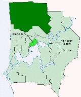
The City of Stirling is a Local Government Area
in the northern suburbs of the Western Australia
n capital city of Perth
, located about 10 kilometres (6 mi) north of Perth's central business district
. The City covers an area of 105.2 square kilometres (40.6 sq mi) and has a population of 193,300 (2008), making it the largest local government area by population in Western Australia.
, Bayswater and Belmont.
With the passage of the Local Government Act 1960, all road districts became Shires effective from 1 July 1961. The Shire of Perth had a population of 84,000 in 1961. It was declared a city and renamed Stirling on 24 January 1971.
Local Government Areas of Western Australia
The Australian state of Western Australia is divided into 141 local government areas...
in the northern suburbs of the Western Australia
Western Australia
Western Australia is a state of Australia, occupying the entire western third of the Australian continent. It is bounded by the Indian Ocean to the north and west, the Great Australian Bight and Indian Ocean to the south, the Northern Territory to the north-east and South Australia to the south-east...
n capital city of Perth
Perth, Western Australia
Perth is the capital and largest city of the Australian state of Western Australia and the fourth most populous city in Australia. The Perth metropolitan area has an estimated population of almost 1,700,000....
, located about 10 kilometres (6 mi) north of Perth's central business district
Central business district
A central business district is the commercial and often geographic heart of a city. In North America this part of a city is commonly referred to as "downtown" or "city center"...
. The City covers an area of 105.2 square kilometres (40.6 sq mi) and has a population of 193,300 (2008), making it the largest local government area by population in Western Australia.
History
Stirling was established in 1871 as the Perth Road District under the District Roads Act 1871. The district at that time included what are now the Cities of Wanneroo, JoondalupCity of Joondalup
The City of Joondalup is a council and Local Government Area with City status in Perth, Western Australia. It covers the metropolitan Perth city of Joondalup in its entirety, as well as the town centres of Hillarys and Warwick....
, Bayswater and Belmont.
With the passage of the Local Government Act 1960, all road districts became Shires effective from 1 July 1961. The Shire of Perth had a population of 84,000 in 1961. It was declared a city and renamed Stirling on 24 January 1971.
Wards
The city has been divided into 7 wards, each of 2 councillors. Each councillor serves a four-year term, and half-elections are held every two years. The mayor is elected from among the councillors.- Balga Ward
- Coastal Ward
- Doubleview Ward
- Hamersley Ward
- Inglewood Ward
- Lawley Ward
- Osborne Ward
Suburbs
|
Herdsman, Western Australia Herdsman is a light industrial suburb of Perth, Western Australia. Its Local Government Area is the City of Stirling.In the earlier days of settlement, cattle were raised near the lake area... Inglewood, Western Australia Inglewood is a suburb of Perth, Western Australia. Its Local Government Area is the City of Stirling.-History:With a name thought to have been derived from the Norwegian barque Inglewood , the suburb of Inglewood began when land was first granted to John Gregory in 1831... Innaloo, Western Australia Innaloo is a suburb of Perth, the capital city of Western Australia, and it is located 9 km from Perth's central business district. Its Local Government Area is the City of Stirling.... Joondanna, Western Australia Joondanna is a suburb of Perth, Western Australia. Its Local Government Area is the City of Stirling.There is a Catholic church, St. Denis, in Joondanna, and a small Catholic primary school of the same name.... Karrinyup, Western Australia Karrinyup is a suburb of Perth, the capital city of Western Australia, and is located 12 km north of Perth's central business district. Its Local Government Area is the City of Stirling... Menora, Western Australia See Menorah about the special lamp holy to Judaism.Menora is a suburb of Perth, Western Australia. Its Local Government Area is the City of Stirling.... Mirrabooka, Western Australia Mirrabooka is a suburb of Perth, Western Australia. Its Local Government Area is the City of Stirling.Mirrabooka is the Aboriginal name for the constellation most commonly known as the Southern Cross.... Mount Lawley, Western Australia Mount Lawley is an inner suburb of Perth, Western Australia. Most of the suburb lies within the Local Government Area of the City of Stirling and small portions are in the City of Vincent and City of Bayswater... Nollamara, Western Australia Nollamara is a suburb of Perth, Western Australia. Its Local Government Area is the City of Stirling.The name "Nollamara" is the Aboriginal word for the plant known as the Black Kangaroo Paw.-Transport:... North Beach, Western Australia North Beach is a northern coastal suburb of Perth, the capital city of Western Australia, and is located from Perth's central business district via Mitchell Freeway and Reid Highway. Its Local Government Area is the City of Stirling.-History:... |
Osborne Park, Western Australia Osborne Park is a suburb of Perth, Western Australia. Its Local Government Area is the City of Stirling.Osborne Park was named after William Osborne, a butcher who owned an abattoir on Wanneroo Road and was elected to the Perth Road Board , in 1875.The suburb was originally full of market gardens,... Scarborough, Western Australia Scarborough is a coastal suburb of Perth, Western Australia, located approximately 14 km northwest of the city centre in the local government area of the City of Stirling... Stirling, Western Australia The City of Stirling is a Local Government Area in the northern suburbs of the Western Australian capital city of Perth, located about north of Perth's central business district... Trigg, Western Australia Trigg is a suburb of Perth, Western Australia. Its Local Government Area is the City of Stirling. Trigg is also the name of a small island off the coast of the suburb of Trigg.... Tuart Hill, Western Australia Tuart Hill is a suburb of Perth, Western Australia.Tuart Hill is named after the Tuart tree that once grew extensively throughout the area, especially around Dog Swamp... Watermans Bay, Western Australia Watermans Bay is a northern coastal suburb of Perth, the capital city of Western Australia. Its Local Government Area is the City of Stirling.-History:... Wembley Downs, Western Australia Wembley Downs is an inner northwestern suburb of Perth, Western Australia. It is about 10 km from the CBD and is located within the City of Stirling, although the Wembley Golf Course, from which the suburb takes its name, is located in the Town of Cambridge.Wembley Downs contains Hale School,... Westminster, Western Australia Westminster is a northern suburb of Perth, Western Australia. Its Local Government Area is the City of Stirling.Westminster was formerly the southern part of Balga but was renamed in 1994 at the request of residents. This was the name of the original estate that existed before residential subdivision... Woodlands, Western Australia Woodlands is a suburb of Perth, Western Australia. Its Local Government Area is the City of Stirling and it is in the federal Division of Curtin.Many of the streets in Woodlands are named after trees, such as oak, elm, birch, sandalwood and willow.... Yokine, Western Australia Yokine is a suburb of Perth, Western Australia. Its Local Government Area is the City of Stirling.-History:The name Yokine was derived from the Aboriginal word meaning native dog. The name was chosen because the area is close to Dog Swamp. Its post code is 6060.Yokine was part of the grant... |
Population
| Year | Population |
|---|---|
| 1911 | 5,066 |
| 1921 | 12,043 |
| 1933 | 19,987 |
| 1947 | 30,989 |
| 1954 | 50,090 |
| 1961 | 84,045 |
| 1966 | 114,410 |
| 1971 | 154,882 |
| 1976 | 162,313 |
| 1981 | 161,858 |
| 1986 | 164,687 |
| 1991 | 172,064 |
| 1996 | 172,819 |
| 2001 | 167,578 |
| 2006 | 176,872 |
- The 1996 figure includes 9,703 residents who were transferred to the City of Bayswater in 1998.