
Burns Beach, Western Australia
Encyclopedia
Burns Beach is a suburb of Perth
, Western Australia
, located 34 kilometres (21 mi) north of Perth's central business district
at the northern fringe of the City of Joondalup
. Burns Beach has managed to maintain much of its original character as a small coastal village even with its loss of isolation, and the beach is popular among hang gliding
enthusiasts.
For many years it was accessible only by track or boat and functioned as a small coastal village, and tourism and fishing were the main occupations. After the Second World War, it was connected by road to Wanneroo Road
.
The sprawl of housing development extending northwards from Perth reached Burns Beach in the early-to-mid 1990s with the growth of Joondalup as a regional centre and the construction of the suburbs of Currambine
and Kinross
.
A new estate, Peet Limited's Burns Beach Estate, is presently being built north of Burns Beach Road. In early 2006 clearing and road widening were undertaken to facilitate the construction. A community centre and school is expected to be built as part of the development.
to the east and Burns Beach Road to the south. Tamala Park
, a bushland buffer to the north, separates Burns Beach and Kinross from the Mindarie
-Clarkson
urban region.
At the ABS
2001 census, Burns Beach had a population of 225 people living in 90 dwellings, with a median age of 39 years (among the oldest in the northern suburbs). A caravan park at the end of Ocean Parade (technically in Iluka) houses another 90 residents. Residential styles in Burns Beach include a mix of holiday dwellings from before and after World War II.
and Clarkson
Community High School catchment areas
.
bus routes from Joondalup, operated by Path Transit
.
preference, fishermen and permanent residents of the caravan park who favour Labor
comprise a fair proportion of those voting at Burns, making it a marginal booth with no clear preference at either federal or state elections
. Nearby Kinross
, an urban residential estate suburb similar to the proposed Burns Beach Estate, favours the Liberal Party although not as strongly as Currambine and Ocean Reef to the south.
Perth, Western Australia
Perth is the capital and largest city of the Australian state of Western Australia and the fourth most populous city in Australia. The Perth metropolitan area has an estimated population of almost 1,700,000....
, Western Australia
Western Australia
Western Australia is a state of Australia, occupying the entire western third of the Australian continent. It is bounded by the Indian Ocean to the north and west, the Great Australian Bight and Indian Ocean to the south, the Northern Territory to the north-east and South Australia to the south-east...
, located 34 kilometres (21 mi) north of Perth's central business district
Central business district
A central business district is the commercial and often geographic heart of a city. In North America this part of a city is commonly referred to as "downtown" or "city center"...
at the northern fringe of the City of Joondalup
City of Joondalup
The City of Joondalup is a council and Local Government Area with City status in Perth, Western Australia. It covers the metropolitan Perth city of Joondalup in its entirety, as well as the town centres of Hillarys and Warwick....
. Burns Beach has managed to maintain much of its original character as a small coastal village even with its loss of isolation, and the beach is popular among hang gliding
Hang gliding
Hang gliding is an air sport in which a pilot flies a light and unmotorized foot-launchable aircraft called a hang glider ....
enthusiasts.
History
The land at Burns Beach was originally owned by the Midland Railway Company. In 1908, following a request from 50 local residents, the Wanneroo Road Board (which eventually became Wanneroo City Council) successfully applied for a 20 hectares (49 acre) reserve for camping and a health resort. By the 1920s, the area was well used by locals who knew the area as "Burns Beach" after a farmer who ran sheep in the area.For many years it was accessible only by track or boat and functioned as a small coastal village, and tourism and fishing were the main occupations. After the Second World War, it was connected by road to Wanneroo Road
Wanneroo Road
Wanneroo Road is an important arterial road in Perth, Australia. It is about 75 kilometres long. It links Perth with the City of Wanneroo, and the Towns of Yanchep and Lancelin...
.
The sprawl of housing development extending northwards from Perth reached Burns Beach in the early-to-mid 1990s with the growth of Joondalup as a regional centre and the construction of the suburbs of Currambine
Currambine, Western Australia
Currambine is a northern suburb of Perth, the capital city of Western Australia, and is located 30 km north of Perth's central business district. Its Local Government Area is the City of Joondalup. It contains the Currambine Market Place shopping centre and cinema complex.-History:Currambine...
and Kinross
Kinross, Western Australia
Kinross is a small suburb in the City of Joondalup located in the northern suburbs of Perth, Australia. Kinross was constructed around 1992-3 in various stages. It is bordered by Neerabup National Park, and is the City of Joondalup's most northerly suburb....
.
Present day
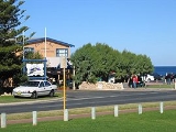
Burns Beach has managed to maintain much of its original character even with its loss of isolation, and the original caravan park is still in operation. Burns Beach marks one end of a coastal nature walk extending to Fremantle. The suburb also contains a cafe and restaurant (Burns Beach Cafe and Restaurant) with outdoor seating, as well as a picnic area with barbecues and toilets.A new estate, Peet Limited's Burns Beach Estate, is presently being built north of Burns Beach Road. In early 2006 clearing and road widening were undertaken to facilitate the construction. A community centre and school is expected to be built as part of the development.
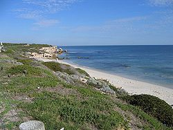
Geography
Burns Beach is bounded by the ocean to the west, Marmion AvenueMarmion Avenue
Marmion Avenue is a major arterial road in Perth, Western Australia, designated State Route 71.It runs through the northern coastal suburbs of Perth from the end of West Coast Highway in Trigg and Karrinyup, to the outer northern suburb of Yanchep...
to the east and Burns Beach Road to the south. Tamala Park
Tamala Park, Western Australia
Tamala Park is an unpopulated locality in Perth, Western Australia. It sits on the border between the City of Wanneroo and the City of Joondalup local authorities, and separates the Clarkson-Butler region from the suburbs of Joondalup.-History:...
, a bushland buffer to the north, separates Burns Beach and Kinross from the Mindarie
Mindarie, Western Australia
Mindarie is an outer coastal suburb of Perth, Western Australia, considered to be northernmost of Perth's affluent beachside suburbs. It is located 36 kilometres north of Perth's central business district via Marmion Avenue and is part of the City of Wanneroo local government area.After being...
-Clarkson
Clarkson, Western Australia
Clarkson is an outer northern suburb of Perth, Western Australia, located 34 kilometres north of Perth's central business district. It is part of the City of Wanneroo local government area. While mostly a residential area, it also functions as a town centre, serving many surrounding areas with a...
urban region.
At the ABS
Australian Bureau of Statistics
The Australian Bureau of Statistics is Australia's national statistical agency. It was created as the Commonwealth Bureau of Census and Statistics on 8 December 1905, when the Census and Statistics Act 1905 was given Royal assent. It had its beginnings in section 51 of the Constitution of Australia...
2001 census, Burns Beach had a population of 225 people living in 90 dwellings, with a median age of 39 years (among the oldest in the northern suburbs). A caravan park at the end of Ocean Parade (technically in Iluka) houses another 90 residents. Residential styles in Burns Beach include a mix of holiday dwellings from before and after World War II.
Education
The nearest primary schools are at Beaumaris (Ocean Reef), Currambine and Kinross. Burns Beach falls within the Ocean Reef Senior High SchoolOcean Reef Senior High School
Ocean Reef Senior High School is a co-educational state high school located in Ocean Reef, north of Perth, Western Australia. Opening in 1983, the school's catchment area covers the northwestern part of the City of Joondalup and, as at Semester 1, 2011, the school has an enrolment of 1,217...
and Clarkson
Clarkson, Western Australia
Clarkson is an outer northern suburb of Perth, Western Australia, located 34 kilometres north of Perth's central business district. It is part of the City of Wanneroo local government area. While mostly a residential area, it also functions as a town centre, serving many surrounding areas with a...
Community High School catchment areas
Catchment area (human geography)
In human geography, a catchment area is the area and population from which a city or individual service attracts visitors or customers. For example, a school catchment area is the geographic area from which students are eligible to attend a local school...
.
Transport
Burns Beach is served by the 470 and 471 TransperthTransperth
Transperth is the brand name of the public transport system in Perth, Western Australia. It is operated by the Public Transport Authority.-History:...
bus routes from Joondalup, operated by Path Transit
Path Transit
Path Transit is a transport company operating 320 buses in Perth, Australia since 1996.It has depots in :* Bayswater* MalagaPath Transit also provides rental of vehicles for private functions.-Vehicles:...
.
Politics
Burns Beach is a reasonably affluent suburb with a large elderly population. While this would normally point to a clear Liberal PartyLiberal Party of Australia
The Liberal Party of Australia is an Australian political party.Founded a year after the 1943 federal election to replace the United Australia Party, the centre-right Liberal Party typically competes with the centre-left Australian Labor Party for political office...
preference, fishermen and permanent residents of the caravan park who favour Labor
Australian Labor Party
The Australian Labor Party is an Australian political party. It has been the governing party of the Commonwealth of Australia since the 2007 federal election. Julia Gillard is the party's federal parliamentary leader and Prime Minister of Australia...
comprise a fair proportion of those voting at Burns, making it a marginal booth with no clear preference at either federal or state elections
Parliament of Western Australia
The Parliament of Western Australia consists of the Legislative Council and the Legislative Assembly . The Parliament sits at Parliament House in Harvest Terrace, Perth....
. Nearby Kinross
Kinross, Western Australia
Kinross is a small suburb in the City of Joondalup located in the northern suburbs of Perth, Australia. Kinross was constructed around 1992-3 in various stages. It is bordered by Neerabup National Park, and is the City of Joondalup's most northerly suburb....
, an urban residential estate suburb similar to the proposed Burns Beach Estate, favours the Liberal Party although not as strongly as Currambine and Ocean Reef to the south.