

Microwave landing system
Encyclopedia

Instrument Landing System
An instrument landing system is a ground-based instrument approach system that provides precision guidance to an aircraft approaching and landing on a runway, using a combination of radio signals and, in many cases, high-intensity lighting arrays to enable a safe landing during instrument...
s (ILS). MLS has a number of operational advantages, including a wide selection of channels to avoid interference with other nearby airports, excellent performance in all weather, and a small "footprint" at the airports.
Although some MLS systems became operational in the 1990s, the widespread deployment initially envisioned by its designers never became a reality. GPS
Global Positioning System
The Global Positioning System is a space-based global navigation satellite system that provides location and time information in all weather, anywhere on or near the Earth, where there is an unobstructed line of sight to four or more GPS satellites...
-based systems, notably WAAS
Wide Area Augmentation System
The Wide Area Augmentation System is an air navigation aid developed by the Federal Aviation Administration to augment the Global Positioning System , with the goal of improving its accuracy, integrity, and availability...
, allowed the expectation of the same level of positioning detail with no equipment needed at the airport
Airport
An airport is a location where aircraft such as fixed-wing aircraft, helicopters, and blimps take off and land. Aircraft may be stored or maintained at an airport...
. GPS/WAAS dramatically lowers the cost of implementing precision landing approaches, and since its introduction most existing MLS systems in North America have been turned off. GPS/WAAS-based LPV
Localizer Performance with Vertical guidance
Localizer performance with vertical guidance are the highest precision GPS aviation instrument approach procedures currently available without specialized aircrew training requirements, such as required navigation performance...
'Localizer Performance with Vertical guidance' approaches provide vertical guidance comparable to ILS Category I and FAA-published LPV approaches currently outnumber ILS approaches at US airports.
MLS continues to be of some interest in Europe, where concerns over the availability of GPS continue to be an issue. A widespread installation in the United Kingdom is currently underway, which included installing MLS receivers on most British Airways
British Airways
British Airways is the flag carrier airline of the United Kingdom, based in Waterside, near its main hub at London Heathrow Airport. British Airways is the largest airline in the UK based on fleet size, international flights and international destinations...
aircraft, but the continued deployment of the system is in doubt. NASA
NASA
The National Aeronautics and Space Administration is the agency of the United States government that is responsible for the nation's civilian space program and for aeronautics and aerospace research...
operated a similar system called the Microwave Scanning Beam Landing System
Microwave Scanning Beam Landing System
The Microwave Scanning Beam Landing System is a Ku band approach and landing navigation aid formerly used by NASA's space shuttle. It provides precise elevation, directional and distance data which was used to guide the orbiter for the last two minutes of flight until touchdown...
to land the Space Shuttle
Space Shuttle program
NASA's Space Shuttle program, officially called Space Transportation System , was the United States government's manned launch vehicle program from 1981 to 2011...
.
Radio navigation
Radio navigation
Radio navigation or radionavigation is the application of radio frequencies to determine a position on the Earth. Like radiolocation, it is a type of radiodetermination.The basic principles are measurements from/to electric beacons, especially...
aids in general (including MLS) require calibration to ensure accuracy, which is done periodically through flight inspection
Flight inspection
The evaluation process, using properly equipped aircraft, regarding continuity, integrity and accuracy of significant parameters from radio navigation aids and procedures, aiming their calibration with international standards....
.
Principle
MLS employs 5GHz transmitters at the landing place which use passive electronically scanned arrayPassive electronically scanned array
A passive electronically scanned array , contrary to its active counterpart AESA, is a phased array which has a central radiofrequency source , sending energy into phase shift modules, which then send energy into the various emitting elements in the front of the antenna...
s to send scanning beams towards approaching aircraft. An aircraft that enters the scanned volume uses a special receiver that calculates its position by measuring the arrival times of the beams.
History
The US version of MLS was a joint development between the FAAFederal Aviation Administration
The Federal Aviation Administration is the national aviation authority of the United States. An agency of the United States Department of Transportation, it has authority to regulate and oversee all aspects of civil aviation in the U.S...
, NASA
NASA
The National Aeronautics and Space Administration is the agency of the United States government that is responsible for the nation's civilian space program and for aeronautics and aerospace research...
, and the U.S. Department of Defense
United States Department of Defense
The United States Department of Defense is the U.S...
, was designed to provide precision navigation guidance for exact alignment and descent of aircraft on approach to a runway. The design was e.g. advised by Herbert Raabe. It provides azimuth, elevation, and distance, as well as "back azimuth", for navigating from an aborted landing or missed approach. MLS channels were also used for short-range communications with airport controllers, allowing long-distance frequencies to be handed over to other aircraft.
In Australia
Australia
Australia , officially the Commonwealth of Australia, is a country in the Southern Hemisphere comprising the mainland of the Australian continent, the island of Tasmania, and numerous smaller islands in the Indian and Pacific Oceans. It is the world's sixth-largest country by total area...
, design work commenced on its version of an MLS in 1972. Most of this work was jointly done by the then Federal Department of Civil Aviation (DCA), and the Radio Physics Division of the Commonwealth Scientific and Industrial Research Organisation (CSIRO). The project was called Interscan, one of several microwave landing systems under consideration internationally. Interscan was chosen by the FAA in 1975 and by ICAO in 1978 as the format to be adopted. An engineered version of the system, called MITAN, was developed by industry (Amalgamated Wireless Australasia Limited
Amalgamated Wireless Australasia Limited
Amalgamated Wireless Ltd . Throughout most of the 20th century AWA was Australia's largest and most prominent electronics organisation, undertaking development, manufacture and distribution of radio, telecommunications, television and audio equipment as well as broadcasting services.After the...
and Hawker de Havilland
De Havilland
The de Havilland Aircraft Company was a British aviation manufacturer founded in 1920 when Airco, of which Geoffrey de Havilland had been chief designer, was sold to BSA by the owner George Holt Thomas. De Havilland then set up a company under his name in September of that year at Stag Lane...
) under a contract with DCA's successor, the Department of Transport, and successfully demonstrated at Melbourne Airport
Melbourne Airport
Melbourne Airport , also known as Tullamarine Airport, is the primary airport serving the city of Melbourne and the second busiest in Australia. It was opened in 1970 to replace the nearby Essendon Airport. Melbourne Airport is the sole international airport of the four airports serving the...
(Tullamarine) in the late 1970s. The white antenna dishes could still be seen at Tullamarine up till 2003 before it was dismantled. This initial research was followed by the formation of Interscan International limited in Sydney, Australia in 1979 who manufactured MLS systems that were subsequently deployed in the US, EU, Taiwan, China and Australia. The CAA in UK developed a version of the MLS which is installed at Heathrow and other airports due to the greater incidence of instrument approaches and Cat II/III weather there. GPS has not yet solved the critical problems needed to match the MLS international standard.
Instrument Landing System
An instrument landing system is a ground-based instrument approach system that provides precision guidance to an aircraft approaching and landing on a runway, using a combination of radio signals and, in many cases, high-intensity lighting arrays to enable a safe landing during instrument...
system, MLS had significant advantages. The antennas were much smaller, due to using a higher frequency signal. They also did not have to be placed at a specific point at the airport, and could "offset" their signals electronically. This made placement at the airports much simpler compared to the large ILS
Instrument Landing System
An instrument landing system is a ground-based instrument approach system that provides precision guidance to an aircraft approaching and landing on a runway, using a combination of radio signals and, in many cases, high-intensity lighting arrays to enable a safe landing during instrument...
systems, which had to be placed at the ends of the runways and along the approach path.
Another advantage was that the MLS signals covered a very wide fan-shaped area off the end of the runway, allowing controllers to vector aircraft in from a variety of directions or guide aircraft along a segmented approach. In comparison, ILS
Instrument Landing System
An instrument landing system is a ground-based instrument approach system that provides precision guidance to an aircraft approaching and landing on a runway, using a combination of radio signals and, in many cases, high-intensity lighting arrays to enable a safe landing during instrument...
required the aircraft to fly down a single straight line, requiring controllers to distribute planes along that line. MLS allowed aircraft to approach from whatever direction they were already flying in, as opposed to flying to a parking orbit before "capturing" the ILS
Instrument Landing System
An instrument landing system is a ground-based instrument approach system that provides precision guidance to an aircraft approaching and landing on a runway, using a combination of radio signals and, in many cases, high-intensity lighting arrays to enable a safe landing during instrument...
signal. This was particularly interesting to larger airports, as it potentially allowed the aircraft to be separated horizontally until much closer to the airport. Similarly in elevation, the fan shape coverage allows for variation in approach angle making MLS particularly suited to aircraft with steep approach angles such as helicopters, fighters and the space shuttle.
Instrument Landing System
An instrument landing system is a ground-based instrument approach system that provides precision guidance to an aircraft approaching and landing on a runway, using a combination of radio signals and, in many cases, high-intensity lighting arrays to enable a safe landing during instrument...
, which required a variety of frequencies to broadcast the various signals, MLS used a single frequency, broadcasting the azimuth and altitude information one after the other. This reduced frequency contention, as did the fact that the frequencies used were well away from FM
FM broadcasting
FM broadcasting is a broadcasting technology pioneered by Edwin Howard Armstrong which uses frequency modulation to provide high-fidelity sound over broadcast radio. The term "FM band" describes the "frequency band in which FM is used for broadcasting"...
broadcasts, another problem with ILS
Instrument Landing System
An instrument landing system is a ground-based instrument approach system that provides precision guidance to an aircraft approaching and landing on a runway, using a combination of radio signals and, in many cases, high-intensity lighting arrays to enable a safe landing during instrument...
. Additionally, MLS offered two hundred channels, making the possibility of contention between airports in the same area extremely remote.
Finally, the accuracy was greatly improved over ILS
Instrument Landing System
An instrument landing system is a ground-based instrument approach system that provides precision guidance to an aircraft approaching and landing on a runway, using a combination of radio signals and, in many cases, high-intensity lighting arrays to enable a safe landing during instrument...
. For instance, standard DME
Distance Measuring Equipment
Distance measuring equipment is a transponder-based radio navigation technology that measures distance by timing the propagation delay of VHF or UHF radio signals....
equipment used with ILS
Instrument Landing System
An instrument landing system is a ground-based instrument approach system that provides precision guidance to an aircraft approaching and landing on a runway, using a combination of radio signals and, in many cases, high-intensity lighting arrays to enable a safe landing during instrument...
offered range accuracy of only +/- 1200 feet. MLS improved this to +/- 100 ft in what they referred to as DME/P (for precision), and offered similar improvements in azimuth and altitude. This allowed MLS to guide the extremely accurate CAT III approaches, whereas this normally required an expensive ground-based high precision radar.
Similar to other precision landing systems, lateral and vertical guidance may be displayed on conventional course deviation indicators or incorporated into multipurpose cockpit displays. Range information can also be displayed by conventional DME indicators and also incorporated into multipurpose displays.
It was originally intended that ILS
Instrument Landing System
An instrument landing system is a ground-based instrument approach system that provides precision guidance to an aircraft approaching and landing on a runway, using a combination of radio signals and, in many cases, high-intensity lighting arrays to enable a safe landing during instrument...
would remain in operation until 2010 before being replaced by MLS. The system was only being installed experimentally in the 1980s when the FAA began to favor GPS. Even in the worst cases, GPS offered at least 300 ft accuracy, not as good as MLS, but much better than ILS
Instrument Landing System
An instrument landing system is a ground-based instrument approach system that provides precision guidance to an aircraft approaching and landing on a runway, using a combination of radio signals and, in many cases, high-intensity lighting arrays to enable a safe landing during instrument...
. Additionally, GPS worked "everywhere", not just off the end of the runways. This meant that a single navigation instrument could replace both short and long-range navigation systems, offer better accuracy than either, and required no ground-based equipment.
The major issues with GPS, namely 2 feet vertical guidance accuracy near the runway threshold and the integrity of the system has not been able to match historical ICAO standards and practices. Additional GPS accuracy could be provided by sending out "correcting signals" from ground-based stations, which would improve the accuracy to about 10 m in the worst case, far outperforming MLS. Initially it was planned to send these signals out over short-range FM transmissions on commercial radio frequencies, but this proved to be too difficult to arrange. Today a similar signal is instead sent across all of North America via commercial satellites, in a system known as WAAS
Wide Area Augmentation System
The Wide Area Augmentation System is an air navigation aid developed by the Federal Aviation Administration to augment the Global Positioning System , with the goal of improving its accuracy, integrity, and availability...
. However WAAS is not capable of providing CAT II or CAT III standard signals (those required for autolanding) and so a Local Area Augmentation System, or LAAS, must be used.
Operational Functions
The system may be divided into five functions: Approach azimuth, Back azimuth, Approach elevation, Range and Data communications.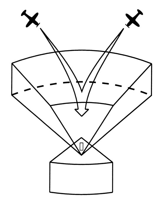
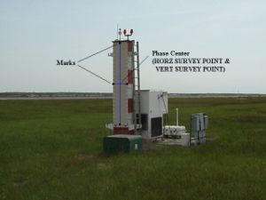
Approach azimuth guidance
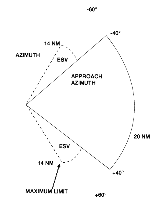
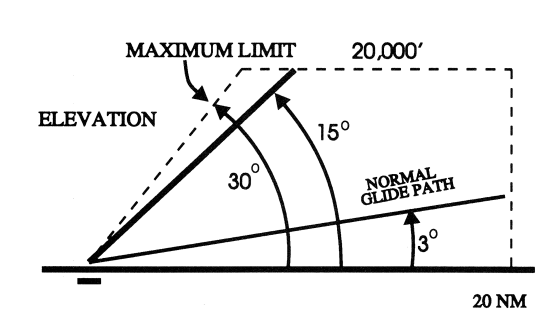
The azimuth coverage extends: Laterally, at least 40 degrees on either side of the runway centerline in a standard configuration. In elevation, up to an angle of 15 degrees and to at least 20,000 feet (6 km), and in range, to at least 20 nautical miles (37 km) (See FIG 1-1-8.)
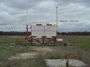
Elevation guidance
The elevation station transmits signals on the same frequency as the azimuth station. A single frequency is time-shared between angle and data functions and is normally located about 400 feet from the side of the runway between runway threshold and the touchdown zone.Elevation coverage is provided in the same airspace as the azimuth guidance signals: In elevation, to at least +15 degrees; Laterally, to fill the Azimuth lateral coverage and in range, to at least 20 nautical miles (37 km) (See FIG 1-1-9.)
Range guidance
The MLS Precision Distance Measuring EquipmentDistance Measuring Equipment
Distance measuring equipment is a transponder-based radio navigation technology that measures distance by timing the propagation delay of VHF or UHF radio signals....
(DME/P) functions the same as the navigation DME, but there are some technical differences. The beacon transponder operates in the frequency band 962 to 1105 MHz and responds to an aircraft interrogator. The MLS DME/P accuracy is improved to be consistent with the accuracy provided by the MLS azimuth and elevation stations.
A DME/P channel is paired with the azimuth and elevation channel. A complete listing of the 200 paired channels of the DME/P with the angle functions is contained in FAA Standard 022 (MLS Interoperability and Performance Requirements).
The DME/N or DME/P is an integral part of the MLS and is installed at all MLS facilities unless a waiver is obtained. This occurs infrequently and only at outlying, low density airports where marker beacon
Marker beacon
A marker beacon is a particular type of VHF radio beacon used in aviation, usually in conjunction with an instrument landing system , to give pilots a means to determine position along an established route to a destination such as a runway...
s or compass locator
Non-directional beacon
A non-directional beacon is a radio transmitter at a known location, used as an aviation or marine navigational aid. As the name implies, the signal transmitted does not include inherent directional information, in contrast to other navigational aids such as low frequency radio range, VHF...
s are already in place.
Data communications
The data transmission can include both the basic and auxiliary data words. All MLS facilities transmit basic data. Where needed, auxiliary data can be transmitted. MLS data are transmitted throughout the azimuth (and back azimuth when provided) coverage sectors. Representative data include: Station identification, Exact locations of azimuth, elevation and DME/P stations (for MLS receiver processing functions), Ground equipment performance level; and DME/P channel and status.MLS identification is a four-letter designation starting with the letter M. It is transmitted in International Morse Code
Morse code
Morse code is a method of transmitting textual information as a series of on-off tones, lights, or clicks that can be directly understood by a skilled listener or observer without special equipment...
at least six times per minute by the approach azimuth (and back azimuth) ground equipment.
Auxiliary data content: Representative data include: 3-D locations of MLS equipment, Waypoint coordinates, Runway conditions and Weather (e.g., RVR, ceiling, altimeter setting, wind, wake vortex, wind shear).
Future
There are different requirements when it comes to landing in Europe and the USA. In the USA, if pilots are unable to see the runway due to low visibility conditions, the aircraft can generally divert to another airport. In Europe, due to its smaller land area, low visibility can affect all airports in the vicinity, forcing planes to land in low visibility conditions.In the United States, the FAA suspended the MLS program in 1994 in favor of the GPS (Wide Area Augmentation System
Wide Area Augmentation System
The Wide Area Augmentation System is an air navigation aid developed by the Federal Aviation Administration to augment the Global Positioning System , with the goal of improving its accuracy, integrity, and availability...
WAAS). The FAA's inventory of instrument flight procedures no longer includes any MLS locations; the last two were eliminated in 2008.
Many countries in Europe (particularly those known for low visibility conditions) have embraced the MLS system as a replacement to ILS
Instrument Landing System
An instrument landing system is a ground-based instrument approach system that provides precision guidance to an aircraft approaching and landing on a runway, using a combination of radio signals and, in many cases, high-intensity lighting arrays to enable a safe landing during instrument...
.
See also
- Instrument Landing System (ILS)Instrument Landing SystemAn instrument landing system is a ground-based instrument approach system that provides precision guidance to an aircraft approaching and landing on a runway, using a combination of radio signals and, in many cases, high-intensity lighting arrays to enable a safe landing during instrument...
- Local Area Augmentation System (LAAS)Local Area Augmentation SystemThe Local Area Augmentation System is an all-weather aircraft landing system based on real-time differential correction of the GPS signal. Local reference receivers located around the airport send data to a central location at the airport. This data is used to formulate a correction message, which...
- Transponder Landing System (TLS)Transponder Landing SystemA transponder landing system is an all-weather, precision landing system that uses existing airborne transponder and instrument landing system equipment to create a precision approach at a location where an ILS would normally not be available....
- Wide Area Augmentation System (WAAS)Wide Area Augmentation SystemThe Wide Area Augmentation System is an air navigation aid developed by the Federal Aviation Administration to augment the Global Positioning System , with the goal of improving its accuracy, integrity, and availability...
- Microwave Scanning Beam Landing SystemMicrowave Scanning Beam Landing SystemThe Microwave Scanning Beam Landing System is a Ku band approach and landing navigation aid formerly used by NASA's space shuttle. It provides precise elevation, directional and distance data which was used to guide the orbiter for the last two minutes of flight until touchdown...