
.gif)
Metropolitan Area Express (Portland, Oregon)
Encyclopedia
Metropolitan Area Express (MAX) is a light rail
system in the Portland metropolitan area
in the U.S. state
of Oregon
. It is operated by TriMet
and currently has four lines: Blue
, Green
, Red
and Yellow
, with an Orange
line currently under construction.
The number of weekday boardings on the MAX system averages between about 123,000 and 130,000 per day, depending on the time of year, but was 126,800 per day (weekdays) for the 12-month period from July 2010 through June 2011 (TriMet's Fiscal Year 2011) and has been as high as 134,300 per day in a given month. Total MAX ridership in FY2011 was 41.2 million. Since its inception about $3 billion has been invested in light rail in Portland (as of 2004).
Construction of the 15 miles (24.1 km) route started in 1982, and the system opened on September 5, 1986. Of the project's total cost of $214 million, 83 percent was funded by the federal Urban Mass Transportation Administration
(now known as the Federal Transit Administration
). Less than two months before the opening, TriMet adopted the name Metropolitan Area Express, or MAX, for the new system following an employee contest.
As planning of a second light rail line, to the west side, gained momentum in the late 1980s, the MAX line came to be referred to as the Eastside MAX line, so as to distinguish it from the Westside MAX project. The 18 miles (29 km) Westside line, to Beaverton and Hillsboro, began construction in 1993 and opened in 1998. Except for a few rush-hour trips, all trips on the now-two light rail lines were connected in downtown
. The resulting 33 miles (53 km) east-west line has always been operated as a single, through route, and it became known as the Blue Line
in 2001, after TriMet adopted color designations for its separate light rail routes.
, MAX trains run on surface streets. Except for on the Portland Transit Mall
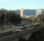
, trains run in reserved lanes closed to other motorized vehicles. On the Transit Mall, trains operate on the same lanes as TriMet buses (although MAX trains have traffic priority). Elsewhere, MAX runs within its own exclusive right-of-way, in street medians, alongside freeways, and on former freight railroad lines.
Where the tracks run along a street, intersections are generally controlled by traffic signals which give trains preemption
. Where the tracks occupy a completely separate right-of-way, level crossing
s are protected by automatic crossing gate
s giving trains the right-of-way. A three-mile (4.8 km) section consists of two tunnels
below Washington Park. While this section has only one station
, it is 260 feet (79 m) below ground level, making it the deepest transit station in North America and one of the deepest in the world.
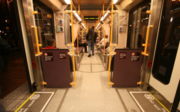
Because of Portland's relatively small 200 feet (61 m) downtown blocks
, trains operate with only one or two cars. The MAX cars are about 90 feet (27.4 m) long, so a stopped train consisting of more than two cars would block intersections. All service is typically operated with two-car trains, except for certain trips during late-night hours. During the first few years of Red Line and Yellow Line service, those lines normally used single cars on a portion of their service, but as ridership has grown and additional light rail cars have been acquired, those lines now normally use all two-car trains. The 2009-introduced MAX Mall Shuttle, which provided supplementary service along the Portland Transit Mall on weekday afternoons only, normally always used a single car; it was discontinued in June 2011.
on August 30, 2009, introducing light rail service along the Mall. The Green Line began serving the Mall on September 12, 2009.
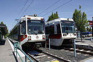
The system currently has a total of 85 stations. 51 stations are served by the Blue Line, 28 stations by the Green Line, 29 by the Red Line, and 22 by the Yellow Line, with 38 stations served by two or more lines and 8 by three. The system's central stations are at Pioneer Courthouse Square
, on the Portland Transit Mall. These stops, on three sides of the square, are near the center of the Free Rail Zone (formerly known as Fareless Square), a section in and around downtown Portland in which all MAX and Portland Streetcar rides are zero-fare (free). All trains also connect at the Rose Quarter
.
The trains operate on direct current
and utilize two voltages, 750V DC nominal on sections west of NE 9th Avenue & Holladay Street and 825V DC nominal on the remainder. The two systems are electrically isolated.
Trains run every 15 minutes from early in the morning until late at night, even on weekends. The Blue Line runs every 10 minutes during rush hour. Headways between trains are shorter in the central section of the system, where lines overlap. Actual schedules vary by location and time of day. At many stations, a live readerboard shows the destination and time-to-arrival of the next several trains, using data gathered by a vehicle tracking system
.
In addition to regular MAX service, the Portland Vintage Trolley
runs along the Portland Mall MAX tracks on some Sundays, serving the same stops. From 1991 until 2009, the vintage trolley service followed a section of the original MAX line, between the Galleria/Library stations and Lloyd Center
, but in September 2009 the service moved to the newly opened MAX alignment along the transit mall, running from Union Station
to Portland State University
.
 There are currently four models of MAX cars, designated by TriMet as "Type 1", "Type 2" and so on.
The Type 1 cars were manufactured by Bombardier Corporation
and featured a raised floor with steps at the doors. The first car was completed at the factory in late 1983 and arrived in Portland in 1984.
With the partial opening of Westside MAX in 1997, new cars made by Siemens
and called Type 2 by TriMet were introduced. These cars have a low-floor
design, a first for light rail cars in North America, digital readerboards and a slightly more open floor plan. The floor is nearly level with the platforms
, and small ramps called "bridge plate
s" extend (on request) from two of the four doors, enabling passengers in wheelchairs to roll on and off of the car easily. These permitted the elimination of wheelchair lift
s that had been located at every station and were time-consuming to use. Type 1 cars are now always paired with a Type 2 or 3 car so that each train is wheelchair-accessible.
 The first low-floor light rail car was delivered in 1996 and the type was first used in service on August 31, 1997. The new cars also came equipped with air-conditioning, a feature originally lacking from the Type 1 cars, but TriMet later retrofitted air-conditioning to all of the older MAX cars, in 1997-98. The initial order of 39 Type 2 cars was expanded, in stages, eventually to a total of 52 cars.
Some of the later models of light rail cars had automatic passenger counters retrofitted; in these models, they are on the floor of the doorways.
The Type 3 cars are essentially identical to the Type 2 cars in design, but have TriMet's new paint scheme. They began to enter service in fall 2003, but were not in use in large numbers until the opening of the Interstate Avenue MAX line in 2004, which was the reason for their acquisition. They include automatic passenger counters which are located above the doorways, using photoelectric sensors.
In 2001-02, TriMet modified the interior of the Type 2 cars to add space for bicycles. Eight seats per car were removed and replaced—in four places per car—with hooks from which a bicycle can be hung. The Type 3 cars carried this newer layout as built.
Twenty-two new Siemens S70
vehicles, designated Type 4 cars, have been purchased in conjunction with the I-205 and Portland Mall MAX projects. They feature a more streamlined design than previous models, have more seating and are lighter in weight and therefore more energy-efficient. At about 95 feet (28.96 m) long, they are about three feet longer than Type 2 and Type 3 cars, which were 92 feet (28.04 m). The Type 4 MAX cars began to enter service in August 2009. All four different types of cars are used on all four MAX lines.
The Type 1, 2 and 3 cars have destination sign
s of the roll-type, whereas the signs in the Type 4 cars are LED-type
. In the rollsigns, the designated route color (blue, green, red or yellow) is shown as a colored background under white (or black) text in the display, while in the LED signs the route color is indicated by a colored square at the left end of the display, and all text is orange lettering against a black background.
Notes on capacities:
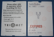
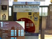 MAX uses a proof-of-payment
system; riders must carry a receipt at all times. Fares are purchased before boarding, and receipt is retained as proof of paid fare. Passengers must board the train before the receipt's expiration, and are allowed to ride past the time on the receipt, provided the train was boarded before the expiration time. Receipts are good for 2 hours after purchase, and can be used an unlimited number of times, for travel in any direction, as well as for buses, Portland Streetcar
, and C-Tran.
MAX fares (as of October 22, 2011) are:
Transfer receipts from buses and tickets purchased on the Portland Streetcar are also valid fare on MAX, provided they cover the zones through which the MAX trip is being made and have not expired before boarding. As noted above, MAX tickets are also valid on bus routes, under the same conditions.
Riding is free in the Free Rail Zone which includes all of downtown and part of the Lloyd Center area.
Light rail
Light rail or light rail transit is a form of urban rail public transportation that generally has a lower capacity and lower speed than heavy rail and metro systems, but higher capacity and higher speed than traditional street-running tram systems...
system in the Portland metropolitan area
Portland metropolitan area
The Portland-Vancouver-Hillsboro, OR-WA Metropolitan Statistical Area , also known as the Portland metropolitan area or Greater Portland, is an urban area in the U.S. states of Oregon and Washington centered around the city of Portland, Oregon. The U.S...
in the U.S. state
U.S. state
A U.S. state is any one of the 50 federated states of the United States of America that share sovereignty with the federal government. Because of this shared sovereignty, an American is a citizen both of the federal entity and of his or her state of domicile. Four states use the official title of...
of Oregon
Oregon
Oregon is a state in the Pacific Northwest region of the United States. It is located on the Pacific coast, with Washington to the north, California to the south, Nevada on the southeast and Idaho to the east. The Columbia and Snake rivers delineate much of Oregon's northern and eastern...
. It is operated by TriMet
TriMet
TriMet, more formally known as the Tri-County Metropolitan Transportation District of Oregon, is a public agency that operates mass transit in a region that spans most of the Portland metropolitan area in the U.S. state of Oregon...
and currently has four lines: Blue
MAX Blue Line
The MAX Blue Line is a 33 mile light rail line in the MAX Light Rail system in the Portland metropolitan area in the U.S. state of Oregon. Operated by TriMet, the line runs between Hillsboro and Gresham, via downtown Portland...
, Green
MAX Green Line
The MAX Green Line is a light rail route in the MAX Light Rail system in Portland, Oregon, United States, extending to Clackamas, Oregon. Construction began in early 2007, and the line opened on September 12, 2009. The average daily ridership in June 2010 was 19,500 increasing to 23,200 by April...
, Red
MAX Red Line
The MAX Red Line is a route in the Metropolitan Area Express light rail system in the Portland, Oregon metropolitan area. It is 25.5 miles long...
and Yellow
MAX Yellow Line
The MAX Yellow Line is a 5.8-mile route in the Metropolitan Area Express light rail system in Portland, Oregon. The route, which opened May 1, 2004, runs between Portland State University , in downtown Portland, and the Portland Expo Center...
, with an Orange
MAX Orange Line
The MAX Orange Line is a planned light rail line for the Metropolitan Area Express light rail system in Portland, Oregon, USA. It is currently under construction. The line is the second part of a two-phase transportation plan known as the South Corridor Project, bringing light rail service to...
line currently under construction.
The number of weekday boardings on the MAX system averages between about 123,000 and 130,000 per day, depending on the time of year, but was 126,800 per day (weekdays) for the 12-month period from July 2010 through June 2011 (TriMet's Fiscal Year 2011) and has been as high as 134,300 per day in a given month. Total MAX ridership in FY2011 was 41.2 million. Since its inception about $3 billion has been invested in light rail in Portland (as of 2004).
Early system history
In the mid-1970s, TriMet (or Tri-Met, as it was known until 2002) began a study for light rail using funds intended for the cancelled Mount Hood Freeway. The light rail project was known as the Banfield Light Rail Project, named for the freeway (I-84) that part of the alignment followed. The TriMet board approved the project in September 1978. Gresham officials and businesses initially rejected the plans until a slight routing change was agreed to.Construction of the 15 miles (24.1 km) route started in 1982, and the system opened on September 5, 1986. Of the project's total cost of $214 million, 83 percent was funded by the federal Urban Mass Transportation Administration
Federal Transit Administration
The Federal Transit Administration is an agency within the United States Department of Transportation that provides financial and technical assistance to local public transit systems. The FTA is one of ten modal administrations within the DOT...
(now known as the Federal Transit Administration
Federal Transit Administration
The Federal Transit Administration is an agency within the United States Department of Transportation that provides financial and technical assistance to local public transit systems. The FTA is one of ten modal administrations within the DOT...
). Less than two months before the opening, TriMet adopted the name Metropolitan Area Express, or MAX, for the new system following an employee contest.
As planning of a second light rail line, to the west side, gained momentum in the late 1980s, the MAX line came to be referred to as the Eastside MAX line, so as to distinguish it from the Westside MAX project. The 18 miles (29 km) Westside line, to Beaverton and Hillsboro, began construction in 1993 and opened in 1998. Except for a few rush-hour trips, all trips on the now-two light rail lines were connected in downtown
Downtown Portland
Downtown Portland, the city center of Portland, Oregon, United States, is located on the west bank of the Willamette River. It is in the northeastern corner of the southwest section of the city and is where most of the city's high-rise buildings are found....
. The resulting 33 miles (53 km) east-west line has always been operated as a single, through route, and it became known as the Blue Line
MAX Blue Line
The MAX Blue Line is a 33 mile light rail line in the MAX Light Rail system in the Portland metropolitan area in the U.S. state of Oregon. Operated by TriMet, the line runs between Hillsboro and Gresham, via downtown Portland...
in 2001, after TriMet adopted color designations for its separate light rail routes.
General description
In parts of the MAX system, particularly in central Portland and HillsboroHillsboro, Oregon
Hillsboro is the fifth-largest city in the U.S. state of Oregon and is the county seat of Washington County. Lying in the Tualatin Valley on the west side of the Portland metropolitan area, the city is home to many high-technology companies, such as Intel, that compose what has become known as the...
, MAX trains run on surface streets. Except for on the Portland Transit Mall
Portland Transit Mall
The Portland Transit Mall is a set of public transit corridors through the center of downtown Portland, Oregon, United States. More specifically, it is a pair of one-way streets—one for northbound traffic, the other for southbound—along which two of the three lanes are restricted to...
, trains run in reserved lanes closed to other motorized vehicles. On the Transit Mall, trains operate on the same lanes as TriMet buses (although MAX trains have traffic priority). Elsewhere, MAX runs within its own exclusive right-of-way, in street medians, alongside freeways, and on former freight railroad lines.
Where the tracks run along a street, intersections are generally controlled by traffic signals which give trains preemption
Traffic signal preemption
Traffic signal preemption is a type of system that allows the normal operation of traffic lights to be preempted, often to assist emergency vehicles...
. Where the tracks occupy a completely separate right-of-way, level crossing
Level crossing
A level crossing occurs where a railway line is intersected by a road or path onone level, without recourse to a bridge or tunnel. It is a type of at-grade intersection. The term also applies when a light rail line with separate right-of-way or reserved track crosses a road in the same fashion...
s are protected by automatic crossing gate
Boom barrier
A boom barrier is a bar, or pole pivoted in such a way as to allow the boom to block vehicular access through a controlled point. Typically the tip of a boom gate rises in a vertical arc to a near vertical position. Boom gates are often counterweighted, so the pole is easily tipped...
s giving trains the right-of-way. A three-mile (4.8 km) section consists of two tunnels
Robertson Tunnel
The Robertson Tunnel is a tunnel through the west hills of Portland, Oregon, U.S. for the TriMet public transit MAX Light Rail system. The tunnel is 3.1 miles long and consists of twin 21 foot diameter tunnels. There is one station within the tunnel at Washington Park, the third deepest such...
below Washington Park. While this section has only one station
Washington Park (MAX station)
Washington Park is a station in the MAX Light Rail system of TriMet, served by the Blue and Red lines. It is located in Portland, Oregon and is a part of the Robertson Tunnel under Portland's West Hills. It is the fourth station westbound on the Westside MAX alignment...
, it is 260 feet (79 m) below ground level, making it the deepest transit station in North America and one of the deepest in the world.
Because of Portland's relatively small 200 feet (61 m) downtown blocks
City block
A city block, urban block or simply block is a central element of urban planning and urban design. A city block is the smallest area that is surrounded by streets. City blocks are the space for buildings within the street pattern of a city, they form the basic unit of a city's urban fabric...
, trains operate with only one or two cars. The MAX cars are about 90 feet (27.4 m) long, so a stopped train consisting of more than two cars would block intersections. All service is typically operated with two-car trains, except for certain trips during late-night hours. During the first few years of Red Line and Yellow Line service, those lines normally used single cars on a portion of their service, but as ridership has grown and additional light rail cars have been acquired, those lines now normally use all two-car trains. The 2009-introduced MAX Mall Shuttle, which provided supplementary service along the Portland Transit Mall on weekday afternoons only, normally always used a single car; it was discontinued in June 2011.
Lines and stations
TriMet runs four MAX lines, each designated by a color. The MAX system was built in a series of five separate projects, and each line runs over one or more of the previously opened segments. The use of colors to distinguish the separately operated routes was first adopted in 2000 and brought into use in 2001. The 2004-opened Yellow Line originally followed the same routing in downtown Portland as the Red and Blue lines, along First Avenue, Morrison Street and Yamhill Street, but it was shifted to a new alignment along the Portland Transit MallPortland Transit Mall
The Portland Transit Mall is a set of public transit corridors through the center of downtown Portland, Oregon, United States. More specifically, it is a pair of one-way streets—one for northbound traffic, the other for southbound—along which two of the three lanes are restricted to...
on August 30, 2009, introducing light rail service along the Mall. The Green Line began serving the Mall on September 12, 2009.
The system currently has a total of 85 stations. 51 stations are served by the Blue Line, 28 stations by the Green Line, 29 by the Red Line, and 22 by the Yellow Line, with 38 stations served by two or more lines and 8 by three. The system's central stations are at Pioneer Courthouse Square
Pioneer Courthouse Square
Pioneer Courthouse Square, affectionately known as Portland's living room, is a public space occupying a full 40,000 ft² city block in the center of downtown Portland, Oregon, United States...
, on the Portland Transit Mall. These stops, on three sides of the square, are near the center of the Free Rail Zone (formerly known as Fareless Square), a section in and around downtown Portland in which all MAX and Portland Streetcar rides are zero-fare (free). All trains also connect at the Rose Quarter
Rose Quarter
The Rose Quarter is a 30 acre sports and entertainment district located in Portland's Lloyd District on the east bank of the Willamette River, just east of downtown. The Rose Quarter is bounded on the west by NE Interstate Avenue, on the north by NE Broadway and NE Weidler Streets, on the...
.
The trains operate on direct current
Direct current
Direct current is the unidirectional flow of electric charge. Direct current is produced by such sources as batteries, thermocouples, solar cells, and commutator-type electric machines of the dynamo type. Direct current may flow in a conductor such as a wire, but can also flow through...
and utilize two voltages, 750V DC nominal on sections west of NE 9th Avenue & Holladay Street and 825V DC nominal on the remainder. The two systems are electrically isolated.
Trains run every 15 minutes from early in the morning until late at night, even on weekends. The Blue Line runs every 10 minutes during rush hour. Headways between trains are shorter in the central section of the system, where lines overlap. Actual schedules vary by location and time of day. At many stations, a live readerboard shows the destination and time-to-arrival of the next several trains, using data gathered by a vehicle tracking system
Vehicle tracking system
A vehicle tracking system combines the installation of an electronic device in a vehicle, or fleet of vehicles, with purpose-designed computer software at least at one operational base to enable the owner or a third party to track the vehicle's location, collecting data in the process from the...
.
In addition to regular MAX service, the Portland Vintage Trolley
Portland Vintage Trolley
The Portland Vintage Trolley is a heritage streetcar service in downtown Portland, Oregon, United States. Service is provided with replicas of a type of Brill streetcar, nicknamed the "Council Crest" cars, which last served Portland in 1950. The Vintage Trolley is managed by Vintage Trolley Inc.,...
runs along the Portland Mall MAX tracks on some Sundays, serving the same stops. From 1991 until 2009, the vintage trolley service followed a section of the original MAX line, between the Galleria/Library stations and Lloyd Center
Lloyd Center
Lloyd Center is a shopping mall in the Lloyd District of Portland, Oregon, United States, just northeast of downtown. It is owned by Glimcher Realty Trust and anchored by Macy's, Nordstrom, Sears, Marshalls and Ross. The mall features three floors of shopping with the third level serving mostly...
, but in September 2009 the service moved to the newly opened MAX alignment along the transit mall, running from Union Station
Union Station (Portland)
Union Station is a train station near the west shore of the Willamette River in the Old Town Chinatown section of Portland, Oregon, United States....
to Portland State University
Portland State University
Portland State University is a public state urban university located in downtown Portland, Oregon, United States. Founded in 1946, it has the largest overall enrollment of any university in the state of Oregon, including undergraduate and graduate students. It is also the only public university in...
.
| Line Name | Opened | Stations | Length | Termini | |
|---|---|---|---|---|---|
| Blue Line MAX Blue Line The MAX Blue Line is a 33 mile light rail line in the MAX Light Rail system in the Portland metropolitan area in the U.S. state of Oregon. Operated by TriMet, the line runs between Hillsboro and Gresham, via downtown Portland... |
1986 | 51 | 32.7 mi (52.6 km) | Hillsboro – City Center – Gresham | |
| Green Line MAX Green Line The MAX Green Line is a light rail route in the MAX Light Rail system in Portland, Oregon, United States, extending to Clackamas, Oregon. Construction began in early 2007, and the line opened on September 12, 2009. The average daily ridership in June 2010 was 19,500 increasing to 23,200 by April... |
2009 | 28 | 14.1 mi (22.7 km) | Clackamas – City Center – Portland State University | |
| Red Line MAX Red Line The MAX Red Line is a route in the Metropolitan Area Express light rail system in the Portland, Oregon metropolitan area. It is 25.5 miles long... |
2001 | 29 | 25.5 mi (41 km) | Airport – City Center – Beaverton TC | |
| Yellow Line MAX Yellow Line The MAX Yellow Line is a 5.8-mile route in the Metropolitan Area Express light rail system in Portland, Oregon. The route, which opened May 1, 2004, runs between Portland State University , in downtown Portland, and the Portland Expo Center... |
2004 | 22 | 7.8 mi (12.6 km) | Expo Center Expo Center (MAX station) The Expo Center station is a light rail station on the MAX Yellow Line in Portland, Oregon, United States. It is the last stop northbound on the Interstate MAX extension.... – City Center – Portland State University |
| Project Name | Opened | Line(s) | Section | Stations | Length |
|---|---|---|---|---|---|
| Banfield-Burnside (Eastside) | September 5, 1986 | Portions of: All lines |
Galleria/SW 10th Avenue – Cleveland Avenue | 30 | 15.1 mi (24.3 km) |
| Westside | September 12, 1998 (portion opened on August 29, 1997) |
Portions of: Blue and Red |
Hatfield Government Center – Library/SW 9th Avenue | 20 | 17.6 mi (28.3 km) |
| Airport | September 10, 2001 | A portion of: Red |
Gateway TC – Airport | 4 | 5.6 mi (9 km) |
| Interstate | May 1, 2004 | A portion of: Yellow |
Steel Bridge east approach – Expo Center | 10 | 5.8 mi (9.3 km) |
| Portland Transit Mall | August 30, 2009 | A portion of: Green and Yellow |
Steel Bridge west approach – PSU | 12 (6 per direction) | 1.8 mi (2.9 km) |
| I-205 | September 12, 2009 |
A portion of: Green |
Gateway TC – Clackamas Town Center | 8 | 6.5 mi (10.5 km) |
| Totals | 85 | 52.4 mi (84.3 km) | |||
Rolling stock
The Type 1 cars were manufactured by Bombardier Corporation
Bombardier Transportation
Bombardier Transportation is the rail equipment division of the Canadian firm, Bombardier Inc. Bombardier Transportation is one of the world's largest companies in the rail-equipment manufacturing and servicing industry. Its headquarters are in Berlin, Germany....
and featured a raised floor with steps at the doors. The first car was completed at the factory in late 1983 and arrived in Portland in 1984.
With the partial opening of Westside MAX in 1997, new cars made by Siemens
Siemens Transportation Systems
Siemens Mobility is a division of the German Siemens AG conglomerate. The Mobility sub-division brings together Siemens competencies in rail, road, and air traffic solutions....
and called Type 2 by TriMet were introduced. These cars have a low-floor
Low-floor tram
A low-floor tram is a tram that has no stair steps between one or more entrances and part or all of the passenger cabin. The low-floor design improves the accessibility of the tram for the public, and also may provide larger windows and more airspace....
design, a first for light rail cars in North America, digital readerboards and a slightly more open floor plan. The floor is nearly level with the platforms
Railway platform
A railway platform is a section of pathway, alongside rail tracks at a train station, metro station or tram stop, at which passengers may board or alight from trains or trams. Almost all stations for rail transport have some form of platforms, with larger stations having multiple platforms...
, and small ramps called "bridge plate
Bridge plate
Bridge plates are used on some low-floor light rail vehicles to provide for wheelchair access. The bridge plate extends from the vehicle to the platform, which must be raised to close to the level of the floor of the vehicle so that the wheelchair need not travel over an excessively steep ramp...
s" extend (on request) from two of the four doors, enabling passengers in wheelchairs to roll on and off of the car easily. These permitted the elimination of wheelchair lift
Wheelchair lift
A wheelchair lift, also known as a platform lift, is a powered device designed to raise a wheelchair and its occupant in order to overcome a step or similar vertical barrier....
s that had been located at every station and were time-consuming to use. Type 1 cars are now always paired with a Type 2 or 3 car so that each train is wheelchair-accessible.
Some of the later models of light rail cars had automatic passenger counters retrofitted; in these models, they are on the floor of the doorways.
The Type 3 cars are essentially identical to the Type 2 cars in design, but have TriMet's new paint scheme. They began to enter service in fall 2003, but were not in use in large numbers until the opening of the Interstate Avenue MAX line in 2004, which was the reason for their acquisition. They include automatic passenger counters which are located above the doorways, using photoelectric sensors.
In 2001-02, TriMet modified the interior of the Type 2 cars to add space for bicycles. Eight seats per car were removed and replaced—in four places per car—with hooks from which a bicycle can be hung. The Type 3 cars carried this newer layout as built.
Twenty-two new Siemens S70
Avanto (tram)
The Siemens S70 or Avanto is a low-floor light rail vehicle or tram manufactured by Siemens AG. In the United States, Siemens refers to this model only as the S70, while the Avanto name is used in Europe....
vehicles, designated Type 4 cars, have been purchased in conjunction with the I-205 and Portland Mall MAX projects. They feature a more streamlined design than previous models, have more seating and are lighter in weight and therefore more energy-efficient. At about 95 feet (28.96 m) long, they are about three feet longer than Type 2 and Type 3 cars, which were 92 feet (28.04 m). The Type 4 MAX cars began to enter service in August 2009. All four different types of cars are used on all four MAX lines.
The Type 1, 2 and 3 cars have destination sign
Destination sign
A destination sign or destination indicator is a sign mounted on the front or side of a public transport vehicle, such as a bus, tram/streetcar or light rail vehicle, that displays the vehicle's route number and destination, or the route's number and name on transit systems using route names...
s of the roll-type, whereas the signs in the Type 4 cars are LED-type
LED display
An LED display is a flat panel display, which uses light-emitting diodes as a video display. An LED panel is a small display, or a component of a larger display. They are typically used outdoors in store signs and billboards, and in recent years have also become commonly used in destination signs...
. In the rollsigns, the designated route color (blue, green, red or yellow) is shown as a colored background under white (or black) text in the display, while in the LED signs the route color is indicated by a colored square at the left end of the display, and all text is orange lettering against a black background.
| Designation | Car numbers | Manufacturer | Model No. | First used | No. of Seats/ Overall Capacity |
Quantity |
|---|---|---|---|---|---|---|
| Type 1 | 101-126 | Bombardier | none | 1986 | 76/166 | 26 |
| Type 2 | 201-252 | Siemens | SD660 | 1997 | 64/166 | 52 |
| Type 3 | 301-327 | Siemens | SD660 | 2003 | 64/166 | 27 |
| Type 4 | 401-422 | Siemens | S70 | 2009 | 68/172 | 22 |
Notes on capacities:
- The capacities given are for a single car; a two-car train has double the capacity.
- The Type 2 cars originally had 72 seats, but eight seats were later removed, to make space for bicycles.
- All of these capacity figures are based on "normal" loading conditions (defined as 4 standing passengers per square meter by industry standards); under so-called "crush" loading conditions (6-8 standees per m2), all of these cars are capable of carrying many more passengers than stated here.
Fares
Proof-of-payment
Proof-of-payment or POP is an honor-based fare collection approach used on many public transportation systems. Instead of checking each passenger as they enter a fare control zone, proof-of-payment requires that each passenger carry a ticket or pass proving that they have paid the fare. Ticket...
system; riders must carry a receipt at all times. Fares are purchased before boarding, and receipt is retained as proof of paid fare. Passengers must board the train before the receipt's expiration, and are allowed to ride past the time on the receipt, provided the train was boarded before the expiration time. Receipts are good for 2 hours after purchase, and can be used an unlimited number of times, for travel in any direction, as well as for buses, Portland Streetcar
Portland Streetcar
The Portland Streetcar is a streetcar system in Portland, Oregon, that opened in 2001 and serves areas surrounding downtown Portland. It is currently a single line that is almost long and serves some 12,000 daily riders, but a second line is expected to open in 2012.As with the heavier-duty MAX...
, and C-Tran.
MAX fares (as of October 22, 2011) are:
- All-Zone (three-zone): $2.40 (Valid for any ride within time-stamp)
- Two-Zone: $2.10
- Honored Citizen: $1.00 (disabled and elderly passengers)
- Youth: $1.50 (ages 7–17 and students in high school or pursuing a GED; valid for all zones). Must show proof of age or student status if asked.
- LIFT Paratransit All-Zone: $1.85
- Children under 7: Free when accompanied by fare paying passenger
- Day Pass: $5.00 (Valid all day, and for all zones)
Transfer receipts from buses and tickets purchased on the Portland Streetcar are also valid fare on MAX, provided they cover the zones through which the MAX trip is being made and have not expired before boarding. As noted above, MAX tickets are also valid on bus routes, under the same conditions.
Riding is free in the Free Rail Zone which includes all of downtown and part of the Lloyd Center area.
Proposed lines and extensions
Under construction
- Milwaukie/South Corridor (PSU South/SW Jackson Street - SE Park Avenue)
- Projected opening: 2015; length: 7.3 miles (11.7 km); stations: 10
- Route: From downtown Portland to MilwaukieMilwaukie, OregonMilwaukie is a city in Clackamas County, Oregon, United States. A very small portion of the city extends into Multnomah County. The population was 20,291 at the 2010 census. Founded in 1848 on the banks of the Willamette River, the city, known as the Dogwood City of the West, was incorporated in...
either as the MAX Orange LineMAX Orange LineThe MAX Orange Line is a planned light rail line for the Metropolitan Area Express light rail system in Portland, Oregon, USA. It is currently under construction. The line is the second part of a two-phase transportation plan known as the South Corridor Project, bringing light rail service to...
(starting at Union StationUnion Station (Portland)Union Station is a train station near the west shore of the Willamette River in the Old Town Chinatown section of Portland, Oregon, United States....
and running via the Transit Mall) or as an extension of the MAX Yellow Line, and following a combination of SE 17th Avenue, McLoughlin Blvd., and Union Pacific RailroadUnion Pacific RailroadThe Union Pacific Railroad , headquartered in Omaha, Nebraska, is the largest railroad network in the United States. James R. Young is president, CEO and Chairman....
(formerly Southern Pacific) rail line corridor.
On the drawing board
- Yellow Line Extension to Vancouver, WA (Expo Center - Marshall Center/Clark College)
- Projected opening: 2018 length: 2.9 miles (4.7 km); Stations: 5
- Route: From Expo CenterExpo Center (MAX station)The Expo Center station is a light rail station on the MAX Yellow Line in Portland, Oregon, United States. It is the last stop northbound on the Interstate MAX extension....
to Clark CollegeClark College (Washington)Clark College is a community college located in Vancouver, Washington.The college, which celebrated its 75th anniversary on October 1, 2008, was founded as a private, two-year, junior college in 1933...
in VancouverVancouver, WashingtonVancouver is a city on the north bank of the Columbia River in the U.S. state of Washington. Incorporated in 1857, it is the fourth largest city in the state with a 2010 census population of 161,791 as of April 1, 2010...
. This Yellow line extension will serve Hayden Island and Vancouver, and initial planning for it is taking place in conjunction with the Columbia River Crossing project. Tracks in Vancouver would be laid out as a northbound and southbound couplet on Broadway and Washington, respectively. This couplet would merge onto 17th before terminating at Clark College.
Other extensions
- TriMet has indicated that additional extensions have been studied or discussed with Metro and cities in the region. These proposed extensions include:
-
- Line via Barbur Blvd.
- Line via Powell/Foster Blvd.
- Line to Damascus & Boring
- Extension from Milwaukie and/or Clackamas Town Center to Oregon City
-
See also
- List of tram and light-rail transit systems
- Mount Hood Freeway
- Portland StreetcarPortland StreetcarThe Portland Streetcar is a streetcar system in Portland, Oregon, that opened in 2001 and serves areas surrounding downtown Portland. It is currently a single line that is almost long and serves some 12,000 daily riders, but a second line is expected to open in 2012.As with the heavier-duty MAX...
- Transportation in Portland, OregonTransportation in Portland, OregonLike transportation in the rest of the United States, the primary mode of local transportation in Portland, Oregon is the automobile. But Portland's reputation as a well-planned city is due to Metro's regional master plan in which transit-oriented development plays a major role...
- Westside Express Service