
Melbourne tram route 67
Encyclopedia
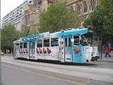
The Melbourne Tram Route 67 is an Australia
n tram
route which runs back and forth from Carnegie
to the University of Melbourne
.
The route starts at the Carnegie terminus, located in Trugininni Road at the corner of Koornang Road, and travels via Glen Huntly Road, Brighton Road, St Kilda Road
and Swanston St
to the Melbourne University terminus.
The service is operated by Z1, Z2, Z3 and B2 class trams.
On average, a journey in peak hour takes approximately an hour from end to end.
A truncated, off-peak version of route 67 exists as route 66. This route also begins at the University of Melbourne, but ends at Glenhuntly Tram Depot
in South Caulfield. It only operates in the direction away from the city.
The Public Transport Users Association
is campaigning for an extension of route 67 to Carnegie railway station.
on route 67.
Starts at University of Melbourne terminus (stop 1), Swanston
and Faraday Streets; then runs via:
Ends at Koornang Road, Carnegie.
Australia
Australia , officially the Commonwealth of Australia, is a country in the Southern Hemisphere comprising the mainland of the Australian continent, the island of Tasmania, and numerous smaller islands in the Indian and Pacific Oceans. It is the world's sixth-largest country by total area...
n tram
Tram
A tram is a passenger rail vehicle which runs on tracks along public urban streets and also sometimes on separate rights of way. It may also run between cities and/or towns , and/or partially grade separated even in the cities...
route which runs back and forth from Carnegie
Carnegie, Victoria
Carnegie is a suburb in Melbourne, Victoria, Australia, 12 km south-east from Melbourne's central business district. Its Local Government Area is the City of Glen Eira. At the 2006 Census, Carnegie had a population of 15,084...
to the University of Melbourne
University of Melbourne
The University of Melbourne is a public university located in Melbourne, Victoria. Founded in 1853, it is the second oldest university in Australia and the oldest in Victoria...
.
The route starts at the Carnegie terminus, located in Trugininni Road at the corner of Koornang Road, and travels via Glen Huntly Road, Brighton Road, St Kilda Road
St Kilda Road, Melbourne
St Kilda Road is a street in Melbourne, Victoria, Australia. It is part of the locality of Melbourne which has the postcode of 3004 and along with Swanston Street forms a major spine of the city....
and Swanston St
Swanston Street, Melbourne
Swanston Street is a major thoroughfare in the centre of Melbourne, Australia. It is historically one of the main streets of central Melbourne, laid out in 1837 as part of the Hoddle Grid, the layout of major streets that makes up the central business district...
to the Melbourne University terminus.
The service is operated by Z1, Z2, Z3 and B2 class trams.
On average, a journey in peak hour takes approximately an hour from end to end.
A truncated, off-peak version of route 67 exists as route 66. This route also begins at the University of Melbourne, but ends at Glenhuntly Tram Depot
Glenhuntly Tram Depot
Glenhuntly Tram Depot is located in South Caulfield, a suburb of Melbourne in Victoria, Australia.It is one of 8 depots operated in the Yarra Trams network. The depot was opened in 1923.- Yard layout :...
in South Caulfield. It only operates in the direction away from the city.
The Public Transport Users Association
Public Transport Users Association
The Public Transport Users Association is a community-based public transport lobby group in Victoria, Australia, based in Melbourne.- History and Aims :...
is campaigning for an extension of route 67 to Carnegie railway station.
Route
There are 68 stopsTram stop
A tram stop is a place designated for a tram to stop so passengers can board or alight it. Tram stops share most characteristics of bus stops, but because trams operate on rails, they often include railway platforms, especially if stepless entries are provided for accessibility...
on route 67.
Starts at University of Melbourne terminus (stop 1), Swanston
Swanston Street, Melbourne
Swanston Street is a major thoroughfare in the centre of Melbourne, Australia. It is historically one of the main streets of central Melbourne, laid out in 1837 as part of the Hoddle Grid, the layout of major streets that makes up the central business district...
and Faraday Streets; then runs via:
- Swanston StreetSwanston Street, MelbourneSwanston Street is a major thoroughfare in the centre of Melbourne, Australia. It is historically one of the main streets of central Melbourne, laid out in 1837 as part of the Hoddle Grid, the layout of major streets that makes up the central business district...
(stops 1 - 13)- La Trobe StreetLa Trobe Street, MelbourneLa Trobe Street is a major street in the central business district of Melbourne, Victoria, Australia. It runs roughly from east to west and forms the northern boundary of the CBD ....
, RMIT UniversityRMIT UniversityRMIT University is an Australian public university located in Melbourne, Victoria. It has two branches, referred to as RMIT University in Australia and RMIT International University in Vietnam....
, State Library of VictoriaState Library of VictoriaThe State Library of Victoria is the central library of the state of Victoria, Australia, located in Melbourne. It is on the block bounded by Swanston, La Trobe, Russell, and Little Lonsdale streets, in the northern centre of the central business district...
, Melbourne CentralMelbourne CentralMelbourne Central may refer to:*Melbourne Central Shopping Centre*Melbourne Central railway station...
shopping centre and railway station, tram routes 24Melbourne tram route 24Tram route 24 is a public transport service in Melbourne, Victoria, Australia, which runs from La Trobe Street in the city centre, to North Balwyn. Like most tram routes in Melbourne, it falls within Metcard ticketing Zone 1....
, 30Melbourne tram route 30Tram route 30 is a public transport service in Melbourne, Victoria, Australia. It runs from St Vincents Plaza to Etihad Stadium. It only runs on weekdays, during daylight hours and is one of three fare paying routes to use heritage W class trams....
, 34 and the City CircleCity Circle (tram route)The City Circle is a zero-fare tram running around the central business district of Melbourne, Australia. Aimed towards tourists the route passes many Melbourne attractions while running along the CBD's outermost thoroughfares, as well as the developing Docklands waterfront precinct.- History :The...
(stop 8) - Lonsdale StreetLonsdale Street, MelbourneLonsdale Street is located in the centre of Melbourne, Victoria, Australia, part of the Hoddle Grid, it runs roughly east-west. Lonsdale Street's eastern end intersects with Spring Street while its western end intersects with Spencer Street. It is home to multiple office buildings, courts,...
, QV VillageQueen Victoria VillageQueen Victoria Village, generally known as QV Village or just QV, is a precinct in the central business district of Melbourne, Victoria, Australia...
(stop 9) - Bourke StreetBourke Street, MelbourneBourke Street is one of Melbourne's best known streets. Historically been regarded as Melbourne's "second street", with the main street being Collins Street and "busier than Bourke Street" is a popular catchphrase. Bourke Street has traditionally been Melbourne's entertainment hub...
, tram routes 86Melbourne tram route 86Tram route 86 is a public transport service in Melbourne, Victoria, Australia. It runs from Bundoora in the northern suburbs to Waterfront City Docklands in the city. It is one of Melbourne's busiest tram routes carrying 44,200 passengers a day...
, 95 and 96Melbourne tram route 96Melbourne tram route 96 is a public transport tram and light rail route in Melbourne, Victoria, Australia.It is one of Melbourne's busiest tram route carrying 39,700 passengers a day with a frequency of every 10 minutes or less during peak...
(stop 10) - Collins StreetCollins Street, MelbourneCollins Street is a major street in the Melbourne central business district and runs approximately east to west.It is notable as Melbourne's traditional main street and best known street, is often regarded as Australia's premier street, with some of the country's finest Victorian era buildings.The...
, Melbourne Town HallMelbourne Town HallMelbourne Town Hall is the central municipal building of the City of Melbourne, Australia, in the State of Victoria. It is located on the northeast corner of Swanston and Collins Streets, in the central business district. It is the seat of the Local Government Area of the City of Melbourne...
, Melbourne City Square, tram routes 11, 12, 42, 48Melbourne tram route 48Tram route 48 is a public transport service in Melbourne, Victoria, Australia. It runs from Victoria Harbour, Docklands to North Balwyn via Collins Street, Spring Street, Wellington Parade and Bridge Road...
, 109Melbourne tram route 109Tram route 109 or simply The 109 is a public transport service in Melbourne, Victoria, Australia. It runs between a terminus in Box Hill and a terminus near Station Pier in Port Melbourne...
and 112Melbourne tram route 112Tram route 112 is a public transport service in Melbourne, Victoria, Australia. It runs from West Preston, in the northern suburbs to St Kilda.Like most tram routes in Melbourne, it falls within Metcard/myki ticketing Zone 1....
(stop 11) - Flinders StreetFlinders Street, MelbourneFlinders Street is a notable street in Melbourne, Victoria, Australia. Running roughly parallel to the Yarra River, Flinders Street forms the southern edge of the Hoddle Grid. It is exactly one mile in length and one and half chains in width...
, Flinders Street StationFlinders Street StationFlinders Street Station is the central railway station of the suburban railway network of Melbourne, Victoria, Australia. It is on the corner of Flinders and Swanston Streets next to the Yarra River in the heart of the city, stretching from Swanston Street to Queen Street and covering two city...
, Federation SquareFederation SquareFederation Square is a civic centre and cultural precinct in the city of Melbourne, Victoria, Australia....
, St Paul's CathedralSt Paul's Cathedral, MelbourneSt Paul's Cathedral, Melbourne, is the metropolitical and cathedral church of the Anglican Diocese of Melbourne, Victoria in Australia. It is the seat of the Anglican Archbishop of Melbourne and Metropolitan of the Province of Victoria...
, tram routes 70Melbourne tram route 70Tram route 70 is a public transport service in Melbourne, Victoria, Australia. It is operated by Camberwell Depot and runs from the Waterfront City Docklands to Wattle Park in Box Hill South...
, 75Melbourne tram route 75Tram route 75 is a public transport service in Melbourne, Victoria, Australia. It runs from the corner of Spencer Street and La Trobe Street in the city centre to Vermont South in the eastern suburbs....
and the City CircleCity Circle (tram route)The City Circle is a zero-fare tram running around the central business district of Melbourne, Australia. Aimed towards tourists the route passes many Melbourne attractions while running along the CBD's outermost thoroughfares, as well as the developing Docklands waterfront precinct.- History :The...
(stop 13)
- La Trobe Street
- St Kilda RoadSt Kilda Road, MelbourneSt Kilda Road is a street in Melbourne, Victoria, Australia. It is part of the locality of Melbourne which has the postcode of 3004 and along with Swanston Street forms a major spine of the city....
(stops 14 - 35)- Victorian Arts Centre (stop 14)
- National Gallery of VictoriaNational Gallery of VictoriaThe National Gallery of Victoria is an art gallery and museum in Melbourne, Australia. Founded in 1861, it is the oldest and the largest public art gallery in Australia. Since December 2003, NGV has operated across two sites...
, Queen Victoria GardensQueen Victoria Gardens, MelbourneThe Queen Victoria Gardens are Melbourne's memorial to Queen Victoria. Located on 4.8 hectares opposite the Victorian Arts Centre and National Gallery of Victoria, bounded by St Kilda Road, Alexandra Avenue and Linlithgow Avenue....
(stop 15) - Southbank Boulevard, tram route 1Melbourne tram route 1Tram route 1 is a public transport service in Melbourne, Victoria, Australia. It runs from the terminus at Nicholson Street and Bell Street in East Coburg to the corner of Victoria Avenue and Beaconsfield Parade in Albert Park....
(stop 16) - Shrine of RemembranceShrine of RemembranceThe Shrine of Remembrance, located in Kings Domain on St Kilda Road, Melbourne, Australia was built as a memorial to the men and women of Victoria who served in World War I and is now a memorial to all Australians who have served in war...
(stop 19) - Domain Interchange, tram routes 8Melbourne tram route 8Tram route 8 is a public transport service in Melbourne, Victoria, Australia. It runs from Toorak to Moreland through the suburbs of Carlton and South Yarra...
and 55Melbourne tram route 55Tram route 55 is a public transport service in Melbourne, Victoria, Australia. It runs from the corner of Bell Street and Melville Road in West Coburg to the Domain Road Interchange - Domain Road and St Kilda Road east of the city....
(stop 20) - Commercial Road, tram route 72Melbourne tram route 72Tram route 72 is a public transport service in Melbourne, Victoria, Australia. It runs from the University of Melbourne in the city centre to Camberwell in the eastern suburbs. It runs through the suburbs of Melbourne, South Yarra, Toorak, Malvern, Glen Iris, and Camberwell...
(stop 25) - High Street, Victorian College for the DeafVictorian College for the DeafThe Victorian College for the Deaf , located on St Kilda Road in Melbourne, Australia, is Victoria's oldest deaf school, opening in 1860. It currently provides education in Auslan, the language of the Australian Deaf community, from prep through to year 12...
, tram route 6Melbourne tram route 6Tram route 6 is a public transport service in Melbourne, Victoria, Australia. It runs from the University of Melbourne in the city centre to Glen Iris in the eastern suburbs....
(stop 27) - St Kilda JunctionSt Kilda JunctionSt Kilda Junction is one of the most notorious intersections in Melbourne, Australia. It is located in the suburb of St Kilda, and bordering Windsor, Melbourne and St Kilda East, and is the meeting point of the major roads Punt Road, St Kilda Road, Dandenong Road/Queens Way/Princes Highway and...
, Junction OvalJunction OvalThe Junction Oval is an historic sports ground in the suburb of St Kilda in Melbourne, Victoria, Australia. Its location near the St Kilda Junction gave rise to its nickname...
, tram routes 5Melbourne tram route 5Tram route 5 is a public transport service in Melbourne, Victoria, Australia. It runs from the University of Melbourne north of the city centre to Malvern East in the eastern suburbs. The destination is, however, displayed as Malvern, although the route technically ends within Malvern East...
and 64Melbourne tram route 64Tram route 64 is a public transport service in Melbourne, Victoria, Australia. It runs from the University of Melbourne in the city centre to East Brighton in the southern suburbs. It runs through the suburbs of Melbourne, Windsor, Caulfield, and Brighton East...
(stop 30)
- Brighton Road (stops 35-44)
- Carlisle Street, tram routes 3Melbourne tram route 3Tram route 3 is a public transport service in Melbourne, Victoria, Australia. It runs from the University of Melbourne north of the city centre to Malvern East in the eastern suburbs....
, 16Melbourne tram route 16Tram route 16 is a public transport service in Melbourne, Victoria, Australia. It runs from the University of Melbourne in the city centre to Kew in the eastern suburbs. It runs through the suburbs of Melbourne, St Kilda, Balaclava, Malvern, and Kew...
and 79Melbourne tram route 79Tram route 79 is a public transport service in Melbourne, Victoria, Australia. It runs from North Richmond to St Kilda Beach through the suburbs of South Yarra, Prahran, Windsor, Balaclava, and St, Kilda. Like most tram routes in Melbourne, it is entirely within Metcard ticketing Zone 1...
(stop 35) - Chapel StreetChapel Street, MelbourneChapel Street is a shopping, dining and entertainment precinct in Melbourne, Australia. It has a myriad shops ranging from exclusive upmarket fashion designers at the South Yarra end to old fashion pawnbrokers towards Windsor.-Geography:...
, tram route 78Melbourne tram route 78Tram route 78 is a public transport service in Melbourne, Victoria, Australia. The route starts at the Victoria St terminus , then runs along Church St, Richmond, crossing Bridge Rd and Swan St . It continues over the Yarra River along Chapel St, crossing Toorak Rd at stop 49...
(stop 37) - Glen Eira Road, Ripponlea railway station (stop 39)
- Carlisle Street, tram routes 3
- Glen Huntly Road (stops 44-68)
- Elsternwick railway station (stop 44)
- Hawthorn Road, tram routes 64Melbourne tram route 64Tram route 64 is a public transport service in Melbourne, Victoria, Australia. It runs from the University of Melbourne in the city centre to East Brighton in the southern suburbs. It runs through the suburbs of Melbourne, Windsor, Caulfield, and Brighton East...
(stop 51) - Glenhuntly Tram DepotGlenhuntly Tram DepotGlenhuntly Tram Depot is located in South Caulfield, a suburb of Melbourne in Victoria, Australia.It is one of 8 depots operated in the Yarra Trams network. The depot was opened in 1923.- Yard layout :...
(stop 53) - Glenhuntly railway station (stop 60)
Ends at Koornang Road, Carnegie.